La Vérendrye, La Verendrye or Verendrye may refer to:
The Vérendrye stone was allegedly found on an early expedition into the territory west of the Great Lakes by the French Canadian explorer Pierre Gaultier de Varennes et de La Vérendrye, in the 1730s. It is not mentioned in the official records of La Vérendrye's expeditions, but in 1749 he discussed it with visiting Swedish scientist Pehr Kalm, from whose writings virtually all information about the stone is taken.
Jean-Baptiste Gaultier de la Vérendrye was the eldest son of Pierre Gaultier de Varennes et de La Vérendrye and Marie-Anne Dandonneau Du Sablé. He was born on Île Dupas near Sorel, New France

Pierre Gaultier de La Vérendrye de Boumois was the second son of Pierre Gaultier de Varennes, sieur de La Vérendrye. An explorer and fur trader who served many years under the command of his father, he was born on Île aux Vaches, near Sorel, New France.
François de La Vérendrye was a Canadian explorer He was the third son of Pierre Gaultier de Varennes, sieur de La Vérendrye. He was born at Sorel, New France in 1715 and was active in his father's trade activities from Fort Kaministiquia to the North Saskatchewan River.
Jacques Legardeur de Saint-Pierre was a Canadian colonial military commander and explorer who held posts throughout North America in the 18th century, just before and during the French and Indian War.

Fort La Reine was built in 1738 and is one of the forts of the western expansion directed by Pierre Gaultier de Varennes et de La Vérendrye, first military commander in the west of what is now known as Canada. Located on the Assiniboine River where present day Portage la Prairie, Manitoba, stands, the fort served as a fur trading post. It was also the base of operations for much exploration north and west. From Fort La Reine, explorers made their way to Lake Manitoba and Lake Winnipegosis, Lake Winnipeg and the Saskatchewan River.

Not to be confused with the Fort Maurepas built in 1699 on the Gulf of Mexico
Fort Rouge was a fort located on the Assiniboine River in Manitoba, Canada, on the site of what is now the city of Winnipeg. Its exact location is unknown. Its name in English means "red fort".

Monument Hill and Kreische Brewery State Historic Sites is a historic state park located at 29.888° -96.876°, just off U.S. Route 77, south of La Grange, Texas. The park sits on a sandstone bluff above the Colorado River. Monument Hill is a crypt and memorial to the men who died in the Dawson Massacre and in the Black Bean Episode of the ill-fated Mier Expedition.
Verendrye National Monument was a federally protected area in the U.S. state of North Dakota from 1917 to 1956. In the latter year it was withdrawn as a national monument. It is located in southwestern Mountrail County, west of the city of New Town. It lies within the Fort Berthold Indian Reservation.
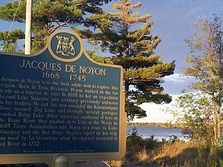
Jacques de Noyon was a French Canadian explorer and coureur des bois. He is the first known European to visit the Boundary Waters region west of Lake Superior.
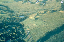
The Menoken Indian Village Site, also known as Menoken Site, Verendrye Site or Apple Creek Site is an archeological site near Bismarck, North Dakota. The site, that of a fortified village occupied c. 1300, is important in the region's prehistory, as it is one of the only sites that predates sites that are more clearly associated with the historic Hidatsa, Mandan, and Arikara cultures. It was declared a National Historic Landmark in 1964. It is located on 171st Street NE, north of Menoken, about 10 miles (16 km) east of Bismarck. The site managed by the state as the Menoken Indian Village State Historic Site, and is open to the public.

Fort De La Boulaye Site, also known as Fort Mississippi, is the site of a fort built by the French in 1699–1700, to support their claim of the Mississippi River and valley. Native Americans forced the French to vacate the fort by 1707.
Fort Pierre Chouteau, also just Fort Pierre, was a major trading post and military outpost in the mid-19th century on the west bank of the Missouri River in what is now central South Dakota. Established in 1832 by Pierre Chouteau, Jr. of St. Louis, Missouri, whose family were major fur traders, this facility operated through the 1850s.

Verendrye is an unincorporated community in McHenry County, North Dakota, United States, located about 8 miles northwest of Karlsruhe and 13 miles northeast of Velva within Falsen Township. Although classified by the USGS as a populated place, it is considered a ghost town.
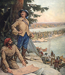
The Vérendrye brothers were the first Europeans to cross the northern Great Plains and see the Rocky Mountains (1742–43). We know very little about their journey. All we know comes from a journal found in the French archives in 1851 and a lead plate commemorating the journey which was found in 1913 buried near Pierre, South Dakota. The journal and lead plate are difficult to interpret. The journal states the trip may made by the "Chevalier Vérendrye and one of his brothers" who are otherwise unidentified. Most likely the Chevalier was Louis-Joseph Gaultier de La Vérendrye and the brother was François de La Vérendrye but we cannot be sure. The mountains they saw during their expeditions may have been the Big Horn Mountains of Wyoming, but could also have been the Black Hills or the Laramie Mountains


