The Sioux Quartzite is a Proterozoicquartzite that is found in the region around the intersection of Minnesota, South Dakota, and Iowa, and correlates with other rock units throughout the upper midwestern and southwesternUnited States. It was formed by braided river deposits, and its correlative units are thought to possibly define a large sedimentary wedge that once covered the passive margin on the then-southern side of the North American craton. In human history, it provided the catlinite, or pipestone, that was used by the Plains Indians to carve ceremonial pipes. With the arrival of Europeans, it was heavily quarried for building stone, and was used in many prominent structures in Sioux Falls, South Dakota and shipped to construction sites around the Midwest. Sioux Quartzite has been and continues to be quarried in Jasper, Minnesota at the Jasper Stone Company and Quarry, which itself was posted to the National Register of Historic Places on January 5, 1978.[1]Jasper, Minnesota contains many turn-of-the-century quartzite buildings, including the school, churches and several other public and private structures, mostly abandoned.
Its age is constrained to be between 2280 ± 110 Ma[4] from the uranium-lead dating of a rhyolite that underlies it in northwestern Iowa, and 1120 Ma[5] from a potassium-argon date of deformation of the Sioux Quartzite in Pipestone, Minnesota. Its age can be better-constrained by extrapolation correlative units to between 1760 ± 10 Ma[6] and 1640 ± 40 Ma.[7] This period in which the Sioux Quartzite and its correlative units were deposited is known as the Baraboo interval, in which high relative sea levels covered a large amount of North America.[8]
The Sioux quartzite was primarily formed by braided river deposits, of quartz arenite composition, with 95% of the rock being composed of rounded, fine to medium (0.125–0.5mm) sand-size quartzgrains.[3] The rivers are believed to flow southeast, at a relatively shallow gradient.[3] Its basal conglomerate is thought to be braided stream deposits that are more proximal to the source, and there is possible marine influence on the upper part of the unit – this interpretation is supported by evidence of marine sediments (shales and banded iron formations) atop its correlative unit in Baraboo, Wisconsin.[9] In addition, the unit contains ~1 meter beds of claystone, which are known as catlinite or pipestone, because these beds were used by the natives of the area to carve pipe bowls.[3] It is thought that the Sioux Quartzite and its correlative units are parts of a once-laterally-extensive sedimentary wedge that covered the then-southern passive margin of the North American craton.[8]
The Sioux Quartzite is extremely resistant to erosion, and has formed a topographic high through most of Phanerozoic time. It was inundated by Phanerozoic seas during the periods of maximum sea level, and subsequent erosion removed these sedimentary units. For this reason, the only geologic units to sit atop the Sioux Quartzite are of Cretaceous age, deposited when a large portion of North America was covered by the Western Interior Seaway.
Hattie Phillips House, Sioux Falls, South Dakota, 1885, razed 1966, however foundation reused[14]
Pipestone City Hall, Pipestone, Minnesota, 1896 now the Pipestone County Museum
1884 Syndicate Block, shop buildings in Pipestone, Minnesota
The Calumet Inn, Pipestone, Minnesota
Several buildings at the South Dakota School for the Deaf - high school (1885/1912), administration (1883), gym (1900/1929/1938), and other buildings/additions since razed
Queen Bee Mill in Falls Park
Old Sioux Falls Light & Power hydro plant in Falls Park
South Dakota State Penitentiary, Sioux Falls SD, 1881
The Pipestone County Courthouse, Pipestone, Minnesota, 1902
Old Central School opened its door in 1879, which was later known as Washington High School, in Sioux Falls, South Dakota. Now bearing the name, Washington Pavilion, it opened its doors in 1999 as an arts and science center. Sioux Falls, South Dakota
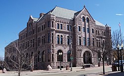
The Old Courthouse Museum, Sioux Falls, South Dakota, Built in the 1800s.
Wamego City Park, Wamego, Kansas, where a number of structures are built using local glacial erratics from the Sioux Quartzite
Perhaps the most unusual construction involved Sioux quartzite and petrified wood:
The Pettigrew home and museum
Thomas and Jenny McMartin home, aka Pettigrew Home and Museum, Sioux Falls, South Dakota, 1889
The Sioux Falls Carnegie Library is located at 235 West 10th Street in Sioux Falls, South Dakota. It was built in 1903 and listed on the National Register of Historic Places in 1994.
The former administration and high school buildings and the current gymnasium building on the South Dakota School for the Deaf campus
↑ Morey, B. G., 1985, Sedimentology of the Sioux Quartzite in the Fulda Basin, Pipestone County, southwestern Minnesota, in Southwick, D. L., cd., Shorter contributions to the geology of the Sioux Quartzite (Early Proterozoic), southwestern Minnesota: Minnesota Geological Survey Report of Investigations 32, pp. 59–74.
1 2 3 4 5 Anderson, R. R., 1987, Precambrian Sioux Quartzite at Gitchie Manitou State Preserve, Iowa. Centennial Field Guide Volume 3: North-Central Section of the Geological Society of America: Vol. 3, No. 0 pp. 77–80.
↑ Van Schmus, W. R., Bickford, M, E., and Zietz, I., 1986, Early and Middle Proterozoic provinces in the central United States, in Kroner, A., ed., Proterozoic Lithospheric Evolution: American Geophysical Union Geodynamics series, v. 17, pp. 43–68.
↑ Goldich, S. S., Nier, A. O., Baagsgaard, H., Hoffman, J. H., and Krueger, H. W., 1961, The Precambrian geology and geochronology of Minnesota: Minnesota Geological Survey Bulletin 41, 193 p.
↑ U-Pb dating by Van Schmus, 1979, Geochronology of the southern Wisconsin rhyolites and granites: University of Wisconsin Extension, Geoscience Wisconsin, v. 2, pp. 9–24.
↑ Van Schmus, W. R., Thurman, M. E., and Petermann, A. E., 1975, Geology and Rb-Sr chronology of middle Precambrian rocks in eastern and central Wisconsin: Geological Society of America Bulletin, v. 86, pp. 1255–1265.
1 2 Dott, R. H., Jr., 1983, The Baraboo interval; A tale of red quartzite Geological Society of America Abstracts with Programs, v. 15, p. 209.
↑ Ojakangas, R. W., and Weber, R. E., 1985, Petrography and paleocurrents of the Lower Proterozoic Sioux Quartzite, Minnesota and South Dakota, in Southwick, D. L., ed., Shorter contributions to the geology of the Sioux Quartzite (Early Proterozoic), southwestern Minnesota: Minnesota Geological Survey Report of Investigations 32, pp. 1–15.
↑ Bierman, P (1999). "Mid-Pleistocene cosmogenic minimum-age limits for pre-Wisconsinan glacial surfaces in southwestern Minnesota and southern Baffin Island: a multiple nuclide approach". Geomorphology. 27 (1–2): 25–39. Bibcode:1999Geomo..27...25B. doi:10.1016/S0169-555X(98)00088-9.
This page is based on this Wikipedia article Text is available under the CC BY-SA 4.0 license; additional terms may apply. Images, videos and audio are available under their respective licenses.