Bonneterre Formation

Last updated
Bonneterre Formation
Stratigraphic range: Guzhangian (Dresbachian)
~501–497  Ma
O
S
D
C
P
T
J
K
Pg
N
Galena in dolostone (Bonneterre Dolomite, Upper Cambrian; Flat Rock, Old Lead Belt, Missouri, USA) 2 (40704497164).jpg
Galena in Bonneterre Dolomite (Upper Cambrian; Missouri)
Type Formation
Underlies Davis Formation
Overlies Lamotte Sandstone [1]
Lithology
Primary Dolomite
Other Shale, limestone, sandstone
Location
Coordinates 37°38′10″N90°34′41″W / 37.636°N 90.578°W / 37.636; -90.578
Approximate paleocoordinates 22°54′S86°30′W / 22.9°S 86.5°W / -22.9; -86.5
Region Arkansas, [2] Kansas, [3] Illinois, Iowa, [4] Minnesota, [4] Missouri
CountryFlag of the United States (23px).png  United States
Usa edcp relief location map.png
Dark Green 004040 pog.svg
Bonneterre Formation (the United States)
USA Missouri relief location map.svg
Dark Green 004040 pog.svg
Bonneterre Formation (Missouri)

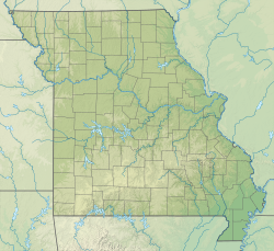
The Bonneterre Formation is an Upper Cambrian geologic formation which outcrops in the St. Francois Mountains of the Missouri Ozarks. The Bonneterre is a major host rock for the lead ores of the Missouri Lead Belt.

Contents

Description

The formation is dominantly dolomite with areas or layers of pure limestone. A shaley or glauconitic zone occurs in the lower portion and the base contains sand and conglomerate or breccia where the formation overlaps the Lamotte and lies directly on the granite of the mountain core. [5]

Stratigraphy

Early geologists offered a variety of names for what is now known as the Bonneterre Formation. [1] In 1894, Missouri state geologist Arthur Winslow proposed St. Francois limestone as a name for thick limestone beds, [6] including everything between what are now known as the Lamotte Sandstone and the St. Peter Sandstone. [7] He described the lower part of that formation (now comprising the Bonneterre and the Elvins Group) [8] separately as the St. Joseph limestone. [9] Charles Rollin Keyes's Fredericktown limestone included everything between the Lamotte and the Potosi Dolomite when he first described it in 1896, but his later uses of the name were in a more restricted sense equivalent to the modern Bonneterre. [10]

In 1901, Frank Lewis Nason was the first to apply the name Bonneterre (originally spelled Bonne Terre) to these rocks, [1] identifying a type section near the city of Bonne Terre, Missouri. [11]

Contacts

The Bonneterre is conformably overlain by the Davis Formation. The Bonneterre Formation lies conformably on the Lamotte Sandstone and in places lies directly on the Proterozoic igneous core of the mountains.

Thickness

In the outcrop area the Bonneterre has an average thickness of 375 to 400 feet. It is present in the subsurface throughout Missouri and has a maximum recorded thickness of 1580 feet under Pemiscot County in the Missouri Bootheel. [5]

Fossils

The dolomites and limestones of the Bonneterre Formation contain fossils of late Cambrian invertebrates. Algal stromatolites, echinoderms, and microfossils such as Girvanella are associated with fringing reef paleoecosystems surrounding the Cambrian islands that are now the St. Francois Mountains. [12] A variety of trilobite fossils have been reported from the Bonneterre, including Coosella , Holcacephalus , Meteoraspis , Tricrepicephalus , and Welleraspis . [13] [14] Several monoplacophorans have also been described from the Bonneterre; one, Hypseloconus bonneterrense is named for the formation. [14] [15]

Related Research Articles

<span class="mw-page-title-main">Ozarks</span> Highland region in central-southern United States

The Ozarks, also known as the Ozark Mountains, Ozark Highlands or Ozark Plateau, is a physiographic region in the U.S. states of Missouri, Arkansas, Oklahoma and the extreme southeastern corner of Kansas. The Ozarks cover a significant portion of northern Arkansas and most of the southern half of Missouri, extending from Interstate 40 in central Arkansas to Interstate 70 in central Missouri.

<span class="mw-page-title-main">Southeast Missouri Lead District</span> Lead mining area in Missouri, US

The Southeast Missouri Lead District, commonly called the Lead Belt, is a lead mining district in the southeastern part of Missouri. Counties in the Lead Belt include Saint Francois, Crawford, Dent, Iron, Madison, Reynolds, and Washington. This mining district is the most important and critical lead producer in the United States.

<span class="mw-page-title-main">Ozark Highlands (ecoregion)</span>

The Ozark Highlands is a Level III ecoregion designated by the Environmental Protection Agency (EPA) in four U.S. states. Most of the region is within Missouri, with a part in Arkansas and small sections in Oklahoma and Kansas. It is the largest subdivision of the region known as the Ozark Mountains, less rugged in comparison to the Boston Mountains in Arkansas, the highest part of the Ozarks.

Hemithecella is a problematic genus of Ordovician mollusc proposed by Stinchcomb and Darrough in 1995. Hemithecella belongs to what are informally known as multiplated molluscs; it is found in the late Cambrian of the Ozarks and the Lower Ordovician of the same region as well as in Minnesota and the southern Appalachian Mountains. Hemithecella has muscle scars identical to a monoplacophoran and not the musculature of a chiton to which some authors have suggested the multiplated molluscs belong. It is therefore classified in the Mattheviidae.

<span class="mw-page-title-main">Tonto Group</span> Cambrian geologic unit in the Grand Canyon region, Arizona

The Tonto Group is a name for an assemblage of related sedimentary strata, collectively known by geologists as a Group, that comprises the basal sequence Paleozoic strata exposed in the sides of the Grand Canyon. As currently defined, the Tonto groups consists of the Sixtymile Formation, Tapeats Sandstone, Bright Angel Shale, Muav Limestone, and Frenchman Mountain Dolostone. Historically, it included only the Tapeats Sandstone, Bright Angel Shale, and Muav Limestone. Because these units are defined by lithology and three of them interfinger and intergrade laterally, they lack the simple layer cake geology as they are typically portrayed as having and geological mapping of them is complicated.

<span class="mw-page-title-main">Munising Group</span> Geologic formation in Michigan and Ontario

The Munising Group or Formation is a 1,700 feet (520 m) thick, white to light grey Cambrian sedimentary unit that crops out in Michigan and Ontario. At one end of its extent, it comprises a basal conglomerate overlain by the Chapel Rock Member and the Miners Castle Member; elsewhere, it comprises the Eau Claire, Galesville (=Dresbach), and Franconia Members. Anhydritic evaporite deposits are present in places. The conglomerate was deposited by rivers in flood, with the Chapel Rock member, which contains deltaic deposits, representing transgression as the conglomerate cones became submerged; the Miners Castle member was deposited further from the shoreline, representing shelf deposits. Its uppermost strata may be Early Ordovician in age, and contain conodonts, trilobites and phosphatic moulds of brachiopods, ostrocoderm fish and gastropods.

<span class="mw-page-title-main">Bright Angel Shale</span> Cambrian geologic formation found in the Southwestern United States

The Bright Angel Shale is one of five geological formations that comprise the Cambrian Tonto Group. It and the other formations of the Tonto Group outcrop in the Grand Canyon, Arizona, and parts of northern Arizona, central Arizona, southeast California, southern Nevada, and southeast Utah. The Bright Angel Shale consists of locally fossiliferous, green and red-brown, micaceous, fissile shale (mudstone) and siltstone with local, thicker beds of brown to tan sandstone and limestone. It ranges in thickness from 57 to 450 feet. Typically, its thin-bedded shales and sandstones are interbedded in cm-scale cycles. They also exhibit abundant sedimentary structures that include current, oscillation, and interference ripples. The Bright Angel Shale also gradually grades downward into the underlying Tapeats Sandstone. It also complexly interfingers with the overlying Muav Limestone. These characters make the upper and lower contacts of the Bright Angel Shale often difficult to define. Typically, its thin-bedded shales and sandstones erode into green and red-brown slopes that rise from the Tonto Platform up to cliffs formed by limestones of the overlying Muav Limestone and dolomites of the Frenchman Mountain Dolostone.

<span class="mw-page-title-main">Roubidoux Formation</span> Geologic formation in the Ozarks of Missouri

The Roubidoux Formation is a geologic formation in the Ozarks of Missouri. It preserves fossils dating back to the Ordovician period.

<span class="mw-page-title-main">Bloyd Formation</span>

The Bloyd Formation, or Bloyd Shale, is a geologic formation in Arkansas. It preserves fossils dating back to the Carboniferous period.

The Eminence Formation or Eminence Dolomite is a geologic formation in Missouri. It preserves fossils dating back to the Cambrian period.

<span class="mw-page-title-main">Potosi Dolomite</span> Geologic formation

The Potosi Formation is a geologic formation in Missouri, Illinois and Indiana. It preserves fossils dating back to the Cambrian period.

The Jefferson City Formation or Jefferson City Dolomite is a geologic formation in the Ozarks of Missouri and Arkansas. The Jefferson City is in part not differentiated from the Cotter Formation of northern Arkansas. It preserves fossils dating back to the Ordovician period.

<span class="mw-page-title-main">Gasconade Formation</span> Geologic formation in Missouri, United States

The Gasconade Formation is a geologic formation in the Ozarks of Missouri. It preserves fossils dating back to the Ordovician Period.

<span class="mw-page-title-main">Tunnel Mountain Formation</span> Geologic formation in Alberta, Canada

The Tunnel Mountain Formation is a geologic formation that is present on the western edge of the Western Canada Sedimentary Basin in the Canadian Rockies of western Alberta. Named after Tunnel Mountain near Banff, it was deposited during the Early Pennsylvanian sub-period of the Carboniferous period.

The Mount Whyte Formation is a stratigraphic unit that is present on the western edge of the Western Canada Sedimentary Basin in the southern Canadian Rockies and the adjacent southwestern Alberta plains. It was deposited during Middle Cambrian time and consists of shale interbedded with other siliciclastic rock types and limestones. It was named for Mount Whyte in Banff National Park by Charles Doolittle Walcott, the discoverer of the Burgess shale fossils, and it includes several genera of fossil trilobites.

The Waynesboro Formation is a limestone, dolomite, and sandstone geologic formation in Virginia, Maryland, Pennsylvania and West Virginia. In some areas it is composed of limestone and dolomite. The Waynsboro Formation is one of the formations that make up the Shenandoah Valley. It dates back to the Cambrian period and is not considered fossiliferous.

<span class="mw-page-title-main">Joachim Dolomite</span>

The Joachim Dolomite is a Middle Ordovician geologic formation in Arkansas, Illinois, and Missouri. The name was first introduced in 1894 by Arthur Winslow in his study of the geology of Missouri. Winslow designated a stratotype along Plattin Creek, which was misidentified as Joachim Creek, in Jefferson County. The name was introduced into Arkansas in 1911, replacing part of the, now abandoned, Izard Limestone.

Toad Formation, Grayling Formation, and Toad-Grayling Formation are obsolete names for the strata of the Early to Middle Triassic Doig and Montney Formations. They were applied in the foothills and Rocky Mountains of northeastern British Columbia, on the western edge of the Western Canada Sedimentary Basin. Although the names are considered obsolete, their usage persists.

The geology of Missouri includes deep Precambrian basement rocks formed within the last two billion years and overlain by thick sequences of marine sedimentary rocks, interspersed with igneous rocks by periods of volcanic activity. Missouri is a leading producer of lead from minerals formed in Paleozoic dolomite.

<span class="mw-page-title-main">Knox Supergroup</span> Widespread geologic group in the Southeastern United States

The Knox Supergroup, also known as the Knox Group and the Knox Formation, is a widespread geologic group in the Southeastern United States. The age is from the Late Cambrian to the Early Ordovician. Predominantly, it is composed of carbonates, chiefly dolomite, with some limestone. There are also cherty inclusions as well as thin beds of sandstone.

References

  1. 1 2 3 Thompson 2001, p. 37.
  2. Kurtz et al. 1975, p. 1.
  3. Goebel 1968, p. 12.
  4. 1 2 Mossler 1987, p. 6.
  5. 1 2 Thompson 1995, pp. 18–19.
  6. Winslow 1894, pp. 331, 346, 349–354.
  7. Thompson 2001, p. 250.
  8. Thompson 2001, p. 251.
  9. Winslow 1894, pp. 331, 347.
  10. Thompson 2001, p. 110.
  11. Nason, F.L. (1901). "On the presence of a limestone conglomerate in the lead region of St. Francois County, Missouri". American Journal of Science. 4th. 12: 358–361.
  12. Lyle, J. R. (1977). "Petrography and carbonate diagenesis of the Bonneterre Formation in the Viburnum Trend area, Southeast Missouri". Economic Geology. 72 (3): 420–434. doi:10.2113/gsecongeo.72.3.420.
  13. Hu, Chung-Hung (1979). "692. Ontogenies of four Upper Cambrian trilobites from the Bonneterre Dolomite, Missouri". Transactions and Proceedings of the Paleontological Society of Japan. New Series. 1978 (111): 348–357. doi:10.14825/prpsj1951.1978.111_348.
  14. 1 2 Stinchcomb, B. L (1975). "Paleoecology of two new species of Late Cambrian Hypseloconus (Monoplacophora) from Missouri". Journal of Paleontology. 49 (2): 416–421. JSTOR   1303372.
  15. Stinchcomb, Bruce; Angeli, Nicholas (2002). "New Cambrian and Lower Ordovician monoplacophorans form the Ozark Uplift, Missouri". Journal of Paleontology. 76 (6): 965–974. doi:10.1666/0022-3360(2002)076<0965:NCALOM>2.0.CO;2.

Bibliography