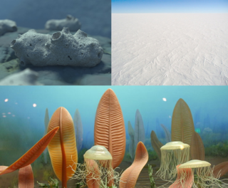
The Neoproterozoic Era is the last of the three geologic eras of the Proterozoic eon, spanning from 1 billion to 538.8 million years ago, and is the last era of the Precambrian "supereon". It is preceded by the Mesoproterozoic era and succeeded by the Paleozoic era of the Phanerozoic eon, and is further subdivided into three periods, the Tonian, Cryogenian and Ediacaran.
The Precambrian is the earliest part of Earth's history, set before the current Phanerozoic Eon. The Precambrian is so named because it preceded the Cambrian, the first period of the Phanerozoic Eon, which is named after Cambria, the Latinized name for Wales, where rocks from this age were first studied. The Precambrian accounts for 88% of the Earth's geologic time.
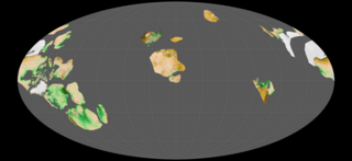
Rodinia was a Mesoproterozoic and Neoproterozoic supercontinent that assembled 1.26–0.90 billion years ago (Ga) and broke up 750–633 million years ago (Ma). Valentine & Moores 1970 were probably the first to recognise a Precambrian supercontinent, which they named "Pangaea I." It was renamed "Rodinia" by McMenamin & McMenamin 1990, who also were the first to produce a plate reconstruction and propose a temporal framework for the supercontinent.

The Proterozoic is the third of the four geologic eons of Earth's history, spanning the time interval from 2500 to 538.8 Mya, and is the longest eon of Earth's geologic time scale. It is preceded by the Archean and followed by the Phanerozoic, and is the most recent part of the Precambrian "supereon".

Arctica, or Arctida is a hypothetical ancient continent which formed approximately 2.565 billion years ago in the Neoarchean era. It was made of Archaean cratons, including the Siberian Craton, with its Anabar/Aldan shields in Siberia, and the Slave, Wyoming, Superior, and North Atlantic cratons in North America. Arctica was named by Rogers 1996 because the Arctic Ocean formed by the separation of the North American and Siberian cratons. Russian geologists writing in English call the continent "Arctida" since it was given that name in 1987, alternatively the Hyperborean craton, in reference to the hyperboreans in Greek mythology.

The Congo Craton, covered by the Palaeozoic-to-recent Congo Basin, is an ancient Precambrian craton that with four others makes up the modern continent of Africa. These cratons were formed between about 3.6 and 2.0 billion years ago and have been tectonically stable since that time. All of these cratons are bounded by younger fold belts formed between 2.0 billion and 300 million years ago.

The Tonian is the first geologic period of the Neoproterozoic Era. It lasted from 1000 to 720 Mya. Instead of being based on stratigraphy, these dates are defined by the ICS based on radiometric chronometry. The Tonian is preceded by the Stenian Period of the Mesoproterozoic Era and followed by the Cryogenian.
The Ectasian Period is the second geologic period in the Mesoproterozoic Era and lasted from 1400 Mya to 1200 Mya. Instead of being based on stratigraphy, these dates are defined chronometrically.
The Stenian Period is the final geologic period in the Mesoproterozoic Era and lasted from 1200 Mya to 1000 Mya. Instead of being based on stratigraphy, these dates are defined chronometrically. The name derives from narrow polymetamorphic belts formed over this period. It is preceded by the Ectasian Period and followed by the Neoproterozoic era and the Tonian period.
The Amazonian Craton is a geologic province located in South America. It occupies a large portion of the central, north and eastern part of the continent and represents one of Earth's largest cratonic regions. The Guiana Shield and Central Brazil Shield constitute respectively the northern and southern exhumed parts of the craton. Between the two shields lies the Amazon Rift, a zone of weakness within the craton. Smaller cratons of Precambrian rocks south of the Amazonian Shield are the Río de la Plata Craton and the São Francisco Craton, which lies to the east.

The Riphean is a stage or age of the geologic timescale from 1,600 to 600 million years ago. The name Riphean is used in the Proterozoic stratigraphy of Russia and the Fennoscandian Shield in Finland. It was also used in a number of older international geologic timescales but, in the most recent timescales of the ICS, it is replaced by the Calymmian, Ectasian, Stenian, Tonian and Cryogenian periods of the Neoproterozoic and Mesoproterozoic eras.

Laurentia or the North American Craton is a large continental craton that forms the ancient geological core of North America. Many times in its past, Laurentia has been a separate continent, as it is now in the form of North America, although originally it also included the cratonic areas of Greenland and the Hebridean Terrane in northwest Scotland. During other times in its past, Laurentia has been part of larger continents and supercontinents and consists of many smaller terranes assembled on a network of early Proterozoic orogenic belts. Small microcontinents and oceanic islands collided with and sutured onto the ever-growing Laurentia, and together formed the stable Precambrian craton seen today.
The Kibaran orogeny is a term that has been used for a series of orogenic events, in what is now Africa, that began in the Mesoproterozoic, around 1400 Ma and continued until around 1000 Ma when the supercontinent Rodinia was assembled. The term "Kibaran" has often been used for any orogenic rocks formed during this very extended period. Recently, it has been proposed that the term should be used in a much narrower sense for an event around 1375 Ma and a region in the southeast of the Democratic Republic of the Congo (DRC).

The Sveconorwegian orogeny was an orogenic system active 1140 to 960 million years ago and currently exposed as the Sveconorwegian orogenic belt in southwestern Sweden and southern Norway. In Norway the orogenic belt is exposed southeast of the front of the Caledonian nappe system and in nappe windows. The Sveconorwegian orogen is commonly grouped within the Grenvillian Mesoproterozoic orogens. Contrary to many other known orogenic belts the Sveconorwegian orogens eastern border does not have any known suture zone with ophiolites.
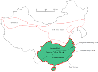
The South China Craton or South China Block is one of the Precambrian continental blocks in China. It is traditionally divided into the Yangtze Block in the NW and the Cathaysia Block in the SE. The Jiangshan–Shaoxing Fault represents the suture boundary between the two sub-blocks. Recent study suggests that the South China Block possibly has one more sub-block which is named the Tolo Terrane. The oldest rocks in the South China Block occur within the Kongling Complex, which yields zircon U–Pb ages of 3.3–2.9 Ga.

The Mazatzal orogeny was an orogenic event in what is now the Southwestern United States from 1650 to 1600 Mya in the Statherian Period of the Paleoproterozoic. Preserved in the rocks of New Mexico and Arizona, it is interpreted as the collision of the 1700-1600 Mya age Mazatzal island arc terrane with the proto-North American continent. This was the second in a series of orogenies within a long-lived convergent boundary along southern Laurentia that ended with the ca. 1200–1000 Mya Grenville orogeny during the final assembly of the supercontinent Rodinia, which ended an 800-million-year episode of convergent boundary tectonism.
The Yavapai orogeny was an orogenic (mountain-building) event in what is now the Southwestern United States that occurred between 1710 and 1680 million years ago (Mya), in the Statherian Period of the Paleoproterozoic. Recorded in the rocks of New Mexico and Arizona, it is interpreted as the collision of the 1800-1700 Mya age Yavapai island arc terrane with the proto-North American continent. This was the first in a series of orogenies within a long-lived convergent boundary along southern Laurentia that ended with the ca. 1200–1000 Mya Grenville orogeny during the final assembly of the supercontinent Rodinia, which ended an 800-million-year episode of convergent boundary tectonism.

The Picuris orogeny was an orogenic event in what is now the Southwestern United States from 1.43 to 1.3 billion years ago in the Calymmian Period of the Mesoproterozoic. The event is named for the Picuris Mountains in northern New Mexico and interpreted either as the suturing of the Granite-Rhyolite crustal province to the southern margin of the proto-North American continent Laurentia or as the final suturing of the Mazatzal crustal province onto Laurentia. According to the former hypothesis, this was the second in a series of orogenies within a long-lived convergent boundary along southern Laurentia that ended with the ca. 1200–1000 Mya Grenville orogeny during the final assembly of the supercontinent Rodinia, which ended an 800-million-year episode of convergent boundary tectonism.
The Renlandian Orogeny is a Tonian tectonic and metamorphic event that is found in East Greenland, on Svalbard, on Ellesmere Island and in Scotland. It takes its name from Renland in East Greenland, where the event was first recognised.
