Jotnian

Last updated

In north European geology, Jotnian [note 1] sediments are a group of Precambrian rocks assigned to the Mesoproterozoic Era (Riphean), albeit some might be younger. Jotnian sediments include the oldest known sediments in the Baltic area that have not been subject to metamorphism. Stratigraphically, Jotnian sediments overlie the rapakivi granites and other igneous and metamorphic rocks and are often intruded by younger diabases.

Contents

Overview

Gavle sandstone (Swedish: Gavlesandsten
) a Jotnian sedimentary rock Gavlesandsten.jpg
Gävle sandstone (Swedish : Gävlesandsten) a Jotnian sedimentary rock

Jotnian sediments include quartz-rich sandstones, siltstones, arkose, shale and conglomerates. [3] [4] The characteristic red colour of Jotnian sediments is due to their deposition in subaerial (e.g. non-marine) conditions. [5] Jotnian sediments are the oldest known sediments in the Baltic area that have not been subject to metamorphism. [4] [5]

Their age is poorly constrained, but generally they are younger than the rapakivi granites and older than Postjotnian [note 2] diabases that intrude the sediments. This means that Jotnian sediments were deposited approximately 1600–1260 million years ago. Some Jotnian sediments are, however, younger than the diabases, meaning they can be younger than 1260 million years. [2] Jotnian sediments are usually assigned to the Riphean Stage of the Mesoproterozoic Era. [1] [2] Jotnian sediments rests on what is known as Subjotnian [note 3] rocks which include weathered rapakivi granites and the Hogland Series. [6] [7] [8] Amantov and co-workers comments about the terms Jotnian and Postjotnian that: [2]

the terms should be interpreted as more descriptive (i.e. the diabase usually cuts the sandstone) than temporal (all the Jotnian sandstones not necessarily older than all the Postjotnian diabases).

At large scale, Jotnian sediments are classified as being part of a "quasiplatform" group of sediments of the East European Platform not being metamorphosed enough to be part of the "protoplatform" and not being undeformed enough to be part of the "cataplatform" category. [7] By analogy to the established Sub-Cambrian peneplain that extends across much of Fennoscandia there have been suggestions of the existence of an exhumed Subjotnian peneplain. [9] This surface actually exists but its extent is very limited, represented as small valley plains at Sveg and along the Västerdalälven-Dalälven system. [10]

Distribution

Relief Map of Baltic Sea.png
Red pog.svg
Almesåkra  [ sv ]
Red pog.svg
Tärnö (xenoliths)
Selection of outcrop localities mentioned in the text.

There is evidence suggesting that Jotnian cover rocks or a Jotnian platform once covered much of Fennoscandia and were not restricted to a few localities like today. [11] [12] The limited geographical extent of Jotnian sediments at present is indebted to their erosion over geological time. [11] Sedimentary rocks as old as the Jotnian sediments age have a low preservation potential. [13] The distribution of some Jotnian sediments is spatially associated with the occurrence of rapakivi granite. [3] [note 4] Korja and co-workers (1993) claim the Jotnian sediment–rapakivi granite coincidence at the Gulf of Finland and the Gulf of Bothnia is associated with the existence of thin crust at these locations. [15] At present Jotnian sedimentary rocks are commonly found in half-grabens, narrow grabens, in slightly downfolded (syncline) positions or in mixed graben-synclines. [2] [9] Most of the grabens hosting Jotnian sediments are northwest-southeast oriented. [16] The largest occurrence of Jotnian sediments appear however to occur neither in a rift or a graben and lie in Dalarna, Sweden. [3] [7] It has been suggested that the sedimentary basins hosting Jotnian sediments at Dalarna, Gävle, the Bothnian Sea, Satakunta and Lake Ladoga form an alignment of subsidence parallel to the area of inferred Hallandian-Danopolonian subduction, possibly corresponding to an ancient back-arc basin. [17]

Baltic Sea

Between Finland and Sweden Jotnian sediments are common in the Gulf of Bothnia, the Bothnian Sea and the Åland Sea including South Kvarken. [2] [7] [11] Known Jotnian rocks at the Åland Sea are sandstones and belong to the Söderarm Formation (informal). Above these there are Upper riphean and Vendian sandstones and shales. [8] Fully within Swedish waters there is a Jotnian sediment occurrence at the Landsort Basin between Gotland and Stockholm archipelago. [8] [11] Jotnian rocks found in the Landsort Basin are red sandstones. [8] In the Bothnian Sea offshore Pori in Satakunta Jotnian sediments reaches a thickness of thousand metres, in other locations thickness is much less, for example 100 m at the Sylen shoal and yet in other places of the Bothnian Sea Jotnian sediments are absent. [11] The Sub-Cambrian peneplain cuts across Jotnian rocks in the Bothnian Sea. [11]

Finland

Muhos

Muhos in the northeastern Gulf of Bothnia is a site of Jotnian sediment occurrence. [2] At this location Jotnian sediments can be found within the Muhos Graben that has had a downward displacement of about one kilometre. The sediments in the Muhos Graben at the bottom are conglomerates and arkoses whose contact with the underlying metamorphic rocks constitute an unconformity. The pebbles of the conglomerate are made of schist and granite while the matrix is made of arkose. The bulk (90–80%) of the sequence of sediments is made up of siltstones and shales. The colour of the siltstones and shales vary from red and brown to grey to green. The siltstones and shales are intercalated with arkosic sandstone. The red arkosic sandstones of Muhos Graben are comparable to the ones of Satakunta. These sediments are of fluvial origin. [5]

Satakunta

Southern Satakunta near the shores of the Bothnian Sea hosts some Jotnian sediments known as Satakunta sandstone. [2] [18] This sediments are arkosic sandstones of red colour and clear stratification that are intercalated with lesser amounts of red or black shale. According to the sediments mineralogical as well as geochemical characteristics they are classified as immature. The Satakunda sandstones is a fluvial sediment formation. [5] Based on the finding of glauconite in the Jotnian rocks of the northwestern part of the outcrop, it has been suggested that at least in that place the diagenesis occurred under water. [16] It is found in a northwest-southeast trending graben structure [note 5] that has helped to preserve the sediments. This graben has seen a downward displacement of about 650 metres. [5] The Satakunta sandstone is not younger than 1400–1300 million years. The Satakunta sedimentary pile is at least 600 metres thick but might likely be as thick as much as 1800 metres. 1270–1250 million years old Postjotnian olivine-bearing diabase dykes cuts through the Satakunta Sandstones. [18]

Russia

Relief Map of Northwestern Federal District.jpg
Red pog.svg
G.
Red pog.svg
M.
Red pog.svg
Kerets Graben
Selection of outcrop localities mentioned in the text. (G=Gävle, M=Lake Mälaren)

Lake Ladoga

Sedimentary and volcanic rocks crop out on the eastern shores of the Lake Ladoga in Russia. Among these are the "Salmi series" or "Salma suite" and the "Priosersk suite", which are Jotnian units. [1] [2] [19] These rocks overlie the Salma rapakivi granite and igneous and metamorphic rocks of Paleoproterozoic age. [11] [19] Gritstone, sandstone and conglomerate are the sedimentary components of the Salmi suite which further includes mafic volcanic rocks. [19] As with Satakunta and Muhos in Finland, the sediments at Lake Ladoga are located in a graben of Late Proterozoic age. [20] The graben structure that hosts the sediments is known as the "Pasha–Ladoga structure", which is also in part a syncline, thus being referred to as graben-syncline. [2] The maximum thickness of the pile of sediments is no less than 800 metres. [20] Jotnian sediments are exposed only as small outcrops on land but exposures are larger at the lake bottom. [2]

Rybachy Peninsula

The Rybachy Peninsula in northern Murmansk Oblast hosts Jotnian sedimentary rocks dated to have sedimented 1126±50 million years ago. These rocks are thrusted over by younger Vendian and Upper Riphean rocks. [21]

White Sea area

The Jotnian Tersky Formation crops out along the Tersky Coast at the southern shores of the Kola Peninsula. These outcrops are an overfill of the neighbouring Kandalaksha Graben, which is also filled with these sediments. The formation has silty beds within a matrix of mica and clay. The Tersky Formation was deposited in the timespan between 1263 and 1080 million years ago (±40 million years of error). The neighboring Kerets Graben in the White Sea is filled with 2000–1500 metres of Jotnian sediments. [21]

Sweden

Simplified geological map of Sweden displaying the Jotnian sandstone (Jonisk) provinces in Gavle and Dalarna. Bergarter Sverige.svg
Simplified geological map of Sweden displaying the Jotnian sandstone (Jonisk) provinces in Gävle and Dalarna.

In Sweden Jotnian rocks can be found in Dalarna, Gävle, Nordingrå, Svartälven  [ sv ], Lake Mälaren and Almesåkra  [ sv ] (Almesåkra Group). [3] [11]

Almesåkra

The Jotnian Almesåkra Group of sediments lie in northern Småland in a triangle-shaped area centered around Nässjö, in addition to this there is a small strip of these sediments running north from the main area. The Almesåkra Group extends over an area of about 380 km2 (150 sq mi). [22] [23] The Almesåkra Group consists of feldspar-rich sandstones, argillites and minor amounts of conglomerate. The deposits are believed to be of fluvial origin. Argillites constitute about 10% of the outcrops while the sandstones and conglomerates make up the remaining 90% of outcrops. The sedimentary pile is at most not more than 1200 metres thick. [13] The Almesåkra Group is tectonically disturbed, shows considerable folding and is intruded by diabase. [22] [13] Almesåkra Group overlies the plutons of the Transscandinavian Igneous Belt. [13] At least in some outcrops the lowermost sediments are arkoses, presumably of local origin as grus. [22] Geologists Eva-Lena Tullborg and co-workers consider the Almesåkra Group as originating from first phases of erosion of the uplifted Sveconorwegian region to the west. [24]

Near Brevik in Eksjö Municipality and Röjda  [ sv ], there are diabase dykes hosting numerous rounded clasts of red Jotnian sandstone including both quartz arenite and arkose. These Jotnian xenoliths are interpreted as having been part of a conglomerate that was disintegrated by the diabase magma. The conglomerate which contained the rounded Jotnian sedimentary rock clasts has only been deduced to exist and has not found in the proximity of the diabases in question. [25]

Dalarna

The occurrence at Dalarna (Dala sandstone), with its 50 km x 150 km area, constitutes the largest region known to be covered at present with Jotnian sediments. [3] The sandstone extends beyond Sweden's border into Hedmark in Norway where it is known as the "Trysil sandstone". At Idre drilling has revealed that the Dala sandstone extends beneath the Caledonian nappes. The Dala sandstone unconformably overlies the Transscandinavian Igneous Belt basement. The unconformity, believed to have been formed by subaerial erosion, was the surface of a peneplain at the time of deposition of the Dala sandstone. The peneplain landscape formed after protracted periods of erosion. [17] Sedimentation of the Dala sandstone happened between 1650 and 1200 million years ago. [26]

The maximum thickness of the sediments at Dalarna is 800 m. The lowermost sediments are conglomerates and breccias. Above this basal layer, sediments are mainly stratified red sandstone intercalated with shale and conglomerate. [19] Among the sandstones there are greywacke sandstones and quartz-rich sandstones. [7] A remarkable feature on the Dala sandstones is that delicate features like ripple marks, rain drop marks and mudcracks have survived in the sediments. [19] The sandstones in Dalarna are of aeolian origin and represent ancient dunes and interdune sediments. [27] The Dala sandstone has an imprint of low grade burial metamorphism of the pumpellyite type, meaning they must once have been buried beneath several kilometres of sediments. It is possible that the Dala sandstone was once connected to the Gulf of Bothnia by an epicontinental sea. [11] The Dala sandstone constitute a part of broad north-south aligned syncline. Sedimentation at Dalarna happened apparently not in a graben or rift as is the case for most other Jotnian sediments. [3]

Gävle

Onshore Jotnian sediments at Gävle (Gävle sandstone) have an estimated maximum thickness of 900 metres. Along with the Dala sandstone the Gävle sandstone has been subject to low grade burial metamorphism of the pumpellyite type, meaning they must once have been buried beneath several kilometres of sediments. [11] Together with the Jotnian sediments of Nordingrå the Gävle sandstone share links with the Satakunta Jotnian rocks. [3] Archaeological finds show that Gävle sandstone has been used as millstone in Lejstaån near Uppsala. [28]

Lake Mälaren

Jotnian sandstone crops out around Södra Björkfjärden in Lake Mälaren. [note 6] Visible outcrops can be found in the locality of Rasta in western Ekerön island and several small islands and islets: Midsommar, Pingst, Gåsholmen, Gåsholmsskäret and Gåsholmshatten, the last three being part of a nature reserve. [29] [30] Jotnian sandstone also occurs at the bottom of Björkjärden and studies of glacial erratics suggest there is unexposed Jotnian sandstone to north of the Björkfjärden area, where the outcrops are vestiges of an eroded Precambrian meteorite crater, filled with Jotnian sediments. At Rasta, the basement below the sediments is made of granites and pegmatites of the Svecofennian orogeny. [29]

Nordingrå

Red Jotnian sandstone at Trysunda, Trysunda Island. Note the black Postjotnian diabase sills. Jotnisk Trysunda.jpg
Red Jotnian sandstone at Trysunda, Trysunda Island. Note the black Postjotnian diabase sills.

In the Nordingrå area, spanning from Malmön to Hernön, Jotnian sediments rest on a complex of gabbros, monzogranite, granites and anorthosites. [31] Jotnian sediments consist of quartz-rich sandstone, arkose and conglomerate. [31] [32] The sandstone and arkose have black and violet coloured siltstone and shale lenses and beds. Siltstone beds are commonly 5 to 10 centimetres thick. [32] Jotnian sediments in the Nordingrå area display often cross-bedding and ripple marks. There are also fossil dunes. At Ringkallen the pile of Jotnian sediments is of 65 metres. [32] Exposed sediment profiles show considerable variation in sedimentary facies. [32] The deposition environment for sandstones including the arkose was one of an embankment or a channel with little current. The environment was likely one of a river as paleocurrents are somewhat uniform. It is also possible that some beds were deposited in tidal flats or as aeolianites. [32] Similarly to the Gävle sandstones, the outcrops at Nordingrå are linked to the Satakunta outcrops in Finland. [3] The sediments are both intruded and covered by diabase. [31]

Tärnö

In the island of Tärnö Jotnian sandstone xenoliths have been found in a diabase dyke. These xenoliths have been interpreted as originating from Jotnian cover rocks lying above the dyke that have since been eroded. Once the dyke intruded, Jotnian rock fragments would have been incorporated into the dyke and then went down during a "reversal of magma ascent". The relationships of the dyke with Jotnian sediments suggest that magma intruded wet sediments as a sort of peperite. [12]

Other occurrences

Jotnian sediments (mostly quartz sandstone and siltstone) exist at some locations beneath the Phanerozoic platform sediments of western Latvia and western Lithuania [4] within the Baltic Syneclise. [7]

Notes

  1. The term "Jotnian" comes the Old Norse word "Jötunn" roughly meaning "giant". [1] Jakob Sederholm was the first to differentiate the rocks and use the term "Jotnian" in 1897. [2]
  2. Wilhelm Ramsay coined the term "Postjotnian" in 1909. [2]
  3. "Subjotnian" was first used by Arvid Högbom in 1910. In 1932 Sederholm proposed independently the name "Hoglandian" for what Högbom called "Subjotnian". [6]
  4. Some geologists of the first half of the 20th century regarded the rapakivi granites as "granitized" Jotnian sediments, an idea which is now discredited. [14]
  5. That the Satakunta outcrop is in an ancient graben was first noticed by Jakob Sederholm in 1893. [16]
  6. The Lake Mälaren sandstone appeared in geological maps first in 1862 when Alfred Elis Törnebohm showed it erroneously as being of Devonian age in his map of the Södertälje quadrangle. [29]

Related Research Articles

<span class="mw-page-title-main">Arkose</span> Type of sandstone containing at least 25% feldspar

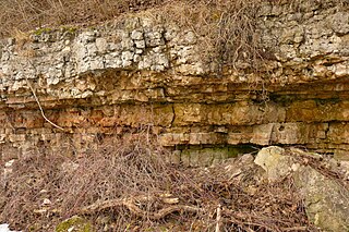
Arkose or arkosic sandstone is a detrital sedimentary rock, specifically a type of sandstone containing at least 25% feldspar. Arkosic sand is sand that is similarly rich in feldspar, and thus the potential precursor of arkose.

<span class="mw-page-title-main">Rapakivi granite</span> Type of igneous rock

Rapakivi granite is a hornblende-biotite granite containing large round crystals of orthoclase each with a rim of oligoclase. The name has come to be used most frequently as a textural term where it implies plagioclase rims around orthoclase in plutonic rocks. Rapakivi is a Finnish compound of "rapa" and "kivi", because the different heat expansion coefficients of the component minerals make exposed rapakivi crumble easily into sand.

<span class="mw-page-title-main">Clastic rock</span> Sedimentary rocks made of mineral or rock fragments

Clastic rocks are composed of fragments, or clasts, of pre-existing minerals and rock. A clast is a fragment of geological detritus, chunks, and smaller grains of rock broken off other rocks by physical weathering. Geologists use the term clastic to refer to sedimentary rocks and particles in sediment transport, whether in suspension or as bed load, and in sediment deposits.

<span class="mw-page-title-main">Roxbury Conglomerate</span>

The Roxbury Conglomerate, also informally known as Roxbury puddingstone, is a name for a rock formation that forms the bedrock underlying most of Roxbury, Massachusetts, now part of the city of Boston. The bedrock formation extends well beyond the limits of Roxbury, underlying part or all of Quincy, Canton, Milton, Dorchester, Dedham, Jamaica Plain, Brighton, Brookline, Newton, Needham, and Dover. It is named for exposures in Roxbury, in the Boston area. It is the Rock of the Commonwealth in Massachusetts.

The Newark Supergroup, also known as the Newark Group, is an assemblage of Upper Triassic and Lower Jurassic sedimentary and volcanic rocks which outcrop intermittently along the east coast of North America. They were deposited in a series of Triassic basins, the Eastern North American rift basins, approximately 220–190 million years ago. The basins are characterized as aborted rifts, with half-graben geometry, developing parallel to the main rift of the Atlantic Ocean which formed as North America began to separate from Africa. Exposures of the Newark Supergroup extend from South Carolina north to Nova Scotia. Related basins are also found underwater in the Bay of Fundy. The group is named for the city of Newark, New Jersey.

<span class="mw-page-title-main">Geology of Tasmania</span>

The geology of Tasmania is complex, with the world's biggest exposure of diabase, or dolerite. The rock record contains representatives of each period of the Neoproterozoic, Paleozoic, Mesozoic and Cenozoic eras. It is one of the few southern hemisphere areas that were glaciated during the Pleistocene with glacial landforms in the higher parts. The west coast region hosts significant mineralisation and numerous active and historic mines.

The Hogland Series are a series of Subjotnian sedimentary rocks exposed in the island of Gogland, the Sommer Islands and the nearby sea bottom in the Gulf of Finland. The series encompass quartz-rich conglomerates and breccias plus some volcanic rocks of mafic composition in the form of lava flows and some more silica-rich igneous rocks including quartz-porphyry. The porphyries, which lie at the top the pile, share their origin with the rapakivi granites found nearby. An exhumed Subjotnian erosion surface is exposed on the island.

The Hallandian-Danopolonian event was an orogeny and thermal event that affected Baltica in the Mesoproterozoic. The event metamorphosed pre-existing rocks and generated magmas that crystallized into granite. The Hallandian-Danopolonian event has been suggested to be responsible for forming an east-west alignment of sedimentary basins hosting Jotnian sediments spanning from eastern Norway, to Lake Ladoga in Russia. The alignment of subsidence is thought to correspond to an ancient back-arc basin parallel to a subduction zone further south.

<span class="mw-page-title-main">Geology of Finland</span>

The geology of Finland is made up of a mix of geologically very young and very old materials. Common rock types are orthogneiss, granite, metavolcanics and metasedimentary rocks. On top of these lies a widespread thin layer of unconsolidated deposits formed in connection to the Quaternary ice ages, for example eskers, till and marine clay. The topographic relief is rather subdued because mountain massifs were worn down to a peneplain long ago.

The Satakunta dyke swarms are a series of dyke swarms, a group of magmatic intrusions, of Mesoproterozoic age in the Bothnian Sea and western and central Finland. They are made up of Subjotnian diabase dikes, associated with rapakivi magmatism. They were most likely formed on the Columbia supercontinent.

<span class="mw-page-title-main">Harry von Eckermann</span>

Harry von Eckermann (1886–1969) was a Swedish industrialist, mineralogist and geologist. His studies were centered around anorogenic alkaline igneous rocks occurring in the Baltic Shield. Following this line he studied the Alnö Complex, Norra Kärr Alkaline Complex and various Rapakivi granites.

The geology of Liberia is largely extremely ancient rock formed between 3.5 billion and 539 million years ago in the Archean and the Neoproterozoic, with some rocks from the past 145 million years near the coast. The country has rich iron resources as well as some diamonds, gold and other minerals in ancient sediment formations weathered to higher concentrations by tropical rainfall.

<span class="mw-page-title-main">Geology of Ghana</span>

The geology of Ghana is primarily very ancient crystalline basement rock, volcanic belts and sedimentary basins, affected by periods of igneous activity and two major orogeny mountain building events. Aside from modern sediments and some rocks formed within the past 541 million years of the Phanerozoic Eon, along the coast, many of the rocks in Ghana formed close to one billion years ago or older leading to five different types of gold deposit formation, which gave the region its former name Gold Coast.

<span class="mw-page-title-main">Geology of Belarus</span>

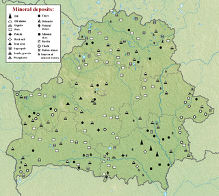
The geology of Belarus began to form more than 2.5 billion years ago in the Precambrian, although many overlying sedimentary units deposited during the Paleozoic and the current Quaternary. Belarus is located in the eastern European plain. From east to west it covers about 650 kilometers while from north to south it covers about 560 kilometers, and the total area is about 207,600 square kilometers. It borders Poland in the north, Lithuania in the northwest, Latvia and Russia in the north, and Ukraine in the south. Belarus has a planar topography with a height of about 160 m above sea level. The highest elevation at 346 meters above sea level is Mt. Dzerzhinskaya, and the lowest point at the height of 80 m is in the Neman River valley.

<span class="mw-page-title-main">Geology of Bosnia and Herzegovina</span>

The geology of Bosnia & Herzegovina is the study of rocks, minerals, water, landforms and geologic history in the country. The oldest rocks exposed at or near the surface date to the Paleozoic and the Precambrian geologic history of the region remains poorly understood. Complex assemblages of flysch, ophiolite, mélange and igneous plutons together with thick sedimentary units are a defining characteristic of the Dinaric Alps, also known as the Dinaride Mountains, which dominate much of the country's landscape.

<span class="mw-page-title-main">Geology of Sweden</span>

The geology of Sweden is the regional study of rocks, minerals, tectonics, natural resources and groundwater in the country. The oldest rocks in Sweden date to more than 2.5 billion years ago in the Precambrian. Complex orogeny mountain building events and other tectonic occurrences built up extensive metamorphic crystalline basement rock that often contains valuable metal deposits throughout much of the country. Metamorphism continued into the Paleozoic after the Snowball Earth glaciation as the continent Baltica collided with an island arc and then the continent Laurentia. Sedimentary rocks are most common in southern Sweden with thick sequences from the last 250 million years underlying Malmö and older marine sedimentary rocks forming the surface of Gotland.

The geology of Bhutan is less well studied than many countries in Asia, together with the broader Eastern Himalayas region. Older Paleozoic and Precambrian rocks often appear mixed together with younger sediments due to the Himalayan orogeny.

<span class="mw-page-title-main">Geology of Latvia</span>

Geology of Latvia includes an ancient Archean and Proterozoic crystalline basement overlain with Neoproterozoic volcanic rocks and numerous sedimentary rock sequences from the Paleozoic, some from the Mesozoic and many from the recent Quaternary past. Latvia is a country in the Baltic region of Northern Europe.

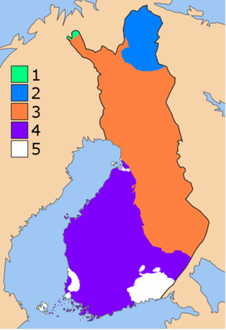
The geology of Åland includes Jotnian age sediments from the Proterozoic, such as sandstone, siltstone, arkose, conglomerate and shale. The islands are underlain by plutonic rocks common of the Svecofennian Domain.

References

  1. 1 2 3 "Jotnian Series". The Great Soviet Encyclopedia . 1979.
  2. 1 2 3 4 5 6 7 8 9 10 11 12 Amantov, A.; Laitakari, I.; Poroshin, Ye (1996). "Jotnian and Postjotnian: Sandstones and diabases in the surroundings of the Gulf of Finland". Geological Survey of Finland, Special Paper . 21: 99–113. Retrieved 27 July 2015.
  3. 1 2 3 4 5 6 7 8 Lehtinen, Martti; Nurmi, Pekka A.; Rämö, Tapani (2005). Precambrian Geology of Finland. Amsterdam: Elsevier. p. 567. ISBN   9780080457598.
  4. 1 2 3 Usaityte, Daiva (2000). "The geology of the southeastern Baltic Sea: a review". Earth-Science Reviews . 50 (3–4): 137–225. Bibcode:2000ESRv...50..137U. doi:10.1016/S0012-8252(00)00002-7.
  5. 1 2 3 4 5 Simonen, Ahti (1980). "The Precambrian in Finland". Geological Survey of Finland Bulletin . 304.
  6. 1 2 Laitakari, I.; Rämö, T.; Suominen, V.; Niin, M.; Stepanov, K.; Amantov, A. (1996). "Subjotnian: Rapakivi granites and related rocks in the Gulf of Finland". Geological Survey of Finland, Special Paper . 21: 59–97. Retrieved 27 July 2015.
  7. 1 2 3 4 5 6 Nagornji, M.A.; Nikolaev, V.G. (2005). "The quasiplatform sediments of the East European Platform". Russian Journal of Earth Sciences . 7 (5): 1–12. doi:10.2205/2005ES000171.
  8. 1 2 3 4 Amantov, Alexey; Hagenfeldt, Stefan; Söderberg, Per (1995). "The Mesoporterozoic to Lower Palaeozoic sedimentary bedrock sequence in the northern Baltic Proper, Åland Sea, Gulf of Finland and Lake Ladoga". Proceedings of the Third Marine Geological Conference "The Baltic". pp. 19–25.
  9. 1 2 Lidmar-Bergström, Karna (1995). "Relief and saprolites through time on the Baltic Shield". Geomorphology . 12 (1): 45–61. Bibcode:1995Geomo..12...45L. doi:10.1016/0169-555X(94)00076-4.
  10. Lidmar-Bergströrm, Karna (1996). "Long term morphotectonic evolution in Sweden". Geomorphology . 16 (1): 33–59. Bibcode:1996Geomo..16...33L. doi:10.1016/0169-555X(95)00083-H.
  11. 1 2 3 4 5 6 7 8 9 10 Paulamäki, Seppo; Kuivamäki, Aimo (2006). "Depositional History and Tectonic Regimes within and in the Margins of the Fennoscandian Shield During the Last 1300 Million Years" (PDF). Working Report. Retrieved 27 July 2015.
  12. 1 2 Rodhe, Agnes (1988). "The dolerite breccia of Tärnö, Late Proterozoic of southern Sweden". Geologiska Föreningen i Stockholm Förhandlingar . 110 (2): 131–142. doi:10.1080/11035898809452652.
  13. 1 2 3 4 Rodhe, Agnes (1986). "Geochemistry and clay mineralogy of argillites in the Late Proterozoic Almesikra group, south Sweden". Geologiska Föreningen i Stockholm Förhandlingar. 107 (3): 175–182. doi:10.1080/11035898809452652 . Retrieved 27 July 2015.
  14. von Eckermann, Harry (1939). "The Weathering of the Nordingrå Gabbro". Geologiska Föreningen i Stockholm Förhandlingar. 61 (4): 490–496. doi:10.1080/11035893909444616.
  15. Korja, A.; Korja, T.; Luosto, U.; Heikkinen, P. (1993). "Seismic and geoelectric evidence for collisional and extensional events in the Fennoscandian Shield – implications for Precambrian crustal evolution". Tectonophysics . 219 (1–3): 129–152. Bibcode:1993Tectp.219..129K. doi:10.1016/0040-1951(93)90292-r.
  16. 1 2 3 Kohonen, J.; Pihlaja, P.; Kujala, H.; Marmo, J. (1993). "Sedimentation of the jotnian Satakunta sandstone, western Finland". Geological Survey of Finland Bulletin . 369.
  17. 1 2 Lundmark, Anders Mattias; Lamminen, Jarkko (2016). "The provenance and setting of the Mesoproterozoic Dala Sandstone, western Sweden, and paleogeographic implications for southwestern Fennoscandia". Precambrian Research . 275: 197–208. Bibcode:2016PreR..275..197L. doi:10.1016/j.precamres.2016.01.003.
  18. 1 2 Paulamäki, Seppo; Paananen, Markku; Elo, Seppo (2004). "Structure and geological evolution of the bedrock of southern Satakunta SW Finland" (PDF). Working Report. Archived from the original (PDF) on 24 September 2015. Retrieved 27 July 2015.
  19. 1 2 3 4 5 Goodwinn, Alan M. (1991). Precambrian Geology. Academic Press. p. 374. ISBN   978-0122898709.
  20. 1 2 Kuptosova, A.V.; Khudoley, A.K.; Davis, W.; Rainbird, R.H.; Kovach, V.P.; Zagornaya, N. Yu (2011). "Age and Provenances of Sandstones from the Riphean Priozersk and Salmi Formations in the Eastern Pasha–Ladoga Basin (Southern Margin of the Baltic Shield)". Stratigraphy and Geological Correlation . 19 (2): 125–140. Bibcode:2011SGC....19..125K. doi:10.1134/S0869593811020067. S2CID   128527997.
  21. 1 2 Baluev, A.S. (2006). "Geodynamics of the Riphean stage in the evolution of the northern passive margin of the East European Craton". Geotectonics . 40 (3): 183–196. Bibcode:2006Geote..40..183B. doi:10.1134/s0016852106030034. S2CID   129043120.
  22. 1 2 3 Gavelin, Sven (1931). "Några iakttagelser över stratigrafi och tektonik inom Almesåkraformationen". Geologiska Föreningen i Stockholm Förhandlingar. 53 (II): 137–149. doi:10.1080/11035893109447092.
  23. Rodhe, Agnes (1987). "Depositional environments and lithostratigraphy of the middle Proterozoic Almesåkra Group, southern Sweden" (PDF). Sveriges Geologiska Undersökning Ca. 69: 1–80 via PaleoArchive.
  24. Tullborg, Eva-Lena; Larson, Sven Åke; Stiberg, Jan-Petter (1996). "Subsidence and uplift of the present land surface in the southeastern part of the Fennoscandian Shield". GFF . 118 (2): 126–128. Bibcode:1996GFF...118..126T. doi:10.1080/11035899609546246.
  25. Berg-Lembke, Eva (1970). "A microscopic study of the Almesåkra quartzitic-doleritic conglomerate". Geologiska Föreningen i Stockholm Förhandlingar . 92: 40–48. doi:10.1080/11035897009451914.
  26. Lundqvist, Thomas. "Dalasandsten". Nationalencyklopedin (in Swedish). Cydonia Development. Retrieved June 22, 2015.
  27. Pulvertaft, T.C.R. (1985). "Aeolian dune and wet interdune sedimentation in the Middle Proterozoic Dala sandstone, Sweden". Sedimentary Geology . 44 (1–2): 93–111. Bibcode:1985SedG...44...93P. doi:10.1016/0037-0738(85)90034-X.
  28. Ogenhall, Erik, Kvarnstensfragment från Lejstaån (PDF) (in Swedish), Swedish National Heritage Board, archived from the original (PDF) on November 19, 2015, retrieved November 18, 2015
  29. 1 2 3 Flodén, Tom; Söderberg, Per; Wickman, Frans E. (1993). "Bjorko, a possible Middle Proterozoic impact structure west of Stockholm, Sweden". GFF. 115 (1): 25–38. doi:10.1080/11035899309454826.
  30. "Gåsholmen". Länsstyrensen Stockholm. Retrieved November 18, 2015.
  31. 1 2 3 Sobral, José María (1913). "Contributions to the Geology of the Nordingrå Region". Geological Magazine. 1 (2): 86. doi:10.1017/S0016756800138026.
  32. 1 2 3 4 5 Bergman, Göran (1980). "Quicksand structures in the Jotnian sandstone of central Sweden". GFF. 102 (2): 111–116. doi:10.1080/11035898009450887.