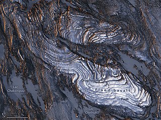
The Mesoproterozoic Era is a geologic era that occurred from 1,600 to 1,000 million years ago. The Mesoproterozoic was the first era of Earth's history for which a fairly definitive geological record survives. Continents existed during the preceding era, but little is known about them. The continental masses of the Mesoproterozoic were more or less the same ones that exist today, although their arrangement on the Earth's surface was different.

The Grenville orogeny was a long-lived Mesoproterozoic mountain-building event associated with the assembly of the supercontinent Rodinia. Its record is a prominent orogenic belt which spans a significant portion of the North American continent, from Labrador to Mexico, as well as to Scotland.

The geology of Australia includes virtually all known rock types, spanning a geological time period of over 3.8 billion years, including some of the oldest rocks on earth. Australia is a continent situated on the Indo-Australian Plate.

The Gascoyne Complex is a terrane of Proterozoic granite and metamorphic rock in the central-western part of Western Australia. The complex outcrops at the exposed western end of the Capricorn Orogen, a 1,000 km-long arcuate belt of folded, faulted and metamorphosed rocks between two Archean cratons; the Pilbara craton to the north and the Yilgarn craton to the south. The Gascoyne Complex is thought to record the collision of these two different Archean continental fragments during the Capricorn Orogeny at 1830–1780 Ma.

The Wyoming Craton is a craton in the west-central United States and western Canada – more specifically, in Montana, Wyoming, southern Alberta, southern Saskatchewan, and parts of northern Utah. Also called the Wyoming Province, it is the initial core of the continental crust of North America.
The Labrador Trough or the New Quebec Orogen is a 1,600 km (994 mi) long and 160 km (99 mi) wide geologic belt in Canada, extending south-southeast from Ungava Bay through Quebec and Labrador.

The Moine Supergroup is a sequence of Neoproterozoic metamorphic rocks that form the dominant outcrop of the Scottish Highlands between the Moine Thrust Belt to the northwest and the Great Glen Fault to the southeast. The sequence is metasedimentary in nature and was metamorphosed and deformed in a series of tectonic events during the Late Proterozoic and Early Paleozoic. It takes its name from A' Mhòine, a peat bog in northern Sutherland.

The Lufilian Arc is part of a system of orogenic belts in southern Africa formed during the Pan-African orogeny, a stage in the formation of the Gondwana supercontinent. It extends across eastern Angola, the Katanga Province of the southern Democratic Republic of the Congo and the northwest of Zambia. The arc is about 800 kilometres (500 mi) long. It has global economic importance owing to its rich deposits of copper and cobalt.
The Hook granite massif is a large formation in central Zambia formed around 550 million years ago during the Pan-African orogeny. It lies in the inner part of the Lufilian arc. Today, the south-western extension of the massif lies under the Kafue National Park.
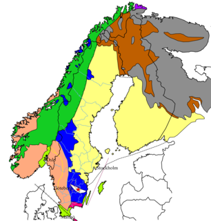
The Sveconorwegian orogeny was an orogenic system active 1140 to 960 million years ago and currently exposed as the Sveconorwegian orogenic belt in southwestern Sweden and southern Norway. In Norway the orogenic belt is exposed southeast of the front of the Caledonian nappe system and in nappe windows. The Sveconorwegian orogen is commonly grouped within the Grenvillian Mesoproterozoic orogens. Contrary to many other known orogenic belts the Sveconorwegian orogens eastern border does not have any known suture zone with ophiolites.
The Transscandinavian Igneous Belt, abbreviated TIB, is one of the major lithological units of the Baltic Shield. It consists of a series of batholiths in Sweden and Norway forming a ca. 1400 km long belt running from Lofoten, Norway, in the north to Blekinge, Sweden, in the south. The Transscandinavian Igneous Belt and its rocks solidified from magma between 1810 and 1650 million years ago during the Mesoproterozoic. The Transscandinavian Igneous Belt was likely formed in an Andean-type geological environment, implying it was once parallel to a destructive plate boundary. The belt was first identified in the 1980s and was referred as the "Transscandinavian Granite-Porphyry Belt". The current name was first applied in 1987.
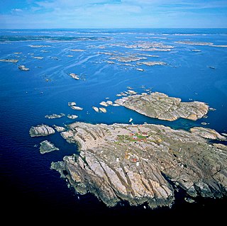
The Kattsund-Koster dyke swarm is a collection of dykes of Mesoproterozoic age in southeastern Norway and the West Coast of Sweden. The most prominent outcrops are in the Koster Islands in Sweden and Kattsund in Norway, hence the name. The dykes are made up of tholeiitic diabase and some dykes of intermediate composition. Some dykes are deformed and metamorphosed into amphibolite. Radiometric dating has shown that the dyke swarm is about 1421 million years old. Geologists have suggested that the dyke swarm is related to extensional tectonics.

The Aravalli Mountain Range is a northeast-southwest trending orogenic belt in the northwest part of India and is part of the Indian Shield that was formed from a series of cratonic collisions. The Aravalli Mountains consist of the Aravalli and Delhi fold belts, and are collectively known as the Aravalli-Delhi orogenic belt. The whole mountain range is about 700 km long. Unlike the much younger Himalayan section nearby, the Aravalli Mountains are believed much older and can be traced back to the Proterozoic Eon. They are arguably the oldest geological feature on Earth. The collision between the Bundelkhand craton and the Marwar craton is believed to be the primary mechanism for the development of the mountain range.
The geology of Malawi formed on extremely ancient crystalline basement rock, which was metamorphosed and intruded by igneous rocks during several orogeny mountain building events in the past one billion years. The rocks of the Karoo Supergroup and newer sedimentary units deposited across much of Malawi in the last 251 million years, in connection with a large rift basin on the supercontinent Gondwana and the more recent rifting that has created the East African Rift, which holds Lake Malawi. The country has extensive mineral reserves, many of them poorly understand or not exploited, including coal, vermiculite, rare earth elements and bauxite.
The geology of Sweden is the regional study of rocks, minerals, tectonics, natural resources and groundwater in the country. The oldest rocks in Sweden date to more than 2.5 billion years ago in the Precambrian. Complex orogeny mountain building events and other tectonic occurrences built up extensive metamorphic crystalline basement rock that often contains valuable metal deposits throughout much of the country. Metamorphism continued into the Paleozoic after the Snowball Earth glaciation as the continent Baltica collided with an island arc and then the continent Laurentia. Sedimentary rocks are most common in southern Sweden with thick sequences from the last 250 million years underlying Malmö and older marine sedimentary rocks forming the surface of Gotland.
The Grenville Province is a tectonically complex region, in Eastern Canada, that contains many different aged accreted terranes from various origins. It exists southeast of the Grenville Front and extends from Labrador southwestern to Lake Huron. It is bounded by the St. Lawrence River/Seaway to the southeast.
The Mangaroon orogeny was an orogenic event in what is now Western Australia between 1.68 and 1.62 billion years ago in the Proterozoic, preserved in the rocks of the large Gascoyne Province.
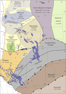
The Mazatzal orogeny was an orogenic event in what is now the Southwestern United States from 1650 to 1600 Mya in the Statherian Period of the Paleoproterozoic. Preserved in the rocks of New Mexico and Arizona, it is interpreted as the collision of the 1700-1600 Mya age Mazatzal island arc terrane with the proto-North American continent. This was the second in a series of orogenies within a long-lived convergent boundary along southern Laurentia that ended with the ca. 1200–1000 Mya Grenville orogeny during the final assembly of the supercontinent Rodinia, which ended an 800-million-year episode of convergent boundary tectonism.

The Picuris orogeny was an orogenic event in what is now the Southwestern United States from 1.43 to 1.3 billion years ago in the Calymmian Period of the Mesoproterozoic. The event is named for the Picuris Mountains in northern New Mexico and interpreted either as the suturing of the Granite-Rhyolite crustal province to the southern margin of the proto-North American continent Laurentia or as the final suturing of the Mazatzal crustal province onto Laurentia. According to the former hypothesis, this was the second in a series of orogenies within a long-lived convergent boundary along southern Laurentia that ended with the ca. 1200–1000 Mya Grenville orogeny during the final assembly of the supercontinent Rodinia, which ended an 800-million-year episode of convergent boundary tectonism.
