Sugar Run Dolomite

Last updated
Sugar Run Dolomite
Stratigraphic range: Silurian
Gerald Farinas Holy Name Cathedral from Street.jpg
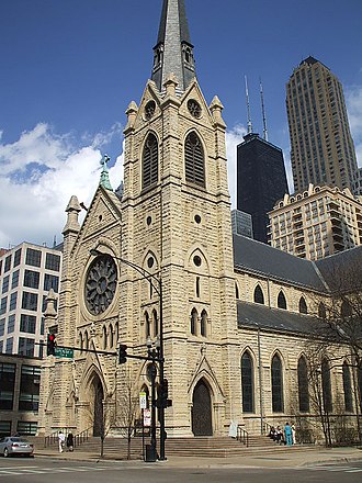
Chicago's Holy Name Cathedral, made of Sugar Run Dolomite, aka "Athens marble" or "Lemont limestone"
Type Formation
Lithology
Primary dolomite
Location
RegionFlag of Illinois.svg  Illinois
CountryFlag of the United States.svg  United States
Type section
Named forSugar Run Stream

The Sugar Run Dolomite is a geologic formation in Illinois. It is a finely-bedded dolomite, preserving fossils dating back to the Silurian period. This formation is named for the Sugar Run stream in Joliet, along which it is well exposed. The dolomite is off-white/grey on freshly cut surfaces, but over time oxidizes to a distinctive cream yellow color, due to trace presence of iron. It is a member of the Niagaran series. [1]

Contents

Use in architecture

This formation has been quarried for building material since the mid-19th century, sometimes sold under the misleading trade name of "Athens marble". It is also known as Joliet or Lemont limestone. [2] It was used widely in the construction of many Chicago homes and buildings from the 1850s-1880s, including the famous Chicago Water Tower. By the 1890s, it fell out of fashion as a building material in favor of more durable Indiana limestone.

See also

Related Research Articles

<span class="mw-page-title-main">Lemont, Illinois</span> Village in Illinois, United States

Lemont is a village located in Cook, DuPage, and Will counties in the U.S. state of Illinois, and is a south-west suburb of Chicago. The population was 17,629 as of the 2020 census. The village is situated on a hillside along the south banks of the Des Plaines River. It overlooks Waterfall Glen's Midwestern Bluff Savanna on the opposite side. Lemont is home to Argonne National Laboratory and other heavy industrial sites, and has a substantial European immigrant population.

<span class="mw-page-title-main">Joliet, Illinois</span> City in Illinois, United States

Joliet is a city in Will and Kendall counties in the U.S. state of Illinois, 35 miles (56 km) southwest of Chicago. It is the county seat of Will County. It had a population of 150,362 at the 2020 census, making it the third-most populous city in Illinois.

<span class="mw-page-title-main">Romeoville, Illinois</span> Village in Illinois, United States

Romeoville is a village in Will County, Illinois, United States. The village is located 26 mi (42 km) southwest of Chicago on the Gateway Wetlands, directly west of the Des Plaines River. Per the 2020 census, the population was 39,863. It is located in the southwest suburban area of Chicago near Interstate 55 and Interstate 355.

<span class="mw-page-title-main">Chicago Water Tower</span> United States historic place

The Chicago Water Tower is a contributing property and landmark in the Old Chicago Water Tower District in Chicago, Illinois, United States, that is listed on the National Register of Historic Places. Built to enclose the tall machinery of a powerful water pump in 1869, it became particularly well known when it survived the Great Chicago Fire of 1871, although the area around it was burnt to the ground.

<span class="mw-page-title-main">Harrodsburg Limestone</span>

The Harrodsburg Limestone is a geologic formation, a member of the Sanders Group of Indiana Limestone, of Mississippian age. It was named for Harrodsburg in southern Monroe County, Indiana by T. C. Hopkins and C. E. Siebenthal. It is made up primarily of calcarenite and calcirudite. It also may include some beds of dolomite and shale.

<span class="mw-page-title-main">Salem Limestone</span>

The Salem Formation is a geologic formation in Illinois, Indiana, Kentucky, and Missouri. It preserves fossils dating back to the Mississippian subperiod. This formation is quarried and used as a building material, known as "Indiana limestone", also called Bedford limestone.

<span class="mw-page-title-main">Laurel Formation (Silurian)</span> Geological formation in Indiana and Kentucky

The Laurel Formation, also known as the Laurel Limestone or the Laurel Dolomite, is a geologic formation in Indiana and Kentucky. It preserves fossils dating back to the Silurian period.

The Grand Tower Limestone is a geologic formation in Illinois. It preserves fossils dating back to the Devonian period.

<span class="mw-page-title-main">Kinzers Formation</span>

The Kinzers Formation is a geologic formation in Pennsylvania. It preserves fossils dating back to the Cambrian Period.

<span class="mw-page-title-main">Tomstown Dolomite</span>

The Tomstown Dolomite or Tomstown Formation is a geologic formation in Maryland, Pennsylvania, Virginia and West Virginia. It preserves fossils dating to the Cambrian Period.

The Lithograph City Formation is a geologic formation in Iowa, part of the Cedar Valley Group. It preserves fossils dating back to the Devonian period. The formation is composed of dolomite and limestone, with many fossils and vugs in the lower part, while the upper part contains few fossils.

The Cedar Valley Formation is a geologic formation in Iowa. It preserves fossils dating back to the Devonian period. No type locality has ever been designated for this formation, but it is best known for limestone and dolomite exposures in and around Johnson County, Iowa. The formation is exposed in numerous road cuts, quarries and valley walls over much of north-east and north-central Iowa.

The Manitou Limestone is a geologic formation in Colorado. It preserves fossils dating back to the Ordovician period.

<span class="mw-page-title-main">Notch Peak Formation</span> Geologic formation in Utah, United States

The Notch Peak Formation is a geologic formation in Utah. It preserves fossils dating back to the Cambrian period.

<span class="mw-page-title-main">Gibraltar Limestone</span>

Gibraltar Limestone consists of greyish-white or pale-gray compact, and sometime finely crystalline, medium to thick bedded limestones and dolomites that locally contain chert seams. This formation comprises about three quarters of the Rock of Gibraltar near the southernmost tip of the Iberian peninsula. Geologists have found various poorly preserved and badly eroded and rolled marine fossils within it. The fossils found in the Gibraltar Limestone include various brachiopods, corals, echinoid fragments, gastropods, pelecypods, and stromatolites. These fossils indicate an Early Jurassic age for the deposition of the Gibraltar Limestone.

Horace Meach Singer was an American businessman and politician from New York. Coming with his father to Lockport, Illinois work on the Illinois & Michigan Canal, Singer rose to become superintendent of repairs. In the course of his work, he came across a large quarry near Lemont, Illinois and established a company to mine it. Singer & Talcott was in operation until 1889. In 1866, Singer served a term in the Illinois House of Representatives, then was elected to the Cook County Board of Commissioners in the 1870s.

The Huntersville Chert or Huntersville Formation is a Devonian geologic formation in the Appalachian region of the United States. It is primarily composed of mottled white, yellow, and dark grey chert, and is separated from the underlying Oriskany Sandstone by an unconformity. The Huntersville Chert is laterally equivalent to the Needmore Shale, which lies north of the New River. It is also laterally equivalent to a sandy limestone unit which is often equated with the Onondaga Limestone. These formations are placed in the Onesquethaw Stage of Appalachian chronostratigraphy, roughly equivalent to the Emsian and Eifelian stages of the broader Devonian system.

Toad Formation, Grayling Formation, and Toad-Grayling Formation are obsolete names for the strata of the Early to Middle Triassic Doig and Montney Formations. They were applied in the foothills and Rocky Mountains of northeastern British Columbia, on the western edge of the Western Canada Sedimentary Basin. Although the names are considered obsolete, their usage persists.

<span class="mw-page-title-main">Spray River Group</span>

The Spray River Group is a stratigraphic unit of Triassic age. It is present on the western edge of the Western Canada Sedimentary Basin in the foothills and Rocky Mountains of western Alberta. It was originally described as the Spray River Formation by E.M. Kindle in 1924 and was later raised to group status. Its type section is located in the Spray River gorge at the southern end of Sulphur Mountain.

<span class="mw-page-title-main">Lemont Central Grade School</span> United States historic place

The Lemont Central Grade School is a former school building at 410 McCarthy Road in Lemont, Illinois. The school was built in 1869 to replace Lemont's first school, which opened in 1836 when the area was still largely rural. Locally quarried limestone was used to construct the school; at the time, limestone production was one of the city's main industries. Architect John Barnes of Joliet designed the Victorian building. As the city's population grew considerably during the construction of the Chicago Sanitary and Ship Canal in the 1890s, an annex was placed on the school in 1896 to accommodate additional students. The school operated until building safety issues forced its closure in 1974; at the time, it was the oldest continuously operating school in the state. The building has since been converted to condominiums.

References

  1. Bradbury, James (1988). Joliet-Lemont Limestone (PDF). Landmarks Preservation Council of Illinois. Retrieved 10 March 2023.
  2. "Limestoned".