Jamesville Colony, South Dakota | |
|---|---|
 Jamesville Colony  Jamesville Colony | |
| Coordinates: 43°06′06″N97°28′54″W / 43.10167°N 97.48167°W | |
| Country | United States |
| State | South Dakota |
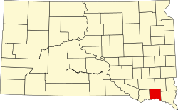
| County | Yankton |
| Area | |
• Total | 0.10 sq mi (0.27 km2) |
| • Land | 0.10 sq mi (0.27 km2) |
| • Water | 0 sq mi (0.00 km2) |
| Elevation | 1,184 ft (361 m) |
| Population | |
• Total | 110 |
| • Density | 1,049.8/sq mi (405.34/km2) |
| Time zone | UTC-6 (Central (CST)) |
| • Summer (DST) | UTC-5 (CDT) |
| ZIP Code | 57067 (Utica) |
| Area code | 605 |
| FIPS code | 46-32388 |
| GNIS feature ID | 2813067 [2] |
Jamesville Colony is a census-designated place (CDP) and Hutterite colony [4] in Yankton County, South Dakota, United States. The population was 110 at the 2020 census. [5] It was first listed as a CDP prior to the 2020 census. [2]
It is in the northwest part of the county, on the north side of the James River. It is 9 miles (14 km) north of Utica and 20 miles (32 km) north-northwest of Yankton, the county seat.