Spink Township | |
---|---|
Township | |
Street in Spink | |
Coordinates: 42°51′07″N96°44′49″W / 42.85194°N 96.74694°W Coordinates: 42°51′07″N96°44′49″W / 42.85194°N 96.74694°W | |
Country | United States |
State | South Dakota |
County | Union |
Population (2000) | |
• Total | 245 |
Time zone | Central (CST) (UTC-6) |
• Summer (DST) | CDT (UTC-5) |
Spink Township is a township in Union County, South Dakota, United States. Its population was 245 at the 2000 census. [1]
A civil township is a widely used unit of local government in the United States that is subordinate to a county. The term town is used in New England, New York, and Wisconsin to refer to the equivalent of the civil township in these states. Specific responsibilities and the degree of autonomy vary based on each state. Civil townships are distinct from survey townships, but in states that have both, the boundaries often coincide and may completely geographically subdivide a county. The U.S. Census Bureau classifies civil townships as minor civil divisions. Currently, there are 20 states with civil townships.
Union County is a county in the U.S. state of South Dakota. As of the 2010 United States Census, the population was 14,399. Its county seat is Elk Point. Originally named Cole County, its name was changed to Union because of Civil War sentiment.
South Dakota is a U.S. state in the Midwestern region of the United States. It is named after the Lakota and Dakota Sioux Native American tribes, who compose a large portion of the population and historically dominated the territory. South Dakota is the seventeenth largest by area, but the fifth smallest by population and the 5th least densely populated of the 50 United States. As the southern part of the former Dakota Territory, South Dakota became a state on November 2, 1889, simultaneously with North Dakota. Pierre is the state capital and Sioux Falls, with a population of about 183,200, is South Dakota's largest city.
Located in western Union County, Spink Township borders the following other townships: [2]
Emmet Township is a township in Union County, South Dakota, United States. The population was 257 at the 2000 census.
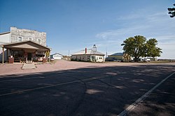
A community, also named Spink, was established in the township in 1871. At its peak, the community was strong enough to compete for the title of county seat. [3]
A county seat is an administrative center, seat of government, or capital city of a county or civil parish. The term is used in Canada, China, Romania, Taiwan and the United States. County towns have a similar function in the United Kingdom and Republic of Ireland, and historically in Jamaica.
Toward the end of the 20th century only a few business remained in the community of Spink. The Spink Cafe was the center of life in the township and was still a place where farmers would gather. Gary's Repair was a place where people could get the truck or tractor a little work and the old Co-Op that went by the name of Spink Oil was the town's gas station. Spink Oil closed in 1997 and today only the Cafe and Gary's Repair remain.
A proposed refinery by Hyperion Refining, LLC is now working to build the nation's first new oil refinery in years in the United States, this proposed refinery has created a large split in the corn and bean farmers of Union County. A few family farms were given money for options on the land that makes up the family farms that have been a part of the county since the late 19th century. This split lead to the formation of the save union county group and attracted a lot of media attention.
Spink County is a county in the U.S. state of South Dakota. As of the 2010 United States Census, the population was 6,415. Its county seat is Redfield. The county was created in 1873, and was organized in 1879 within Dakota Territory.
Davison County is a county in the U.S. state of South Dakota. As of the 2010 United States Census, the population was 19,504. Its county seat is Mitchell. The county was created in 1873 and organized in 1874. It was named for Henry C. Davison, the first settler in the county.
Roxana is a village in Madison County, Illinois, United States. The population was 1,542 at the 2010 census.
Pusheta Township is one of the fourteen townships of Auglaize County, Ohio, United States. The 2010 census found 1,301 people in the township.
Clay Township is one of the fourteen townships of Auglaize County, Ohio, United States. The 2010 census found 817 people in the township.
The Sioux City metropolitan statistical area, otherwise known as Siouxland, as defined by the United States Census Bureau, is an area consisting of five counties in three states – Iowa, Nebraska, and South Dakota, anchored by the city of Sioux City, Iowa. As of the 2010 census, the MSA had a population of 168,825. In the future, Wayne County would be considered by some people and politicians as an additional sixth county.
Allen Township is one of the twelve townships of Ottawa County, Ohio, United States. The 2000 census found 3,591 people in the township, 3,297 of whom lived in the unincorporated portions of the township.
Farmer Township is one of the twelve townships of Defiance County, Ohio, United States. The 2010 census found 963 people in the township.
Valley Township is one of the sixteen townships of Scioto County, Ohio, United States. The 2010 census counted 3,874 people in the township.
York Township is one of the fourteen townships of Morgan County, Ohio, United States. The 2000 census found 958 people in the township.
Clay Township is one of the seventeen townships of Highland County, Ohio, United States. As of the 2010 census the population was 1,431, up from 1,219 at the 2000 census.
Perry Township is one of the nine townships of Montgomery County, Ohio, United States. As of the 2010 census the population was 5,999.
Clay Township is one of the nine townships of Montgomery County, Ohio, United States. As of the 2010 census the population was 8,847.
Barrington Township is one of 29 townships in Cook County, Illinois, USA. As of the 2010 census, its population was 15,636. The northwestern corner of the Cook County panhandle, it is the county's northwesternmost township. It is also by far the least densely populated township in the county, with less than half the population density of the next least Lemont Township.
Cass Township is one of eleven townships in Clay County, Indiana. As of the 2010 census, its population was 347 and it contained 140 housing units.
Lewis Township is one of eleven townships in Clay County, Indiana. As of the 2010 census, its population was 1,464 and it contained 632 housing units.
Brooklyn Township is a township in Lincoln County, South Dakota, United States, in the Sioux Falls metropolitan area. Its population was 233 at the 2000 census.
Cecil Township is a civil township in Bottineau County in the U.S. state of North Dakota. As of the 2000 census, its population was 28.
This South Dakota state location article is a stub. You can help Wikipedia by expanding it. |