Richland, South Dakota

Last updated

Richland
USA South Dakota location map.svg
Red pog.svg
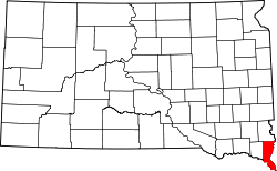
Richland
Location within the state of South Dakota
Usa edcp location map.svg
Red pog.svg
Richland
Richland (the United States)
Coordinates: 42°45′20″N96°38′31″W / 42.75556°N 96.64194°W / 42.75556; -96.64194
Country United States
State South Dakota
County Union
Area
[1]
  Total
5.64 sq mi (14.62 km2)
  Land5.64 sq mi (14.62 km2)
  Water0 sq mi (0.00 km2)
Elevation
[2]
1,161 ft (354 m)
Population
 (2020) [3]
  Total
97
  Density17.2/sq mi (6.63/km2)
Time zone UTC-6 (Central (CST))
  Summer (DST) UTC-5 (CDT)
FIPS code 46-54750
GNIS feature ID2628849 [2]

Richland is a small unincorporated community and census-designated place (CDP) in Union County, South Dakota, United States. The population was 97 at the 2020 census. [4]

Contents

History

In 1861, the community was founded by and named after Milton M. Rich of Chicago. Mr. Rich was reported to have dreamed of building a community below the bluffs. However, it was also reported that Mr. Rich disagreed with railroad officials on how to divide the site of the town. The dispute was never resolved; and as a result, the railroad was deflected to Sioux City, Iowa after reaching Le Mars, Iowa.

Demographics

Historical population
CensusPop.Note
2020 97
U.S. Decennial Census [5]

References

  1. "ArcGIS REST Services Directory". United States Census Bureau. Retrieved October 15, 2022.
  2. 1 2 U.S. Geological Survey Geographic Names Information System: Richland, South Dakota
  3. "Census Population API". United States Census Bureau. Retrieved October 15, 2022.
  4. "U.S. Census Bureau: Richland CDP, South Dakota". www.census.gov. United States Census Bureau. Retrieved May 6, 2022.
  5. "Census of Population and Housing". Census.gov. Retrieved June 4, 2016.