Emmet Township, Union County, South Dakota

Last updated
Emmet Township
USA South Dakota location map.svg
Red pog.svg
Emmet Township
Location within the state of South Dakota
Coordinates: 42°58′59″N96°43′30″W / 42.98306°N 96.72500°W / 42.98306; -96.72500 Coordinates: 42°58′59″N96°43′30″W / 42.98306°N 96.72500°W / 42.98306; -96.72500
Country United States
State South Dakota
County Union
Area
  Total36.00 sq mi (93.24 km2)
  Land36.00 sq mi (93.24 km2)
  Water0.0 sq mi (0.0 km2)
Population
 (2000)
  Total257
  Density7.1/sq mi (2.8/km2)
Time zone UTC-6 (Central (CST))
  Summer (DST) UTC-5 (CDT)
FIPS code 19500

Emmet Township is a township in Union County, South Dakota, United States. The population was 257 at the 2000 census.

Contents

Geography

According to the United States Census Bureau, the township has a total area of 36.0 square miles (93.24 km2), all land.

Demographics

At the 2000 census, [1] there were 257 people, 97 households and 76 families residing in the township. The population density was /km2 (/sq mi). There were 100 housing units at an average density of /km2 (/sq mi). The racial makeup of the township was 99.2% White and 0.8% Asian. Hispanic or Latino of any race were 0.4% of the population.

There were 97 households, of which 39.2% had children under the age of 18 living with them, 72.2% were married couples living together, 3.1% had a female householder with no husband present, and 21.6% were non-families. 20.6% of all households were made up of individuals, and 7.2% had someone living alone who was 65 years of age or older. The average household size was 2.65 and the average family size was 3.08.

History

Emmet Township was organized in 1900 from parts of the neighboring Spink and Prairie Townships in Union County.

Related Research Articles

Union County, South Dakota U.S. county in South Dakota

Union County is a county in the U.S. state of South Dakota. As of the 2010 United States Census, the population was 14,399. Its county seat is Elk Point. Originally named Cole County, its name was changed to Union because of Civil War sentiment.

Emmet County, Iowa U.S. county in Iowa

Emmet County is a county located in the U.S. state of Iowa. As of the 2010 census, the population was 10,302. The county seat is Estherville.

Mapleton Township, Blue Earth County, Minnesota Township in Minnesota, United States

Mapleton Township is a township in Blue Earth County, Minnesota, United States. The population was 310 as of the 2000 census.

Eureka Township, Dakota County, Minnesota Township in Minnesota, United States

Eureka Township is an urban township in Dakota County, Minnesota, United States. The population was 1,490 at the 2000 census.

Ravenna Township, Dakota County, Minnesota Township in Minnesota, United States

Ravenna Township is a township in Dakota County, Minnesota, United States. The population was 2,336 at the 2010 census.

Sciota Township, Dakota County, Minnesota Township in Minnesota, United States

Sciota Township is a township in Dakota County, Minnesota, United States. The population was 285 at the 2000 census. The ghost town of Lewiston was located in the township.

Vermillion Township, Dakota County, Minnesota Township in Minnesota, United States

Vermillion Township is a township in Dakota County, Minnesota, United States. The population was 1,243 at the 2000 census.

Emmet Township, Renville County, Minnesota Township in Minnesota, United States

Emmet Township is a township in Renville County, Minnesota, United States. The population was 259 at the 2000 census.

Moranville Township, Roseau County, Minnesota Township in Minnesota, United States

Moranville Township is a township in Roseau County, Minnesota, United States. The population was 940 at the 2000 census.

Elizabeth Township, Allegheny County, Pennsylvania Township in Pennsylvania, United States

Elizabeth Township is a township in Allegheny County, Pennsylvania, United States. The population was 13,271 at the 2010 census. Elizabeth Township was one of the original seven townships of Allegheny County.

Monroe Township, Bedford County, Pennsylvania Township in Pennsylvania, United States

Monroe Township is a township in Bedford County, Pennsylvania, United States. The population was 1,336 at the 2010 census.

Douglass Township, Berks County, Pennsylvania Township in Pennsylvania, United States

Douglass Township is a township in Berks County, Pennsylvania, United States. The population was 3,306 at the 2010 census.

Haines Township, Centre County, Pennsylvania Township in Pennsylvania, United States

Haines Township is a township in Centre County, Pennsylvania, United States. It is part of the State College, Pennsylvania Metropolitan Statistical Area. The population was 1,564 at the 2010 census.

Harborcreek Township, Erie County, Pennsylvania Township in Pennsylvania, United States

Harborcreek Township is a township in Erie County, Pennsylvania, United States. The population was 17,234 at the 2010 census, up from 15,178 at the 2000 census. It is part of the Erie Metropolitan Statistical Area.

Portage Township, Potter County, Pennsylvania Township in Pennsylvania, United States

Portage Township is a township in Potter County, Pennsylvania, United States. The population was 223 at the 2000 census.

Liberty Township, Tioga County, Pennsylvania Township in Pennsylvania, United States

Liberty Township is a township in Tioga County, Pennsylvania, in the United States. The population was 1,042 at the 2010 census.

Union Township, Union County, Pennsylvania Township in Pennsylvania, United States

Union Township is a township in Union County, Pennsylvania, United States. The population was 1,427 at the 2000 census. Part of Shikellamy State Park is in Union Township.

Allen, South Dakota CDP in South Dakota, United States

Allen is a census-designated place on the Pine Ridge Indian Reservation in Bennett County, South Dakota, United States, that was named for the Allen Township (civil township, which it encompasses. As of the 2010 census, the CDP had a population of 420. It is considered the poorest place in the United States. It is one of two places which are closest to the North American continental pole of inaccessibility.

Tyndall, South Dakota City in South Dakota, United States

Tyndall is a city in and the county seat of Bon Homme County, South Dakota. The population was 1,067 at the 2010 census.

Hecla, South Dakota City in South Dakota, United States

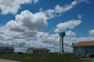
Hecla is a city in Brown County, South Dakota, United States, located only a few miles south of the North Dakota border. The population was 227 at the 2010 census. State Highway 37 runs along the east side of town.

References

  1. "U.S. Census website". United States Census Bureau . Retrieved 2008-01-31.