Creston, Iowa

Last updated

Creston, Iowa
City
Creston, IA.jpg
Union County Iowa Incorporated and Unincorporated areas Creston Highlighted.svg
Location of Creston, Iowa
Coordinates: 41°03′35″N94°21′54″W / 41.05972°N 94.36500°W / 41.05972; -94.36500 [1]
CountryFlag of the United States (23px).png  United States
StateFlag of Iowa.svg  Iowa
County Union
Established1869
Government
  MayorClayton Waylon
Area
[2]
  Total5.25 sq mi (13.60 km2)
  Land5.19 sq mi (13.44 km2)
  Water0.06 sq mi (0.16 km2)
Elevation
[3]
1,283 ft (391 m)
Population
 (2020)
  Total7,536
  Density1,452.30/sq mi (560.78/km2)
Time zone UTC-6 (Central (CST))
  Summer (DST) UTC-5 (CDT)
ZIP code
50801
Area code 641
FIPS code 19-17265
GNIS feature ID467666 [3]
Website www.crestoniowa.gov

Creston is a city in and the county seat of Union County, Iowa. [4] The population was 7,536 at the time of the 2020 Census. [5]

Contents

History

Creston, 1908 Creston Iowa (1908).jpg
Creston, 1908
Former CB&Q depot, constructed in 1899, now used as City Hall and Amtrak station West end old station.jpg
Former CB&Q depot, constructed in 1899, now used as City Hall and Amtrak station

Creston was originally settled in 1868 as a survey camp for the Burlington and Missouri Railroad. It was named for the fact that it was on the crest of the railroad line between the Missouri and Mississippi river basins. The area was developed largely for agriculture, with related industries accompanying it. Creston had a flour mill in the early decades of the 20th century. The town was officially established in 1869 and incorporated in 1871.

Creston was chosen as the division point for the railroad, who built machine shops, a roundhouse, and a construction camp in the new town. Railroad employees, including African Americans, were recruited from Chicago and other major cities to work in Creston. The Chicago, Burlington and Quincy Railroad (CB&Q) opened a new station in Creston in 1899. The three-story, yellow brick Creston station is in the French Provincial style, with a red-tiled mansard roof. [6]

Creston's economy and population were affected during the mid-20th century by a reduction in passenger train service and decline in railroad employment. The old machine shop building was destroyed by a tornado in 1946 and the remainder of the roundhouse burned down in 1981. The CB&Q station served passengers for 69 years before being renovated in 1978 to serve as city hall.

The railroad, now BNSF Railway, continues to be a major hauler of grain and coal in the region and uses Creston as a crew change point: Creston-based crews operate trains between Creston and Lincoln, Nebraska, while crews from Galesburg, Illinois and Lincoln stay in Creston before returning home.

Creston is served by Amtrak's daily Chicago–San Francisco Bay Area California Zephyr . Amtrak has used Creston's historic CB&Q station since 2019. [7] [8]

2012 tornado

Creston was hit by an EF2 tornado on April 14, 2012. The tornado caused considerable damage to the hospital, community college, Kingdom Hall of Jehovah's Witnesses, and the high school. The town's tornado sirens did not sound, catching people off guard. Patients at the hospital were transferred to other local hospitals. The college suffered roof and window damage to its dorms and students were transferred to local hotels for the rest of the school semester. Fourteen people suffered minor injuries; there were no deaths. [9] The Greater Regional Medical Center was two weeks from an open house to unveil a major renovation when it was severely damaged by the tornado. One year after the tornado and $10 million in renovations later, the hospital was fully restored. [10]

Geography

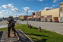
Creston is located on U.S. Route 34 in southwest Iowa, approximately 55 miles (90 km) southwest of Des Moines and 80 miles (130 km) east of Omaha, Nebraska. According to the United States Census Bureau, the city has a total area of 5.25 square miles (13.60 km2), of which 5.19 square miles (13.44 km2) is land and 0.06 square miles (0.16 km2) is water. [11]

McKinley Lake lies within a large, multi-purpose municipal park within the city limits, and three additional recreational lakes are located within seven miles of Creston: Green Valley State Park, Summit Lake, Twelve Mile Lake and Three Mile Recreation Area.

Climate

According to the Köppen Climate Classification system, Creston has a hot-summer humid continental climate, abbreviated "Dfa" on climate maps.

Climate data for Creston, Iowa, 1991–2020 normals, extremes 1905–present
MonthJanFebMarAprMayJunJulAugSepOctNovDecYear
Record high °F (°C)66
(19)
78
(26)
87
(31)
93
(34)
103
(39)
102
(39)
111
(44)
111
(44)
103
(39)
92
(33)
80
(27)
71
(22)
111
(44)
Mean maximum °F (°C)52.9
(11.6)
58.1
(14.5)
72.9
(22.7)
82.2
(27.9)
87.2
(30.7)
91.4
(33.0)
94.3
(34.6)
93.0
(33.9)
89.6
(32.0)
83.2
(28.4)
68.5
(20.3)
56.9
(13.8)
95.7
(35.4)
Mean daily maximum °F (°C)30.5
(−0.8)
35.1
(1.7)
48.7
(9.3)
61.2
(16.2)
71.3
(21.8)
80.9
(27.2)
84.7
(29.3)
83.0
(28.3)
76.4
(24.7)
64.1
(17.8)
48.4
(9.1)
35.7
(2.1)
60.0
(15.6)
Daily mean °F (°C)20.5
(−6.4)
24.5
(−4.2)
37.1
(2.8)
48.6
(9.2)
60.1
(15.6)
70.1
(21.2)
74.0
(23.3)
71.8
(22.1)
64.0
(17.8)
51.7
(10.9)
37.3
(2.9)
25.8
(−3.4)
48.8
(9.3)
Mean daily minimum °F (°C)10.6
(−11.9)
13.8
(−10.1)
25.5
(−3.6)
36.1
(2.3)
48.8
(9.3)
59.4
(15.2)
63.2
(17.3)
60.7
(15.9)
51.6
(10.9)
39.3
(4.1)
26.2
(−3.2)
16.0
(−8.9)
37.6
(3.1)
Mean minimum °F (°C)−9.8
(−23.2)
−4.6
(−20.3)
6.7
(−14.1)
22.0
(−5.6)
35.8
(2.1)
48.4
(9.1)
53.5
(11.9)
51.8
(11.0)
37.6
(3.1)
24.8
(−4.0)
10.1
(−12.2)
−2.8
(−19.3)
−13.7
(−25.4)
Record low °F (°C)−31
(−35)
−26
(−32)
−20
(−29)
7
(−14)
23
(−5)
37
(3)
39
(4)
39
(4)
24
(−4)
2
(−17)
−18
(−28)
−26
(−32)
−31
(−35)
Average precipitation inches (mm)1.04
(26)
1.46
(37)
2.53
(64)
3.74
(95)
5.15
(131)
5.17
(131)
4.46
(113)
4.23
(107)
3.70
(94)
2.79
(71)
2.14
(54)
1.48
(38)
37.89
(961)
Average snowfall inches (cm)6.1
(15)
9.1
(23)
3.5
(8.9)
0.8
(2.0)
0.0
(0.0)
0.0
(0.0)
0.0
(0.0)
0.0
(0.0)
0.0
(0.0)
0.1
(0.25)
1.8
(4.6)
5.6
(14)
27.0
(69)
Average precipitation days (≥ 0.01 in)4.15.08.110.612.311.39.18.98.18.06.35.297.0
Average snowy days (≥ 0.1 in)3.63.91.60.40.00.00.00.00.00.21.13.414.2
Source 1: NOAA (precip days, snow/snow days 19812010) [12] [13]
Source 2: National Weather Service [14]

Demographics

Historical populations
YearPop.±%
1870 411    
1880 5,081+1136.3%
1890 7,200+41.7%
1900 7,752+7.7%
1910 6,924−10.7%
1920 8,034+16.0%
1930 8,615+7.2%
1940 8,033−6.8%
1950 8,317+3.5%
1960 7,667−7.8%
1970 8,234+7.4%
1980 8,429+2.4%
1990 7,911−6.1%
2000 7,597−4.0%
2010 7,834+3.1%
2020 7,536−3.8%
Source: "U.S. Census website". United States Census Bureau . Retrieved March 29, 2020. and Iowa Data Center
Source:
U.S. Decennial Census [15] [5]

2010 census

As of the census [16] of 2010, there were 7,834 people, 3,378 households, and 1,973 families living in the city. The population density was 1,509.4 inhabitants per square mile (582.8/km2). There were 3,773 housing units at an average density of 727.0 per square mile (280.7/km2). The racial makeup of the city was 96.0% White, 1.0% African American, 0.3% Native American, 0.6% Asian, 0.8% from other races, and 1.2% from two or more races. Hispanic or Latino of any race were 2.3% of the population.

There were 3,378 households, of which 28.1% had children under the age of 18 living with them, 42.5% were married couples living together, 11.5% had a female householder with no husband present, 4.4% had a male householder with no wife present, and 41.6% were non-families. 35.7% of all households were made up of individuals, and 15.3% had someone living alone who was 65 years of age or older. The average household size was 2.23 and the average family size was 2.87.

The median age in the city was 38.8 years. 23.1% of residents were under the age of 18; 10.5% were between the ages of 18 and 24; 22.9% were from 25 to 44; 25.5% were from 45 to 64; and 17.9% were 65 years of age or older. The gender makeup of the city was 47.7% male and 52.3% female.

2000 census

As of the census [17] of 2000, there were 7,597 people, 3,346 households, and 1,974 families living in the city. The population density was 1,496.2 inhabitants per square mile (577.7/km2). There were 3,598 housing units at an average density of 708.6 per square mile (273.6/km2). The racial makeup of the city was 98.13% White, 0.34% African American, 0.22% Native American, 0.34% Asian, 0.38% from other races, and 0.58% from two or more races. Hispanic or Latino of any race were 1.26% of the population.

There were 3,346 households, out of which 26.4% had children under the age of 18 living with them, 46.5% were married couples living together, 9.9% had a female householder with no husband present, and 41.0% were non-families. 35.7% of all households were made up of individuals, and 16.0% had someone living alone who was 65 years of age or older. The average household size was 2.20 and the average family size was 2.86.

Age spread: 22.6% under the age of 18, 10.4% from 18 to 24, 25.0% from 25 to 44, 22.0% from 45 to 64, and 20.0% who were 65 years of age or older. The median age was 39 years. For every 100 females, there were 86.7 males. For every 100 females age 18 and over, there were 83.3 males.

The median income for a household in the city was $29,831, and the median income for a family was $41,003. Males had a median income of $27,580 versus $20,172 for females. The per capita income for the city was $16,411. About 7.0% of families and 11.5% of the population were below the poverty line, including 13.6% of those under age 18 and 8.3% of those age 65 or over.

Education

Creston is served by the Creston Community School District: [18]

Private Schools in Creston include:

Colleges

Notable people

Related Research Articles

<span class="mw-page-title-main">Adair, Iowa</span> City in Iowa, United States

Adair is a city in Adair and Guthrie counties of Iowa in the United States. The population was 791 at the 2020 census.

<span class="mw-page-title-main">Prescott, Iowa</span> City in Iowa, United States

Prescott is a city in Prescott Township, Adams County, Iowa, United States. The population was 191 at the time of the 2020 census.

<span class="mw-page-title-main">Rathbun, Iowa</span> City in Iowa, USA

Rathbun is a city in Appanoose County, Iowa, United States. The population was 43 at the time of the 2020 census.

<span class="mw-page-title-main">Sheldahl, Iowa</span> City in Iowa, United States

Sheldahl is a city in Polk, Boone, and Story counties in the U.S. state of Iowa. The population was 297 at the time of the 2020 census.

<span class="mw-page-title-main">Atlantic, Iowa</span> City in Iowa, United States

Atlantic is a city in and the county seat of Cass County, Iowa, United States, located along the East Nishnabotna River. The population was 6,792 in the 2020 census, a decline from the 7,257 population in 2000.

<span class="mw-page-title-main">De Soto, Iowa</span> City in Iowa, United States

De Soto is a city in Dallas County, Iowa, United States. The population was 915 at the time of the 2020 census. It is part of the Des Moines–West Des Moines Metropolitan Statistical Area.

<span class="mw-page-title-main">Waukee, Iowa</span> City in Iowa, United States

Waukee is a city in Dallas County, Iowa, United States. The population was 23,940 at the time of the 2020 U.S. Census. It is part of the Des Moines – West Des Moines Metropolitan Statistical Area.

<span class="mw-page-title-main">Guthrie Center, Iowa</span> City in Iowa, United States

Guthrie Center is a city in Guthrie County, Iowa, United States, along the South Raccoon River. The population was 1,593 at the time of the 2020 census. It is the county seat of Guthrie County.

<span class="mw-page-title-main">Steamboat Rock, Iowa</span> City in Iowa, United States

Steamboat Rock is a city in Hardin County, Iowa, United States. The population was 264 at the time of the 2020 census.

<span class="mw-page-title-main">Bradgate, Iowa</span> City in Iowa, United States

Bradgate is a city in Humboldt County, Iowa, United States, at the conjunction of Sections 5, 6, 7, and 8 of Avery Township, and rests near the banks of the West Fork of the Des Moines River. The population was 75 in the 2020 census, a decline from 101 in 2000.

<span class="mw-page-title-main">Winterset, Iowa</span> City in Iowa, United States

Winterset is a city in and the county seat of Madison County, Iowa. The population was 5,353 at the time of the 2020 census.

<span class="mw-page-title-main">Knoxville, Iowa</span> City in Iowa, United States

Knoxville is a city in Marion County, Iowa, United States. The population was 7,595 at the time of the 2020 census, an increase from 7,313 in the 2010 census. It is the county seat of Marion County. Knoxville is home of the National Sprint Car Hall of Fame & Museum, located next to the famous Knoxville Raceway dirt track.

<span class="mw-page-title-main">Pacific Junction, Iowa</span> City in Iowa, United States

Pacific Junction is a city in Mills County, Iowa, United States. The population was 96 at the time of the 2020 census.

<span class="mw-page-title-main">Bondurant, Iowa</span> City in Iowa, United States

Bondurant is a city in Polk County, Iowa, United States. The population was 7,365 in the 2020 census, an increase of 90.8% from the 3,860 population in 2010. It is part of the Des Moines–West Des Moines metropolitan statistical area.

<span class="mw-page-title-main">Johnston, Iowa</span> City in Iowa, United States

Johnston is a city in Polk County, Iowa, United States. The population was 24,064 in the 2020 census, a large increase from the 8,649 population in 2000. It is part of the Des Moines–West Des Moines Metropolitan Statistical Area.

<span class="mw-page-title-main">Beaconsfield, Iowa</span> City in Iowa, United States

Beaconsfield is a city in Ringgold County, Iowa, United States. The population was 15 in the 2020 census, unchanged from 2010 and an increase from 11 in 2000. In the 2000 census Beaconsfield was the least populated incorporated city in Iowa; with the increase in the 2020 census, it is now the second smallest, after Le Roy.

<span class="mw-page-title-main">Bedford, Iowa</span> City in Iowa, United States

Bedford is a city in Taylor County, Iowa, United States. The population was 1,508 at the 2020 census. It is the county seat of Taylor County. Lake of Three Fires State Park is located several miles northeast of Bedford.

<span class="mw-page-title-main">Ackworth, Iowa</span> City in Iowa, United States

Ackworth is a city in Warren County, Iowa, United States. The population was 115 at the 2020 census.

<span class="mw-page-title-main">Norwalk, Iowa</span> City in Iowa, United States

Norwalk is a city in Warren County, with some small portions extending into Polk County, in the U.S. state of Iowa. The population was 12,799 at the time of the 2020 census. The city is part of the Des Moines metropolitan area and is located just south of the Des Moines International Airport.

<span class="mw-page-title-main">Allerton, Iowa</span> City in Iowa, United States

Allerton is a city in Wayne County, Iowa. The population was 430 at the time of the 2020 census.

References

  1. "US Gazetteer files: 2010, 2000, and 1990". United States Census Bureau. February 12, 2011. Retrieved April 23, 2011.
  2. "2020 U.S. Gazetteer Files". United States Census Bureau. Retrieved March 16, 2022.
  3. 1 2 U.S. Geological Survey Geographic Names Information System: Creston, Iowa
  4. "Find a County". National Association of Counties. Archived from the original on May 31, 2011. Retrieved June 7, 2011.
  5. 1 2 "2020 Census State Redistricting Data". census.gov. United states Census Bureau. Retrieved August 12, 2021.
  6. "City Hall", Creston, Iowa website
  7. , Amtrak
  8. Edwards, Luke (August 15, 2019). "Waiting room restored". Creston News . Retrieved April 6, 2020.
  9. "Storm hits Iowa hospital; tornado warning issued for Wichita". CNN. April 15, 2012.
  10. "GRMC Responds, Recovers from Tornado with community support" [ permanent dead link ], Creston News-Advertiser, April 12, 2013
  11. "US Gazetteer files 2010". United States Census Bureau. Archived from the original on January 25, 2012. Retrieved May 11, 2012.
  12. "U.S. Climate Normals Quick Access – Station: Creston 2 SW, IA (19912020)". National Oceanic and Atmospheric Administration. Retrieved July 24, 2022.
  13. "U.S. Climate Normals Quick Access – Station: Creston 2 SW, IA (19812010)". National Oceanic and Atmospheric Administration. Retrieved May 26, 2023.
  14. "NOAA Online Weather Data". National Weather Service. Retrieved July 24, 2022.
  15. "Census of Population and Housing". Census.gov. Retrieved June 4, 2015.
  16. "U.S. Census website". United States Census Bureau . Retrieved May 11, 2012.
  17. "U.S. Census website". United States Census Bureau . Retrieved January 31, 2008.
  18. "Creston Archived April 27, 2018, at the Wayback Machine ." Iowa Department of Education. Retrieved July 30, 2018.
  19. "Walter Cunningham NASA Astronaut(former)". NASA . Retrieved September 10, 2011.
  20. "John JR Robinson". DRUMMERWORLD. Retrieved September 10, 2011.