The Bureau of Land Management (BLM) is an agency within the United States Department of the Interior responsible for administering U.S. federal lands. Headquartered in Washington, D.C., the BLM oversees more than 247.3 million acres (1,001,000 km2) of land, or one-eighth of the United States's total landmass.
In the United States, a territory is any extent of region under the sovereign jurisdiction of the federal government of the United States, including all waters. The United States asserts sovereign rights for exploring, exploiting, conserving, and managing its territory. This extent of territory is all the area belonging to, and under the dominion of, the United States federal government for administrative and other purposes. The United States total territory includes a subset of political divisions.
In all modern states, a portion of land is held by central or local governments. This is called public land, state land, or Crown land. The system of tenure of public land, and the terminology used, varies between countries. The following examples illustrate some of the range.
A land patent is a form of letters patent assigning official ownership of a particular tract of land that has gone through various legally-prescribed processes like surveying and documentation, followed by the letter's signing, sealing, and publishing in public records, made by a sovereign entity. While land patents are still issued by governments to indicate property is privately held, they are also often used by sovereign citizens and similar groups in illegitimate attempts to gain unlawful possession of property, or avoid taxes and foreclosure.
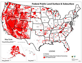
Federal lands are publicly owned lands in the United States managed by the federal government. Pursuant to the Property Clause of the United States Constitution, Congress has the power to retain, buy, sell, and regulate federal lands, such as by limiting cattle grazing on them. These powers have been recognized in a long series of United States Supreme Court decisions.

The Taylor Grazing Act of 1934 is a United States federal law that provides for the regulation of grazing on the public lands to improve rangeland conditions and regulate their use.
The Federal Land Policy and Management Act (FLPMA) is a United States federal law that governs the way in which the public lands administered by the Bureau of Land Management are managed. The law was enacted in 1976 by the 94th Congress and is found in the United States Code under Title 43. The Federal Land Policy and Management Act phased out homesteading in the United States by repealing the pre-existing Homestead Acts.
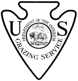
The United States Grazing Service (USGS) was established in 1934 as part of the Taylor Grazing Act. This act was designed to control the destruction of public land due to overgrazing, which had become a problem across western states like Colorado, Wyoming and Montana. The USGS oversees grazing on these lands and regulates the amount of livestock that can be grazed to ensure that the land remains healthy and productive. The USGS also serves as an advocate for ranchers, helping them access permits, utilize water rights, comply with local regulations, and even negotiate grazing leases on public lands.
Kleppe v. New Mexico, 426 U.S. 529 (1976), was a United States Supreme Court decision that unanimously held the Wild and Free-Roaming Horses and Burros Act of 1971, passed in 1971 by the United States Congress to protect these animals from "capture, branding, harassment, or death", to be a constitutional exercise of congressional power. In February 1974, the New Mexico Livestock Board rounded up and sold 19 unbranded burros from Bureau of Land Management (BLM) land. When the BLM demanded the animals' return, the state filed suit claiming that the Wild Free-Roaming Horses and Burros Act was unconstitutional, claiming the federal government did not have the power to control animals in federal lands unless they were items in interstate commerce or causing damage to the public lands.

Kathleen Burton Clarke is an American politician, who served as the national director of the United States Bureau of Land Management from 2001 to 2006. Clarke was the first woman to serve in this role.
The Wild and Free-Roaming Horses and Burros Act of 1971 (WFRHBA), is an Act of Congress, signed into law by President Richard M. Nixon on December 18, 1971. The act covered the management, protection and study of "unbranded and unclaimed horses and burros on public lands in the United States."

Management of free-roaming feral and semi-feral horses, on various public or tribal lands in North America is accomplished under the authority of law, either by the government of jurisdiction or efforts of private groups. In western Canada, management is a provincial matter, with several associations and societies helping to manage wild horses in British Columbia and Alberta. In Nova Scotia, and various locations in the United States, management is under the jurisdiction of various federal agencies. The largest population of free-roaming horses is found in the Western United States. Here, most of them are protected under the Wild and Free-Roaming Horses and Burros Act of 1971 (WFRH&BA), and their management is primarily undertaken by the Bureau of Land Management (BLM), but also by the U. S. Forest Service (USFS)
The Powell Shooting Range Land Conveyance Act is a bill that would transfer some land that is current managed by the Bureau of Land Management (BLM) to the Powell Recreation District in Powell, Wyoming for use as a shooting range. A total of 322 acres of land would be conveyed. The bill would require the Powell Recreation District to pay all of the administrative costs associated with the transfer. The bill passed in both the United States Senate and the United States House of Representatives during the 113th United States Congress. The land in question has been used as a shooting range since 1980.
The Federal Lands Jobs and Energy Security Act is a bill that would require the Bureau of Land Management (BLM) to establish certain fees for activities related to the development of oil and gas on federal lands. A portion of those amounts along with a portion of fees from renewable energy projects on federal lands would be available to the agency, subject to appropriation, to cover the costs of activities aimed at increasing energy development on federal lands. The bill also would exempt lawsuits related to energy production on federal lands from the Equal Access to Justice Act (EAJA). In addition, the legislation would require the BLM to offer for sale at least 25 percent of onshore federal lands nominated by firms for oil and gas leasing. It was introduced in the United States House of Representatives during the 113th United States Congress. President Barack Obama threatened to veto the bill on November 19, 2013.
Grazing rights in Nevada covers a number of rangeland Federal and state laws and regulations applicable to the state of Nevada. Rangelands are distinguished from pasture lands because they grow primarily native vegetation, rather than plants established by humans. Ranchers may lease or obtain permits to use portions of this public rangeland and pay a fee based on the number and type of livestock and the period for which they are on the land.
General Land Office Easements were legal mechanisms which created right of way to ensure future access through, and to the interior of, lots or parcels created by the U.S. Small Tract Act of 1938,.

The Sabinoso Wilderness is a 29,855 acres (120.82 km2) area in San Miguel County, New Mexico. The US Bureau of Land Management owns and administers the wilderness area. The semi-arid wilderness includes few natural resources but has a diverse geology, as well as a range of plant and animal species.
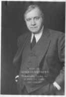
Fred W. Johnson was an American government official who served as the first director of the Bureau of Land Management from 1946 to 1948. Johnson had previously served as the final commissioner of the United States General Land Office, from 1933 until 1946.
The Interior Board of Land Appeals (IBLA) is an appellate review body that exercises the delegated authority of the United States secretary of the interior to issue final decisions for the United States Department of the Interior.
A register was the top official for a district land office of the United States General Land Office. Registers were nominated by the president, with approval of the senate.