Goodings Grove, Illinois

Last updated
Goodings Grove
USA Illinois location map.svg
Red pog.svg
Goodings Grove
Location of Goodings Grove within Illinois
Coordinates: 41°37′34″N87°56′26″W / 41.62611°N 87.94056°W / 41.62611; -87.94056 Coordinates: 41°37′34″N87°56′26″W / 41.62611°N 87.94056°W / 41.62611; -87.94056
CountryUnited States
StateIllinois
County Will
Area
  Total9.4 sq mi (24 km2)
Elevation
[1]
758 ft (231 m)
Population
 (2000)
  Total17,084
  Density1,800/sq mi (700/km2)
Time zone UTC-6 (CST)
  Summer (DST) UTC-5 (CDT)
Area codes 815, 779

Goodings Grove was a census-designated place in northern Will County, Illinois, United States. The population was 17,084 at the 2000 census. It ceased to exist as an entity upon the incorporation of the village of Homer Glen, Illinois in 2001.

Contents

Geography

Goodings Grove was located at 41°37′34″N87°56′26″W / 41.62611°N 87.94056°W / 41.62611; -87.94056 (41.626164, -87.940460). [2]

According to the United States Census Bureau, the CDP had a total area of 9.4 square miles (24 km2), of which 0.11% is water.

Demographics

As of the census [3] of 2000, there were 17,084 people, 5,109 households, and 4,649 families residing in the CDP. The population density was 1,813.6 inhabitants per square mile (700.2/km2). There were 5,183 housing units at an average density of 550.2 per square mile (212.4/km2). The racial makeup of the CDP was 96.49% White, 0.20% African American, 0.01% Native American, 1.74% Asian, 0.59% from other races, and 0.97% from two or more races. Hispanic or Latino of any race were 3.52% of the population.

There were 5,109 households, out of which 49.6% had children under the age of 18 living with them, 84.1% were married couples living together, 4.9% had a female householder with no husband present, and 9.0% were non-families. 7.3% of all households were made up of individuals, and 2.8% had someone living alone who was 65 years of age or older. The average household size was 3.34 and the average family size was 3.53.

In the CDP, the population was spread out, with 31.1% under the age of 18, 7.8% from 18 to 24, 28.2% from 25 to 44, 27.3% from 45 to 64, and 5.8% who were 65 years of age or older. The median age was 36 years. For every 100 females, there were 100.4 males. For every 100 females age 18 and over, there were 96.9 males.

The median income for a household in the CDP was $84,484, and the median income for a family was $88,101. Males had a median income of $57,017 versus $34,583 for females. The per capita income for the CDP was $29,452. About 1.5% of families and 1.8% of the population were below the poverty line, including 3.1% of those under age 18 and 1.2% of those age 65 or over.

Related Research Articles

Rock Creek, Alabama CDP in Alabama, United States

Rock Creek is a census-designated place in Jefferson County, Alabama, United States. Its location is northwest of Hueytown. At the 2020 census, the population was 1,471. This area was damaged by an F5 tornado on April 8, 1998. An EF2 tornado struck northwest from here on January 23, 2012.

New Market, Alabama Census-designated place in Alabama, United States

New Market is an unincorporated community and census-designated place (CDP) in Madison County, Alabama, United States, and is included in the Huntsville-Decatur Combined Statistical Area. As of the 2020 census, the population of the CDP was 1,543. Although it was the first area settled in Madison County, the town has never been incorporated.

<span class="mw-page-title-main">Lutak, Alaska</span> Census-designated place in Alaska, United States

Lutak is a census-designated place (CDP) in Haines Borough, Alaska, United States. The population was 49 at the 2010 census, up from 39 in 2000.

Lake Hamilton, Arkansas Census-designated place in Arkansas, United States

Lake Hamilton is a census-designated place (CDP) in Garland County, Arkansas, United States. It is part of the Hot Springs Metropolitan Statistical Area. The population was 2,135 at the 2010 census. It is named after Lake Hamilton, one of the area's man-made lakes.

Freedom, California Census-designated place in California, United States

Freedom is a census-designated place (CDP) in Santa Cruz County, California, United States. The population was 3,070 at the 2010 census.

<span class="mw-page-title-main">Myrtle Grove, Florida</span> Census-designated place in Florida, United States

Myrtle Grove is a census-designated place (CDP) in Escambia County, Florida, United States. The population was 15,870 at the 2010 census. It is part of the Pensacola–Ferry Pass–Brent Metropolitan Statistical Area.

<span class="mw-page-title-main">Galena, Indiana</span> Census-designated place in Indiana, United States

Galena is a census-designated place (CDP) in Floyd County, Indiana, United States. The population was 1,818 at the 2010 census. The CDP includes the town of Galena as well as the nearby town of Floyds Knobs and their immediate surroundings.

North Falmouth, Massachusetts Census-designated place in Massachusetts, United States

North Falmouth is a census-designated place (CDP) in the town of Falmouth in Barnstable County, Massachusetts, United States. The population was 3,084 at the 2010 census.

Mattapoisett Center, Massachusetts Census-designated place in Massachusetts, United States

Mattapoisett Center is a census-designated place (CDP) in the town of Mattapoisett in Plymouth County, Massachusetts, United States. The population was 2,915 at the 2010 census.

Naytahwaush, Minnesota Census-designated place in Minnesota, US

Naytahwaush is a census-designated place (CDP) in Mahnomen County, Minnesota, United States. The population was 578 at the 2010 census.

Presidential Lakes Estates, New Jersey Census-designated place in New Jersey, United States

Presidential Lakes Estates is an unincorporated community and census-designated place (CDP) located within Pemberton Township, in Burlington County, New Jersey, United States. As of the 2010 United States Census, the CDP's population was 2,365.

Ashland, New Jersey Census-designated place in New Jersey, United States

Ashland is an unincorporated community and census-designated place (CDP) located within Cherry Hill, in Camden County, New Jersey, United States. As of the 2010 United States Census, the CDP's population was 8,302.

Lake Katrine, New York CDP in New York, United States

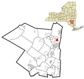
Lake Katrine is a hamlet in Ulster County, New York, United States. The population was 2,397 at the 2010 census.

Pleasant Grove, Ohio CDP in Ohio, United States

Pleasant Grove is a census-designated place (CDP) in Muskingum County, Ohio, United States. The population was 2,016 at the 2000 census.

Shady Grove, Cherokee County, Oklahoma Census-designated place in Oklahoma, United States

Shady Grove is an unincorporated community and census-designated place (CDP) in Cherokee County, Oklahoma, United States. The population was 556 at the 2010 census. This is not to be confused with the similarly-named Shady Grove in McIntosh County, or the Shady Grove in Pawnee County.

Julian, Pennsylvania Census-designated place in Pennsylvania, United States

Julian is an unincorporated community and census-designated place (CDP) in Centre County, Pennsylvania, United States. It is part of the State College, Pennsylvania Metropolitan Statistical Area. The population was 152 at the 2010 census. Most locals pronounce the name "Joo-lee-ānn".

Marion Township, Centre County, Pennsylvania Township in Pennsylvania, United States

Marion Township is a township in Centre County, Pennsylvania, United States. It is part of the State College, Pennsylvania Metropolitan Statistical Area. The population was 1,196 at the 2020 census, down from 1,224 at the 2010 census. Part of Bald Eagle State Park is in Marion Township.

Eyers Grove, Pennsylvania Census-designated place in Pennsylvania, United States

Eyers Grove is a census-designated place in Columbia County, Pennsylvania, United States. The population was 105 at the 2010 census. It is part of the Bloomsburg–Berwick Micropolitan Statistical Area.

<span class="mw-page-title-main">East Hill-Meridian, Washington</span> Former CDP in Washington, United States

East Hill-Meridian is a former census-designated place (CDP) in King County, Washington. The population was 29,878 at the time of the 2010 census. The majority of the census area is now within the limits of Kent and Renton.

Plattekill (CDP), New York CDP in New York, United States

Plattekill is a hamlet in Ulster County, New York, United States. The population was 1,260 at the 2010 census. The community, as is the town, is named after a local stream, the Platte Kill.

References

  1. "USGS detail on Goodings Grove" . Retrieved 2007-11-11.
  2. "US Gazetteer files: 2010, 2000, and 1990". United States Census Bureau. 2011-02-12. Retrieved 2011-04-23.
  3. "U.S. Census website". United States Census Bureau . Retrieved 2008-01-31.