Millington, Illinois

Last updated

Millington, Illinois
Kendall County Illinois Incorporated and Unincorporated areas Millington Highlighted.svg
Location of Millington in Kendall County, Illinois
Illinois in United States (US48).svg
Location of Illinois in the United States
Coordinates: 41°33′44″N88°36′08″W / 41.56222°N 88.60222°W / 41.56222; -88.60222 [1]
CountryUnited States
StateIllinois
Counties Kendall, LaSalle
Townships Fox, Mission, Northville
Government
  Village presidentDouglas Holley
Area
[2]
  Total0.76 sq mi (1.98 km2)
  Land0.71 sq mi (1.83 km2)
  Water0.06 sq mi (0.14 km2)
Elevation
[1]
564 ft (172 m)
Population
 (2020)
  Total617
  Density871.47/sq mi (336.32/km2)
Time zone UTC-6 (CST)
  Summer (DST) UTC-5 (CDT)
ZIP code
60537
Area code 815
FIPS code 17-49308
GNIS feature ID2399361 [1]
Wikimedia CommonsMillington, Illinois
Website www.millingtonil.com

Millington is a village in Kendall and LaSalle counties in the U.S. state of Illinois. The population was 617 at the 2020 census, [3] down from 665 at the 2010 census. [4]

Contents

The Kendall County portion of Millington is part of the Chicago Naperville Joliet Metropolitan Statistical Area, while the LaSalle County portion is part of the Ottawa Micropolitan Statistical Area.

Geography

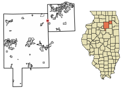
Millington is in the western part of Kendall County and the northeastern part of LaSalle County at 41°33′43″N88°35′59″W / 41.562020°N 88.599606°W / 41.562020; -88.599606 . [5] In the 2010 census, 245 of Millington's residents lived in Kendall County [6] and 420 lived in LaSalle County. [7] [8] The actual boundary line of the counties is not clearly defined in town, although a road farther south, named "Sandhill Road" in Kendall County and "N. 4201 Rd." in LaSalle County, clearly shows the county line, especially in the winter, as LaSalle County is slower in plowing the road, while the Kendall County portion is somewhat clear.[ citation needed ]

According to the 2021 census gazetteer files, Millington has a total area of 0.76 square miles (1.97 km2), of which 0.71 square miles (1.84 km2) (or 92.79%) is land and 0.06 square miles (0.16 km2) (or 7.21%) is water. [9] It lies mostly on the southeast side of the Fox River, except for a neighborhood along Belle Rive Drive on the northwest side of the river.

Millington is 2 miles (3 km) north of Newark, 7 miles (11 km) south of Sandwich, and 11 miles (18 km) southwest of Yorkville. Joliet is 30 miles (48 km) to the east, and Aurora is 22 miles (35 km) to the northeast.

Demographics

Historical population
CensusPop.Note
1880 255
1890 30118.0%
1900 286−5.0%
1910 223−22.0%
1920 212−4.9%
1930 208−1.9%
1940 24819.2%
1950 2708.9%
1960 30914.4%
1970 3389.4%
1980 43929.9%
1990 4707.1%
2000 458−2.6%
2010 66545.2%
2020 617−7.2%
U.S. Decennial Census [10]

As of the census [11] of 2020, there were 617 people, 257 households, and 190 families residing in the village. The population density was 811.8 inhabitants per square mile (313.4/km2). There were 240 housing units at an average density of 315.8 per square mile (121.9/km2). The racial makeup of the village was 92.54% White, 0.16% African American, 0% Asian, 0.97% American Indian and Alaska Native, and 4.86% from two or more races. Hispanic or Latino of any race were 4.38% of the population.

There were 257 households, out of which 40.1% had children under the age of 18 living with them, 53.3% were married couples living together, 4.3% had a female householder with no husband present, and 10.0% were non-families. 24.1% of all households were made up of individuals, and 5.4% had someone living alone who was 65 years of age or older. The average household size was 2.58 and the average family size was 3.01.

In the village, the population was spread out, with 26.4% under the age of 18, 5.7% from 18 to 24, 28.8% from 25 to 44, 33.2% from 45 to 64, and 10.0% who were 65 years of age or older. The median age was 37.5 years. For every 100 females, there were 145.2 males. For every 100 females age 18 and over, there were 144.9 males.

The median income for a household in the village was $74.063, and the median income for a family was $86,500. Males had a median income of $63,026 versus $32,500 for females. The per capita income for the village was $36,357. About 1.1% of families and 3.8% of the population were below the poverty line, including 3.5% of those under age 18 and 3.0% of those age 65 or over.

The community is served by the Newark Fire Department, the Kendall County Sheriff's Department (through the Newark Police), the Sheridan Volunteer Fire Protection District (for ambulance service).

The community is also served by Newark School District, (south of Pine Street in the community), Sandwich District 430 (north side of Pine Street to the border with LaSalle County and north of the Fox River), and Community District School District #2 (west of the LaSalle County Line, and south of the Fox River).

History

In the fall of 1834 the nucleus of the village was begun when George Markley and Samuel Jackson staked out the first claim and built a log cabin on the river bank near the house where Sam Adams now lives(408 Church St.). They claimed some 600 acres on both sides of the river and the next spring the dam to furnish waterpower for a sawmill which was also begun in 1835. The mill was located on the south side of the river.

Samuel Jackson came from Pennsylvania. A loyal Democrat, he supported the presidential campaign of Andrew Jackson with such vigor that he wore the nickname of “General” for the rest of his life. He was a member of the County Commissioners Court of Kendall County when the new court buildings were built. He married Eunice Tubbs.

The Millington Newark Cemetery is located on Church Street on the southern edge of the village, on top of the hill overlooking the village center. It is populated with over 3,000 graves, including a Revolutionary War veteran buried on the north side.

Samuel’s brother, Jesse Jackson, came from Pennsylvania for a visit and was so pleased with the location that he bought out Markley’s interest and moved his family here in 1836. His was the first frame house in Millington. That year the sawmill was completed and put into operation.

Related Research Articles

<span class="mw-page-title-main">Dalzell, Illinois</span> Village in Illinois, United States

Dalzell is a village in Bureau and LaSalle counties in the U.S. state of Illinois. The population was 663 at the 2020 census, down from 717 at the 2010 census. It is part of the Ottawa Micropolitan Statistical Area. Dalzell was founded on November 24, 1903 and certified on February 11, 1904.

<span class="mw-page-title-main">Aviston, Illinois</span> Village in Illinois, United States

Aviston is a village in Clinton County, Illinois, United States. The population was 2,340 at the 2020 census, up from 1,945 at the 2010 census.

<span class="mw-page-title-main">Bartelso, Illinois</span> Village in Illinois, United States

Bartelso is a village in Clinton County, Illinois, United States. The population was 635 at the 2020 census, up from 595 at the 2010 census.

<span class="mw-page-title-main">Damiansville, Illinois</span> Village in Illinois, United States

Damiansville is a village in Clinton County, Illinois, United States. The population was 564 at the 2020 census, up from 491 at the 2010 census.

<span class="mw-page-title-main">Minooka, Illinois</span> Village in Illinois, United States

Minooka is a village in Grundy, Kendall, and Will counties, Illinois, United States. The population was 10,924 at the 2010 census, up from 3,971 at the 2000 census. The village is part of the Chicago metropolitan area. The Chicago, Rock Island and Pacific Railroad served the town at Minooka Station.

<span class="mw-page-title-main">Basco, Illinois</span> Village in Illinois, United States

Basco is a village in Bear Creek Township, Hancock County, Illinois, United States. The population was 98 at the 2010 census.

<span class="mw-page-title-main">Bowen, Illinois</span> Village in Illinois, United States

Bowen is a village in southeast Hancock County, Illinois, United States. The population was 494 at the 2010 census.

<span class="mw-page-title-main">Elvaston, Illinois</span> Village in Illinois, United States

Elvaston is a village in Hancock County, Illinois, United States. The population was 165 at the 2010 census, an increase from 152 in 2000.

<span class="mw-page-title-main">Ferris, Illinois</span> Village in Illinois, United States

Ferris is a village in Hancock County, Illinois, United States. The population was 156 at the 2010 census.

<span class="mw-page-title-main">Elizabethtown, Illinois</span> Village in Illinois, United States

Elizabethtown is a village in and the county seat of Hardin County, Illinois, United States, along the Ohio River. The population was 299 at the 2010 census, down from 348 at the 2000 census. It is the least-populous county seat in the state.

<span class="mw-page-title-main">Gulfport, Illinois</span> Village in Illinois, United States

Gulfport is a village in Henderson County, Illinois, United States. As of the 2010 census, the village population was 54, down from 207 at the 2000 census. It is part of the Burlington, IA–IL Micropolitan Statistical Area. The village was completely submerged, save the roofs of some homes and buildings, by a levee break during the flood of 2008.

<span class="mw-page-title-main">Lomax, Illinois</span> Village in Illinois, United States

Lomax is a village in Henderson County, Illinois, United States. The population was 454 at the 2010 census, a decline from 477 in 2000. It is part of the Burlington, IA–IL Micropolitan Statistical Area.

<span class="mw-page-title-main">Stronghurst, Illinois</span> Village in Illinois, United States

Stronghurst is a village in Henderson County, Illinois, United States. The population was 883 at the 2010 census. It is part of the Burlington, IA–IL Micropolitan Statistical Area.

<span class="mw-page-title-main">Aroma Park, Illinois</span> Village in Illinois, United States

Aroma Park is a village in Kankakee County, Illinois, United States, along the Kankakee River opposite the mouth of the Iroquois River. Aroma Park is a suburb of the city of Kankakee. Aroma Park's population was 743 at the 2010 census, down from 821 at the 2000 census. It is included in the Kankakee-Bradley, Illinois Metropolitan Statistical Area.

<span class="mw-page-title-main">Irwin, Illinois</span> Village in Illinois, United States

Irwin is a village in Kankakee County, Illinois, United States. The population was 74 at the 2010 census, down from 92 at the 2000 census. It is included in the Kankakee-Bradley, Illinois Metropolitan Statistical Area.

<span class="mw-page-title-main">Newark, Illinois</span> Village in Illinois, United States

Newark is a village in Kendall County, Illinois, United States. The population was 992 at the 2010 census, up from 887 at the 2000 census.

<span class="mw-page-title-main">Henderson, Illinois</span> Village in Illinois, United States

Henderson is a village in Knox County, Illinois, United States. The population was 255 at the 2010 census, down from 319 at the 2000 census. It is part of the Galesburg Micropolitan Statistical Area.

<span class="mw-page-title-main">St. Augustine, Illinois</span> Village in Illinois, United States

St. Augustine or Saint Augustine is a village in Knox County, Illinois, United States. The population was 120 at the 2010 census, down from 152 at the 2000 census. It is part of the Galesburg Micropolitan Statistical Area.

<span class="mw-page-title-main">Kangley, Illinois</span> Village in Illinois, United States

Kangley is a village in LaSalle County, Illinois, United States. The population was 235 at the 2020 census, down from 251 at the 2010 census. It is part of the Ottawa Micropolitan Statistical Area. It is a part of the geographic region known as Streatorland.

<span class="mw-page-title-main">Indian Creek, Illinois</span> Village in Illinois, United States

Indian Creek is a village in Vernon Township, Lake County, Illinois, United States. It is part of the Chicago metropolitan area. Per the 2020 census, the population was 536. Police services are provided by Lake County Sheriff and fire/EMS services by the Countryside Fire Protection District.

References

  1. 1 2 3 U.S. Geological Survey Geographic Names Information System: Millington, Illinois
  2. "2020 U.S. Gazetteer Files". United States Census Bureau. Retrieved March 15, 2022.
  3. "Explore Census Data". data.census.gov. Retrieved June 6, 2022.
  4. "Geographic Identifiers: 2010 Demographic Profile Data (G001): Millington village, Illinois". American Factfinder. U.S. Census Bureau. Retrieved February 20, 2019.[ dead link ]
  5. "US Gazetteer files: 2010, 2000, and 1990". United States Census Bureau. February 12, 2011. Retrieved April 23, 2011.
  6. "Geographic Identifiers: 2010 Demographic Profile Data (G001): Millington village (part), Fox Township, Kendall County, Illinois". American Factfinder. U.S. Census Bureau. Archived from the original on February 14, 2020. Retrieved February 20, 2019.
  7. "Geographic Identifiers: 2010 Demographic Profile Data (G001): Millington village (part), Mission Township, LaSalle County, Illinois". American Factfinder. U.S. Census Bureau. Archived from the original on February 14, 2020. Retrieved February 20, 2019.
  8. "Geographic Identifiers: 2010 Demographic Profile Data (G001): Millington village (part), Northville Township, LaSalle County, Illinois". American Factfinder. U.S. Census Bureau. Archived from the original on February 14, 2020. Retrieved February 20, 2019.
  9. Bureau, US Census. "Gazetteer Files". Census.gov. Retrieved June 29, 2022.
  10. "Census of Population and Housing". Census.gov. Retrieved June 4, 2015.
  11. "Explore Census Data". data.census.gov. Retrieved June 6, 2022.