Rutland, Illinois

Last updated

Rutland, Illinois
LaSalle County Illinois Incorporated and Unincorporated areas Rutland Highlighted.svg
Location in LaSalle County, Illinois
Illinois in United States (US48).svg
Location of Illinois in the United States
Coordinates: 40°59′02″N89°02′29″W / 40.98389°N 89.04139°W / 40.98389; -89.04139 [1]
CountryUnited States
StateIllinois
County LaSalle
Township Groveland
Government
  Village presidentDaniel Krischel
Area
[2]
  Total0.69 sq mi (1.80 km2)
  Land0.69 sq mi (1.80 km2)
  Water0.00 sq mi (0.00 km2)
Elevation
[1]
702 ft (214 m)
Population
 (2020)
  Total259
  Density373.20/sq mi (144.03/km2)
Time zone UTC-6 (CST)
  Summer (DST) UTC-5 (CDT)
ZIP code
61358
Area code 815
FIPS code 17-66443
GNIS feature ID2399151 [1]
Wikimedia CommonsRutland, Illinois

Rutland is a village in LaSalle County, Illinois, United States. It is part of the Ottawa Micropolitan Statistical Area. As of the 2020 census, the population was 259, down from 318 at the 2010 census. [3]

Contents

The village was named after Rutland, Vermont. [4]

History

The village was founded as "New Rutland" in 1855 when approximately 200 members of the Vermont Emigration Association paid $10 each for a plot of land. [5] [6] The original location of the town-site was exclusively within LaSalle county. However, an additional ten blocks of land were added October 20, 1856, that was located primarily in adjacent Marshall County. [6]

2021 Village Hall Fire

On the morning of October 15, 2021, a fire was reported across the street from the village's 100 block of Northwest Front Street. Fifteen fire departments responded, including Streator, along with multiple ambulances and law enforcement personal. [7] The fire is currently being investaged as an arson attack.

Geography

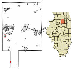
Rutland is located in the southern panhandle of LaSalle County. The western border of the village is the LaSalle/Marshall County line. Approximately five blocks of developed land extend west into Marshall County, outside the village limits.

Illinois Route 251 follows the county line and the western border of the village. It leads north 5 miles (8 km) to Wenona and south 7 miles (11 km) to Minonk in Woodford County. Interstate 39 passes 0.5 miles (0.80 km) of the village limits, but there is no direct access to Rutland. The nearest exits are 3 miles (5 km) to the north and 5 miles (8 km) to the south.

According to the 2021 census gazetteer files, Rutland has a total area of 0.69 square miles (1.79 km2), all land. [8]

Demographics

Historical population
CensusPop.Note
1870 412
1880 402−2.4%
1890 50926.6%
1900 89475.6%
1910 754−15.7%
1920 618−18.0%
1930 495−19.9%
1940 462−6.7%
1950 4865.2%
1960 5094.7%
1970 437−14.1%
1980 48711.4%
1990 391−19.7%
2000 354−9.5%
2010 318−10.2%
2020 259−18.6%
U.S. Decennial Census [9]

As of the 2020 census [10] there were 259 people, 124 households, and 79 families residing in the village. The population density was 373.20 inhabitants per square mile (144.09/km2). There were 132 housing units at an average density of 190.20 per square mile (73.44/km2). The racial makeup of the village was 89.58% White, 3.09% African American, 1.54% from other races, and 5.79% from two or more races. Hispanic or Latino of any race were 6.18% of the population.

There were 124 households, out of which 24.2% had children under the age of 18 living with them, 45.97% were married couples living together, 9.68% had a female householder with no husband present, and 36.29% were non-families. 36.29% of all households were made up of individuals, and 25.00% had someone living alone who was 65 years of age or older. The average household size was 2.96 and the average family size was 2.25.

The village's age distribution consisted of 30.1% under the age of 18, 3.6% from 18 to 24, 20.1% from 25 to 44, 23.6% from 45 to 64, and 22.6% who were 65 years of age or older. The median age was 38.9 years. For every 100 females, there were 84.8 males. For every 100 females age 18 and over, there were 85.7 males.

The median income for a household in the village was $43,750, and the median income for a family was $56,719. Males had a median income of $50,625 versus $9,938 for females. The per capita income for the village was $22,763. About 15.2% of families and 25.1% of the population were below the poverty line, including 41.7% of those under age 18 and 1.6% of those age 65 or over.

Related Research Articles

<span class="mw-page-title-main">Bondville, Illinois</span> Village in Illinois, United States

Bondville is a village in Champaign County, Illinois, United States. The population was 388 at the 2020 census.

<span class="mw-page-title-main">Wilmington, Greene County, Illinois</span> Village in Illinois, United States

Wilmington (Patterson) is a village in Greene County, Illinois, United States. The population was 142 at the 2010 census.

<span class="mw-page-title-main">Hampshire, Illinois</span> Village in Illinois, United States

Hampshire is a village in Kane County, Illinois, United States. As of the 2020 census it had a population of 7,667.

<span class="mw-page-title-main">Millington, Illinois</span> Village in Illinois, United States

Millington is a village in Kendall and LaSalle counties in the U.S. state of Illinois. The population was 617 at the 2020 census, down from 665 at the 2010 census.

<span class="mw-page-title-main">Cedar Point, Illinois</span> Village in Illinois, United States

Cedar Point is a village in LaSalle County, Illinois, United States. The population was 266 at the 2020 census, down from 277 at the 2010 census. It is part of the Ottawa Micropolitan Statistical Area. North of town was the Cedar Point Mine, which operated from 1906 to 1924.

<span class="mw-page-title-main">Dana, Illinois</span> Village in Illinois, United States

Dana is a village in LaSalle County, Illinois, United States. As of the 2010 census, the village had a total population of 159, down from 171 in 2000. It is part of the Ottawa Micropolitan Statistical Area, as well as a part of the geographic region known as Streatorland.

<span class="mw-page-title-main">Kangley, Illinois</span> Village in Illinois, United States

Kangley is a village in LaSalle County, Illinois, United States. The population was 235 at the 2020 census, down from 251 at the 2010 census. It is part of the Ottawa Micropolitan Statistical Area. It is a part of the geographic region known as Streatorland.

<span class="mw-page-title-main">Leland, Illinois</span> Village in Illinois, United States

Leland is a village in LaSalle County, Illinois, United States. The population was 951 at the 2020 census. It is part of the Ottawa Micropolitan Statistical Area.

<span class="mw-page-title-main">Leonore, Illinois</span> Village in Illinois, United States

Leonore is a village in LaSalle County, Illinois, United States. The population was 121 at the 2020 census. It is part of the Ottawa Micropolitan Statistical Area.

<span class="mw-page-title-main">Lostant, Illinois</span> Village in Illinois, United States

Lostant is a village in LaSalle County, Illinois, United States. The population was 423 at the 2020 census, down from 498 at the 2010 census. It is part of the Ottawa Micropolitan Statistical Area.

<span class="mw-page-title-main">Naplate, Illinois</span> Village in Illinois, United States

Naplate is a village in LaSalle County, Illinois, United States. The population was 412 at the 2020 census. It is part of the Ottawa Micropolitan Statistical Area.

<span class="mw-page-title-main">Ransom, Illinois</span> Village in Illinois, United States

Ransom is a village in LaSalle County, Illinois, United States. The population was 308 at the 2020 census, down from 384 at the 2010 census. It is part of the Ottawa Micropolitan Statistical Area. It is part of the subregion known as Streatorland.

<span class="mw-page-title-main">Tonica, Illinois</span> Village in LaSalle County, Illinois

Tonica is a village in LaSalle County, Illinois, United States. The population was 749 at the 2020 census, down from 768 at the 2010 census. It is part of the Ottawa Micropolitan Statistical Area.

<span class="mw-page-title-main">Troy Grove, Illinois</span> Village in Illinois, United States

Troy Grove is a village in LaSalle County, Illinois, United States. The population was 225 at the 2020 census, down from 250 at the 2010 census. It is part of the Ottawa, IL Micropolitan Statistical Area.

<span class="mw-page-title-main">Chesterfield, Illinois</span> Village in Illinois, United States

Chesterfield is a village in Macoupin County, Illinois, United States. The population was 170 at the 2020 census.

<span class="mw-page-title-main">Shipman, Illinois</span> Village in Illinois, United States

Shipman is a village in Macoupin County, Illinois, United States. The population was 511 at the 2020 census, down from 624 in 2010.

<span class="mw-page-title-main">La Rose, Illinois</span> Village in Illinois, United States

La Rose is a village in Bell Plain Township, Marshall County, Illinois, United States. The population was 98 at the 2020 census, down from 144 in 2010. It is part of the Peoria Metropolitan Statistical Area.

<span class="mw-page-title-main">Sparland, Illinois</span> Village in Illinois, United States

Sparland is a village in Marshall County, Illinois, United States. The population was 366 at the 2020 census, down from 406 in 2010. It is part of the Peoria Metropolitan Statistical Area.

<span class="mw-page-title-main">Varna, Illinois</span> Village in Illinois, United States

Varna is a village in Marshall County, Illinois, United States. The population was 375 at the 2020 census. It is part of the Peoria Metropolitan Statistical Area.

<span class="mw-page-title-main">Wenona, Illinois</span> City in Illinois, United States

Wenona is a city in Marshall and LaSalle counties in the U.S. state of Illinois. The population was 974 at the 2020 census.

References

  1. 1 2 3 U.S. Geological Survey Geographic Names Information System: Rutland, Illinois
  2. "2020 U.S. Gazetteer Files". United States Census Bureau. Retrieved March 15, 2022.
  3. "Profile of General Population and Housing Characteristics: 2010 Census Summary File 1 (DP-1), Rutland village, Illinois". American FactFinder. U.S. Census Bureau. Archived from the original on February 13, 2020. Retrieved January 3, 2020.
  4. Illinois Central Magazine. Illinois Central Railroad Company. 1922. p. 43.
  5. Callary, Edward (2008). Placenames of Illinois. University of Illinois Press. p. 307. ISBN   9780252090707.
  6. 1 2 Ford, Henry Allen. "Town of New Rutland: History". Transcribed 04 Feb 2012 from History of Putnam and Marshall Counties, by Henry Allen Ford, 1860. Marshall County IL GenWeb. Retrieved February 16, 2014.
  7. "Arson suspected in multi-alarm Rutland blaze". WGLC.
  8. Bureau, US Census. "Gazetteer Files". Census.gov. Retrieved June 29, 2022.
  9. "Census of Population and Housing". Census.gov. Retrieved June 4, 2015.
  10. "Explore Census Data". data.census.gov. Retrieved June 28, 2022.