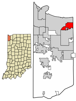
City of Lake Station, Indiana | |
---|---|
Motto: "Our Home Town" | |
Coordinates: 41°34′26″N87°15′05″W / 41.57389°N 87.25139°W | |
Country | United States |
State | Indiana |
County | Lake |
Government | |
• Mayor | Bill Carroll (D) [1] |
Area | |
• Total | 8.42 sq mi (21.82 km2) |
• Land | 8.29 sq mi (21.47 km2) |
• Water | 0.13 sq mi (0.35 km2) |
Elevation | 594 ft (181 m) |
Population (2020) | |
• Total | 13,235 |
• Density | 1,596.50/sq mi (616.44/km2) |
Time zone | UTC-6 (CST) |
• Summer (DST) | UTC-5 (CDT) |
ZIP code | 46405 |
Area code | 219 |
FIPS code | 18-41535 [4] |
GNIS feature ID | 2395602 [3] |
Website | www |
Lake Station is a city in Lake County, Indiana, United States. The population was 13,235 at the 2020 census.
Initially, the site of modern Lake Station was the starting point of two indigenous trails leading to Fort Dearborn. [5] Later it became an early stagecoach depot stop, as the Fort Dearborn-Detroit Stagecoach Route passed through the site during the wet season. [5] The location became known as Lake Station as far back as 1851 when it began to serve as a depot, the western terminus of the Michigan Central Railroad [5] (on what would later become its Detroit to Chicago line). This was the first train station in Lake County. [5] The Michigan Central Railroad built a park and railroad shops around its two-story depot. [5] A year later, in April 1852, George Earle mapped out and platted a town [5] of about 6,500 acres (26 km2) on the site, continuing its name of Lake Station.
Being a bedroom community, Lake Station welcomed Abraham Lincoln to its Audubon Hotel, perhaps on more than one occasion, according to oral history. But George Pullman, who tried to negotiate for land in Lake Station for his proposed railcar company, never struck a deal and set up shop on the south side of Chicago instead. Prior to its current location in Crown Point, Indiana, the county seat was located on what is now the west end of Lake Station in a section called Liverpool, although it was a separate settlement at the time.
The name of Lake Station was officially changed to East Gary in 1908 in an attempt to lure executives from the nearby US Steel plant in Gary, Indiana into creating a suburban community. With another name change in 1977, primarily to disassociate itself from the urban decay and crime of Gary, the city reverted to its historical designation of Lake Station.
In September 2015, the mayor of Lake Station, Keith Soderquist, and his wife, Deborah Soderquist, were found guilty of conspiracy, wire fraud, and filing false income tax returns. Keith's daughter, Miranda N. Brakley (married name Barnitt), a court clerk, was found guilty of embezzlement and filing bad bankruptcy papers. Under state law, a mayor convicted of a felony forfeits his elected office. The Soderquist's served time in correctional institutions, while Ms. Brakley (Barnitt) served time in house arrest. The Soderquist's and Barnitt are still residents of Lake Station, Indiana. [6] [7]
According to the 2010 census, Lake Station has a total area of 8.431 square miles (21.84 km2), of which 8.3 square miles (21.50 km2) (or 98.45%) is land and 0.131 square miles (0.34 km2) (or 1.55%) is water. [8]
The city lies on the Calumet Shoreline, which is seen today as a sand ridge.
Census | Pop. | Note | %± |
---|---|---|---|
1880 | 170 | — | |
1910 | 484 | — | |
1920 | 813 | 68.0% | |
1930 | 2,409 | 196.3% | |
1940 | 3,401 | 41.2% | |
1950 | 5,635 | 65.7% | |
1960 | 9,309 | 65.2% | |
1970 | 9,858 | 5.9% | |
1980 | 15,087 | 53.0% | |
1990 | 13,899 | −7.9% | |
2000 | 13,948 | 0.4% | |
2010 | 12,572 | −9.9% | |
2020 | 13,235 | 5.3% | |
Source: US Census Bureau |
As of the census [9] of 2010, there were 12,572 people, 4,577 households, and 3,067 families residing in the city. The population density was 1,514.7 inhabitants per square mile (584.8/km2). There were 5,137 housing units at an average density of 618.9 per square mile (239.0/km2). The racial makeup of the city was 79.7% White, 3.6% African American, 0.5% Native American, 0.3% Asian, 11.7% from other races, and 4.1% from two or more races. Hispanic or Latino of any race were 28.0% of the population.
There were 4,577 households, of which 35.6% had children under the age of 18 living with them, 42.4% were married couples living together, 17.1% had a female householder with no husband present, 7.5% had a male householder with no wife present, and 33.0% were non-families. 26.5% of all households were made up of individuals, and 8.3% had someone living alone who was 65 years of age or older. The average household size was 2.72 and the average family size was 3.28.
The median age in the city was 35.4 years. 26.4% of residents were under the age of 18; 9% were between the ages of 18 and 24; 27.2% were from 25 to 44; 26.7% were from 45 to 64; and 10.7% were 65 years of age or older. The gender makeup of the city was 50.0% male and 50.0% female.
As of the census [4] of 2000, there were 13,948 people, 5,041 households, and 3,528 families residing in the city. The population density was 1,681.0 inhabitants per square mile (649.0/km2). There were 5,328 housing units at an average density of 642.1 per square mile (247.9/km2). The racial makeup of the city was 86.23% White, 0.77% African American, 0.50% Native American, 0.30% Asian, 0.05% Pacific Islander, 9.31% from other races, and 2.85% from two or more races. Hispanic or Latino of any race were 20.61% of the population.
There were 5,041 households, out of which 33.8% had children under the age of 18 living with them, 48.9% were married couples living together, 14.5% had a female householder with no husband present, and 30.0% were non-families. 23.4% of all households were made up of individuals, and 8.4% had someone living alone who was 65 years of age or older. The average household size was 2.75 and the average family size was 3.24.
In the city, the population was spread out, with 27.1% under the age of 18, 10.5% from 18 to 24, 30.7% from 25 to 44, 21.0% from 45 to 64, and 10.6% who were 65 years of age or older. The median age was 33 years. For every 100 females, there were 99.6 males. For every 100 females age 18 and over, there were 98.4 males.
The median income for a household in the city was $36,984, and the median income for a family was $41,454. Males had a median income of $35,761 versus $22,659 for females. The per capita income for the city was $15,319. About 10.6% of families and 14.6% of the population were below the poverty line, including 21.3% of those under age 18 and 10.0% of those age 65 or over.
Major employers include Sun Engineering, and Pro-Chem-Co. Lake Station's busiest rail line is CSX Transportation's Porter Subdivision. The Chicago, Fort Wayne and Eastern Railroad also runs through Lake Station.[ citation needed ]
The Joliet Line of the Michigan Central Railroad once ran through Lake Station; the Fairview Walkway, a rail trail, now occupies the abandoned rail line. [10] [11]
Lake Station also plays host to some events such as the Fuzz Follies, which is a car show that takes place in Riverview Park every year since 1984. Since 2004 The Heritage Days Festival has also taken place in Riverview Park. Both events are usually in June. The city's newest event held for the first time in September 2009 is Septemberfest, which is held around Labor Day weekend.
Lake County Public Library operates the Lake Station - New Chicago Branch, which also serves New Chicago. [12]
The mayor of Lake Station since January 1, 2020, is Bill Carroll. [13]
Lake Station Community Schools serves most of Lake Station. Some portions are served by River Forest Community School Corporation.
The Lake Station Community Schools district consists of two elementary schools, Virgil I. Bailey and Alexander Hamilton, and one combined junior and senior high school Thomas A. Edison Junior-Senior High School.
The River Forest Community School Corporation serves the West End of Lake Station (approximately one-third of the city). River Forest High School, River Forest Junior High School, John I. Meister Elementary School, and Henry S. Evans Elementary School are all within the city limits of Lake Station (as the result of the city's 1972 annexation of previously unincorporated parts of Hobart Township).
Kensett is a city in White County, Arkansas, United States. Located adjacent to the east side of Searcy, the city is the hometown of noted legislator Wilbur D. Mills, who was influential throughout the 1960s and 1970s in the United States House of Representatives.
Thonotosassa is a census-designated place (CDP) in Hillsborough County, Florida, United States. The population was 15,238 at the 2020 census, up from 13,014 at the 2010 census.
Minooka is a village in Grundy, Kendall, and Will counties, Illinois, United States. The population was 12,758 at the 2020 census, up from 10,924 at the 2010 census. The village is part of the Chicago metropolitan area.
Lebanon is a city in and the county seat of Boone County, Indiana, United States. The population was 15,792 at the 2010 census. Lebanon is located in central Indiana, approximately 29 miles (47 km) northwest of downtown Indianapolis and 36 miles (58 km) southeast of Lafayette.
Frankfort is a city in Clinton County, Indiana, United States. It had a population of 16,715 as of the 2020 census. The city is the county seat of Clinton County.
Remington is a town in Carpenter Township, Jasper County, Indiana, United States. The population was 1,185 at the 2010 census.
Crown Point is a city in and the county seat of Lake County, Indiana, United States. The population was 33,899 at the 2020 census. The city was incorporated in 1868. On October 31, 1834, Solon Robinson and his family became the first settlers to an area that later became Crown Point. Due to its location, Crown Point is known as the "Hub of Lake County".
Griffith is a town in North and St. John townships in Lake County, Indiana, United States. It is a part of the Chicago metropolitan area. The population was 16,420 in 2020. The town's population is currently declining at a rate of 0.69% annually. Griffith is the town with the 11th largest population and 17th largest town by area in the State of Indiana.
Highland is a town in Lake County, Indiana, United States. The population was 23,984 at the 2020 census. The town was incorporated on April 4, 1910. It is a part of the Chicago metropolitan area and North Township, and is surrounded by Hammond to the north, Munster to the west, Schererville to the south and Griffith to the east.
Schererville is a town in St. John Township, Lake County, Indiana, United States. The population was 29,646 at the 2020 census It is a suburb of Chicago, located 30 miles south of the city.
Burns Harbor is a town in Westchester Township, Porter County, Indiana, United States on the shores of Lake Michigan in Northwest Indiana. It is part of the Chicago metropolitan area. The population was 1,156 at the 2010 census. Burns Harbor is located adjacent to the Indiana Dunes, an area that conservationists have fought hard to preserve.
Kouts is a town in Pleasant Township, Porter County, in the U.S. state of Indiana. The population was 2,028 at the 2020 census. Since 2010, Kouts has had a population growth of 7.90 percent.
West Lafayette is a city in Tippecanoe County, Indiana, United States, approximately 65 miles (105 km) northwest of the state capital of Indianapolis and 113 miles (182 km) southeast of Chicago. West Lafayette is directly across the Wabash River from its sister city, Lafayette. As of the 2020 census, its population was 44,595. Home to Purdue University, it is a college town and the most densely populated city in Indiana.
New Buffalo is a city in Berrien County in the U.S. state of Michigan. The population was 1,708 during the 2020 census.
Lonsdale is a city in Rice County, Minnesota, United States. The population was 4,686 at the 2020 census, with a 2024 estimate of 5,112. A fast growing exurb of the Minneapolis-Saint Paul metropolitan area, Lonsdale is located 40 miles south of downtown Minneapolis.
Blue Springs is a city in Jackson County, in the U.S. state of Missouri. Blue Springs is located 19 miles (31 km) east of Kansas City. It is the 8th largest city in the Kansas City metropolitan area and 10th largest city in the state of Missouri. As of the 2020 census, the population was 58,604.
Sidney is a city in and the county seat of Shelby County, Ohio, United States, located approximately 36 miles (58 km) north of Dayton and 100 miles (160 km) south of Toledo. The population was 20,421 at the time of the 2020 census. It is named after English poet Philip Sidney, and many of the city's elementary schools are named after famous writers, including Ralph Waldo Emerson, Henry Wadsworth Longfellow, and John Greenleaf Whittier. Sidney was the recipient of the 1964 All-America City Award. In 2009, it was the subject of the documentary film 45365.
Mt. Juliet is a city located in western Wilson County, Tennessee, United States. A suburb of Nashville, it is approximately 17 miles (27 km) east of downtown Nashville. Mt. Juliet is located mostly between two major national east-west routes, Interstate 40 and U.S. Route 70. As of the 2020 United States census, Mount Juliet has a population of approximately 39,289 people. Mt. Juliet is the largest city in Wilson County. The official city charter has the name listed as Mt. Juliet; however, the United States Postal Service lists its name as Mount Juliet.
Urbana Township is a township in Champaign County, Illinois, USA. As of the 2020 census, its population was 7,556 and it contained 3,463 housing units.
Portage is a city in Portage Township, Porter County, in the U.S. state of Indiana, on the border with Lake County. The population was 37,926 as of the 2020 census. It is the largest city in Porter County, and third largest in Northwest Indiana.
From hardware store to mayor's office: New mayor takes oath of office in Lake Station