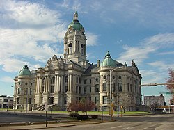
Government
The county government is a constitutional body, and is granted specific powers by the Constitution of Indiana, and by the Indiana Code.
County council: The county council is the fiscal branch of the county government that has the legislative responsibilities for the spending and revenue collection in the county. Four representatives are elected from county districts and three are elected at-large by the entire county. The council members serve four-year terms. They are responsible for setting salaries, the annual budget, and special spending. The council also has limited authority to impose local taxes, in the form of an income and property tax that is subject to state level approval, excise taxes, and service taxes. [6] [7]
Board of commissioners: The executive body of the county is made of a board of commissioners. The commissioners are elected county-wide but must live within the district of the seat they hold, in staggered terms, and each serves a four-year term. One of the commissioners, typically the most senior, serves as president. The commissioners are charged with executing the acts legislated by the council, collecting revenue, and managing the day-to-day functions of the county government. [6] [7]
Court: The county has eight state trial courts of original jurisdiction. One circuit court and seven superior courts. The judges offices are non-partisan with terms of six years. A judge must be a member of the Indiana Bar Association. The judges are assisted by magistrates that are appointed. circuit court. [7]
County officials: The county has several other elected offices, including sheriff, coroner, auditor, treasurer, recorder, surveyor, and circuit court clerk. Each of these elected officers serves a term of four years and oversees a different part of county government. Members elected to county government positions are required to declare party affiliations and to be residents of the county. [7]
Vanderburgh County is generally a Republican-leaning swing county in presidential elections. Only two Democratic candidates - George McGovern in 1972 and Hillary Clinton in 2016 - have failed to win 40 percent of the county's vote since 1928. The city of Evansville itself is a swing city; it voted for Donald Trump in 2016 by 4 points, and four years later for Joe Biden, also by 4 points. [9] In 2020, former Evansville mayor Jonathan Weinzapfel (a Democrat) carried the county in his bid for the office of Attorney General but lost statewide.
The county is located in the 8th congressional district, which was notoriously dubbed "The Bloody Eighth" because of its tendency to oust incumbents from both parties - since 1933, no Congressman has represented the district longer than 12 years in a row. [10]
Demographics
Historical population| Census | Pop. | Note | %± |
|---|
| 1820 | 1,798 | | — |
|---|
| 1830 | 2,611 | | 45.2% |
|---|
| 1840 | 6,250 | | 139.4% |
|---|
| 1850 | 11,414 | | 82.6% |
|---|
| 1860 | 20,552 | | 80.1% |
|---|
| 1870 | 33,145 | | 61.3% |
|---|
| 1880 | 42,193 | | 27.3% |
|---|
| 1890 | 59,809 | | 41.8% |
|---|
| 1900 | 71,769 | | 20.0% |
|---|
| 1910 | 77,438 | | 7.9% |
|---|
| 1920 | 92,293 | | 19.2% |
|---|
| 1930 | 113,320 | | 22.8% |
|---|
| 1940 | 130,783 | | 15.4% |
|---|
| 1950 | 160,422 | | 22.7% |
|---|
| 1960 | 165,794 | | 3.3% |
|---|
| 1970 | 168,772 | | 1.8% |
|---|
| 1980 | 167,515 | | −0.7% |
|---|
| 1990 | 165,058 | | −1.5% |
|---|
| 2000 | 171,922 | | 4.2% |
|---|
| 2010 | 179,703 | | 4.5% |
|---|
| 2020 | 180,136 | | 0.2% |
|---|
| 2023 (est.) | 179,810 | [11] | −0.2% |
|---|
|
2020 census
As of the 2020 census, the county had a population of 180,136. The median age was 38.6 years. 21.6% of residents were under the age of 18 and 17.9% of residents were 65 years of age or older. For every 100 females there were 94.3 males, and for every 100 females age 18 and over there were 91.5 males age 18 and over. [17] [18]
The racial makeup of the county was 80.6% White, 9.8% Black or African American, 0.2% American Indian and Alaska Native, 1.4% Asian, 0.4% Native Hawaiian and Pacific Islander, 1.6% from some other race, and 6.0% from two or more races. Hispanic or Latino residents of any race comprised 3.5% of the population. [18]
92.0% of residents lived in urban areas, while 8.0% lived in rural areas. [19]
There were 76,084 households in the county, of which 27.0% had children under the age of 18 living in them. Of all households, 41.0% were married-couple households, 21.1% were households with a male householder and no spouse or partner present, and 30.0% were households with a female householder and no spouse or partner present. About 33.6% of all households were made up of individuals and 12.7% had someone living alone who was 65 years of age or older. [17]
There were 84,058 housing units, of which 9.5% were vacant. Among occupied housing units, 63.5% were owner-occupied and 36.5% were renter-occupied. The homeowner vacancy rate was 1.8% and the rental vacancy rate was 11.6%. [17]
2010 census
As of the 2010 United States census, there were 179,703 people, 74,454 households, and 45,118 families residing in the county. [20] The population density was 769.7 inhabitants per square mile (297.2/km2). There were 83,003 housing units at an average density of 355.5 per square mile (137.3/km2). [4] The racial makeup of the county was 86.2% white, 9.1% black or African American, 1.1% Asian, 0.2% American Indian, 0.1% Pacific islander, 1.0% from other races, and 2.3% from two or more races. Those of Hispanic or Latino origin made up 2.2% of the population. [20] In terms of ancestry, 32.3% were German, 18.3% were American, 11.7% were Irish, and 9.4% were English. [21]
Of the 74,454 households, 28.9% had children under the age of 18 living with them, 42.9% were married couples living together, 13.1% had a female householder with no husband present, 39.4% were non-families, and 32.3% of all households were made up of individuals. The average household size was 2.31 and the average family size was 2.93. The median age was 37.5 years. [20]
The median income for a household in the county was $47,697 and the median income for a family was $57,076. Males had a median income of $42,663 versus $31,037 for females. The per capita income for the county was $23,945. About 10.7% of families and 15.6% of the population were below the poverty line, including 22.4% of those under age 18 and 7.7% of those age 65 or over. [22]
This page is based on this
Wikipedia article Text is available under the
CC BY-SA 4.0 license; additional terms may apply.
Images, videos and audio are available under their respective licenses.