Chandler, Indiana

Last updated

Chandler, Indiana
Town of Chandler
Chandler Community Center.jpg
Chandler Community Center
Warrick County Indiana Incorporated and Unincorporated areas Chandler Highlighted 1812034.svg
Location of Chandler in Warrick County, Indiana.
Coordinates: 38°2′14″N87°22′27″W / 38.03722°N 87.37417°W / 38.03722; -87.37417
Country United States
State Indiana
County Warrick
Townships Boon, Ohio
Area
[1]
  Total2.91 sq mi (7.55 km2)
  Land2.91 sq mi (7.55 km2)
  Water0.00 sq mi (0.00 km2)
Elevation
[2]
387 ft (118 m)
Population
 (2020)
  Total3,693
  Density1,267.33/sq mi (489.29/km2)
Time zone UTC-6 (CST)
  Summer (DST) UTC-5 (CDT)
ZIP code
47610
Area code 812
FIPS code 18-12034 [3]
GNIS feature ID2396639 [2]
Website http://www.townofchandler.org/

Chandler is a town straddling Ohio and Boon Township in Warrick County, Indiana, United States, located just east of Evansville, Indiana along the Ohio River. [2] The population was 3,693 at the 2020 census, making it Warrick County's second-most populous municipality after Boonville. The town is part of the Evansville metropolitan area with a population of 342,815.

Contents

History

In 1847, the area which is now Chandler opened a post office named Lee to serve its residents. [4] By that time, a portion of the Central Canal (a piece of the Wabash and Erie Canal) was completed just outside of town that connected nearby Evansville with present-day Worthington. The canal system was never fully completed, having met its doom with financial problems and competition from the railroad boom, but part of the canal remains today along with the old tow path, aptly named Tow Path Road. [5]

In 1874, Lee officially became Chandler. The town got its new moniker from O.E. Chandler, the foreman of the Lake Erie, Evansville & South Western Railroad, which had completed construction on a new railway through town the year before. Using the creek bed from the failed Wabash and Erie Canal, L E E & S W RR created a rail line from Evansville through Chandler and on to Gentryville. Although the line is no longer used for passenger travel, Norfolk Southern still operates cargo trains on a portion of the railway that follows the Central Canal. The former Chandler Depot also remains, although it now serves as a private residence. [5]

In 1875, the first underground coal mine in town opened, Chandler Mine. Warrick County lies on the eastern edge of the Illinois Basin, making it a vast coal resource; once the use of coal became mainstreamed for locomotives (and later, for generating electricity), companies flocked to the area to begin mining operations. Chandler was no different, with six different underground mines having operated here at various times over nearly a century. No more than three underground mines operated at any one time in Chandler; the Erie Canal/Air Line Mine had the longest history, having operated for 40 years before shutting down in 1937.

By the mid-1940s, all but one mine had shut down. This allowed for above-ground development, and the construction business boomed. Within a five-year period, houses sprung up like mushrooms and the population more than doubled.

In 1953, the town became incorporated, and three trustees and a clerk-treasurer were elected to lead the citizens of Chandler. For the next two decades, town officials and residents worked to organize and equip a volunteer fire department, improve streets and install street lights, construct water wells and a water treatment plant, complete a sewer treatment plant and system, and purchase a building to house town offices. More recently, residential, commercial, and industrial development has remained slow and steady.

Geography

According to the 2010 census, Chandler has a total area of 2.03 square miles (5.26 km2), all land. [6]

Climate

The climate in this area is characterized by hot, humid summers and generally cool to cold winters. According to the Köppen Climate Classification system, Chandler has a humid subtropical climate, abbreviated "Cfa" on climate maps. [7]

Demographics

Historical population
CensusPop.Note
1960 1,784
1970 2,03213.9%
1980 3,04349.8%
1990 3,0991.8%
2000 3,094−0.2%
2010 2,887−6.7%
2020 3,69327.9%
U.S. Decennial Census [8]

2010 census

As of the census [9] of 2010, there were 2,887 people, 1,101 households, and 791 families residing in the town. The population density was 1,422.2 inhabitants per square mile (549.1/km2). There were 1,285 housing units at an average density of 633.0 per square mile (244.4/km2). The racial makeup of the town was 97.9% White, 0.3% African American, 0.1% Native American, 0.1% Asian, 0.4% from other races, and 1.1% from two or more races. Hispanic or Latino of any race were 1.3% of the population.

There were 1,101 households, of which 37.1% had children under the age of 18 living with them, 52.4% were married couples living together, 14.4% had a female householder with no husband present, 5.0% had a male householder with no wife present, and 28.2% were non-families. 22.6% of all households were made up of individuals, and 9.1% had someone living alone who was 65 years of age or older. The average household size was 2.62 and the average family size was 3.06.

The median age in the town was 36 years. 27.2% of residents were under the age of 18; 7.8% were between the ages of 18 and 24; 27.2% were from 25 to 44; 26.2% were from 45 to 64; and 11.6% were 65 years of age or older. The gender makeup of the town was 48.8% male and 51.2% female.

2000 census

As of the census [3] of 2000, there were 3,094 people, 1,178 households, and 882 families residing in the town. The population density was 1,831.9 inhabitants per square mile (707.3/km2). There were 1,267 housing units at an average density of 750.2 per square mile (289.7/km2). The racial makeup of the town was 98.61% White, 0.36% African American, 0.13% Native American, 0.06% Asian, 0.06% Pacific Islander, 0.06% from other races, and 0.71% from two or more races. Hispanic or Latino of any race were 0.58% of the population.

There were 1,178 households, out of which 36.8% had children under the age of 18 living with them, 57.5% were married couples living together, 13.5% had a female householder with no husband present, and 25.1% were non-families. 21.0% of all households were made up of individuals, and 8.2% had someone living alone who was 65 years of age or older. The average household size was 2.63 and the average family size was 3.04.

In the town, the population was spread out, with 27.5% under the age of 18, 8.5% from 18 to 24, 32.2% from 25 to 44, 22.1% from 45 to 64, and 9.7% who were 65 years of age or older. The median age was 34 years. For every 100 females, there were 98.1 males. For every 100 females age 18 and over, there were 93.8 males.

The median income for a household in the town was $36,047, and the median income for a family was $39,500. Males had a median income of $29,074 versus $21,142 for females. The per capita income for the town was $16,172. About 10.1% of families and 14.1% of the population were below the poverty line, including 25.3% of those under age 18 and 7.7% of those age 65 or over.
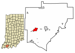
Law and government

Chandler uses the town council form of government, led by a five-member town council and a clerk-treasurer. The town council holds both legislative and executive powers while the clerk-treasurer is responsible for financial matters. Following staggered terms commencing in 2015, all are elected for four-year terms.

DistrictCouncil MemberFirst ElectedTerm EndsPolitical PartyOther titles
1Cheryl Amos20192023 Democratic Party
2Kim Burnett20182022 Republican Party
3Tonya Wester20192023 Republican Party President
4Ron Whitledge20152022 Republican Party Vice-President
At-LargeSandy Elder20192023 Democratic Party

Some of the governmental functions are handled through Warrick County officials. The county maintains a small claims court that can handle some civil cases. The judge on the court is elected to a term of four years and must be a member of the Indiana Bar Association. The judge is assisted by a constable who is also elected to a four-year term. In some cases, court decisions can be appealed to the state level circuit court. [10]

Chandler is represented by Vaneta Becker (District 50) in the Indiana State Senate. The town is located in the 8th District of Indiana (map) and served by U.S. Representative Larry Bucshon, a resident of Newburgh.

Education

Chandler has a public library, a branch of the Ohio Township Public Library System. [11]

Transportation

Warrick Area Transit System (WATS) provides bus service linking Chandler to the Metropolitan Evansville Transit System and the Evansville metro. [12]

Related Research Articles

<span class="mw-page-title-main">Warrick County, Indiana</span> County in Indiana, United States

Warrick County is a county located in the U.S. state of Indiana. As of 2020, the population was 63,898. The county seat is Boonville. It was organized in 1813 and was named for Captain Jacob Warrick, an Indiana militia company commander killed in the Battle of Tippecanoe in 1811. It is one of the ten fastest-growing counties in Indiana.

<span class="mw-page-title-main">Delphi, Indiana</span> City in Indiana, United States

Delphi is a city in and the county seat of Carroll County, in the U.S. state of Indiana. Located twenty minutes northeast of Lafayette, it is part of the Lafayette, Indiana Metropolitan Statistical Area. The population was 2,893 at the 2010 census.

<span class="mw-page-title-main">Moores Hill, Indiana</span> Town in Indiana, United States

Moores Hill is a town in Sparta Township, Dearborn County, Indiana, United States. The population was 597 at the 2010 census.

<span class="mw-page-title-main">Brookville, Indiana</span> Town in Indiana, United States

Brookville is a town in Brookville Township, Franklin County, Indiana, United States. The town is the county seat of and the largest community entirely within Franklin County. The population was 2,596 at the 2010 census.

<span class="mw-page-title-main">Francisco, Indiana</span> Town in Indiana, United States

Francisco is the fifth largest town and seventh largest community in Gibson County, Indiana, United States. A town in Center Township, the population was 469 at the 2010 census and was founded in 1851. Local tradition says the town was named for its first settler, a Spanish laborer working on the Wabash and Erie Canal who built a shack in the area. It is part of the Evansville, Indiana, Metropolitan Area.

<span class="mw-page-title-main">Princeton, Indiana</span> City in Indiana, United States

Princeton is the largest city in and the county seat of Patoka Township, Gibson County, Indiana, United States. The population was 8,301 at the 2020 United States Census, and it is part of the greater Evansville, Indiana, Metropolitan Area.

<span class="mw-page-title-main">Roanoke, Indiana</span> Town in Indiana, United States

Roanoke is a town in Jackson Township, Huntington County, Indiana, United States. The population was 1,762 at the 2020 census. Roanoke is governed by a town council. Town offices include the clerk treasurer, utilities department, police department, and volunteer fire department. The town has a public elementary school. WOWO and WRNP have transmitter towers in Roanoke, along U.S. Highway 24. For many years, television station WPTA was licensed to Roanoke, though that station's studios and transmitter have always been located in nearby Fort Wayne.

<span class="mw-page-title-main">Shoals, Indiana</span> Town in Indiana, United States

Shoals is a town in Center and Halbert townships and the county seat of Martin County, in the U.S. state of Indiana. The population was 677 at the 2020 census, down from 756 in 2010.

<span class="mw-page-title-main">Cannelton, Indiana</span> City in Indiana, United States

Cannelton is a city in Troy Township, Perry County, in the U.S. state of Indiana, along the Ohio River. The population was 1,563 at the 2010 census. Cannelton, which was the smallest incorporated city in the state until 2010, was formerly the county seat of Perry County until the seat was relocated to Tell City.

<span class="mw-page-title-main">Farmersburg, Indiana</span> Town in Indiana, United States

Farmersburg is a town in Curry Township, Sullivan County, Indiana, United States. The population was 1,118 at the 2010 census. It is part of the Terre Haute Metropolitan Statistical Area. The town is adjacent to the Vigo County line and is overshadowed by several large TV and radio transmitter towers.

<span class="mw-page-title-main">Darmstadt, Indiana</span> Town in Indiana, United States

Darmstadt is a small, German-heritage town primarily located in Scott Township, Vanderburgh County, Indiana, United States. It also extends slightly into Armstrong, Center and German townships. The population was 1,407 at the 2010 census. Darmstadt, located just north of Evansville, is the only other incorporated municipality in Vanderburgh County besides Evansville.

<span class="mw-page-title-main">Perrysville, Indiana</span> Town in Indiana, United States

Perrysville is a town in Highland Township, Vermillion County, in the U.S. state of Indiana. The population was 456 at the 2010 census.

<span class="mw-page-title-main">Riley, Indiana</span> Town in Indiana, United States

Riley, once known as Lockport, is a town in Riley Township, Vigo County, in the U.S. state of Indiana. The population was 221 at the 2010 census. It is part of the Terre Haute Metropolitan Statistical Area.

<span class="mw-page-title-main">Boonville, Indiana</span> City in Indiana, United States

Boonville is a city in Boon Township, Warrick County, Indiana, United States. The population was 6,246 at the 2010 census. The city is the county seat of Warrick County.

<span class="mw-page-title-main">Elberfeld, Indiana</span> Town in Indiana, United States

Elberfeld is a town in Greer Township, Warrick County, in the U.S. state of Indiana. The population was 625 as of the 2010 census.

<span class="mw-page-title-main">Lynnville, Indiana</span> Town in Indiana, United States

Lynnville is a town in Hart Township, Warrick County, in the U.S. state of Indiana. The population was 888 at the 2010 census.

<span class="mw-page-title-main">Newburgh, Indiana</span> Human settlement in USA, founded 1829

Newburgh is a borough in Ohio Township, Warrick County, Indiana, United States, along the Ohio River. The population was 3,325 at the 2010 census, although the town is part of the larger Evansville metropolitan area which recorded a population of 342,815, and Ohio Township, which Newburgh shares with nearby Chandler, has a population of 37,749 in the 2010 census with over 17,000 of those living in the town and areas adjacent to the town. It is the easternmost suburb of Evansville.

<span class="mw-page-title-main">Tennyson, Indiana</span> Town in Indiana, United States

Tennyson is a town in Skelton Township, Warrick County, in the U.S. state of Indiana. The population was 279 at the 2010 census.

<span class="mw-page-title-main">Columbia City, Indiana</span> City in Indiana, United States

Columbia City is a city in Columbia Township, Whitley County, in the U.S. state of Indiana. The population was 9,892 at the 2020 Census, up from 8,750 at the 2010 Census, estimated to be 10,064 in 2023. The city is the county seat of Whitley County, and is the largest community therein. It is part of the Fort Wayne MSA.

<span class="mw-page-title-main">Canal Winchester</span> City in Ohio, United States

Canal Winchester is a city in Fairfield and Franklin counties in the U.S. state of Ohio. The city is one of the suburbs that make up the Columbus metropolitan area. The population was 9,107 at the 2020 census.

References

  1. "2020 U.S. Gazetteer Files". United States Census Bureau. Retrieved March 16, 2022.
  2. 1 2 3 U.S. Geological Survey Geographic Names Information System: Chandler, Indiana
  3. 1 2 "U.S. Census website". United States Census Bureau . Retrieved January 31, 2008.
  4. "Warrick County". Jim Forte Postal History. Archived from the original on October 3, 2015. Retrieved October 3, 2015.
  5. 1 2 "History". Town of Chandler, IN. Archived from the original on September 6, 2015. Retrieved October 3, 2015.
  6. "G001 - Geographic Identifiers - 2010 Census Summary File 1". United States Census Bureau. Archived from the original on February 13, 2020. Retrieved July 13, 2015.
  7. Climate Summary for Chandler, Indiana
  8. "Census of Population and Housing". Census.gov. Retrieved June 4, 2015.
  9. "U.S. Census website". United States Census Bureau . Retrieved December 11, 2012.
  10. Indiana Code. "Title 2, Article 10, Section 2" (PDF). IN.gov. Retrieved September 16, 2008.
  11. "Homepage". Ohio Township Public Library System. Archived from the original on March 16, 2018. Retrieved March 15, 2018.
  12. "WATS" . Retrieved September 6, 2023.