Indiana Register of Historic Sites and Structures

Last updated
Location of the state of Indiana in the United States, highlighted in red. Indiana in United States.svg
Location of the state of Indiana in the United States, highlighted in red.
Map all coordinates using: OpenStreetMap

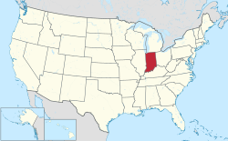
The Indiana Register of Historic Sites and Structures was created in 1981 by the Indiana General Assembly. The Survey and Registration Section of the Indiana Division of Historic Preservation and Archaeology oversees this state register. All places within Indiana that are listed on the National Register of Historic Places are automatically on Indiana's Register. Additional sites are on the state register, as the state's register does not require as many documents and sources for inclusion. [1]

Contents

State register

The following is a list of historic sites on the Indiana register, but not the national register. [2] For a list of historic sites on both the national register and the state register, see National Register of Historic Places listings in Indiana.

NameImageLocationCountyDescription
Bash Building Fort Wayne
41°04′53″N85°08′29″W / 41.0813°N 85.1413°W / 41.0813; -85.1413 (Bash Building)
Allen
Montgomery and Edith Beaver House Fort Wayne
41°03′37″N85°08′48″W / 41.0604°N 85.1467°W / 41.0604; -85.1467 (Montomergy and Edith Beaver House)
Allen
Fox Island Nature Preserve Archaeological District Fort Wayne
41°01′09″N85°14′13″W / 41.0193°N 85.2370°W / 41.0193; -85.2370 (Fox Island Nature Preserve Archaeological District)
Allen
William and Louise Thiel House Fort Wayne
41°04′43″N85°09′41″W / 41.0787°N 85.1615°W / 41.0787; -85.1615 (William & Louise Thiel House)
Allen
Lambert-Noblitt House Columbus
39°13′03″N85°55′20″W / 39.2174°N 85.9221°W / 39.2174; -85.9221 (Lambert-Noblitt House)
Bartholomew
Issac and Lula Breeding Farm Edinburgh
39°19′05″N85°57′17″W / 39.318°N 85.9546°W / 39.318; -85.9546 (Issac and Lula Breeding Farm)
Bartholomew
George and Elizabeth Newlin House Columbus
39°13′44″N85°55′13″W / 39.2288°N 85.9204°W / 39.2288; -85.9204 (George and Elizabeth Newlin House)
Bartholomew
Howard School Howard School near Brownsburg.jpg Perry Township
39°55′51″N86°22′57″W / 39.9309°N 86.3825°W / 39.9309; -86.3825 (Howard School)
Boone
Jacob Jones House Lebanon
40°02′58″N86°28′07″W / 40.0495°N 86.4687°W / 40.0495; -86.4687 (Jacob Jones House)
Boone
Jackson Township School Gymnasium Camden
40°36′36″N86°32′16″W / 40.6100°N 86.5378°W / 40.6100; -86.5378 (Jackson Township School Gymnasium)
Carroll
Carroll County Bridge #85 Paint Creek Bridge at Delphi.jpg Delphi
40°35′42″N86°40′43″W / 40.5951°N 86.6787°W / 40.5951; -86.6787 (Carroll County Bridge #85)
Carroll Also known as the Paint Creek Bridge.
Reed Case House Reed Case House 4-21-14 035.jpg Delphi
40°35′30″N86°40′50″W / 40.5917°N 86.6805°W / 40.5917; -86.6805 (Reed Case House)
Carroll
Law Offices and Pharos Newspaper Building Logansport
40°45′16″N86°21′57″W / 40.7545°N 86.3659°W / 40.7545; -86.3659 (Law Offices and Pharos Newspaper Building)
Cass
People's Bank Building Logansport
40°45′08″N86°22′00″W / 40.7521°N 86.3667°W / 40.7521; -86.3667 (People's Bank Building)
Cass
Walton-Tipton Township Public Library Walton Library.jpg Walton
40°39′40″N86°14′34″W / 40.6611°N 86.2427°W / 40.6611; -86.2427 (Walton-Tipton Township Public Library)
Cass
Montrose (John McCulloch House) Clarksville
38°18′18″N85°46′36″W / 38.3051°N 85.7767°W / 38.3051; -85.7767 (Montrose (John McCulloch House))
Clark
Schwartz-Voigt Farm Jeffersonville
38°20′23″N85°41′26″W / 38.3398°N 85.6906°W / 38.3398; -85.6906 (Schwartz-Voigt Farm)
Clark
Avery House Frankfort
40°16′51″N86°31′00″W / 40.2808°N 86.5166°W / 40.2808; -86.5166 (Avery House)
Clinton
Mary Ann Cole Archaeological Site Leavenworth
38°10′58″N86°19′41″W / 38.1827°N 86.3280°W / 38.1827; -86.3280 (Mary Ann Cole Archaeological Site)
Crawford
Wolber-Stryker Stone Wall Lawrenceburg
39°07′38″N84°54′36″W / 39.1272°N 84.9099°W / 39.1272; -84.9099 (Wolber-Stryker Stone Wall)
Dearborn
Second Dearborn County Courthouse and Offices Wilmington
39°03′45″N84°56′43″W / 39.0624°N 84.9454°W / 39.0624; -84.9454 (Second Dearborn County Courthouse and Offices)
Dearborn
Charles Zoller House Greensburg
39°20′11″N85°28′47″W / 39.3363°N 85.4797°W / 39.3363; -85.4797 (Charles Zoller House)
Decatur
Altona Baptist Church Altona
41°21′04″N85°09′23″W / 41.3511°N 85.1563°W / 41.3511; -85.1563 (Altona Baptist Church)
DeKalb
Samuel DePew House Richland Township
41°22′50″N85°10′16″W / 41.3806°N 85.1712°W / 41.3806; -85.1712 (Samuel DePew House)
DeKalb
Keyser Township District School 5 Church at Garrett.jpg Garrett
41°19′48″N85°08′07″W / 41.3301°N 85.1352°W / 41.3301; -85.1352 (Keyser Township District School 5)
DeKalb
Robert Lindsey Bartlett House Salem Township
40°05′45″N85°34′18″W / 40.0958°N 85.5717°W / 40.0958; -85.5717 (Robert Lindsey Bartlett House)
Delaware
High Street United Methodist Church Muncie
40°11′32″N85°23′18″W / 40.1922°N 85.3882°W / 40.1922; -85.3882 (High Street United Methodist Church)
Delaware
McCain Archaeological Site Dubois
Johann Bernard Woebkenberg Farm Dubois
Dale-Zook House Elkhart
Elkhart River Race Industrial District Elkhart
Phelps House/Knickerbocker Weddings Elkhart
P. H. and F. M. Roots Company Factory Fayette
J.D. Fine Boggs House Fountain
Alley Ford Bridge #48 Franklin
Grass Creek Railroad Depot Fulton
Jasper Newton Davidson House Gibson
Moore Rockshelter Archaeological Site Gibson
Moss Opera House Greene
Arcadia Depot Hamilton
Carmel Monon R.R. Depot Hamilton
Forest Park Log Cabin Hamilton
Old Carmel Library Hamilton
S. Waltz Farm Hamilton
Leora Brown School Leora brown school1.jpg Corydon Harrison
Squire Boone Gristmill Squire Boone Caverns mill 3.jpg Mauckport
38°3′51″N86°8′4″W / 38.06417°N 86.13444°W / 38.06417; -86.13444 (Squire Boone Gristmill)
Harrison Grist mill of Daniel Boone's brother Squire Boone
Walker School (Lincoln Township District School #1) Brownsburg Hendricks
North Salem Commercial Historic District Hendricks
Wabash & Erie Canal Wabash and Erie Canal (Delphi).png Huntington
William Ferris House Jay
Redkey City Building Jay
Butler Elementary School Jennings
Jennings County Carnegie Library Jennings
Grafton-Peek Building Johnson
William Barringer Brown House Lake
Wicker Memorial Park Lake
Martin and Susan Wood House Lake
Charles Danitschek Log Cabin LaPorte
Haskell and Barker Car and Manufacturing Company LaPorte
Logan-Taylor House LaPorte
Long Beach Town Center Building LaPorte
Milwaukee Railroad Depot Bedford Lawrence
William Stickles Hotel Bedford Lawrence
Big Four Railroad Station Madison
Interurban Depot Number 10 Madison
Mendon Episcopal Church Madison
Brookside Building Indianapolis
39°46′54″N86°07′22″W / 39.7816°N 86.1227°W / 39.7816; -86.1227 (Brookside Building)
Marion
Charity Dye School No. 27 Indianapolis
39°47′25″N86°08′51″W / 39.7904°N 86.1474°W / 39.7904; -86.1474 (Charity Dye School No. 27)
Marion
Charles W. Fairbanks House Indianapolis
39°48′35″N86°09′26″W / 39.8097°N 86.1573°W / 39.8097; -86.1573 (Charles W. Fairbanks House)
Marion
Chicago, Indianapolis, & Louisville Railroad Bridge #B178.9 Monon Trail bridge in Indianapolis.jpg Indianapolis
39°49′13″N86°08′12″W / 39.8203°N 86.1366°W / 39.8203; -86.1366 (Chicago, Indianapolis, & Louisville Railroad Bridge #B178.9)
Marion
Daubenspeck Farm Indianapolis
39°55′02″N86°11′07″W / 39.9173°N 86.1852°W / 39.9173; -86.1852 (Daubenspeck Farm)
Marion
Edwards-Aufderheide House Indianapolis
39°52′58″N86°09′15″W / 39.8828°N 86.1542°W / 39.8828; -86.1542 (Edwards-Aufderheide)
Marion
First German Reformed Church & School Indianapolis
39°46′53″N86°06′43″W / 39.7815°N 86.1120°W / 39.7815; -86.1120 (First German Reformed Church & School)
Marion
Fisher House (Indianapolis) Indianapolis
39°51′47″N86°10′45″W / 39.8630°N 86.1791°W / 39.8630; -86.1791 (Fisher House)
Marion
Florence Fay School No. 21 Indianapolis
39°45′34″N86°06′57″W / 39.7594°N 86.1158°W / 39.7594; -86.1158 (Florence Fay School No. 21)
Marion
Fowler-Mundy Pioneer Cemetery Indianapolis
39°39′37″N86°12′21″W / 39.6603°N 86.2058°W / 39.6603; -86.2058 (Fowler-Mundy Pioneer Cemetery)
Marion
General Motors Buick Showroom Building Indianapolis
39°47′04″N86°09′28″W / 39.7844°N 86.1579°W / 39.7844; -86.1579 (General Motors Buick Showroom Building)
Marion
Holy Cross–Westminster Historic District Indianapolis
39°46′16″N86°08′01″W / 39.7712°N 86.1335°W / 39.7712; -86.1335 (Holy Cross–Westminster Historic District)
Marion
Hotel Barton Michigan St. - Indianapolis.jpg Indianapolis
39°46′27″N86°09′14″W / 39.7743°N 86.1538°W / 39.7743; -86.1538 (Hotel Barton)
Marion
Indiana Dental College Building Indianapolis
39°46′11″N86°09′17″W / 39.7696°N 86.1547°W / 39.7696; -86.1547 (Indiana Dental College Building)
Marion
Indianapolis Automobile Industry Thematic District Indianapolis, Speedway
(various locations)
Marion
Julius Gally Wines & Cigars Indianapolis
39°46′49″N86°09′02″W / 39.7802°N 86.1505°W / 39.7802; -86.1505 (Julius Gally Wines & Cigars)
Marion
Kassebaum Building Kassebaum Building - 2010.jpg Indianapolis
39°52′13″N86°08′33″W / 39.8704°N 86.1426°W / 39.8704; -86.1426 (Kassebaum Building)
Marion
Lawrence High School (Indiana) Lawrence
39°50′24″N86°01′19″W / 39.8401°N 86.0219°W / 39.8401; -86.0219 (Lawrence High School)
Marion
Minnie Hartmann School No. 78 Indianapolis
39°46′24″N86°06′11″W / 39.7732°N 86.1030°W / 39.7732; -86.1030 (Minnie Hartmann School No. 78)
Marion
Oliver P. Morton School No. 29 Indianapolis
39°47′47″N86°08′40″W / 39.7963°N 86.1444°W / 39.7963; -86.1444 (Oliver P. Morton School No. 29)
Marion
Paul C. Stetson School No. 76 Indianapolis
39°48′35″N86°08′40″W / 39.8096°N 86.1444°W / 39.8096; -86.1444 (Paul C. Stetson School No. 76)
Marion
Reuben Wells Reuben Wells 1.jpg Indianapolis
The Children's Museum of Indianapolis
39°48′39″N86°9′27″W / 39.81083°N 86.15750°W / 39.81083; -86.15750 (Reuben Wells Locomotive)
Marion
Spring Valley Cemetery Lawrence
39°51′30″N86°00′39″W / 39.8584°N 86.0108°W / 39.8584; -86.0108 (Spring Valley Cemetery)
Marion
West Park Christian Church Indianapolis
39°45′58″N86°12′16″W / 39.7662°N 86.2044°W / 39.7662; -86.2044 (West Park Christian Church)
Marion
Culver Railroad Station Marshall
District #3 Schoolhouse Marshall
Immanuel Lutheran Church Marshall
Lewis Brooks Home Martin
Paw Paw Church & Cemetery Miami
Saint Charles Borromeo Catholic Church Miami
Borland House & Furst Quarry Monroe
John Campbell House Monroe
North Indiana Avenue Historic District Monroe
Montgomery County Bridge #49 Montgomery
Jones Schoolhouse Morgan
Newton County Bridge #57 Conrad Bridge P5160086.jpg The Conrad Bridge
41°06′11.2″N87°26′58.3″W / 41.103111°N 87.449528°W / 41.103111; -87.449528
Newton
Wilmot Milling Company Noble
David Brown House David Brown House 004.jpg Ohio
Jeffrey and Janet Pickett Log House Ohio
James Alverson House Owen
J.J. Daniels House Parke J.J. Daniels House and former Rockville Motel
Governor Joseph Albert Wright House Parke
Clarence H. Martin House Porter
Bone Bank Archaeological Site Posey
Hovey Lake-Klein Archeological Site 37°49′49″N87°57′13″W / 37.83028°N 87.95361°W / 37.83028; -87.95361 (Hovey Lake-Klein Archeological Site) Posey Archaeological site of the Mississippian culture
Medaryville Calaboose Pulaski
Highnote House Putnam
Julian Family Home Putnam
John Eckert & Sons Hardware Store Ripley
Hackleman Log Cabin Rush
Downtown South Bend Multiple Resources Area South Bend St. Joseph
Union Station (South Bend) South Bend St. Joseph
Daniel Ward House St. Joseph
Vevay Historic District Switzerland
Agriculture Hall Tippecanoe
Joseph Hawkins House Tippecanoe
Hawkins-Bower House Tippecanoe
Levi & Lucy Morehouse Farm Tippecanoe
John Purdue Block Tippecanoe
Downtown Evansville Multiple Resource Area Vanderburgh
Old Fellows Temple Terre Haute Vigo
Alfred Pegg House Vigo
U.S. Trust Company Building Vigo
Hopewell Church Wabash
Presbyterian Church of Williamsport Williamsport Warren
Livonia Presbyterian Church Livonia Washington
Salem Presbyterian Church Salem Washington
Charles Deam House & Arboretum Wells
Leaman-Stewart Farm Whitley
Jonas Nolt Homestead Whitley
Swihart House Whitley

See also

Related Research Articles

<span class="mw-page-title-main">Marshall Covered Bridge</span> Bridge in Liberty, Indiana

The Marshall Covered Bridge is a single span Burr arch truss covered bridge structure that was built by Joseph A. Britton & Son in 1917. The bridge is 74 ft (23 m) long, 15 ft (4.6 m) wide, and 14 ft (4.3 m) high.

<span class="mw-page-title-main">Mecca Covered Bridge</span> Place in Indiana listed on National Register of Historic Places

The Mecca Covered Bridge crossing Big Raccoon Creek East of Mecca, Indiana is a single span Burr Arch Truss covered bridge structure that was built by J. J. Daniels in 1873. The bridge is 176 feet (54 m) long, 17 feet (5.2 m) wide, and 12.5 feet (3.8 m) high.

<span class="mw-page-title-main">Washington Avenue Historic District (Evansville, Indiana)</span> Historic district in Indiana, United States

Washington Avenue Historic District is a national historic district located at Evansville, Indiana. It was listed on the National Register of Historic Places in 1980. The district, bounded roughly by Madison and Grand Avenues and East Gum and Parrett Streets, sprang up in the late 19th century, during an economic boom when the city's population went from 29,200 in 1880 to more than 59,000 by 1900.

<span class="mw-page-title-main">Forest Hills Historic District (Indianapolis, Indiana)</span> Historic district in Indiana, United States

Forest Hills Historic District is a national historic district located at Indianapolis, Indiana. It encompasses 173 contributing buildings and 7 contributing structures in a planned residential section of Indianapolis. It developed between about 1911 and 1935, and includes representative examples of Tudor Revival and English Cottage style architecture.

<span class="mw-page-title-main">National Register of Historic Places listings in Clark County, Indiana</span>

This is a list of the National Register of Historic Places listings in Clark County, Indiana.

<span class="mw-page-title-main">National Register of Historic Places listings in Hancock County, Indiana</span>

This is a list of the National Register of Historic Places listings in Hancock County, Indiana.

<span class="mw-page-title-main">National Register of Historic Places listings in Jay County, Indiana</span>

This is a list of the National Register of Historic Places listings in Jay County, Indiana.

<span class="mw-page-title-main">National Register of Historic Places listings in Putnam County, Indiana</span>

This is a list of the National Register of Historic Places listings in Putnam County, Indiana.

<span class="mw-page-title-main">Star Milling and Electric Company Historic District</span> Historic district in Indiana, United States

Star Milling and Electric Company Historic District, also known as Star Mill Falls and Star Gristmill, is a historic industrial complex and national historic district located in Lima Township, LaGrange County, Indiana. The district encompasses one contributing building, one contributing site, and two contributing structures. They are a small hydroelectric powerhouse (1929), two dams (1929), and the site of the original 1870 grist mill / hydroelectric generating plant. The old mill generated electric power from 1911 to 1929, and in 1930 the new powerhouse began operation.

<span class="mw-page-title-main">North Washington Street Historic District (Bloomington, Indiana)</span> Historic district in Indiana, United States

North Washington Street Historic District is a national historic district located in the city of Bloomington of Monroe County, Indiana. The district encompasses 35 contributing buildings and 6 contributing structures in a predominantly residential section of Bloomington. It developed between roughly 1870 and 1929, and includes notable examples of Queen Anne, Classical Revival, and Bungalow/American Craftsman style architecture. Located in the district is the separately listed Morgan House. Other notable buildings include the Showers-Graham House, Showers-Myers House, Teter House, and Washington Terrace Apartments (1929).

<span class="mw-page-title-main">Prospect Hill Historic District (Bloomington, Indiana)</span> Historic district in Indiana, United States

Prospect Hill Historic District is a national historic district located at Bloomington, Monroe County, Indiana. The district encompasses 38 contributing buildings and 8 contributing structures in a predominantly residential section of Bloomington. It developed between about 1840 and 1936, and includes notable examples of Queen Anne, Colonial Revival, Tudor Revival, Mission Revival, and Bungalow/American Craftsman style architecture. Located in the district is the separately listed Blair-Dunning House.

<span class="mw-page-title-main">Maple Grove Road Rural Historic District</span> Historic district in Indiana, United States

Maple Grove Road Rural Historic District is a national historic district located in Bloomington Township and Richland Township, Monroe County, Indiana. The district encompasses 69 contributing buildings, 7 contributing sites, 8 contributing structures, and 30 contributing objects in a rural area near Bloomington. The district developed between about 1828 and 1950, and include notable examples of Gothic Revival and Greek Revival style architecture. The contributing elements are located on 12 farmsteads. Located in the district is the separately listed Daniel Stout House.

<span class="mw-page-title-main">Highland Park Neighborhood Historic District</span> Historic district in Indiana, United States

Highland Park Neighborhood Historic District is a national historic district located at Lafayette, Tippecanoe County, Indiana. The district encompasses 240 contributing buildings, 1 contributing site, and 1 contributing structure in a planned residential subdivision of Lafayette. It developed between about 1892 and 1945 and includes representative examples of Queen Anne, Tudor Revival, and Bungalow / American Craftsman style architecture. Notable contributing resources include the Blistain Axel Merritt House (1914), John Wagner Jr. House, John Ross House, and Bicycle Bridge (1924).

<span class="mw-page-title-main">Ninth Street Hill Neighborhood Historic District</span> Historic district in Indiana, United States

Ninth Street Hill Neighborhood Historic District is a national historic district located at Lafayette, Tippecanoe County, Indiana. The district encompasses 88 contributing buildings and 6 contributing structures in a predominantly residential section of Lafayette. It developed between about 1850 and 1946 and includes representative examples of Gothic Revival, Italianate, Queen Anne, Greek Revival, and Second Empire style architecture. Located in the district is the separately listed Judge Cyrus Ball House. Other notable contributing resources include the Samuel Moore House (1891), Moore-Porter-Boswell House (1895), Stanley Coulter House (1890), Edward Bohrer House (1909), Thomas Wood House, Job M. Nash House (1859), and Gordon Graham House.

<span class="mw-page-title-main">New Augusta Historic District</span> Historic district in Indiana, United States

New Augusta Historic District is a national historic district located at Indianapolis, Indiana. It encompasses 114 contributing buildings, 1 contributing structure, and 1 contributing object in a railroad oriented village in Indianapolis. The district developed between about 1852 and 1939, and includes representative examples of Italianate and Bungalow / American Craftsman style architecture. Notable contributing buildings include the Odd Fellows Building, Hopewell Evangelical Lutheran Church, Salem Lutheran Church (1880), and New Augusta Depot. It is located west of Augusta.

<span class="mw-page-title-main">Indianapolis Veterans Administration Hospital</span> United States historic place

Indianapolis Veterans Administration Hospital, also known as Larue D. Carter Memorial Hospital is a historic hospital complex and national historic district located at Indianapolis, Indiana. The district resources were developed between 1930 and 1951 by the Veterans Administration, and encompasses 15 contributing buildings, 2 contributing sites, 2 contributing structures and 5 contributing objects on the hospital campus. The main complex is connected by an enclosed corridor and consists of the main hospital building (1931), kitchen/mess hall/boiler house/attendants' quarters, general medical building (1939), and recreation building (1941). The buildings reflect the Colonial Revival and Classical Revival styles of architecture.

<span class="mw-page-title-main">Marott Hotel</span> United States historic place

Marott Hotel is a historic residential hotel building located at Indianapolis, Indiana. It was built in 1926, and consists of two 11-story, reinforced concrete structures faced in red brick with ornamental terra cotta and glazed tile trim in the Georgian Revival style. The two towers are connected by a one-story structure that contained the lobby, event halls, gym, and indoor pool.

<span class="mw-page-title-main">Test Building</span> United States historic place

Test Building, also known as the Circle Motor Inn, is a historic commercial building in Indianapolis, Indiana. It was built in 1925, and is a nine-story, reinforced concrete structure with 12-inch thick brick and clay tile curtain walls. It is faced with Indiana limestone and has a three-story brick penthouse and two-level basement. The mixed-use building housed the city's earliest large parking garages.

<span class="mw-page-title-main">McCormick Cabin Site</span> Historic site in Indianapolis, Indiana, U.S.

McCormick Cabin Site is a historic site located at Indianapolis, Indiana. It is the site of the cabin John Wesley McCormick (1754–1837) built in 1820. It was at the cabin that commissioners appointed by the Indiana legislature met in June 1820 to select the site for the permanent seat of state government at Indianapolis. The site is commemorated by a granite boulder in White River State Park with plaque erected in 1924.

<span class="mw-page-title-main">Oriental Lodge No. 500</span> United States historic place

Oriental Lodge No. 500, known today as Prince Hall Masonic Temple, is a historic building located in Indianapolis, Indiana, United States. It was designed by Rubush & Hunter and others and completed in 1916. It is a four-story, rectangular, steel frame and reinforced concrete structure with brick exterior walls. It has terra cotta decorative elements that are interpretations of Islamic architecture of the Middle East, North Africa, and Spain.

References

  1. Archaeology, Historic Preservation & (January 29, 2021). "Identifying Historic Register Properties". Historic Preservation & Archaeology.
  2. "Indiana Department of Natural Resources-National/State Register". Indiana Department of Natural Resources. Retrieved 2013-02-21.