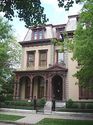
The Reitz Home Museum is a Victorian house museum located in the Riverside Historic District in downtown Evansville, Indiana. The museum offers year-round guided tours.

Fletcher Place is a historic district and neighborhood in the city of Indianapolis, Indiana named after Calvin Fletcher, a prominent local banker, farmer and state senator.

Chatham–Arch is a neighborhood located immediately east of Downtown Indianapolis, Indiana, United States. This neighborhood is one of the oldest in Indianapolis, dating back to the mid 19th century. Chatham–Arch contains many of Indianapolis's historic homes.

The Riverside Historic District is a U.S. historic district located in downtown Evansville, Indiana. It was added to the register in 1978 and roughly bounded by Southlane Drive, Walnut, Third, and Parrett Streets. It consists of 1,010 acres (4.1 km2) and 425 buildings. It is also known as the Riverside Neighborhood.

Old Northside is a residential neighborhood near downtown in Indianapolis, Indiana. It is bordered by 16th Street on the north, Pennsylvania Street on the west, Interstate I-65 on the south, and Bellefontaine Street on the east. The Monon Trail runs along the eastern edge of The Frank and Judy O'Bannon Old Northside Soccer Park.

The North Irvington Gardens Historic District is a neighborhood and national historic district in Indianapolis, Indiana. It was placed on the National Register of Historic Places on June 27, 2008. It is immediately to the north of the Irvington Historic District, which has been on the National Register since 1987, sharing the same east and west boundaries of the older district, and extending north to 10th and 11th streets. It is a neighborhood of mostly residential buildings dating primarily from 1910 to 1950, with no one distinctive architectural style, including a house associated with the historic Osborn Farm. Except for one church, the only buildings contributing to the historic nature of the district are 843 houses and 551 garages. Most fences in the district mark the perimeter of the individual properties; very few are along the streets.

Washington Avenue Historic District is a national historic district located at Evansville, Indiana. It was listed on the National Register of Historic Places in 1980. The district, bounded roughly by Madison and Grand Avenues and East Gum and Parrett Streets, sprang up in the late 19th century, during an economic boom when the city's population went from 29,200 in 1880 to more than 59,000 by 1900.

Oliver Johnson's Woods is a historic district and neighborhood on the northern side of Indianapolis, Indiana, United States. Located in southern Washington Township, the district occupies the site of what was once the family farm of Oliver Johnson. Born on the present site of the Indiana State Fairgrounds, Johnson grew up in a pioneer family that lived on the edge of the state capital city. Upon attaining adulthood, he bought property a short distance to the west, to which he moved in 1846. Here, he built a larger farmhouse in 1862, and he tilled the soil for most of the rest of his life. As Indianapolis grew northward, it reached the Johnson farm in the early twentieth century; the aged farmer and his sons saw the city's growth as an opportunity for financial gain, and in 1905 they announced the platting of 0.25 square miles (0.65 km2) of their property into individual lots. They chose an advantageous time to sell their property; as the new residents began to build their homes, an interurban railway was built along College Avenue on the district's western side that connected downtown with Broad Ripple. Many prosperous businessmen were attracted by the development's large lots and wooded streets; the city annexed Oliver Johnson's Woods in 1912, and by the outbreak of World War II, the streets were filled with large houses built in a wide variety of architectural styles. These early residents came from many different ethnicities: European immigrants were becoming more prosperous and leaving their ethnic enclaves, and new neighborhoods such as Oliver Johnson's Woods appealed to them. Among the neighborhood's leading residents was a colony of Jews of German descent.

The Cottage Home Historic District is a historic district and neighborhood located on the near east side of Indianapolis, Indiana. A small portion of Cottage Home is listed on the National Register of Historic Places while a larger area is listed on the state and local levels. Known for its preponderance of "cottage-style" homes built with strong Victorian influences, Cottage Home has historically been a working class neighborhood. Numerous industrial buildings are also scattered throughout the district, providing a base of economic activity. Today, however, many of these buildings are vacant, providing a special challenge to preservation and urban renewal efforts.
The Bayard Park Neighborhood is a neighborhood in Evansville, Indiana which is bounded by Lincoln Avenue, US Highway 41, Washington Avenue and Garvin Street. The Bayard Park Historic District contains approximately 87 acres including 335 contributing buildings and 1 contributing site within the neighborhood boundaries. It was added to the National Register of Historic Places in 1985. The architecture of residential homes in the neighborhood include quaint 1890s Queen Anne cottages, ground-hugging bungalows, American Fourquares, and high-style Early American and English revival types. The neighborhood also features Evansville's first neighborhood park and the East Branch Library, a Carnegie Library funded by the renowned philanthropist Andrew Carnegie.

Independence Historic District, also known as the West Franklin Street-Wabash Avenue Historic District, is a national historic district located in the Lamasco neighborhood of Evansville, Indiana. The district developed after 1880, and encompasses 95 contributing buildings and 1 contributing site. It includes commercial and residential properties and representative examples of Italianate, Queen Anne, Romanesque, and Beaux-Arts style architecture. Notable buildings include the West Branch Carnegie Library (1912), Laval Block, Heldt-Voelker Hardware Store (1890), First Federal Savings, Gerke Building, August Rosenberger House (1894), and St. Boniface Church.

Lincolnshire Historic District is a national historic district located at Evansville, Indiana. The district developed after 1923, and encompasses 95 contributing buildings in a predominantly residential section of Evansville. The district's homes have a mixture of Tudor Revival and Old and new World revival designs, including Colonial Revival. St. Benedict Cathedral and Bosse High School are two landmark buildings from the 1920s and 1930s.

Bankers Row Historic District is a national historic district located at Logansport, Cass County, Indiana. The district encompasses 20 contributing houses in a residential section of Logansport. It developed between about 1875 and 1925 and includes notable examples of Queen Anne and Italianate style architecture. Bankers Row gains significance because it is associated with the growth and development of Logansport. The town gained commercial success in 1840 with the Wabash & Erie Canal, and then in the 1850s, when the first railroad came through town. The name "Bankers Row" was given to these homes by locals in the 1960s because of its association in the earlier part of the century, with men in the field of finance and banking.

Forest Place Historic District is a national historic district located at Culver, Marshall County, Indiana. The district encompasses 14 contributing buildings in a residential section of Culver. It developed between about 1917 and 1922, and includes examples of Bungalow / American Craftsman style architecture. The houses are small 1+1⁄2-story frame dwellings, with either front gabled, side gabled, or hipped roofs.

Ellettsville Downtown Historic District is a national historic district located at Ellettsville, Monroe County, Indiana. The district encompasses 50 contributing buildings in the central business district and surrounding residential sections of Ellettsville. It developed between about 1840 and 1953, and includes notable examples of Queen Anne, Early Commercial, Gothic Revival, and Bungalow/American Craftsman style architecture. Notable buildings include the Robert Stimson House, May Presley House, Bradford House, George W. Fletcher House, Wickens House (1909), Capt. Gilbert Perry House, I.O.O.F. Building, Town Hall (1927), Masonic Building (1895), Knights of Pythias Building, First United Methodist Church (1900), and First Baptist Church (1909).

Ellsworth Historic District, also known as Ellsworth Addition, is a national historic district located at Lafayette, Tippecanoe County, Indiana. The district encompasses 144 contributing buildings, 1 contributing site, and 4 contributing structures in a predominantly residential section of Lafayette. It developed between about 1844 and 1936 and includes representative examples of Italianate, Second Empire, Queen Anne, and Bungalow / American Craftsman style architecture. Located in the district are the separately listed Falley Home, Moses Fowler House, and Temple Israel. Other notable buildings include the Second Presbyterian Church (1894-1895), Alexander House, Ball Brothers House, Falley Townhouse, Home Block, Annie Fowler House, and Duplex Townhouse.

Jefferson Historic District is a national historic district located at Lafayette, Tippecanoe County, Indiana. The district encompasses 161 contributing buildings, 2 contributing sites, and 22 contributing structures in a predominantly residential section of Lafayette. It developed between about 1853 and 1951 and includes representative examples of Italianate, Greek Revival, and Bungalow / American Craftsman style architecture. Notable contributing resources include the Deutsche Evangelische Kirche (1905), Isador Metzger House, Hubert Gilmartin House, B.F. Biggs Pump Factory Building, Deutsche Methodist Kirche (1885), Herman & Mary Fletemeyer House, Mohr House, Warrenberg-Reule Double House, Alfred Gaddis House, Wabash Valley House (1862), Haywood Tag Company Building (1928), and Jefferson High School (1927).
St. Joseph Neighborhood Historic District is a national historic district located at Indianapolis, Indiana. The district encompasses 57 contributing buildings in a predominantly residential section of Indianapolis. It was developed between about 1855 and 1930, and include representative examples of Italianate and Queen Anne style architecture. Located in the district are the separately listed Bals-Wocher House, William Buschmann Block, Delaware Court, Pearson Terrace, and The Spink. Other notable buildings include the Christian Place complex, Fishback-Vonnegut-New House, Henry Hilker House, Apollo-Aurora Rowhouses, Israel Traub Store, and Lorenzo Moody House.

Watson Park Historic District, also known as Watson Road Historic District and Watson McCord Neighborhood, is a national historic district located at Indianapolis, Indiana. The district encompasses 402 contributing buildings and 4 contributing sites in a predominantly residential section of Indianapolis. They include 255 houses, 27 multiple family dwellings, and 120 garages. It was developed between about 1910 and 1960, and includes representative examples of Colonial Revival, Tudor Revival, and Bungalow / American Craftsman style architecture. Located in the district is the Watson Park Bird Sanctuary.

Trinity United Methodist Church is a historic United Methodist church located in downtown Evansville, Indiana. The congregation began in 1825 as a Methodist class and its Gothic Revival style brick church building was completed in 1866. It was listed on the National Register of Historic Places in 1982.


