National Register of Historic Places listings in Noble County, Indiana

Last updated
Location of Noble County in Indiana Map of Indiana highlighting Noble County.svg
Location of Noble County in Indiana

This is a list of the National Register of Historic Places listings in Noble County, Indiana.

Contents

This is intended to be a complete list of the properties and districts on the National Register of Historic Places in Noble County, Indiana, United States. Latitude and longitude coordinates are provided for many National Register properties and districts; these locations may be seen together in a map. [1]

There are 16 properties and districts listed on the National Register in the county.

Properties and districts located in incorporated areas display the name of the municipality, while properties and districts in unincorporated areas display the name of their civil township. Properties and districts split between multiple jurisdictions display the names of all jurisdictions.

This National Park Service list is complete through NPS recent listings posted April 23, 2021. [2]
Map all coordinates using: OpenStreetMap  
Download coordinates as: KML

Current listings

[3] Name on the Register [4] ImageDate listed [5] Location City or townDescription
1 Ahavas Shalom Reform Temple
Ahavas Shalom Reform Temple Ahavas Shalom Reform Temple.jpg
Ahavas Shalom Reform Temple
June 16, 1983
(#83000143)
503 S. Main St.
41°27′42″N85°35′20″W / 41.461667°N 85.588889°W / 41.461667; -85.588889 (Ahavas Shalom Reform Temple)
Ligonier
2 Albion Courthouse Square Historic District
Albion Courthouse Square Historic District Noble County Indiana Courthouse.jpg
Albion Courthouse Square Historic District
December 31, 2013
(#13001014)
Roughly bounded by Highland, Oak, and Hazel Sts., and the alley east of Orange St.
41°23′48″N85°25′28″W / 41.396667°N 85.424444°W / 41.396667; -85.424444 (Albion Courthouse Square Historic District)
Albion
3 Brimfield School No. 2 March 11, 2019
(#100003504)
N 140 E, 1 blk. N. of E. 3rd St.
41°27′23″N85°23′52″W / 41.4563°N 85.3979°W / 41.4563; -85.3979 (Brimfield School No. 2)
Brimfield vicinity
4 Cromwell Historic District
Cromwell Historic District Jefferson north of Orange, Cromwell.jpg
Cromwell Historic District
September 14, 2015
(#15000597)
Jefferson between 2nd & Orange Sts.
41°24′04″N85°36′54″W / 41.401111°N 85.615000°W / 41.401111; -85.615000 (Cromwell Historic District)
Cromwell
5 Iddings-Gilbert-Leader-Anderson Block
Iddings-Gilbert-Leader-Anderson Block Iddings-Gilbert-Leader-Anderson Block.jpg
Iddings-Gilbert-Leader-Anderson Block
July 21, 1987
(#87000544)
105-113 N. Main St.
41°26′39″N85°15′58″W / 41.444167°N 85.266111°W / 41.444167; -85.266111 (Iddings-Gilbert-Leader-Anderson Block)
Kendallville
6 Jefferson Union Church and Sweet Cemetery
Jefferson Union Church and Sweet Cemetery Jefferson Union Church.jpg
Jefferson Union Church and Sweet Cemetery
March 24, 2010
(#10000126)
3015 E415N, east of Albion
41°24′44″N85°22′01″W / 41.412319°N 85.366919°W / 41.412319; -85.366919 (Jefferson Union Church and Sweet Cemetery)
Jefferson Township
7 Kendallville Downtown Historic District
Kendallville Downtown Historic District Kendallville-indiana-downtown.jpg
Kendallville Downtown Historic District
December 23, 2003
(#03001315)
Roughly bounded by Harris and Rush Sts. and the alleys east and west of Main
41°26′35″N85°15′55″W / 41.443056°N 85.265278°W / 41.443056; -85.265278 (Kendallville Downtown Historic District)
Kendallville
8 Kneipp Springs Historic District March 6, 2018
(#100002183)
2725 and 2730 E. Northport Rd.
41°30′17″N85°22′20″W / 41.504722°N 85.372222°W / 41.504722; -85.372222 (Kneipp Springs Historic District)
Orange Township
9 Ligonier Historic District
Ligonier Historic District Ligonier-indiana-downtown.jpg
Ligonier Historic District
October 23, 1987
(#87001798)
Roughly bounded by the former Conrail right-of-way and Smith, Union, College, and Grand Sts.
41°27′46″N85°35′23″W / 41.462778°N 85.589722°W / 41.462778; -85.589722 (Ligonier Historic District)
Ligonier
10 Luckey Hospital
Luckey Hospital Luckey Hospital in Wolf Lake.jpg
Luckey Hospital
March 20, 2013
(#13000090)
Junction of U.S. Route 33 and State Road 109 at Wolf Lake
41°20′00″N85°29′39″W / 41.333472°N 85.494167°W / 41.333472; -85.494167 (Luckey Hospital)
Noble Township
11 Noble County Courthouse
Noble County Courthouse Albion-indiana-courthouse.jpg
Noble County Courthouse
May 12, 1981
(#81000005)
Courthouse Square
41°23′45″N85°25′28″W / 41.395833°N 85.424444°W / 41.395833; -85.424444 (Noble County Courthouse)
Albion
12 Noble County Sheriff's House and Jail
Noble County Sheriff's House and Jail Noble County Sheriff's House and Jail.jpg
Noble County Sheriff's House and Jail
December 27, 1982
(#82000026)
W. Main and Oak Sts.
41°23′44″N85°25′34″W / 41.395556°N 85.426111°W / 41.395556; -85.426111 (Noble County Sheriff's House and Jail)
Albion
13 Stanley School-District No. 2
Stanley School-District No. 2 Stanley School at Chain O'Lakes.jpg
Stanley School-District No. 2
December 16, 2014
(#14001038)
S300E south of Albion
41°20′17″N85°21′57″W / 41.338056°N 85.365833°W / 41.338056; -85.365833 (Stanley School-District No. 2)
Green Township
14 Gene Stratton-Porter Cabin
Gene Stratton-Porter Cabin Cabin in Wildflower Woods.jpg
Gene Stratton-Porter Cabin
June 27, 1974
(#74000015)
Southeast of Rome City off State Road 9
41°28′51″N85°20′55″W / 41.480833°N 85.348611°W / 41.480833; -85.348611 (Gene Stratton-Porter Cabin)
Orange Township
15 Stone's Trace
Stone's Trace Tavern at Stone's Trace.jpg
Stone's Trace
May 24, 1984
(#84001212)
U.S. Route 33 and State Road 5, south of Ligonier
41°25′35″N85°35′10″W / 41.426389°N 85.586111°W / 41.426389; -85.586111 (Stone's Trace)
Sparta Township
16 Jacob Straus House
Jacob Straus House Jacob Straus House.jpg
Jacob Straus House
June 4, 1979
(#79000011)
210 S. Main St.
41°27′50″N85°35′22″W / 41.463889°N 85.589444°W / 41.463889; -85.589444 (Jacob Straus House)
Ligonier

See also

Related Research Articles

National Register of Historic Places listings in Allen County, Indiana

This is a list of the National Register of Historic Places listings in Allen County, Indiana.

National Register of Historic Places listings in Vigo County, Indiana

This is intended to be a complete list of the properties and districts on the National Register of Historic Places in Vigo County, Indiana, United States. Latitude and longitude coordinates are provided for many National Register properties and districts; these locations may be seen together in a map.

National Register of Historic Places listings in Rush County, Indiana

This is a list of the National Register of Historic Places listings in Rush County, Indiana.

National Register of Historic Places listings in Elkhart County, Indiana

This is a list of the National Register of Historic Places listings in Elkhart County, Indiana.

National Register of Historic Places listings in DeKalb County, Indiana

This is a list of the National Register of Historic Places listings in DeKalb County, Indiana.

National Register of Historic Places listings in Wabash County, Indiana

This is a list of the National Register of Historic Places listings in Wabash County, Indiana.

National Register of Historic Places listings in Benton County, Indiana

This is a list of the National Register of Historic Places listings in Benton County, Indiana.

National Register of Historic Places listings in Blackford County, Indiana

This is a list of the National Register of Historic Places listings in Blackford County, Indiana.

National Register of Historic Places listings in Washington County, Indiana

This is a list of the National Register of Historic Places listings in Washington County, Indiana.

National Register of Historic Places listings in Wells County, Indiana

This is a list of the National Register of Historic Places listings in Wells County, Indiana.

National Register of Historic Places listings in Whitley County, Indiana

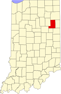
This is a list of the National Register of Historic Places listings in Whitley County, Indiana.

National Register of Historic Places listings in Jefferson County, Indiana

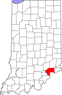
This is a list of the National Register of Historic Places listings in Jefferson County, Indiana.

National Register of Historic Places listings in Jennings County, Indiana

This is a list of the National Register of Historic Places listings in Jennings County, Indiana.

National Register of Historic Places listings in LaGrange County, Indiana

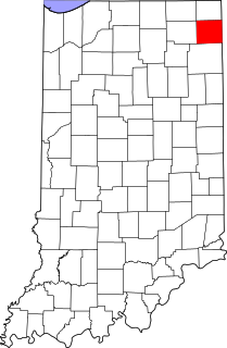
This is a list of the National Register of Historic Places listings in LaGrange County, Indiana.

National Register of Historic Places listings in LaPorte County, Indiana

This is a list of the National Register of Historic Places listings in LaPorte County, Indiana.

National Register of Historic Places listings in Orange County, Indiana

This is a list of the National Register of Historic Places listings in Orange County, Indiana.

National Register of Historic Places listings in Ripley County, Indiana

This is a list of the National Register of Historic Places listings in Ripley County, Indiana.

National Register of Historic Places listings in Steuben County, Indiana

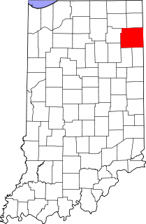
This is a list of the National Register of Historic Places listings in Steuben County, Indiana.

National Register of Historic Places listings in Tipton County, Indiana

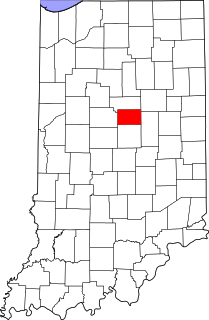
This is a list of the National Register of Historic Places listings in Tipton County, Indiana.

National Register of Historic Places listings in Kosciusko County, Indiana

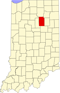
This is a list of the National Register of Historic Places listings in Kosciusko County, Indiana.

References

  1. The latitude and longitude information provided in this table was derived originally from the National Register Information System, which has been found to be fairly accurate for about 99% of listings. Some locations in this table may have been corrected to current GPS standards.
  2. National Park Service, United States Department of the Interior, "National Register of Historic Places: Weekly List Actions", retrieved April 23, 2021.
  3. Numbers represent an alphabetical ordering by significant words. Various colorings, defined here, differentiate National Historic Landmarks and historic districts from other NRHP buildings, structures, sites or objects.
  4. "National Register Information System". National Register of Historic Places . National Park Service. March 13, 2009.
  5. The eight-digit number below each date is the number assigned to each location in the National Register Information System database, which can be viewed by clicking the number.