National Register of Historic Places listings in Hendricks County, Indiana

Last updated

Location of Hendricks County in Indiana Map of Indiana highlighting Hendricks County.svg
Location of Hendricks County in Indiana

This is a list of the National Register of Historic Places listings in Hendricks County, Indiana.

Contents

This is intended to be a complete list of the properties and districts on the National Register of Historic Places in Hendricks County, Indiana, United States. Latitude and longitude coordinates are provided for many National Register properties and districts; these locations may be seen together in a map. [1]

There are 20 properties and districts listed on the National Register in the county, and two former listings.

Properties and districts located in incorporated areas display the name of the municipality, while properties and districts in unincorporated areas display the name of their civil township. Properties and districts split between multiple jurisdictions display the names of all jurisdictions.


    This National Park Service list is complete through NPS recent listings posted December 8, 2023. [2]

Map all coordinates using: OpenStreetMap

Current listings

[3] Name on the Register [4] ImageDate listed [5] Location City or townDescription
1 Ora Adams House
Ora Adams House Ora Adams House.jpg
Ora Adams House
June 17, 2009
(#09000425)
301-303 E. Main St.
39°45′39″N86°31′13″W / 39.76075°N 86.520361°W / 39.76075; -86.520361 (Ora Adams House)
Danville
2 Amo THI & E Interurban Depot/Substation
Amo THI & E Interurban Depot/Substation Amo THI & E Interurban Depot-Substation.jpg
Amo THI & E Interurban Depot/Substation
January 25, 2007
(#06001294)
4985 Railroad St.
39°41′18″N86°36′48″W / 39.688333°N 86.613333°W / 39.688333; -86.613333 (Amo THI & E Interurban Depot/Substation)
Amo
3 Forest W. and Jeannette Wales Blanton House
Forest W. and Jeannette Wales Blanton House Forest W. and Jeannette Wales Blanton House.jpg
Forest W. and Jeannette Wales Blanton House
September 12, 2016
(#16000612)
625 N. Washington St.
39°46′14″N86°31′23″W / 39.770556°N 86.523056°W / 39.770556; -86.523056 (Forest W. and Jeannette Wales Blanton House)
Danville
4 Leander Campbell House
Leander Campbell House Leander Campbell House.jpg
Leander Campbell House
September 28, 2003
(#03000981)
498 E. Broadway St.
39°45′29″N86°30′58″W / 39.758056°N 86.516111°W / 39.758056; -86.516111 (Leander Campbell House)
Danville
5 Danville Courthouse Square Historic District
Danville Courthouse Square Historic District Hendricks County Indiana Courthouse.jpg
Danville Courthouse Square Historic District
December 27, 2010
(#02001559)
Roughly bounded by Clinton, Tennessee, Broadway, and Cross Sts.
39°45′37″N86°31′26″W / 39.760278°N 86.523889°W / 39.760278; -86.523889 (Danville Courthouse Square Historic District)
Danville
6 Danville Main Street Historic District
Danville Main Street Historic District Danville Main Street Historic District.jpg
Danville Main Street Historic District
September 8, 1994
(#94001109)
Bounded by East, Main, Cross, and Marion Sts.
39°45′37″N86°31′42″W / 39.760278°N 86.528333°W / 39.760278; -86.528333 (Danville Main Street Historic District)
Danville
7 Dr. Jeremiah and Ann Jane DePew House
Dr. Jeremiah and Ann Jane DePew House Dr. Jeremiah and Ann Jane DePew House.jpg
Dr. Jeremiah and Ann Jane DePew House
September 20, 2006
(#06000850)
292 E. Broadway St.
39°45′33″N86°31′14″W / 39.759167°N 86.520556°W / 39.759167; -86.520556 (Dr. Jeremiah and Ann Jane DePew House)
Danville
8 Hendricks County Bridge Number 316
Hendricks County Bridge Number 316 Hendricks County Bridge 316 northern side.jpg
Hendricks County Bridge Number 316
March 26, 2003
(#03000140)
Center Rd., Friendship Gardens over White Lick Creek
39°41′47″N86°24′07″W / 39.696389°N 86.401944°W / 39.696389; -86.401944 (Hendricks County Bridge Number 316)
Plainfield
9 Hendricks County Jail and Sheriff's Residence
Hendricks County Jail and Sheriff's Residence Hendricks County Jail and Sheriff's Residence.jpg
Hendricks County Jail and Sheriff's Residence
June 30, 1983
(#83000125)
170 S. Washington St.
39°45′32″N86°31′27″W / 39.758889°N 86.524167°W / 39.758889; -86.524167 (Hendricks County Jail and Sheriff's Residence)
Danville
10 Hendricks County Poor Asylum December 3, 2018
(#100003181)
865 E. Main St.
39°45′28″N86°30′18″W / 39.757778°N 86.505000°W / 39.757778; -86.505000 (Hendricks County Poor Asylum)
Center Township
11 Joel Jessup Farm
Joel Jessup Farm Joel Jessup Farmhouse.jpg
Joel Jessup Farm
August 14, 1998
(#98001049)
County Road 800S near County Road 1050E, northwest of Friendswood
39°38′44″N86°20′09″W / 39.645556°N 86.335833°W / 39.645556; -86.335833 (Joel Jessup Farm)
Guilford Township
12 Noah and Hannah Hadley Kellum House
Noah and Hannah Hadley Kellum House Noah and Hannah Hadley Kellum House.jpg
Noah and Hannah Hadley Kellum House
March 3, 1995
(#95000204)
7290 S. County Road 1050E, northwest of Friendswood
39°39′25″N86°20′11″W / 39.656944°N 86.336389°W / 39.656944; -86.336389 (Noah and Hannah Hadley Kellum House)
Guilford Township
13 John W. McClain House
John W. McClain House John W. McClain House.jpg
John W. McClain House
June 22, 2004
(#04000633)
1445 S. County Road 525E, southwest of Avon
39°44′59″N86°25′44″W / 39.749722°N 86.428889°W / 39.749722; -86.428889 (John W. McClain House)
Washington Township
14 McCormack-Bowman House
McCormack-Bowman House McCormack-Bowman House.jpg
McCormack-Bowman House
March 20, 1995
(#95000200)
County Road 200W, 0.5 miles south of its junction with U.S. Route 40 and southwest of Clayton
39°38′50″N86°33′37″W / 39.647222°N 86.560278°W / 39.647222; -86.560278 (McCormack-Bowman House)
Franklin Township
15 A.A. Parsons Farmstead
A.A. Parsons Farmstead A.A. Parsons Farmstead fields.jpg
A.A. Parsons Farmstead
September 30, 2014
(#14000803)
1739 S625E
39°44′14″N86°25′10″W / 39.737222°N 86.419444°W / 39.737222; -86.419444 (A.A. Parsons Farmstead)
Washington Township
16 Plainfield Historic District
Plainfield Historic District Main near Center in Plainfield.jpg
Plainfield Historic District
March 31, 2010
(#10000121)
Roughly bounded by Lincoln St to the north; S. East St. to the east; Ash St. to the south; and S. Mill St to the west
39°42′11″N86°24′09″W / 39.702961°N 86.402486°W / 39.702961; -86.402486 (Plainfield Historic District)
Plainfield
17 Sugar Grove Meetinghouse and Cemetery
Sugar Grove Meetinghouse and Cemetery Sugar Grove Meetinghouse.jpg
Sugar Grove Meetinghouse and Cemetery
September 22, 2000
(#00001137)
Junction of County Roads 700E and 600S
39°40′29″N86°24′01″W / 39.674722°N 86.400278°W / 39.674722; -86.400278 (Sugar Grove Meetinghouse and Cemetery)
Guilford Township
18 THI and E Interurban Depot-Substation
THI and E Interurban Depot-Substation THI and E Interurban Depot-Substation in Plainfield.jpg
THI and E Interurban Depot-Substation
December 19, 2002
(#02001562)
401 S. Vine St.
39°42′01″N86°24′01″W / 39.700278°N 86.400278°W / 39.700278; -86.400278 (THI and E Interurban Depot-Substation)
Plainfield
19 Twin Bridges
Twin Bridges County Bridge 178, Twin Bridges.jpg
Twin Bridges
March 15, 2000
(#00000200)
County Road 150E over White Lick Creek
39°45′15″N86°30′15″W / 39.754167°N 86.504167°W / 39.754167; -86.504167 (Twin Bridges)
Danville
20 Wilson-Courtney House
Wilson-Courtney House Wilson-Courtney House.jpg
Wilson-Courtney House
February 9, 1984
(#84001044)
10 Cartersburg Rd.
39°45′10″N86°31′14″W / 39.752778°N 86.520556°W / 39.752778; -86.520556 (Wilson-Courtney House)
Danville

Former listings

[3] Name on the RegisterImageDate listedDate removedLocationCity or townDescription
1 Kellum-Jessup-Chandler Farm
Kellum-Jessup-Chandler Farm Kellum-Jessup-Chandler Farm.jpg
Kellum-Jessup-Chandler Farm
September 8, 1994
(#94001111)
November 15, 20216726 S. White Lick Creek Rd., southeast of Plainfield
39°39′55″N86°20′36″W / 39.665278°N 86.343333°W / 39.665278; -86.343333 (Kellum-Jessup-Chandler Farm)
Guilford Township
2 Smith Farm
Smith Farm Smith Farmhouse near Plainfield.jpg
Smith Farm
December 19, 2007
(#07001279)
December 7, 20232698 S. County Road 900E, northeast of Plainfield
39°43′34″N86°21′42″W / 39.726111°N 86.361667°W / 39.726111; -86.361667 (Smith Farm)
Washington Township

See also

Related Research Articles

<span class="mw-page-title-main">National Register of Historic Places listings in Wayne County, Indiana</span>

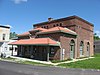
This is a list of the National Register of Historic Places listings in Wayne County, Indiana.

<span class="mw-page-title-main">National Register of Historic Places listings in Bartholomew County, Indiana</span>

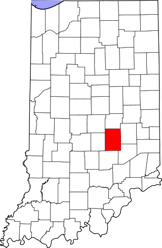
This is a list of the National Register of Historic Places listings in Bartholomew County, Indiana.

<span class="mw-page-title-main">National Register of Historic Places listings in Morgan County, Indiana</span>

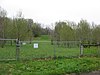
This is a list of the National Register of Historic Places listings in Morgan County, Indiana.

<span class="mw-page-title-main">National Register of Historic Places listings in Adams County, Indiana</span>

This is a list of the National Register of Historic Places listings in Adams County, Indiana.

<span class="mw-page-title-main">National Register of Historic Places listings in Blackford County, Indiana</span>

This is a list of the National Register of Historic Places listings in Blackford County, Indiana.

<span class="mw-page-title-main">National Register of Historic Places listings in Boone County, Indiana</span>

This is a list of the National Register of Historic Places listings in Boone County, Indiana.

<span class="mw-page-title-main">National Register of Historic Places listings in Cass County, Indiana</span>

This is a list of the National Register of Historic Places listings in Cass County, Indiana.

<span class="mw-page-title-main">National Register of Historic Places listings in Montgomery County, Indiana</span>

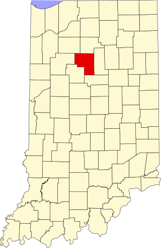
This is a list of the National Register of Historic Places listings in Montgomery County, Indiana.

<span class="mw-page-title-main">National Register of Historic Places listings in Scott County, Indiana</span>

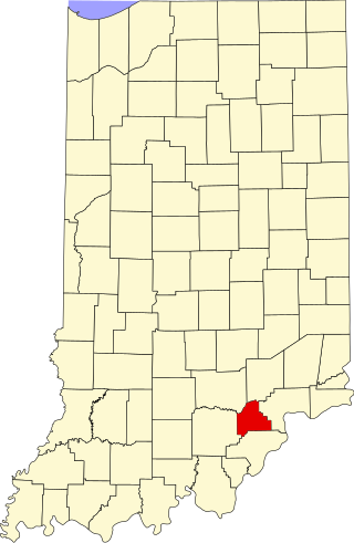
This is a list of the National Register of Historic Places listings in Scott County, Indiana.

<span class="mw-page-title-main">National Register of Historic Places listings in Decatur County, Indiana</span>

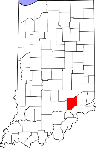
This is a list of the National Register of Historic Places listings in Decatur County, Indiana.

<span class="mw-page-title-main">National Register of Historic Places listings in Dubois County, Indiana</span>

This is a list of the National Register of Historic Places listings in Dubois County, Indiana.

<span class="mw-page-title-main">National Register of Historic Places listings in Fountain County, Indiana</span>

This is a list of the National Register of Historic Places listings in Fountain County, Indiana.

<span class="mw-page-title-main">National Register of Historic Places listings in Jefferson County, Indiana</span>

This is a list of the National Register of Historic Places listings in Jefferson County, Indiana.

<span class="mw-page-title-main">National Register of Historic Places listings in Jennings County, Indiana</span>

This is a list of the National Register of Historic Places listings in Jennings County, Indiana.

<span class="mw-page-title-main">National Register of Historic Places listings in Newton County, Indiana</span>

This is a list of the National Register of Historic Places listings in Newton County, Indiana.

<span class="mw-page-title-main">National Register of Historic Places listings in Orange County, Indiana</span>

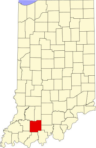
This is a list of the National Register of Historic Places listings in Orange County, Indiana.

<span class="mw-page-title-main">National Register of Historic Places listings in Putnam County, Indiana</span>

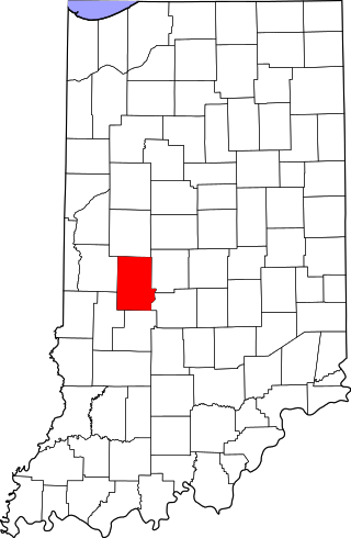
This is a list of the National Register of Historic Places listings in Putnam County, Indiana.

<span class="mw-page-title-main">National Register of Historic Places listings in Shelby County, Indiana</span>

This is a list of the National Register of Historic Places listings in Shelby County, Indiana.

<span class="mw-page-title-main">National Register of Historic Places listings in Grant County, Indiana</span>

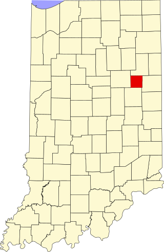
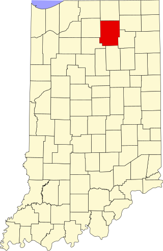
This is a list of the National Register of Historic Places listings in Grant County, Indiana.

<span class="mw-page-title-main">National Register of Historic Places listings in Kosciusko County, Indiana</span>

This is a list of the National Register of Historic Places listings in Kosciusko County, Indiana.

References

  1. The latitude and longitude information provided in this table was derived originally from the National Register Information System, which has been found to be fairly accurate for about 99% of listings. Some locations in this table may have been corrected to current GPS standards.
  2. National Park Service, United States Department of the Interior, "National Register of Historic Places: Weekly List Actions", retrieved December 8, 2023.
  3. 1 2 Numbers represent an alphabetical ordering by significant words. Various colorings, defined here, differentiate National Historic Landmarks and historic districts from other NRHP buildings, structures, sites or objects.
  4. "National Register Information System". National Register of Historic Places . National Park Service. March 13, 2009.
  5. The eight-digit number below each date is the number assigned to each location in the National Register Information System database, which can be viewed by clicking the number.