National Register of Historic Places listings in DeKalb County, Indiana

Last updated

Location of DeKalb County in Indiana Map of Indiana highlighting DeKalb County.svg
Location of DeKalb County in Indiana

This is a list of the National Register of Historic Places listings in DeKalb County, Indiana.

Contents

This is intended to be a complete list of the properties and districts on National Register of Historic Places in DeKalb County, Indiana, United States. Latitude and longitude coordinates are provided for many National Register properties and districts; these locations may be seen together in a map. [1]

There are 29 properties and districts listed on the National Register in the county, including 1 National Historic Landmark.

Properties and districts located in incorporated areas display the name of the municipality, while properties and districts in unincorporated areas display the name of their civil township. Properties and districts split between multiple jurisdictions display the names of all jurisdictions.


    This National Park Service list is complete through NPS recent listings posted March 4, 2022. [2]

Map all coordinates using: OpenStreetMap  
Download coordinates as: KML

Current listings

[3] Name on the Register [4] ImageDate listed [5] Location City or townDescription
1 Auburn Community Mausoleum
Auburn Community Mausoleum Auburn Community Mausoleum.jpg
Auburn Community Mausoleum
March 24, 2014
(#14000069)
1431 Center St.
41°21′24″N85°02′58″W / 41.356528°N 85.049306°W / 41.356528; -85.049306 (Auburn Community Mausoleum)
Auburn
2 Auburn Cord Duesenberg Automobile Facility
Auburn Cord Duesenberg Automobile Facility Auburn Cord Duesenberg Museum 2004.jpg
Auburn Cord Duesenberg Automobile Facility
September 21, 1978
(#78000029)
1600 S. Wayne St.
41°21′21″N85°03′26″W / 41.355833°N 85.057222°W / 41.355833; -85.057222 (Auburn Cord Duesenberg Automobile Facility)
Auburn
3 Samuel Bevier House
Samuel Bevier House Samuel Bevier House.jpg
Samuel Bevier House
May 6, 1983
(#83000014)
County Roads 11 and 52, south of Garrett
41°20′13″N85°08′15″W / 41.336806°N 85.137500°W / 41.336806; -85.137500 (Samuel Bevier House)
Keyser Township
4 Joseph Bowman Farmhouse
Joseph Bowman Farmhouse Joseph Bowman Farmhouse.jpg
Joseph Bowman Farmhouse
May 6, 1983
(#83000013)
County Roads 19 and 40, northeast of Garrett
41°22′52″N85°05′55″W / 41.381111°N 85.098611°W / 41.381111; -85.098611 (Joseph Bowman Farmhouse)
Keyser Township
5 Breechbill-Davidson House
Breechbill-Davidson House Breechbill-Davidson House.jpg
Breechbill-Davidson House
May 6, 1983
(#83000012)
State Road 8 and County Road 7, northwest of Garrett
41°22′02″N85°09′21″W / 41.367222°N 85.155833°W / 41.367222; -85.155833 (Breechbill-Davidson House)
Keyser Township
6 Brethren in Christ Church
Brethren in Christ Church Brethren in Christ Church near Garrett.jpg
Brethren in Christ Church
May 6, 1983
(#83000011)
County Road 7, northwest of Garrett
41°22′11″N85°09′18″W / 41.369861°N 85.155000°W / 41.369861; -85.155000 (Brethren in Christ Church)
Keyser Township
7 Butler Community Mausoleum
Butler Community Mausoleum Butler Community Mausoleum.jpg
Butler Community Mausoleum
March 25, 2014
(#14000070)
County Road 28 E., east of Butler
41°25′49″N84°50′59″W / 41.430278°N 84.849722°W / 41.430278; -84.849722 (Butler Community Mausoleum)
Stafford Township
8 Orin Clark House
Orin Clark House Orin Clark House.jpg
Orin Clark House
May 6, 1983
(#83000010)
County Roads 3 and 48, west of Garrett
41°21′03″N85°10′34″W / 41.350833°N 85.176111°W / 41.350833; -85.176111 (Orin Clark House)
Keyser Township
9 William Cornell Homestead
William Cornell Homestead William Cornell Homestead.jpg
William Cornell Homestead
August 14, 1973
(#73000015)
Southwest of Auburn off State Road 427
41°16′44″N85°05′28″W / 41.278889°N 85.091111°W / 41.278889; -85.091111 (William Cornell Homestead)
Butler Township
10 DeKalb County Home and Barn
DeKalb County Home and Barn DeKalb County Home near Garrett.jpg
DeKalb County Home and Barn
May 6, 1983
(#83000015)
County Road 40, northeast of Garrett
41°22′54″N85°04′59″W / 41.381667°N 85.083056°W / 41.381667; -85.083056 (DeKalb County Home and Barn)
Keyser Township
11 Downtown Auburn Historic District
Downtown Auburn Historic District Auburn-indiana-courthouse-night.jpg
Downtown Auburn Historic District
September 10, 1986
(#86002858)
Roughly bounded by E. and W. 4th, N. and S. Cedar, E. 12th, and N. and S. Jackson Sts.
41°22′00″N85°03′18″W / 41.366667°N 85.055000°W / 41.366667; -85.055000 (Downtown Auburn Historic District)
Auburn
12 Downtown Butler Historic District
Downtown Butler Historic District Butler Masonic Lodge.jpg
Downtown Butler Historic District
December 7, 2001
(#01001347)
Roughly the 100 and 200 blocks of S. Broadway
41°25′45″N84°52′18″W / 41.429167°N 84.871667°W / 41.429167; -84.871667 (Downtown Butler Historic District)
Butler
13 Eckhart Public Library and Park
Eckhart Public Library and Park Eckhart Public Library.jpg
Eckhart Public Library and Park
November 20, 1981
(#81000009)
603 S. Jackson St.
41°21′50″N85°03′27″W / 41.363889°N 85.057500°W / 41.363889; -85.057500 (Eckhart Public Library and Park)
Auburn
14 William Fountain House
William Fountain House William Fountain House.jpg
William Fountain House
May 6, 1983
(#83000021)
State Road 8, northwest of Garrett
41°21′58″N85°10′38″W / 41.366111°N 85.177222°W / 41.366111; -85.177222 (William Fountain House)
Keyser Township
15 Garrett Community Mausoleum
Garrett Community Mausoleum Garrett Community Mausoleum.jpg
Garrett Community Mausoleum
March 25, 2014
(#14000071)
S. Hamsher St.
41°20′43″N85°08′38″W / 41.345139°N 85.143889°W / 41.345139; -85.143889 (Garrett Community Mausoleum)
Garrett
16 Garrett Historic District
Garrett Historic District Franklin north of Dennis in Garrett.jpg
Garrett Historic District
May 6, 1983
(#83000121)
Roughly bounded by Railroad, Britton, Warfield, and Hamsher Sts., and 3rd Ave.
41°20′43″N85°08′06″W / 41.345278°N 85.135°W / 41.345278; -85.135 (Garrett Historic District)
Garrett
17 Gump House
Gump House Gump House near Garrett.jpg
Gump House
May 6, 1983
(#83000020)
State Road 8, northwest of Garrett
41°21′58″N85°11′23″W / 41.366111°N 85.189722°W / 41.366111; -85.189722 (Gump House)
Keyser Township
18 J.H. Haag House
J.H. Haag House J.H. Haag House.jpg
J.H. Haag House
May 6, 1983
(#83000019)
County Road 54
41°19′46″N85°08′08″W / 41.329583°N 85.135556°W / 41.329583; -85.135556 (J.H. Haag House)
Garrett
19 Edward Kelham House
Edward Kelham House Edward Kelham House.jpg
Edward Kelham House
May 6, 1983
(#83000018)
County Road 48, west of Garrett
41°21′07″N85°11′20″W / 41.351944°N 85.188889°W / 41.351944; -85.188889 (Edward Kelham House)
Keyser Township
20 Keyser Township School 8
Keyser Township School 8 Keyser Township School 8.jpg
Keyser Township School 8
May 6, 1983
(#83000017)
E. Quincy St.
41°21′06″N85°07′03″W / 41.351667°N 85.1175°W / 41.351667; -85.1175 (Keyser Township School 8)
Garrett
21 Charles Lehmback Farmstead
Charles Lehmback Farmstead Charles Lehmback Farmstead.jpg
Charles Lehmback Farmstead
May 6, 1983
(#83000016)
County Road 15, east of Garrett
41°20′37″N85°07′01″W / 41.343611°N 85.116944°W / 41.343611; -85.116944 (Charles Lehmback Farmstead)
Keyser Township
22 Mountz House
Mountz House Mountz House.jpg
Mountz House
September 11, 1979
(#79000013)
507 E. Houston St.
41°20′53″N85°07′49″W / 41.348056°N 85.130278°W / 41.348056; -85.130278 (Mountz House)
Garrett
23 Henry Peters House
Henry Peters House Henry Peters House.jpg
Henry Peters House
May 6, 1983
(#83000022)
201 N. 6th St.
41°21′06″N85°07′11″W / 41.351667°N 85.119722°W / 41.351667; -85.119722 (Henry Peters House)
Garrett
24 Rakestraw House
Rakestraw House Rakestraw House in Keyser Township.jpg
Rakestraw House
May 6, 1983
(#83000024)
County Road 19, northeast of Garrett
41°22′11″N85°05′54″W / 41.369722°N 85.098333°W / 41.369722; -85.098333 (Rakestraw House)
Keyser Township
25 Henry Shull Farmhouse Inn
Henry Shull Farmhouse Inn Site of the Henry Shull Farmhouse Inn.jpg
Henry Shull Farmhouse Inn
May 6, 1983
(#83000023)
County Road 11-A, southeast of Garrett
41°19′36″N85°05′23″W / 41.326667°N 85.089722°W / 41.326667; -85.089722 (Henry Shull Farmhouse Inn)
Keyser Township
26 Spencerville Covered Bridge
Spencerville Covered Bridge Spencerville Covered Bridge.jpg
Spencerville Covered Bridge
April 2, 1981
(#81000010)
County Road 68 at Spencerville
41°16′53″N84°54′53″W / 41.281389°N 84.914722°W / 41.281389; -84.914722 (Spencerville Covered Bridge)
Spencer Township
27 Waterloo Community Mausoleum
Waterloo Community Mausoleum Waterloo Community Mausoleum.jpg
Waterloo Community Mausoleum
March 25, 2014
(#14000072)
N. Center St.
41°26′14″N85°01′23″W / 41.437222°N 85.022917°W / 41.437222; -85.022917 (Waterloo Community Mausoleum)
Waterloo
28 John Wilderson House
John Wilderson House John Wilderson House.jpg
John Wilderson House
May 6, 1983
(#83000025)
1349 S. Cowen St.
41°20′01″N85°08′12″W / 41.333611°N 85.136667°W / 41.333611; -85.136667 (John Wilderson House)
Garrett
29 Maria and Franklin Wiltrout Polygonal Barn
Maria and Franklin Wiltrout Polygonal Barn Polygonal Barn1.JPG
Maria and Franklin Wiltrout Polygonal Barn
April 2, 1993
(#93000183)
0209 County Road 16, northwest of Corunna
41°28′04″N85°11′02″W / 41.467639°N 85.183889°W / 41.467639; -85.183889 (Maria and Franklin Wiltrout Polygonal Barn)
Fairfield Township

See also

Related Research Articles

National Register of Historic Places listings in Allen County, Indiana

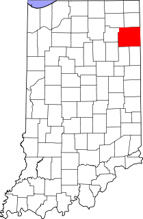
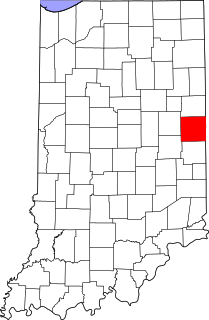
This is a list of the National Register of Historic Places listings in Allen County, Indiana.

National Register of Historic Places listings in Vanderburgh County, Indiana

This is a list of the National Register of Historic Places listings in Vanderburgh County, Indiana.

National Register of Historic Places listings in Wayne County, Indiana

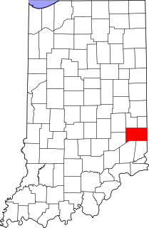
This is a list of the National Register of Historic Places listings in Wayne County, Indiana.

National Register of Historic Places listings in Dearborn County, Indiana

This is a list of the National Register of Historic Places listings in Dearborn County, Indiana.

National Register of Historic Places listings in Adams County, Indiana

This is a list of the National Register of Historic Places listings in Adams County, Indiana.

National Register of Historic Places listings in Benton County, Indiana

This is a list of the National Register of Historic Places listings in Benton County, Indiana.

National Register of Historic Places listings in Whitley County, Indiana

This is a list of the National Register of Historic Places listings in Whitley County, Indiana.

National Register of Historic Places listings in Franklin County, Indiana

This is a list of the National Register of Historic Places listings in Franklin County, Indiana.

National Register of Historic Places listings in Gibson County, Indiana

This is a list of the National Register of Historic Places listings in Gibson County, Indiana.

National Register of Historic Places listings in Greene County, Indiana

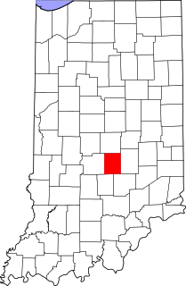
This is a list of the National Register of Historic Places listings in Greene County, Indiana.

National Register of Historic Places listings in Henry County, Indiana

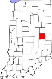
This is a list of the National Register of Historic Places listings in Henry County, Indiana.

National Register of Historic Places listings in Howard County, Indiana

This is a list of the National Register of Historic Places listings in Howard County, Indiana.

National Register of Historic Places listings in Jay County, Indiana

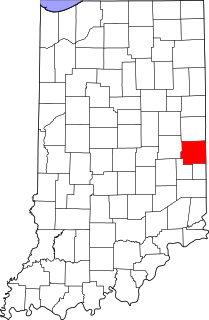
This is a list of the National Register of Historic Places listings in Jay County, Indiana.

National Register of Historic Places listings in Johnson County, Indiana

This is a list of the National Register of Historic Places listings in Johnson County, Indiana.

National Register of Historic Places listings in Noble County, Indiana

This is a list of the National Register of Historic Places listings in Noble County, Indiana.

National Register of Historic Places listings in Orange County, Indiana

This is a list of the National Register of Historic Places listings in Orange County, Indiana.

National Register of Historic Places listings in Randolph County, Indiana

This is a list of the National Register of Historic Places listings in Randolph County, Indiana.

National Register of Historic Places listings in Steuben County, Indiana

This is a list of the National Register of Historic Places listings in Steuben County, Indiana.

National Register of Historic Places listings in Grant County, Indiana

This is a list of the National Register of Historic Places listings in Grant County, Indiana.

National Register of Historic Places listings in Union County, Indiana

This is a list of the National Register of Historic Places listings in Union County, Indiana.

References

  1. The latitude and longitude information provided in this table was derived originally from the National Register Information System, which has been found to be fairly accurate for about 99% of listings. Some locations in this table may have been corrected to current GPS standards.
  2. National Park Service, United States Department of the Interior, "National Register of Historic Places: Weekly List Actions", retrieved March 4, 2022.
  3. Numbers represent an alphabetical ordering by significant words. Various colorings, defined here, differentiate National Historic Landmarks and historic districts from other NRHP buildings, structures, sites or objects.
  4. "National Register Information System". National Register of Historic Places . National Park Service. March 13, 2009.
  5. The eight-digit number below each date is the number assigned to each location in the National Register Information System database, which can be viewed by clicking the number.