Eel River Township, Hendricks County, Indiana

Last updated

Eel River Township
Map highlighting Eel River Township, Hendricks County, Indiana.svg
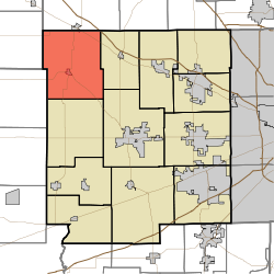
Location in Hendricks County
Coordinates: 39°52′19″N86°37′50″W / 39.87194°N 86.63056°W / 39.87194; -86.63056
Country United States
State Indiana
County Hendricks
Government
  Type Indiana township
Area
  Total
42.54 sq mi (110.18 km2)
  Land42.54 sq mi (110.18 km2)
  Water0 sq mi (0 km2)  0%
Elevation
919 ft (280 m)
Population
 (2020) [1]
  Total
1,707
  Density39.1/sq mi (15.1/km2)
GNIS feature ID0453274

Eel River Township is one of twelve townships in Hendricks County, Indiana, United States. As of the 2010 census, its population was 1,662. [2]

Contents

History

Eel River Township was organized in about 1828. [3]

Geography

Eel River Township covers an area of 42.54 square miles (110.2 km2). The streams of East Fork Big Walnut Creek, Hunt Creek, Middle Fork Big Walnut Creek and Ramp Run run through this township.

Cities and towns

Adjacent townships

Cemeteries

The township contains sixteen cemeteries: Adams, Campbell, Devenport, Fairview, Fleece, Fullen, Gossett, Hypes, Kidd Farm, North Salem Baptist, Page, Pennington, Richardson, Roundtown, Trotter and Zimmerman.

Major highways

Airports and landing strips

Education

It is in the North West Hendricks School Corporation. [4]

References

  1. "Census Bureau profile: Eel River Township, Hancock County, Indiana". United States Census Bureau. May 2023. Retrieved March 21, 2024.
  2. "U.S. Census website" . Retrieved July 20, 2008.
  3. Hadley, John Vestal (1914). History of Hendricks County, Indiana: Her People, Industries and Institutions. B.F. Bowen. pp.  70.
  4. Geography Division (December 18, 2020). 2020 CENSUS - SCHOOL DISTRICT REFERENCE MAP: Hendricks County, IN (PDF) (Map). U.S. Census Bureau . Retrieved June 7, 2024. - Text list