Burns Harbor, Indiana

Last updated

Burns Harbor, Indiana
Town of Burns Harbor
Villageinburnsharbor arial.jpg
Porter County Indiana Incorporated and Unincorporated areas Burns Harbor Highlighted 1809370.svg
Location of Burns Harbor in Porter County, Indiana.
Coordinates: 41°37′43″N87°07′28″W / 41.62861°N 87.12444°W / 41.62861; -87.12444
Country United States
State Indiana
County Porter
Township Westchester
Area
[1]
  Total6.44 sq mi (16.67 km2)
  Land6.44 sq mi (16.67 km2)
  Water0.00 sq mi (0.00 km2)
Elevation
[2]
630 ft (190 m)
Population
 (2020)
  Total2,055
  Density319.25/sq mi (123.27/km2)
Time zone UTC-6 (CST)
  Summer (DST) UTC-5 (CDT)
ZIP code
46304
Area code 219
FIPS code 18-09370 [3]
GNIS feature ID2396621 [2]
Website http://www.burnsharbor-in.gov

Burns Harbor is a town in Westchester Township, Porter County, Indiana, United States on the shores of Lake Michigan in Northwest Indiana. It is part of the Chicago metropolitan area. The population was 1,156 at the 2010 census. Burns Harbor is located adjacent to the Indiana Dunes, an area that conservationists have fought hard to preserve. [4] [5] [6]

Contents

History

Burns Harbor was founded in 1966. [7] The town took its name from a local port which was named for the harbor's promoter Randall W. Burns. [8]

Geography

According to the 2010 census, Burns Harbor has a total area of 6.78 square miles (17.56 km2), of which 6.66 square miles (17.25 km2) (or 98.23%) is land and 0.12 square miles (0.31 km2) (or 1.77%) is water. [9]

Demographics

Historical population
CensusPop.Note
1970 1,284
1980 920−28.3%
1990 786−14.6%
2000 766−2.5%
2010 1,15650.9%
2020 2,05577.8%
Source: US Census Bureau

2010 census

As of the census [10] of 2010, there were 1,156 people, 456 households, and 305 families living in the town. The population density was 173.3 inhabitants per square mile (66.9/km2). There were 495 housing units at an average density of 74.2 per square mile (28.6/km2). The racial makeup of the town was 95.4% White, 1.8% African American, 0.3% Native American, 0.3% Asian, 1.1% from other races, and 1.1% from two or more races. Hispanic or Latino of any race were 5.8% of the population.

There were 456 households, of which 37.3% had children under the age of 18 living with them, 51.5% were married couples living together, 10.3% had a female householder with no husband present, 5.0% had a male householder with no wife present, and 33.1% were non-families. 26.1% of all households were made up of individuals, and 7.4% had someone living alone who was 65 years of age or older. The average household size was 2.54 and the average family size was 3.10.

The median age in the town was 34.6 years. 26.2% of residents were under the age of 18; 6.4% were between the ages of 18 and 24; 31% were from 25 to 44; 25.6% were from 45 to 64; and 10.6% were 65 years of age or older. The gender makeup of the town was 50.8% male and 49.2% female.

2000 census

As of the census [3] of 2000, there were 766 people, 303 households, and 219 families living in the town. The population density was 112.1 inhabitants per square mile (43.3/km2). There were 323 housing units at an average density of 47.3 per square mile (18.3/km2). The racial makeup of the town was 94.26% White, 0.26% African American, 1.17% Native American, 1.04% Asian, 0.39% from other races, and 2.87% from two or more races. Hispanic or Latino of any race were 4.31% of the population.

There were 303 households, out of which 30.7% had children under the age of 18 living with them, 57.1% were married couples living together, 7.9% had a female householder with no husband present, and 27.4% were non-families. 22.8% of all households were made up of individuals, and 7.3% had someone living alone who was 65 years of age or older. The average household size was 2.53 and the average family size was 2.95.

In the town, the population was spread out, with 24.7% under the age of 18, 8.0% from 18 to 24, 28.5% from 25 to 44, 28.3% from 45 to 64, and 10.6% who were 65 years of age or older. The median age was 38 years. For every 100 females, there were 103.7 males. For every 100 females age 18 and over, there were 111.4 males.

The median income for a household in the town was $53,929, and the median income for a family was $57,188. Males had a median income of $43,393 versus $22,143 for females. The per capita income for the town was $23,344. About 4.2% of families and 6.3% of the population were below the poverty line, including 5.4% of those under age 18 and 5.6% of those age 65 or over.

Steel manufacturing is a key industry in Burns Harbor The Burns Harbor Mill.jpg
Steel manufacturing is a key industry in Burns Harbor

Transportation

Burns Harbor benefits from close access to many major forms of transportation.
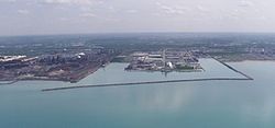
Airports

Commuter Rail

Ports

Highways

Education

Burns Harbor is served by Duneland Schools (http://www.duneland.k12.in.us) providing education for grades Kindergarten through 12, and is in close proximity to many higher education facilities including:

The rock band Turnerjoy practiced in the basement of a mobile home company in Burns Harbor. The band is the subject of the 2020 documentary Get Out of Home and scenes from the movie take place in Burns Harbor. [11]

Related Research Articles

<span class="mw-page-title-main">Porter County, Indiana</span> County in Indiana, United States

Porter County is a county in the U.S. state of Indiana. As of 2020, the population was 173,215, making it the 10th most populous county in Indiana. The county seat is Valparaiso. The county is part of Northwest Indiana, as well as the Chicago metropolitan area. Porter County is the site of much of the Indiana Dunes, an area of ecological significance. The Hour Glass Museum in Ogden Dunes documents the region's ecological significance.

<span class="mw-page-title-main">East Chicago, Indiana</span> City in Indiana, United States

East Chicago is a city in Lake County, Indiana, United States. The population was 26,370 at the 2020 census. Centered around heavy industry, the city is home to the Indiana Harbor and Ship Canal, an artificial freshwater harbor characterized by industrial and manufacturing activity.

<span class="mw-page-title-main">Griffith, Indiana</span> Town in Indiana, United States

Griffith is a town in North and St. John townships in Lake County, Indiana, United States. It is a part of the Chicago metropolitan area. The population was 16,420 in 2020. The town's population is currently declining at a rate of 0.69% annually. Griffith is the town with the 11th largest population and 17th largest town by area in the State of Indiana.

<span class="mw-page-title-main">Merrillville, Indiana</span> Town in Indiana, United States

Merrillville is a town in Ross Township, Lake County, Indiana, United States. The population was 35,246 at the 2010 census. Merrillville is in east-central Lake County, in the Chicago metropolitan area. On January 1, 2015, Merrillville became the most populated town in Indiana, as Fishers in Hamilton County was converted from a town to a city. The town serves as a major shopping hub for Northwest Indiana.

<span class="mw-page-title-main">Schererville, Indiana</span> Town in Indiana, United States

Schererville is a town in St. John Township, Lake County, Indiana, United States. The population was 29,646 at the 2020 census It is a suburb of Chicago, located 30 miles south of the city.

<span class="mw-page-title-main">Michiana Shores, Indiana</span> Town in Indiana, United States

Michiana Shores is a town in Springfield and Michigan townships, LaPorte County, Indiana, United States. The population was 313 at the 2010 census. It is included in the Michigan City, Indiana-La Porte, Indiana Metropolitan Statistical Area. Michiana Shores is located in northwesternmost Springfield Township, and is the township's sole incorporated community.

<span class="mw-page-title-main">Michigan City, Indiana</span> City in Indiana, United States

Michigan City is a city in LaPorte County, Indiana, United States. It had a population of 32,075 at the 2020 census. Located along Lake Michigan in the Michiana region, the city is about 45 miles (72 km) east of Chicago and is 40 miles (64 km) west of South Bend.

<span class="mw-page-title-main">Trail Creek, Indiana</span> Town in Indiana, United States

Trail Creek is a town in Coolspring and Michigan townships, LaPorte County, Indiana, United States. The population was 2,052 at the 2010 census. It is included in the Michigan City, Indiana-La Porte, Indiana Metropolitan Statistical Area.

<span class="mw-page-title-main">Beverly Shores, Indiana</span> Town in Indiana, United States

Beverly Shores is a town in Pine Township, Porter County, Indiana, United States, about 36 miles (58 km) east of downtown Chicago. The population was 613 at the 2010 census.

<span class="mw-page-title-main">Chesterton, Indiana</span> Town in Indiana, United States

Chesterton is a town in Westchester, Jackson and Liberty townships in Porter County, in the U.S. state of Indiana. The population was 14,241 at the 2020 Census. The three towns of Chesterton, Burns Harbor, and Porter are known as the Duneland area.

<span class="mw-page-title-main">Dune Acres, Indiana</span> Town in Indiana, United States

Dune Acres is a town in Westchester Township, Porter County, in the U.S. state of Indiana. The population was 182 at the 2010 census. Dune Acres is located in the duneland of the south shore of Lake Michigan. Many residents of Dune Acres and surrounding communities helped preserve parts of the Indiana Dunes.

<span class="mw-page-title-main">Kouts, Indiana</span> Town in Indiana, United States

Kouts is a town in Pleasant Township, Porter County, in the U.S. state of Indiana. The population was 2,028 at the 2020 census. Since 2010, Kouts has had a population growth of 7.90 percent.

<span class="mw-page-title-main">Ogden Dunes, Indiana</span> Town in Indiana, United States

Ogden Dunes is a town in Portage Township, Porter County, in the U.S. state of Indiana. It is located on the shore of Lake Michigan, within Indiana Dunes National Park and nearly surrounded by the city of Portage. The population was 1,110 at the 2010 census. It is named for multi-millionaire Francis A. Ogden, who owned the land there before his death in 1914. His main interest in the land where the dunes are was the sand which could be scooped up and sold, with more sand being replenished naturally over time.

<span class="mw-page-title-main">Porter, Indiana</span> Town in Indiana, United States

Porter is a town in Westchester Township, Porter County, in the U.S. state of Indiana. The population was 4,858 at the 2010 census. Porter is in the Indiana Dunes ecosystem, which played a role in the creation of The Nature Conservancy, and inspired conservation efforts.

<span class="mw-page-title-main">Town of Pines, Indiana</span> Town in Indiana, United States

Town of Pines is a town in Pine Township, Porter County, in the U.S. state of Indiana. The population was 708 at the 2010 census.

<span class="mw-page-title-main">New Buffalo, Michigan</span> City in Michigan, United States

New Buffalo is a city in Berrien County in the U.S. state of Michigan. The population was 1,708 during the 2020 census.

<span class="mw-page-title-main">Harbor Springs, Michigan</span> City in Michigan, United States

Harbor Springs is a city and resort community in Emmet County, Michigan, United States. The population was 1,274 in the 2020 census.

<span class="mw-page-title-main">Cleveland Township, Michigan</span> Civil township in Michigan, United States

Cleveland Township is a civil township of Leelanau County in the U.S. state of Michigan. The population of Cleveland Township was 1,103 at the 2020 census. Part of the township is located within Sleeping Bear Dunes National Lakeshore.

<span class="mw-page-title-main">Parma, New York</span> Town in New York, United States

Parma is a town in Monroe County, New York, United States. The population was 16,217 at the 2020 census.

<span class="mw-page-title-main">Portage, Indiana</span> City in Indiana, United States

Portage is a city in Portage Township, Porter County, in the U.S. state of Indiana, on the border with Lake County. The population was 37,926 as of the 2020 census. It is the largest city in Porter County, and third largest in Northwest Indiana.

References

  1. "2020 U.S. Gazetteer Files". United States Census Bureau. Retrieved March 16, 2022.
  2. 1 2 U.S. Geological Survey Geographic Names Information System: Burns Harbor, Indiana
  3. 1 2 "U.S. Census website". United States Census Bureau . Retrieved January 31, 2008.
  4. Smith, S. & Mark, S. (2009). "The Historical Roots of the Nature Conservancy in the Northwest Indiana/Chicagoland Region: From Science to Preservation." The South Shore Journal, 3. "South Shore Journal - the Historical Roots of the Nature Conservancy in the Northwest Indiana/Chicagoland Region: From Science to Preservation". Archived from the original on January 1, 2016. Retrieved November 22, 2015.
  5. Smith, S. & Mark, S. (2006). "Alice Gray, Dorothy Buell, and Naomi Svihla: Preservationists of Ogden Dunes." The South Shore Journal, 1. "South Shore Journal - Alice Gray, Dorothy Buell, and Naomi Svihla: Preservationists of Ogden Dunes". Archived from the original on September 13, 2012. Retrieved June 11, 2012.
  6. Smith, S. & Mark, S. (2007). "The cultural impact of a museum in a small community: The Hour Glass of Ogden Dunes." The South Shore Journal, 2. "South Shore Journal - the Cultural Impact of a Museum in a Small Community: The Hour Glass in Ogden Dunes". Archived from the original on November 30, 2012. Retrieved June 11, 2012.
  7. "Burns Harbor". Indiana Dunes Tourism. Retrieved October 6, 2015.
  8. Mark Skertic (2003). A Native's Guide to Northwest Indiana . Lake Claremont Press. p.  181. ISBN   978-1-893121-08-9.
  9. "G001 - Geographic Identifiers - 2010 Census Summary File 1". United States Census Bureau. Archived from the original on February 13, 2020. Retrieved July 13, 2015.
  10. "U.S. Census website". United States Census Bureau . Retrieved December 11, 2012.
  11. Get Out of Home. | The Story of Turnerjoy , retrieved April 12, 2023