Kouts, Indiana

Last updated

Kouts, Indiana
Kouts Indiana Town Hall.jpg
Kouts Town Hall
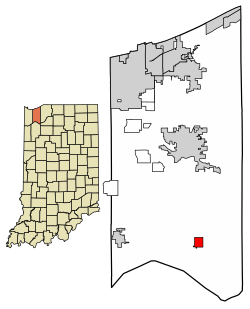
Porter County Indiana Incorporated and Unincorporated areas Kouts Highlighted 1840518.svg
Location of Kouts in Porter County, Indiana.
Coordinates: 41°19′02″N87°01′36″W / 41.31722°N 87.02667°W / 41.31722; -87.02667
Country United States
State Indiana
County Porter
Township Pleasant
Established1865
Government
  Typetown council
  presidentTim Jones
Area
[1]
  Total1.21 sq mi (3.14 km2)
  Land1.21 sq mi (3.14 km2)
  Water0.00 sq mi (0.00 km2)
Elevation
[2]
682 ft (208 m)
Population
 (2020)
  Total2,028
  Density1,671.89/sq mi (645.34/km2)
Time zone UTC-6 (CST)
  Summer (DST) UTC-5 (CDT)
ZIP code
46347
Area code 219
FIPS code 18-40518 [3]
GNIS feature ID2396697 [2]
Website www.koutsindiana.org

Kouts is a town in Pleasant Township, Porter County, in the U.S. state of Indiana. [2] The population was 2,028 at the 2020 census. [4] Since 2010, Kouts has had a population growth of 7.90 percent.

Contents

History

Main Street, 1910 Kouts, Indiana (1910).jpg
Main Street, 1910

Bernhardt Kautz moved here from Pennsylvania, before the arrival of the railroads, and established a farm where the town now sits. With the arrival of the Chicago and St. Louis Railway in 1865, Kautz and his brother-in-law H.A. Wright laid out the town and established a store. [5] Known as Kouts Station, the town grew slowly until the Chicago and Erie Railroad intersected the line in Kouts. Soon, Kouts became the social and economic center of the township. [6]

Railroads

Kouts would remain an important railroad town throughout the first half of the 20th century continuing to be served by the Erie Lackawanna Railway and the Pennsylvania Railroad. [7] Railroad traffic in the town began to decline following the bankruptcy of the Pennsylvania Railroad's successor, the Penn Central and the creation of Conrail. As the also bankrupt Erie Lackawanna would similarly be absorbed into the new company in 1976. The surplus of Conrail track through Kouts would lead to a decline in both traffic and profitability. The passage of the Staggers Rail Act of 1980 allowed for U.S railways to abandon unprofitable lines, which Conrail would take advantage of in Kouts. First with the Erie Lackawanna tracks in 1981 and then the Pennsylvania tracks in 1984. [8] [9] Currently there are little remnants of Kouts railroading past except for the former Pennsylvania Railroad depot which has been converted into a private business.

Geography

According to the 2010 census, Kouts has a total area of 1.12 square miles (2.90 km2), all land. [10]

Demographics

Historical population
CensusPop.Note
1880 214
1930 583
1940 73225.6%
1950 718−1.9%
1960 1,00740.3%
1970 1,38837.8%
1980 1,61916.6%
1990 1,603−1.0%
2000 1,6985.9%
2010 1,87910.7%
2020 2,0287.9%
Source: US Census Bureau

2000 census

As of the census [3] of 2000, there were 1,698 people, 678 households, and 499 families residing in the town. The population density was 1,522.0 inhabitants per square mile (587.6/km2). There were 720 housing units at an average density of 645.4/sq mi (248.2/km2). The racial makeup of the town was 99.00% White, 0.12% Asian, 0.65% from other races, and 0.24% from two or more races. Hispanic or Latino of any race were 1.24% of the population.

There were 678 households, out of which 34.1% had children under the age of 18 living with them, 60.5% were married couples living together, 9.9% had a female householder with no husband present, and 26.4% were non-families. 23.3% of all households were made up of individuals, and 9.6% had someone living alone who was 65 years of age or older. The average household size was 2.50 and the average family size was 2.94.

In the town the population was spread out, with 24.9% under the age of 18, 8.2% from 18 to 24, 31.2% from 25 to 44, 21.7% from 45 to 64, and 14.0% who were 65 years of age or older. The median age was 36 years. For every 100 females, there were 97.2 males. For every 100 females age 18 and over, there were 95.3 males.

The median income for a household in the town was $44,850, and the median income for a family was $50,819. Males had a median income of $42,315 versus $25,313 for females. The per capita income for the town was $19,239. About 1.7% of families and 3.2% of the population were below the poverty line, including 3.3% of those under age 18 and 3.4% of those age 65 or over.

2010 census

As of the census [11] of 2010, there were 1,879 people, 719 households, and 524 families residing in the town. The population density was 1,677.7 inhabitants per square mile (647.8/km2). There were 753 housing units at an average density of 672.3 per square mile (259.6/km2). The racial makeup of the town was 97.6% White, 0.3% African American, 0.3% Native American, 0.6% Asian, 0.2% from other races, and 1.0% from two or more races. Hispanic or Latino of any race were 5.1% of the population.

There were 719 households, of which 37.8% had children under the age of 18 living with them, 61.2% were married couples living together, 8.6% had a female householder with no husband present, 3.1% had a male householder with no wife present, and 27.1% were non-families. 22.9% of all households were made up of individuals, and 10.8% had someone living alone who was 65 years of age or older. The average household size was 2.61 and the average family size was 3.09.

The median age in the town was 35.5 years. 27.8% of residents were under the age of 18; 5.6% were between the ages of 18 and 24; 32.2% were from 25 to 44; 21% were from 45 to 64; and 13.6% were 65 years of age or older. The gender makeup of the town was 48.2% male and 51.8% female.

Education

Kouts is served by the East Porter County School Corporation. It has one school which is K-12. Kouts is also home to the East Porter County School Corporation's central administration office which oversees the operation of four other public schools in Porter County. Kouts schools spend an average of $4,027 per student. The average school expenditure in the U.S. is $5,678. There are about 18.7 students per teacher.

Kouts has a public library, a branch of the Porter County Public Library System. [12]

Infrastructure

Transportation

Related Research Articles

<span class="mw-page-title-main">Highland, Lake County, Indiana</span> Town in Indiana, United States

Highland is a town in Lake County, Indiana, United States. The population was 23,984 at the 2020 census. The town was incorporated on April 4, 1910. It is a part of the Chicago metropolitan area and North Township, and is surrounded by Hammond to the north, Munster to the west, Schererville to the south and Griffith to the east.

<span class="mw-page-title-main">Porter, Indiana</span> Town in Indiana, United States

Porter is a town in Westchester Township, Porter County, in the U.S. state of Indiana. The population was 4,858 at the 2010 census. Porter is in the Indiana Dunes ecosystem, which played a role in the creation of The Nature Conservancy, and inspired conservation efforts.

<span class="mw-page-title-main">Hamlet, Indiana</span> Town in Starke County, Indiana, United States

Hamlet is a town in Davis and Oregon Townships, Starke County, in the U.S. state of Indiana. The population was 800 as of the 2010 census.

<span class="mw-page-title-main">Riley, Indiana</span> Town in Indiana, United States

Riley, once known as Lockport, is a town in Riley Township, Vigo County, in the U.S. state of Indiana. The population was 221 at the 2010 census. It is part of the Terre Haute Metropolitan Statistical Area.

<span class="mw-page-title-main">Blasdell, New York</span> Village in New York, United States

Blasdell is a village in Erie County, New York, United States. The population was 2,553 according to the 2010 Census. The name is derived from Herman Blasdell, the first station master of the Erie and Pennsylvania railroad depot. It is part of the Buffalo–Niagara Falls Metropolitan Statistical Area.

<span class="mw-page-title-main">Sloan, New York</span> Village in New York, United States

Sloan is a village in Erie County, New York, United States. The population was 3,661 at the 2010 census. It is part of the Buffalo–Niagara Falls Metropolitan Statistical Area and is in the town of Cheektowaga.

Campbell is a town in Steuben County, New York, United States. The population was 3,163 at the 2020 census. The name is from Robert Campbell, an early landowner. The town is centrally located in the county and is northwest of Corning.

<span class="mw-page-title-main">Ludlow Falls, Ohio</span> Village in Ohio, United States

Ludlow Falls is a village in Miami County, Ohio, United States. The population was 175 at the 2020 census. It is part of the Dayton Metropolitan Statistical Area. Ludlow Falls is named after surveyor Israel Ludlow.

<span class="mw-page-title-main">La Plume Township, Lackawanna County, Pennsylvania</span> Place in Pennsylvania, United States

La Plume Township is a township in Lackawanna County, Pennsylvania, United States. The population was 486 at the 2020 census. It is home to Keystone College. La Plume is located 11 miles northwest of Scranton, one of Pennsylvania's most populated cities.

<span class="mw-page-title-main">Susquehanna Depot, Pennsylvania</span> Borough in Pennsylvania, United States

Susquehanna Depot, often referred to simply as Susquehanna, is a borough in Susquehanna County, Pennsylvania, United States, located on the Susquehanna River 23 miles (37 km) southeast of Binghamton, New York. In the past, railroad locomotives and railroad cars were made here. It is also known for its Pennsylvania Bluestone quarries.

<span class="mw-page-title-main">Nicholson, Pennsylvania</span> Borough in Pennsylvania, United States

Nicholson is a borough in Wyoming County, Pennsylvania. The population was 698 at the 2020 census.

<span class="mw-page-title-main">Greene (village), New York</span> Village in New York, United States

Greene is a village in Chenango County, New York, United States. The population was 1,580 at the 2010 census. The village is named after General Nathanael Greene. It is within the town of Greene and is northeast of Binghamton.

<span class="mw-page-title-main">Hancock (village), New York</span> Village in New York, United States

Hancock is a village in Delaware County, New York, United States. The population was 908 at the 2020 census. The village is in the west part of the town of Hancock at the junction of NY Routes 17 and 97.

Mount Morris is a village in the town of Mount Morris in Livingston County, New York, United States. The village population was 2,986 at the 2010 census, out of 4,465 in the entire town. The village and town are named after Robert Morris.

<span class="mw-page-title-main">Addison (village), New York</span> Village in New York, United States

Addison is a village in Steuben County, New York, United States, in the southeast part of the town of the same name, and southwest of the city of Corning. The population was 1,763 at the 2010 census. The village and the surrounding town are named after the author Joseph Addison.

<span class="mw-page-title-main">Addison, New York</span> Town in New York, United States

Addison is a town in Steuben County, New York. The population was 2,397 at the 2020 census. The name was selected to honor the author Joseph Addison. An interior town in the southeastern part of the county, the town includes a village, also called Addison.

<span class="mw-page-title-main">Avoca, New York</span> Town in New York, United States

Avoca is a town in Steuben County, New York, United States. The population was 1,996 at the 2020 census.

<span class="mw-page-title-main">Bath (village), New York</span> Village in New York, United States

Bath is a village in Steuben County, New York, United States. The population was 5,786 at the 2010 census. Bath is the county seat of Steuben County. The village is located in the town of the same name, northwest of Elmira and west of Tyrone.

Wayland is a village in Steuben County, New York, United States. The population was 1,865 at the 2010 census.

Wayland is a town in Steuben County, New York, United States. The population was 3,733 at the 2020 census.

References

  1. "2020 U.S. Gazetteer Files". United States Census Bureau. Retrieved March 16, 2022.
  2. 1 2 3 U.S. Geological Survey Geographic Names Information System: Kouts, Indiana
  3. 1 2 "U.S. Census website". United States Census Bureau . Retrieved January 31, 2008.
  4. "Geographic Identifiers: 2010 Demographic Profile Data (DP-1): Kouts town, Indiana". U.S. Census Bureau, American Factfinder. Archived from the original on February 12, 2020. Retrieved March 22, 2013.
  5. Kouts Centennial;, 1865-1965; Centennial Committee; Kouts, Indiana; Sept 2–6, 1965
  6. Porter County, Interim Report, Indiana Historic Sites and Structures Inventory; Indiana Dept of Natural Resources and Historic Landmarks Foundation of Indiana; July 1991, page 87
  7. "Porter County, Indiana, GenWeb - Photographs & Historical Images".
  8. "Elgin, OH to Hammond, IN - Abandoned Rails".
  9. "INDIANA RAILROADS (ABANDONED)" (PDF). IN.gov. Retrieved September 22, 2022.
  10. "G001 - Geographic Identifiers - 2010 Census Summary File 1". United States Census Bureau. Archived from the original on February 13, 2020. Retrieved July 17, 2015.
  11. "U.S. Census website". United States Census Bureau . Retrieved December 11, 2012.
  12. "Locations". Porter County Public Library System. Retrieved March 14, 2018.