Baillytown, Indiana

Last updated
Baillytown
Former community
Bailly, Indiana plan 1833.png
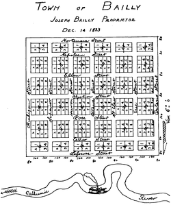
The planned layout of Bailly, Indiana, as recorded in 1833 by founder Joseph Bailly
USA Indiana location map.svg
Red pog.svg
Baillytown
Location within Indiana
Usa edcp location map.svg
Red pog.svg
Baillytown
Location within the United States
Coordinates: 41°37′48″N87°06′29″W / 41.63°N 87.108°W / 41.63; -87.108 Coordinates: 41°37′48″N87°06′29″W / 41.63°N 87.108°W / 41.63; -87.108
CountryFlag of the United States.svg  United States
StateFlag of Indiana.svg  Indiana
County Porter
Founded1833
Changed1876
LocationU.S. 12 west of Steel Mill and Power Plant entrance
Nearest City Porter, Indiana


Baillytown is a former community in northern Porter County, Indiana, near the present-day communities of Porter and Burns Harbor. Although the town platted as the Town of Bailly was never built, the Baillytown name was used for many years to refer to the area around the original Joseph Bailly trading post. The name continues today as the name of a subdivision, constructed in the 1990s, in the town of Porter. [1]

Contents

Baillytown began as a paper community, platted by Joseph Bailly in 1833 near his trading post on the Little Calumet River. Bailly had a group of French Canadians planning on settling in the dunes. When he became ill in 1835, he wrote to these families and recommended that they not journey to the shores of Lake Michigan. The development of a new settlement in the wilderness would be compounded by their lack of English and their lack of experience living among Indians. [2] In the 1830s, the Baillytown name was commonly used for the settlement around the Bailly trading post, which saw frequent visits from Potawatomi trading parties. Baillytown was on a northern branch of the Sauk Trail, [3] and was also accessible from Lake Michigan via Petit Fort. [4] When stagecoach traffic began in 1833, Baillytown was the last stop before Chicago, a journey that could take between six hours and six days depending on conditions. [5] Subsequently, the Long Pole Bridge, a terrifying thousand-foot wooden bridge, was constructed just west of Baillytown to allow travelers to cross the Little Calumet inland. [6]

Swedish-American community

In the 1850s, Baillytown became home to a growing Swedish-American community. It was originally populated by lumber workers who came to work in the sawmill operated by Bailly's son-in-law, and who later settled on farms in the area. [7] An 1856 account reported about 20 Swedish families in the area, engaged in farming and logging. [8] The immigrants were chiefly from Östergötland. [8]

Religious life in the town began with a visit by pioneer Swedish Lutheran minister Erland Carlsson around 1855. [8] Carlsson reported "a good deal of apathy" toward religion in the community, [8] but the Swedish Lutheran Church of Baillytown was organized in 1858 under the Augustana Synod. [9] The church continues today as the Augsburg Evangelical Lutheran Church in Porter. [8]

The town's residents wanted to ensure that their children did not lose touch with Swedish language and culture. [8] Consequently, a renovated toolshed, which had served as the town school from 1880 to 1885, was used until 1912 for Swedish language classes. [8] A substantial Swedish community also developed in the nearby town of Chesterton, centered on the Hillstrom Organ factory. [10] During this period, it is estimated that Westchester Township had the highest concentration of Swedes in Indiana. [10]

Legacy and present state

In the early 20th century, the Baillytown name was used for a local school, and for a stop on the South Shore Line. [11] One of eight one-room schools in Westchester Township, the Baillytown school was closed in the 1920s as part of the general consolidation of schools. [12] Later, early meetings of the Save the Dunes Council were held in the Baillytown schoolhouse. [13]

Today, the French Canadian and Swedish legacies of Baillytown are commemorated by the Chellberg Farm area of the Indiana Dunes National Lakeshore. [10] It takes its name from the Chellberg (originally Kjellberg) family, who developed a farm on part of the old Bailly property in the 1870s. [10]

See also

Works cited

Related Research Articles

Porter County, Indiana County in Indiana, United States

Porter County is a county in the U.S. state of Indiana. As of 2020, the population was 173,215, making it the 10th most populous county in Indiana. The county seat is Valparaiso. The county is part of Northwest Indiana, as well as the Chicago metropolitan area. Porter County is the site of much of the Indiana Dunes, an area of ecological significance. The Hour Glass Museum in Ogden Dunes documents the region's ecological significance.

Lake County, Indiana County in Indiana, United States

Lake County is a county located in the U.S. state of Indiana. In 2020, its population was 498,700, making it Indiana's second-most populous county. The county seat is Crown Point. The county is part of Northwest Indiana and the Chicago metropolitan area, and contains a mix of urban, suburban and rural areas. It is bordered on the north by Lake Michigan and contains a portion of the Indiana Dunes. It includes Marktown, Clayton Mark's planned worker community in East Chicago.

Chesterton, Indiana Town in Indiana, United States

Chesterton is a town in Westchester, Jackson and Liberty townships in Porter County, in the U.S. state of Indiana. The population was 14,241 at the 2020 Census. The three towns of Chesterton, Burns Harbor, and Porter are known as the Duneland area.

Porter, Indiana Town in Indiana, United States

Porter is a town in Westchester Township, Porter County, in the U.S. state of Indiana. The population was 4,858 at the 2010 census. Porter is in the Indiana Dunes ecosystem, which played a role in the creation of The Nature Conservancy, and inspired conservation efforts.

Indiana Dunes National Park United States National Park in Indiana

Indiana Dunes National Park is a United States national park located in northwestern Indiana managed by the National Park Service. It was authorized by Congress in 1966 as the Indiana Dunes National Lakeshore and was redesignated as the nation's 61st national park on February 15, 2019. The park runs for about 20 miles (32 km) along the southern shore of Lake Michigan and covers 15,349 acres (6,212 ha). Along the lakefront, the eastern area is roughly the lake shore south to U.S. 12 or U.S. 20 between Michigan City, Indiana, on the east and the ArcelorMittal steel plant on the west. A small extension south of the steel mill continues west along Salt Creek to Indiana 249. The western area is roughly the shoreline south to U.S. 12 between the Burns Ditch west to Broadway in downtown Gary, Indiana. In addition, there are several outlying areas, including Pinhook Bog, in LaPorte County to the east; the Heron Rookery in Porter County, the center of the park; and the Calumet Prairie State Nature Preserve and the Hobart Prairie Grove, both in Lake County, the western end of the park.

Joseph Bailly was a fur trader and a member of an important French Canadian family that included his uncle, Charles-François Bailly de Messein.

Westchester Township, Porter County, Indiana Township in Indiana, United States

Westchester Township is one of twelve townships in Porter County, Indiana. It is included in the Calumet, Northwest Indiana, and Great Lakes regions. It is located on the southern shore of Lake Michigan, about 50 miles (80 km) southeast of Chicago. It stretches from the famous Indiana Dunes on its northern border, south to the Valparaiso Moraine, a ridge of rolling hills left by the last glacier to pass through the area. As of the 2010 census, its population was 19,396.

Dune Park station

Dune Park is a station in Westchester Township, Porter County, Indiana, located north of the municipalities of Chesterton and Porter. It is used by South Shore Line trains, and serves as the headquarters of the Northern Indiana Commuter Transportation District (NICTD), the umbrella agency that operates the South Shore Line. It is located at the intersection of U.S. Highway 12 and Indiana State Road 49.

Miller Beach Neighborhood in Lake County, Indiana, United States

Miller Beach is a neighborhood of Gary, Indiana on the southernmost shore of Lake Michigan. First settled in 1851, Miller Beach was originally an independent town. However, the "Town of Miller" was eventually annexed by the then flourishing city of Gary in 1918. Located in the northeastern corner of Lake County, Indiana, the former town is now known as "The Miller Beach Community." Miller Beach borders Lake Michigan to the north, Porter County to the east, and is largely surrounded by protected lands, including Indiana Dunes National Park. Miller Beach is also the closest beach/resort community to Chicago, and has been a popular vacation spot since the early 20th century. As of the 2000 US census, it had a population of 9,900.

Chellberg Farm

Chellberg Farm is a historic farmstead which in 1972 became part of Indiana Dunes National Park. Chellberg Farm is significant as it represents the ethnic heritage of a nearly forgotten Swedish-American settlement. The farm includes a family home, water house with windmill, chicken coop/bunkhouse, and the original barn. Other nearby Swedish landmarks have been restored or preserved, including the Burstrom Chapel and the Burstrom Cemetery.

Tremont, Indiana Ghost town in Indiana, United States

Tremont, Indiana, is a ghost town formerly located in what is now the Indiana Dunes State Park and Indiana Dunes National Park in Westchester Township in northern Porter County, Indiana. It was first established in 1833. It was located at the intersection of U.S. Highway 12 and County Road 100 East, near Indiana 49. The community is named for three massive sand dunes that are now contained within the State park. They are Mount Tom, Mount Holden 170 feet (52 m), and Mount Green 160 feet (49 m).

The Swedish American Farmsteads of Porter County, Indiana are representative of the numerous rural communities settled by a significant ethnic population. They influenced the religious community and social community. This collection is the most complete early 20th century complex within the Swedish cultural landscape of Baileytown and has retained a great deal of integrity.

The lost towns are a group of places that are still commonly used by county residents. Each was at one time a post office, a store that served a part of the county, a grain elevator used by farmers to ship their crops, or a development that was or may still remain a unique designation. There may be a residential association or some other legal body devoted to the area. More often, these communities are communities of people who still refer to their homes by these geographic designations.

Habitats of the Indiana Dunes Set of habitats in the United States

The Indiana Dunes comprise ten different habitats. Each provides for a unique combination of plants and animals. The range of the Indiana Dunes varies depending your source. The Indiana Lake Michigan Coastal Program uses the river drainage systems along the shoreline. This expands the area from the areas of lakeshore southward to the edges of the Valparaiso Moraine. This entire region has been dune landscapes since over 114,000 years before present (YBP). Traditionally, the Indiana Dunes area thought of as a narrow area along the shores of Lake Michigan, including the areas of Marquette Park in Gary, Indiana (1920), Indiana Dunes State Park (1926) and Indiana Dunes National Park,. The identified ten habitats can be found in these parks, where they have been preserved, but are also visible throughout the three counties of Northwest Indiana.

East Arm Little Calumet River River in Indiana, United States

The East Arm Little Calumet River, also known as the Little Calumet River East Branch, is a 22.1-mile-long (35.6 km) portion of the Little Calumet River that begins just east of Holmesville, Indiana in New Durham Township in LaPorte County and flows west to Porter County and the Port of Indiana-Burns Waterway.

Tolleston Neighborhood in Lake County, Indiana, United States

Tolleston is a neighborhood and former town in west-central Gary, Indiana. It is situated south of Ambridge, west of Midtown, east of Westside and north of Black Oak. Tolleston is the site of two large city parks, a historic cemetery, and the oldest church north of the Little Calumet River. The neighborhood's borders are defined by the Norfolk Southern tracks on the north, Grant Street on the east, 25th Avenue on the south, and Clark Road on the west. As of 2000, Tolleston had a population of 14,289, and was 97.5% African-American.

Glen Park (Gary) Neighborhood in Lake County, Indiana, United States

Glen Park, also sometimes called University Park, is the most populous neighborhood in Gary, Indiana. It is situated on the city's far south side, south of the Little Calumet River and Borman Expressway. The neighborhood is often divided into Glen Park East and Glen Park West, on the respective sides of Broadway. Within Gary, Glen Park borders on Black Oak to the west and Midtown and Pulaski to the north; beyond Gary, it adjoins Hobart, Merrillville, and unincorporated Calumet Township. As of 2000, the neighborhood had a population of 25,454, approximately a third of Gary's total population. In terms of race, as of 2000 Glen Park was 86% African-American, 9% white, and 5.5% Hispanic.

City West, Indiana

City West was a village in Porter County, Indiana, USA, located on the shore of Lake Michigan approximately 10 miles west of Michigan City, Indiana. It was situated near the mouth of Fort Creek, now known as Dunes Creek, which empties into Lake Michigan near the Indiana Dunes State Park swimming beach. It was located near the former site of Petit Fort.

Indiana City was a notional community in northern Lake County, Indiana, at the mouth of the Grand Calumet River. It was located in present-day Marquette Park in Miller Beach, near the southern tip of Lake Michigan. Indiana City was one of a handful of early contenders to be a port city on southern Lake Michigan, alongside Chicago, City West, and Michigan City.

References

  1. "Baillytown Gets Thumbs Up". Post-Tribune. 1992-06-26. Archived from the original on 2014-06-11.
  2. Administrative History of Indiana Dunes National Lakeshore, National Park Service, Midwest Region; Omaha, Nebraska; 1989
  3. Schoon 2003, p. 50.
  4. Ball 1900, p. 315.
  5. Schoon 2003, p. 64.
  6. Schoon 2003, p. 66.
  7. McMahon 1997, p. 27.
  8. 1 2 3 4 5 6 7 Winquist 1996, p. 481.
  9. McMahon 1997, p. 32.
  10. 1 2 3 4 Winquist 1996, p. 482.
  11. Cynthia L. Ogorek (2012). Along the Chicago, South Shore and South Bend Rail Line. p. 56. ISBN   9780738594194.
  12. Westchester Public Library (1999). Westchester Township. p. 103. ISBN   9780738590318.
  13. Larry Waldron (1983). The Indiana Dunes. p. 34. ISBN   9780915992249.