Hurlburt, Indiana

Last updated

Hurlburt, Indiana
Hurlburt, Indiana (1910).jpg
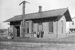
Railway station in Hurlburt (1910)
USA Indiana location map.svg
Red pog.svg
Hurlburt
Usa edcp location map.svg
Red pog.svg
Hurlburt
Coordinates: 41°22′12″N87°10′36″W / 41.37000°N 87.17667°W / 41.37000; -87.17667
Country United States
State Indiana
County Porter
Township Porter
Elevation
[1]
722 ft (220 m)
Time zone UTC-6 (Central (CST))
  Summer (DST) UTC-5 (CDT)
ZIP code
46341
Area code 219
GNIS feature ID436641 [1]

Hurlburt is an unincorporated community in Porter Township, Porter County, in the U.S. state of Indiana. [1] [2]

History

A post office was established at Hurlburt in 1883, and remained in operation until 1918. [3] The community was named for a pioneer settler. [4]

References

  1. 1 2 3 U.S. Geological Survey Geographic Names Information System: Hurlburt, Indiana
  2. "Vidette-Messenger of Porter County 26 Mar 1991, page 79".
  3. "Porter County". Jim Forte Postal History. Retrieved October 19, 2015.
  4. History of Porter County, Indiana : a narrative account of its historical progress, its people and its principal interests. Lewis Publishing Company. 1912. p. 172.