
Porter County is a county in the U.S. state of Indiana. As of 2020, the population was 173,215, making it the 10th most populous county in Indiana. The county seat is Valparaiso. The county is part of Northwest Indiana, as well as the Chicago metropolitan area. Porter County is the site of much of the Indiana Dunes, an area of ecological significance. The Hour Glass Museum in Ogden Dunes documents the region's ecological significance.

East Chicago is a city in Lake County, Indiana, United States. The population was 26,370 at the 2020 census. Centered around heavy industry, the city is home to the Indiana Harbor and Ship Canal, an artificial freshwater harbor characterized by industrial and manufacturing activity.

Burns Harbor is a town in Westchester Township, Porter County, Indiana, United States on the shores of Lake Michigan in Northwest Indiana. It is part of the Chicago metropolitan area. The population was 1,156 at the 2010 census. Burns Harbor is located adjacent to the Indiana Dunes, an area that conservationists have fought hard to preserve.

Dune Acres is a town in Westchester Township, Porter County, in the U.S. state of Indiana. The population was 182 at the 2010 census. Dune Acres is located in the duneland of the south shore of Lake Michigan. Many residents of Dune Acres and surrounding communities helped preserve parts of the Indiana Dunes.

Ogden Dunes is a town in Portage Township, Porter County, in the U.S. state of Indiana. It is located on the shore of Lake Michigan, within Indiana Dunes National Park and nearly surrounded by the city of Portage. The population was 1,110 at the 2010 census. It is named for multi-millionaire Francis A. Ogden, who owned the land there before his death in 1914. His main interest in the land where the dunes are was the sand which could be scooped up and sold, with more sand being replenished naturally over time.

The Calumet River is a system of heavily industrialized rivers and canals in the region between the south side of Chicago, Illinois, and the city of Gary, Indiana. Historically, the Little Calumet River and the Grand Calumet River were one, the former flowing west from Indiana into Illinois, then turning back east to its mouth at Lake Michigan at Marquette Park in Gary. Now the system is part of the Chicago Area Waterway System and through the use of locks flows away from Lake Michigan to the Cal-Sag Channel.

The Indiana Harbor and Ship Canal is an artificial waterway on the southwest shore of Lake Michigan, in East Chicago, Indiana, which connects the Grand Calumet River to Lake Michigan. It consists of two branch canals, the 1.25 miles (2.01 km) Lake George Branch and the 2 miles (3.2 km) long Grand Calumet River Branch which join to form the main Indiana Harbor Canal.

Indiana Dunes State Park is an Indiana State Park located in Porter County, Indiana, United States, 47 miles (75.6 km) east of Chicago. The park is bounded by Lake Michigan to the northwest and is surrounded by as well as within the authorized boundaries of Indiana Dunes National Park, a unit of the National Park Service; the NPS owns the water from the ordinary high water mark to 300 feet (91 m) offshore. The 1,530-acre (619.2 ha) Dunes Nature Preserve makes up the bulk of eastern part of the park, and includes most of the park's hiking trails and dune landscape. This was one of the first places Richard Lieber considered when establishing the Indiana State Park system. Like all Indiana state parks, there is a fee for entrance. Indiana Dunes State Park was established in 1925 and designated a National Natural Landmark in 1974.
Northwest Indiana, nicknamed The Region after the Calumet Region, comprises Lake, Porter, LaPorte, and Newton counties in Indiana. This region neighbors Lake Michigan and is part of the Chicago metropolitan area. According to the 2020 Census, Northwest Indiana has a population of 831,080 and is the state's second largest urban area after the Indianapolis Metropolitan Area. It is also the home of the Indiana Dunes, parts of which have been preserved through conservation efforts. The town of Ogden Dunes houses the Hour Glass, a museum showcasing the ecological and conservation efforts of O. D. Frank.

U.S. Route 12 (US 12) is a part of the United States Numbered Highway System that runs from Aberdeen, Washington, to Detroit, Michigan. In the U.S. state of Indiana, it is part of the state road system. US 12 enters the state concurrent with US 20 and US 41 in Whiting. The 46.258 miles (74.445 km) of US 12 that lie within Indiana serve as a major conduit. Some of the highway is listed on the National Highway System (NHS). Various sections are rural two-lane highway, urbanized four-lane undivided highway, and one-way streets. The easternmost community along the highway is Michiana Shores at the Michigan state line.

Cowles Bog is a 4,000-year-old wetland complex in Indiana Dunes National Park, near Chesterton, Indiana. It is named for Henry Chandler Cowles who did his pioneering work in ecology and ecological succession here. His work brought international attention to the area which led to efforts to preserve the Indiana Dunes. It was designated a National Natural Landmark in 1965. It contains bog, fen, marsh, wet meadow, swamp, and pond habitats.

Portage Township is one of twelve townships in Porter County, Indiana. As of the 2010 census, its population was 47,085. Portage Township was established in 1835.
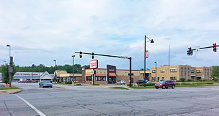
Portage is a city in Portage Township, Porter County, in the U.S. state of Indiana, on the border with Lake County. The population was 37,926 as of the 2020 census. It is the largest city in Porter County, and third largest in Northwest Indiana.
The Indiana dunes have been a cross road of activity since the glacier receded. Great explorers such as Jacques Marquette and René-Robert Cavelier, Sieur de La Salle traversed this area. As early as 1862, the area was noted for its unique natural resources. At the start of the 20th century, the dunes were a living laboratory for scientist studying plants, animals, and the changes in the land. The first ecologist did his pioneering work here.
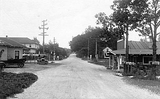
Tremont, Indiana, is a ghost town formerly located in what is now the Indiana Dunes State Park and Indiana Dunes National Park in Westchester Township in northern Porter County, Indiana. It was first established in 1833. It was located at the intersection of U.S. Highway 12 and County Road 100 East, near Indiana 49. The community is named for three massive sand dunes that are now contained within the State park. They are Mount Tom, Mount Holden 170 feet (52 m), and Mount Green 160 feet (49 m).
The Indiana Dunes are natural sand dunes occurring at the southern end of Lake Michigan in the American State of Indiana. They are known for their ecological significance. Many conservationists have played a role in preserving parts of the Indiana Dunes. The Hour Glass, a museum in Ogden Dunes, showcases some of the ecological import of the Dunes.

The Indiana Dunes comprise ten different habitats. Each provides for a unique combination of plants and animals. The range of the Indiana Dunes varies depending your source. The Indiana Lake Michigan Coastal Program uses the river drainage systems along the shoreline. This expands the area from the areas of lakeshore southward to the edges of the Valparaiso Moraine. This entire region has been dune landscapes since over 114,000 years before present (YBP). Traditionally, the Indiana Dunes area thought of as a narrow area along the shores of Lake Michigan, including the areas of Marquette Park in Gary, Indiana (1920), Indiana Dunes State Park (1926) and Indiana Dunes National Park,. The identified ten habitats can be found in these parks, where they have been preserved, but are also visible throughout the three counties of Northwest Indiana.
Long Lake is a large interdunal wetland in the Indiana Dunes region of Northwest Indiana. It was originally approximately 8 miles in length, but has been shortened due to development and drainage. It has a surface area of 34 hectares, and a maximum depth of 1.8 meters. There are three small islands, and the total shoreline length is 4.6 kilometers.

An interdunal wetland, interdunal pond or dune slack is a water-filled depression between coastal sand dunes. It may be formed either by wind erosion or by dunal encroachment on an existing wetland. The wind erosion process involves wind scooping out sufficient sand to reach the water table, and typically occurs behind the first line of foredunes.
Dorothy Richardson Buell (1886–1976) was an American educator and nature preservationist who became the founder and first president of the Save the Dunes Council, a nonprofit group dedicated to preserving the Indiana dunelands along Lake Michigan. Buell led a grassroots effort to save the remaining unspoiled dunes in northwestern Indiana from industrial development. Buell's sixteen-year leadership of the Save the Dunes Council, from 1952 to 1968, preserved thousands of acres of dunelands at the Indiana Dunes National Lakeshore, which she helped to establish in 1966 as an urban park as part of the National Park Service.

