Shoals, Indiana | |
---|---|
Coordinates: 38°40′01″N86°47′38″W / 38.66694°N 86.79389°W | |
Country | United States |
State | Indiana |
County | Martin |
Townships | Center, Halbert |
Area | |
• Total | 1.92 sq mi (4.97 km2) |
• Land | 1.82 sq mi (4.72 km2) |
• Water | 0.10 sq mi (0.25 km2) |
Elevation | 453 ft (138 m) |
Population | |
• Total | 677 |
• Density | 371.16/sq mi (143.32/km2) |
Time zone | UTC-5 (Eastern (EST)) |
• Summer (DST) | UTC-4 (EDT) |
ZIP code | 47581 |
Area code(s) | 812, 930 |
FIPS code | 18-69552 [4] |
GNIS feature ID | 2397661 [2] |
Website | townofshoals |
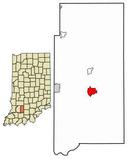
Shoals is a town in Center and Halbert townships and the county seat of Martin County, [5] in the U.S. state of Indiana. [6] The population was 677 at the 2020 census. [3]
Shoals is best known for the Jug Rock, the only free-standing table rock formation east of the Mississippi River. [7]
Shoals was originally called "Memphis", and under the latter name was platted in 1844. [8] The post office at Shoals has been in operation since 1869. [9]
A lynching took place at the county courthouse and jail. The Archer boys were accused of torturing and killing a local farmer and were hanged from trees in front of the jail in 1886. [10]
Shoals is known for making mother of pearl buttons during the early 20th century. They were made out of mussels from the White River. [10]
Shoals is located south of the center of Martin County. The East Fork of the White River flows through the center of town, running south and west to join the White River northeast of Petersburg.
U.S. Routes 50 and 150 pass through the center of Shoals as 4th Street, leading west 7 miles (11 km) to Loogootee, the only city in the county. US 50 leads northeast 24 miles (39 km) to Bedford, while US 150 leads southeast 22 miles (35 km) to Paoli.
According to the U.S. Census Bureau, Shoals has a total area of 1.92 square miles (4.97 km2), of which 1.82 square miles (4.71 km2) are land and 0.10 square miles (0.26 km2), or 4.95%, are water. [1]
The climate in this area is characterized by hot, humid summers and generally mild to cool winters. According to the Köppen Climate Classification system, Shoals has a humid subtropical climate, abbreviated "Cfa" on climate maps. [11]
Census | Pop. | Note | %± |
---|---|---|---|
1870 | 513 | — | |
1880 | 706 | 37.6% | |
1890 | 738 | 4.5% | |
1900 | 683 | −7.5% | |
1910 | 1,015 | 48.6% | |
1920 | 1,034 | 1.9% | |
1930 | 1,128 | 9.1% | |
1940 | 1,031 | −8.6% | |
1950 | 1,039 | 0.8% | |
1960 | 1,022 | −1.6% | |
1970 | 1,039 | 1.7% | |
1980 | 967 | −6.9% | |
1990 | 853 | −11.8% | |
2000 | 807 | −5.4% | |
2010 | 756 | −6.3% | |
2020 | 677 | −10.4% | |
U.S. Decennial Census [12] |
As of the census [13] of 2010, there were 756 people, 376 households, and 189 families living in the town. The population density was 422.3 inhabitants per square mile (163.1/km2). There were 418 housing units at an average density of 233.5 per square mile (90.2/km2). The racial makeup of the town was 97.4% White, 0.3% African American, 0.1% Native American, 0.3% Asian, 0.4% from other races, and 1.6% from two or more races. Hispanic or Latino of any race were 1.3% of the population.
There were 376 households, of which 23.7% had children under the age of 18 living with them, 32.7% were married couples living together, 13.0% had a female householder with no husband present, 4.5% had a male householder with no wife present, and 49.7% were non-families. 46.0% of all households were made up of individuals, and 22.4% had someone living alone who was 65 years of age or older. The average household size was 2.01 and the average family size was 2.81.
The median age in the town was 47.1 years. 20.1% of residents were under the age of 18; 7% were between the ages of 18 and 24; 20.8% were from 25 to 44; 27.3% were from 45 to 64; and 24.6% were 65 years of age or older. The gender makeup of the town was 49.1% male and 50.9% female.
As of the census [4] of 2000, there were 807 people, 377 households, and 214 families living in the town. The population density was 448.0 inhabitants per square mile (173.0/km2). There were 420 housing units at an average density of 233.1 per square mile (90.0/km2). The racial makeup of the town was 97.52% White, 0.87% African American, 0.25% Native American, 0.12% from other races, and 1.24% from two or more races. Hispanic or Latino of any race were 1.49% of the population.
There were 377 households, out of which 19.1% had children under the age of 18 living with them, 41.1% were married couples living together, 12.5% had a female householder with no husband present, and 43.0% were non-families. 38.5% of all households were made up of individuals, and 20.2% had someone living alone who was 65 years of age or older. The average household size was 2.01 and the average family size was 2.65.
In the town, the population was spread out, with 17.0% under the age of 18, 8.9% from 18 to 24, 24.9% from 25 to 44, 26.3% from 45 to 64, and 22.9% who were 65 years of age or older. The median age was 44 years. For every 100 females, there were 100.7 males. For every 100 females age 18 and over, there were 98.8 males.
The median income for a household in the town was $23,750, and the median income for a family was $31,964. Males had a median income of $30,865 versus $21,696 for females. The per capita income for the town was $14,234. About 14.6% of families and 20.4% of the population were below the poverty line, including 33.0% of those under age 18 and 8.1% of those age 65 or over.
Shoals' major employers are the gypsum mines that were discovered in the mid-20th century. Two major mines employ more than 400 workers. The National Gypsum mine is located 2 miles (3 km) east of Shoals and is the United States' deepest at 515 feet (157 m). [10]
The gypsum mine and factory in Shoals, Indiana, operated by National Gypsum. The mine, which started operations in the 1950s, is about 400-500 feet underground. It supplies gypsum for the production of drywall and other related products directly at the surface manufacturing plant. National Gypsum extracts around 80-100 truckloads of gypsum daily to produce materials like wallboard, and the facility employs around 190-200 people. This integration of mining and manufacturing is efficient, as the gypsum is mined, processed, and turned into drywall all in one location.
The town has a lending library, the Shoals Public Library. [14] Public education is administered by Shoals Public Schools.
Waterloo is a town in Lauderdale County, Alabama, United States. It is part of the Florence–Muscle Shoals metropolitan area, known as "The Shoals". As of the 2010 census, the population of the town was 203, down from 208 in 2000. The town and surrounding area is served by Waterloo High School and by the Waterloo Volunteer Fire Department.
The Town of Gypsum is the home rule municipality that is the most populous municipality in Eagle County, Colorado, United States. The town population was 8,040 at the 2020 United States Census, a +24.13% increase since the 2010 United States Census. Gypsum is a part of the Edwards, CO Micropolitan Statistical Area. Gypsum is the home of an American Gypsum drywall plant and mine.
Jonesville is a town in Wayne Township, Bartholomew County, in the U.S. state of Indiana. The population was 177 at the 2010 census. It is part of the Columbus, Indiana metropolitan statistical area.
Nashville is a town in Washington Township, Brown County, Indiana, United States. The population was 1,256 at the 2020 census. The town is the county seat of Brown County and is the county's only incorporated town. The town is best known as the center of the Brown County Art Colony and as a tourist destination.
Dillsboro is a town in Clay Township, Dearborn County, Indiana, United States. As of 2020, the population is 1,360.
Newberry is a town in Cass Township, Greene County, Indiana, United States. The population was 193 at the 2010 census. It is part of the Bloomington, Indiana Metropolitan Statistical Area.
Whiteland is a town in Pleasant, Franklin and Clark townships, Johnson County, Indiana, United States. The population was 4,599 at the 2020 census.
Wheatland is a town in Steen Township, Knox County, Indiana, United States. The population was 480 at the 2010 census.
Paoli is a town within Paoli Township and the county seat of Orange County, in the U.S. state of Indiana. The population was 3,677 at the 2010 census.
Spencer is a town in Washington Township, Owen County, in the U.S. state of Indiana. The population was 2,217 at the 2010 census. It is the county seat of Owen County.
Rockville is a town in Adams Township, Parke County, in the U.S. state of Indiana. The population was 2,607 at the 2010 census. The town is the county seat of Parke County. It is known as "The Covered Bridge Capital of the World".
Cannelton is a city in Troy Township, Perry County, in the U.S. state of Indiana, along the Ohio River. The population was 1,563 at the 2010 census. Cannelton, which was the smallest incorporated city in the state until 2010, was formerly the county seat of Perry County until the seat was relocated to Tell City.
Petersburg is a city within Washington Township and the county seat of Pike County, in the U.S. state of Indiana. The population was 2,304 at the 2020 census.
Winslow is a town in Patoka Township, Pike County, in the U.S. state of Indiana. The population was 764 at the 2020 census. It is part of the Jasper Micropolitan Statistical Area.
Poseyville is a town in Robb Township, Posey County, in the U.S. state of Indiana. The population was 1,045 at the 2010 census.
Sunman is a town in Adams Township, Ripley County, in the U.S. state of Indiana. The population was 1,049 at the 2010 census.
Scottsburg is a city within Vienna Township and the county seat of Scott County, in the U.S. state of Indiana, about 30 miles (48 km) north of Louisville, Kentucky. The population of Scottsburg was 7,345 at the 2020 census.
Fairview Park is a town in Clinton Township, Vermillion County, in the U.S. state of Indiana. The population was 1,386 at the 2010 census.
Seelyville is a town in Lost Creek Township, Vigo County, in the U.S. state of Indiana. The population was 1,029 at the 2010 census. It is part of the Terre Haute Metropolitan Statistical Area.
Chandler is a town straddling Ohio and Boon Township in Warrick County, Indiana, United States, located just east of Evansville, Indiana along the Ohio River. The population was 3,693 at the 2020 census, making it Warrick County's second-most populous municipality after Boonville. The town is part of the Evansville metropolitan area with a population of 342,815.