Templeton, Indiana

Last updated

Templeton, Indiana
Templeton goats.png
Animals along Ann Street.
Map of Indiana highlighting Benton County.svg
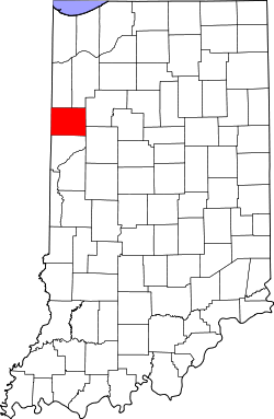
Benton County's location in Indiana
Location map for Benton County, Indiana.svg
Red pog.svg
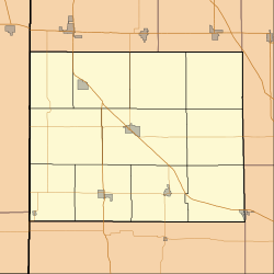
Templeton
Freeland Park's location in Benton County
Coordinates: 40°30′46″N87°12′27″W / 40.51278°N 87.20750°W / 40.51278; -87.20750
Country Flag of the United States (23px).png  United States
State Flag of Indiana.svg Indiana
County Benton
Township Bolivar
FoundedDecember 23, 1873
Named after The Templeton family
Area
[1]
  Total
0.12 sq mi (0.31 km2)
  Land0.12 sq mi (0.31 km2)
  Water0.00 sq mi (0.00 km2)
Elevation
[2]
702 ft (214 m)
Population
 (2020)
  Total
75
  Density635.59/sq mi (245.22/km2)
Time zone UTC-5 (Eastern (EST))
  Summer (DST) UTC-4 (EDT)
ZIP code
47986
Area code 765
GNIS feature ID 444630

Templeton is an unincorporated community in Bolivar Township, Benton County, in the U.S. state of Indiana. [3] It is part of the Lafayette, Indiana Metropolitan Statistical Area.

Contents

History

Templeton was laid out by Col. William J. Templeton and his wife Melissa on December 23, 1873, and contained 225 lots. Two railways, the Cleveland, Cincinnati, Chicago and St. Louis (the "Big Four") and the Lafayette, Muncie and Bloomington (the "Nickel Plate"), intersected at the site. Its first building was a shanty occupied by John Cosgrove, and was soon followed by the dwellings of Col. Templeton and others. The town gained it first grain elevator in 1874 and a tile factory in 1881 which operated two large, steam-powered kilns. By 1883 the town's businesses included David Lanham & Co. and Finch & Son (both purveyors of dry goods and groceries), Joseph Dehart's notions and butcher shop, John Rosa's grocery, Dr. C. W. Fall (physician and pharmacist), Jasper Bristow (physician) and the Railroad House. [4] Templeton's population numbered around 150 in the 1920s, at which time it also had a grain elevator, grade school and three or four stores. [5]

A post office was established at Templeton in 1873, and remained in operation until it was discontinued in 1931. [6]

Geography

Templeton is located at 40°30′46″N87°12′27″W / 40.51278°N 87.20750°W / 40.51278; -87.20750 in Bolivar Township. It is surrounded by open farmland, with Big Pine Creek less than a mile to the southeast. U.S. Route 52 passes along the town's northeast side, and the Kankakee, Beaverville and Southern Railroad, which comes in from the east, splits into two lines that head west and northwest.

Demographics

Historical population
CensusPop.Note
2020 75
U.S. Decennial Census [7]

Education

It is in the Benton Community School Corporation. [8] Its comprehensive high school is Benton Central Junior-Senior High School.

References

  1. "2020 U.S. Gazetteer Files". United States Census Bureau. Retrieved March 16, 2022.
  2. "US Board on Geographic Names". United States Geological Survey. October 25, 2007. Retrieved January 31, 2008.
  3. "Templeton, Indiana". Geographic Names Information System . United States Geological Survey . Retrieved February 29, 2020.
  4. Mossman, Ed (1883). "History of Benton County: Past Events -- Present Condition". Counties of Warren, Benton, Jasper and Newton, Indiana: Historical and Biographical. Chicago: F. A. Battey & Co.
  5. Birch, Jesse Setlington (1942) [1928]. "Unincorporated community s of the County". History of Benton County and Historic Oxford. Oxford, Indiana: Craw & Craw. pp. 200–201.
  6. "Benton County". Jim Forte Postal History. Retrieved February 29, 2020.
  7. "Census of Population and Housing". Census.gov. Retrieved June 4, 2016.
  8. Geography Division. 2020 CENSUS - SCHOOL DISTRICT REFERENCE MAP: Benton County, IN (PDF) (Map). U.S. Census Bureau . Retrieved June 7, 2025. - Text list