Dunnington, Indiana

Last updated

Dunnington, Indiana
Map of Indiana highlighting Benton County.svg
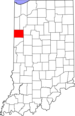
Benton County's location in Indiana
Location map for Benton County, Indiana.svg
Red pog.svg
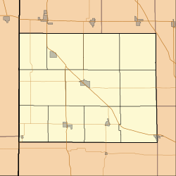
Dunnington
Dunnington's location in Benton County
Coordinates: 40°33′51″N87°29′27″W / 40.56417°N 87.49083°W / 40.56417; -87.49083
Country Flag of the United States (23px).png  United States
State Flag of Indiana.svg Indiana
County Benton
Township Parish Grove
Elevation
[1]
234 m (768 ft)
Time zone UTC-5 (Eastern (EST))
  Summer (DST) UTC-4 (EDT)
ZIP code
47944
Area code 765
FIPS code 18-19126 [2]
GNIS feature ID 433799

Dunnington is a small unincorporated community in Parish Grove Township, Benton County, in the U.S. state of Indiana. [3]

Contents

History

Benton County Railroad Map, circa 1896, showing the location of Dunnington Benton County Railroad Map, circa 1896.png
Benton County Railroad Map, circa 1896, showing the location of Dunnington

Named for Capt. James Dunn, [4] it stands about one and a half miles west of its smaller sister town, Dunn. A post office was established at Dunnington in 1888, and was discontinued in 1903. [5] In the early 20th century it supported a Catholic church and school, a general store, a Forresters lodge and about half a dozen residences [6] (an estimate similar to the town's current size). St. Mary's Catholic Church, established in the late 19th century, was renovated in the early 1950s and was home to St. Mary's Catholic School, which closed in the late 1960s.

Stained glass in St. Mary's Catholic Church Dunnington, Indiana stained glass.png
Stained glass in St. Mary's Catholic Church

Geography

Dunnington is located at 40°33′51″N87°29′27″W / 40.56417°N 87.49083°W / 40.56417; -87.49083 , on the border of Parish Grove Township and Hickory Grove Township, two miles east of the border with Illinois. Indiana State Road 71 passes north through the town, and a small creek named Kult Ditch flows northwest toward Mud Creek.

Notable people

References

  1. "US Board on Geographic Names". United States Geological Survey. October 25, 2007. Archived from the original on February 2, 2001. Retrieved January 31, 2008.
  2. "U.S. Census website". United States Census Bureau. Archived from the original on December 27, 1996. Retrieved January 31, 2008.
  3. "Dunnington, Indiana". Geographic Names Information System . United States Geological Survey. Archived from the original on November 7, 2023. Retrieved February 29, 2020.
  4. Baker, Ronald L. (October 1995). From Needmore to Prosperity: Hoosier Place Names in Folklore and History . Indiana University Press. p.  118. ISBN   978-0-253-32866-3. ...and named for Captain James Dunn, who founded nearby Dunnington.
  5. "Benton County". Jim Forte Postal History. Archived from the original on September 3, 2014. Retrieved August 26, 2014.
  6. Birch, Jesse Setlington (1942) [1928]. "Unincorporated community s of the County". History of Benton County and Historic Oxford. Oxford, Indiana: Craw & Craw. p. 201.