Murray, Indiana

Last updated

Murray, Indiana
Murray, Indiana signage.jpg
"Welcome to Murray, Indiana!"
Map of Indiana highlighting Wells County.svg
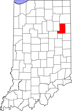
Wells County's location in Indiana
Location map of Wells County, Indiana.svg
Red pog.svg
Murray
Location of Murray in Wells County
Coordinates: 40°47′31″N85°12′03″W / 40.79194°N 85.20083°W / 40.79194; -85.20083
Country United States
State Indiana
County Wells
Township Lancaster
Elevation
[1]
807 ft (246 m)
Time zone UTC-5 (Eastern (EST))
  Summer (DST) UTC-4 (EDT)
ZIP code
46714
Area code 260
FIPS code 18-51966 [2]
GNIS feature ID439894 [1]

Murray is an unincorporated area near Lancaster Township, Wells County, in the U.S. state of Indiana. [1]

Contents

History

An old variant name of the community was called New Lancaster. [3] A post office was established at Murray in 1837, and remained in operation until 1902. [4]

On February 29, 1996, Murray was inadvertently strafed by a military aircraft, though no injuries resulted. [5]

In January 2020, a town-wide vote took place which led to Zakary J. Dobson being the mayor of Murray. The vote also proclaimed Evan C. Saunders as the Sheriff of Murray. Evan's wife, Shelby Saunders, is Deputy. [6]

Former Mayor's include: Brian Fennig and Jon Dobson. [7]

Geography

Murray is located on State Highway 116.

References

  1. 1 2 3 U.S. Geological Survey Geographic Names Information System: Murray, Indiana
  2. "U.S. Census website". United States Census Bureau . Retrieved January 31, 2008.
  3. "USGS detail on Murray - Variant Citation" . Retrieved May 10, 2017.
  4. "Wells County". Jim Forte Postal History. Retrieved July 7, 2016.
  5. The strafing of Murray
  6. Public records of the Town of Murray
  7. Public records of the Town of Murray