"},"elevation_ft":{"wt":"846"},"coordinates":{"wt":"{{coord|40|21|36|N|81|25|46|W|region:US_type:city|display=inline,title}}"},"postal_code_type":{"wt":"[[ZIP code]]"},"postal_code":{"wt":"44629"},"area_code":{"wt":"[[Area code 740|740]], [[Area code 330|330]]"},"blank_name":{"wt":"[[Federal Information Processing Standard|FIPS code]]"},"blank_info":{"wt":"39-30702{{cite web |url=https://www.census.gov |publisher=[[United States Census Bureau]] |access-date=January 31, 2008 |title=U.S. Census website }}"},"blank1_name":{"wt":"[[Geographic Names Information System|GNIS]] feature ID"},"blank1_info":{"wt":"2398983{{GNIS|2398983}}"},"website":{"wt":""},"footnotes":{"wt":""}},"i":0}}]}" id="mwBw">Village in Ohio, United States
Gnadenhutten, Ohio | |
---|---|
![]() Monument at the massacre site | |
![]() Location of Gnadenhutten, Ohio | |
![]() Location of Gnadenhutten in Tuscarawas County | |
Coordinates: 40°21′36″N81°25′46″W / 40.36000°N 81.42944°W | |
Country | United States |
State | Ohio |
County | Tuscarawas |
Townships | Clay, Warwick, & Rush |
Government | |
• Mayor | Timmothy ‘Moth’ McCormick [1] |
Area | |
• Total | 0.92 sq mi (2.37 km2) |
• Land | 0.92 sq mi (2.37 km2) |
• Water | 0.00 sq mi (0.00 km2) |
Elevation | 846 ft (258 m) |
Population (2020) | |
• Total | 1,240 |
• Estimate (2023) [4] | 1,209 |
• Density | 1,353.71/sq mi (522.82/km2) |
Time zone | UTC-5 (Eastern (EST)) |
• Summer (DST) | UTC-4 (EDT) |
ZIP code | 44629 |
Area code(s) | 740, 330 |
FIPS code | 39-30702 [5] |
GNIS feature ID | 2398983 [3] |
Gnadenhutten ( /dʒəˈneɪdənhʌtən/ jə-NAY-dən-hut-ən, [6] meaning "Huts of Grace" in German) is a village located on the Tuscarawas River in Tuscarawas County, Ohio, United States. The population was 1,240 at the 2020 census. It is Ohio's oldest existing settlement, being founded by Moravian Christians in 1772 and was the site of the Gnadenhutten massacre during the American Revolutionary War. [7] It is part of the New Philadelphia–Dover micropolitan area.
Gnadenhutten is derived from the German name Gnadenhütten (German: [ˈgnaːdn̩hʏtn̩] ), [8] meaning literally "huts of grace" or "mercy huts" and figuratively "log tabernacle". [9] Gnadenhutten was declared the "most difficult to pronounce" place name in the state of Ohio by Reader's Digest . [10]
Gnadenhutten, originally Gnadenhütten, was founded in October 1772 as the second settlement of German Americans and Lenape Indians affiliated with the Moravian Church. [11] Tribes of Christian Lenni Lenape people had settled at Schoenbrunn nearby, founded months earlier by missionary David Zeisberger. On July 4, 1773, a baby boy was born to the Roth family, becoming the first white child known to be born in the Ohio territory. [12] This community, originally led by the Christian Mohican chieftain Joshua (who died August 1 of the following year), had grown to about 200 persons by 1775.
As pacifists, they remained neutral during the American Revolution and subsequent Revolutionary War. However, the British and their Indian Wyandot and Delaware allies suspected that members of the Christian Gnadenhutten, Schoenbrunn, and Salem communities had provided aid to American patriots. As a result, the British forced the Lenape tribespeople in the region to the Upper Sandusky area of the Ohio territory. [11] While the British detained Rev. Zeisberger at Fort Detroit, they allowed roughly 150 Lenape to return to their old town to gather the harvest and supplies stored there. However, Pennsylvania militiamen, led by David Williamson, following the murder of American settlers by other Indian tribes a few weeks earlier, came to the resettled town in March 1782, and tricked the Indians into giving up their weapons. Ninety-six innocent Lenape men, women, and children spent the night in song and prayer knowing they would be slaughtered the following morning.
On March 8, 1782, the Pennsylvanians committed the Gnadenhutten massacre and burned the approximately 60 cabins in the town. Only two boys escaped; the incident led to distrust between Native Americans and American settlers, and reprisals against American patriots in Native American custody. [13] [14]
Although three 4,000 acre tracts were reserved for Indians as an "act of indemnity", [15] John Ettwein petitioned Congress in 1783 and the area was then opened to European American settlers. John Heckewelder from Pennsylvania built the first house in 1798, and Moravians remain in the town today. Few Native Americans chose to live there and they gave up title in 1823 after the Moravians had made many improvements.
Gnadenhutten was on a major wagon road crossing the Tuscarawas River. The first Ohio Canal was dug nearby in 1825-1830, providing access to markets as well as further immigrants via Cleveland. A railroad linked to the area in 1853, further improving market access and allowing industrial development. A flood in 1915 destroyed the canal, which was not rebuilt as other means of transportation had superseded it. [13]
Gnadenhutten erected a monument to the martyrs of the March 8, 1782, massacre during the centennial of its founding, and in 1963 established a museum interpreting it and other aspects of the town's history (including the results of 1970 excavations, and having rebuilt the Mission House and Cooper shop, and erected a mound containing the martyrs' graves). [13] Various Native American and First Nations people gathered at the site in 1988 to dedicate a peace tree. The State of Ohio erected a memorial marker in 2003, calling the event a "day of shame"; it had erected another historical marker shortly before the town's entrance in 1979. [16]
The Moravians rebuilt their church in 1903 and dedicated it as a memorial to John Heckewelder. The village also has a Masonic Temple (built 1855 and rebuilt), Methodist church (built circa 1910), as well as a Church of Christ and Full Gospel Pentecostal Church on the outskirts. [17] Its current library was erected in 1942.[ citation needed ]
According to the United States Census Bureau, the village has a total area of 0.97 square miles (2.51 km2), all land. [18]
Census | Pop. | Note | %± |
---|---|---|---|
1870 | 284 | — | |
1880 | 336 | 18.3% | |
1890 | 478 | 42.3% | |
1900 | 547 | 14.4% | |
1910 | 560 | 2.4% | |
1920 | 530 | −5.4% | |
1930 | 870 | 64.2% | |
1940 | 876 | 0.7% | |
1950 | 895 | 2.2% | |
1960 | 1,257 | 40.4% | |
1970 | 1,466 | 16.6% | |
1980 | 1,320 | −10.0% | |
1990 | 1,226 | −7.1% | |
2000 | 1,280 | 4.4% | |
2010 | 1,288 | 0.6% | |
2020 | 1,240 | −3.7% | |
2023 (est.) | 1,209 | [4] | −2.5% |
U.S. Decennial Census [19] |
As of the census [20] of 2010, there were 1,288 people, 509 households, and 359 families living in the village. The population density was 1,327.8 inhabitants per square mile (512.7/km2). There were 553 housing units at an average density of 570.1 per square mile (220.1/km2). The racial makeup of the village was 99.1% white, 0.2% from other races, and 0.7% from two or more races. Hispanic or Latino of any race were 0.5% of the population.
There were 509 households, of which 35.0% had children under the age of 18 living with them, 60.3% were married couples living together, 6.7% had a female householder with no husband present, 3.5% had a male householder with no wife present, and 29.5% were non-families. 25.7% of all households were made up of individuals, and 14.2% had someone living alone who was 65 years of age or older. The average household size was 2.52 and the average family size was 3.05.
The median age in the village was 39.3 years. 25.6% of residents were under the age of 18; 6.7% were between the ages of 18 and 24; 26.2% were from 25 to 44; 24.3% were from 45 to 64; and 17.4% were 65 years of age or older. The gender makeup of the village was 49.5% male and 50.5% female.
As of the census [5] of 2000, there were 1,280 people, 513 households, and 377 families living in the village. The population density was 1,281.7 inhabitants per square mile (494.9/km2). There were 539 housing units at an average density of 539.7 per square mile (208.4/km2). The racial makeup of the village was 99.45% white, 0.08% African American, and 0.47% from two or more races. Hispanic or Latino of any race were 0.16% of the population.
There were 513 households, out of which 30.4% had children under the age of 18 living with them, 62.8% were married couples living together, 7.6% had a female householder with no husband present, and 26.5% were non-families. 24.2% of all households were made up of individuals, and 14.6% had someone living alone who was 65 years of age or older. The average household size was 2.49 and the average family size was 2.94.
In the village, the population was spread out, with 23.8% under the age of 18, 8.9% from 18 to 24, 26.5% from 25 to 44, 21.5% from 45 to 64, and 19.4% who were 65 years of age or older. The median age was 39 years. For every 100 females there were 86.9 males. For every 100 females age 18 and over, there were 83.8 males.
The median income for a household in the village was $34,286, and the median income for a family was $38,000. Males had a median income of $32,026 versus $20,526 for females. The per capita income for the village was $15,961. About 9.3% of families and 8.8% of the population were below the poverty line, including 12.0% of those under age 18 and 4.1% of those age 65 or over.
Gnadenhutten is known for its Fourth of July celebration, featuring horse-drawn carriages and fireworks. It also celebrates its Pioneer Days on the first weekend in August and an Apple Butter festival the second weekend of October. Its Native American heritage continues to be marked with its "Indian Valley" moniker and a Christian Indian Christmas Drive-Thru Display Thanksgiving through December. [21]
Children in Gnadenhutten are served by the public Indian Valley Local School District. [22] The current schools serving the village are:
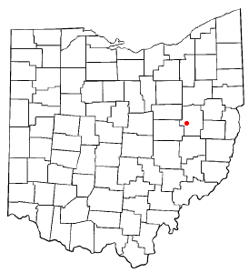
Tuscarawas County is a county located in the northeastern part of the U.S. state of Ohio. As of the 2020 census, the population was 93,263. Its county seat is New Philadelphia. Its name is a Delaware Indian word variously translated as "old town" or "open mouth". Tuscarawas County comprises the New Philadelphia–Dover, OH Micropolitan Statistical Area, which is also included in the Cleveland–Akron–Canton, OH Combined Statistical Area.
Portage County is a county in the U.S. state of Ohio. As of the 2020 census, the population was 161,791. Located in Northeast Ohio, Portage County is part of the Akron Metropolitan Statistical Area, which is also included in the Cleveland–Akron–Canton Combined Statistical Area. Its county seat is Ravenna and its largest city is Kent. The county, named for the portage between the Cuyahoga and Tuscarawas rivers, was created in 1807 and formally organized in 1808. In addition to the cities of Kent and Ravenna, Portage County also includes the cities of Aurora and Streetsboro, along with five villages, 18 civil townships, and several unincorporated places within those townships. Additionally, the county includes parts of the city of Tallmadge, and part of the village of Mogadore, both of which are mostly in neighboring Summit County.
Muskingum County is a county located in the U.S. state of Ohio. As of the 2020 census, the population was 86,410. Its county seat is Zanesville. Nearly bisected by the Muskingum River, the county name is based on a Delaware American Indian word translated as "town by the river" or "elk's eye". Muskingum County comprises the Zanesville, OH Micropolitan Statistical Area, which is also included in the Columbus-Marion-Zanesville, OH Combined Statistical Area. The Zanesville Micropolitan Statistical Area is the second-largest statistical area within the Combined Statistical Area, after the Columbus Metropolitan Statistical Area.
Coshocton is a city in and the county seat of Coshocton County, Ohio, United States, approximately 63 miles (101 km) east-northeast of Columbus. The population was 11,050 at the 2020 census. The Walhonding River and the Tuscarawas River meet in Coshocton to form the Muskingum River.
Canal Fulton is a city in western Stark County, Ohio, United States, along the Tuscarawas River. The population was 5,325 at the time of the 2020 census. It is part of the Canton–Massillon metropolitan area.
Bolivar is a village in Tuscarawas County, Ohio, United States. The population was 1,000 at the 2020 census. Bolivar is also home to Fort Laurens, the only American Revolutionary War-era fort in what is now Ohio.
Mineral City is a village in Tuscarawas County, Ohio, United States. The population was 652 at the 2020 census.
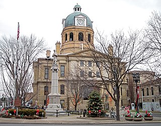
New Philadelphia is a city in and the county seat of Tuscarawas County, Ohio, United States. The county's largest city, New Philadelphia lies along the Tuscarawas River. The population was 17,677 at the 2020 census. It is a principal city in the New Philadelphia–Dover micropolitan area, approximately 70 miles (110 km) south of Cleveland.
Newcomerstown is a village in Tuscarawas County, Ohio, United States, 85 miles (137 km) east-northeast of Columbus. The population was 3,702 at the 2020 census.
Stone Creek is a village in Tuscarawas County, Ohio, United States. The population was 153 at the 2020 census.
Sugarcreek is a village in Tuscarawas County, Ohio, United States. The population was 2,373 at the 2020 census. It is known as "The Little Switzerland of Ohio." Located in Ohio's Amish Country, the village is part of a large regional tourism industry. In the center of town stands one of the world's largest cuckoo clocks, which was previously featured on the cover of the Guinness World Records book in 1977.
Tuscarawas, originally Trenton, is a village in Tuscarawas County, Ohio, United States. The population was 1,035 at the 2020 census.
Lehighton is a borough in Carbon County, Pennsylvania, United States. It is part of Northeastern Pennsylvania. Lehighton is located 117.2 miles (188.6 km) west of New York City and 77.5 miles (124.7 km) northwest of Philadelphia.
Paxtang is a borough in Dauphin County, Pennsylvania, United States. As of the 2020 census it had a population of 1,640. The borough is a suburb of Harrisburg and is one of the earliest colonial settlements in South Central Pennsylvania.
Moravian 47 is an Indian reserve located in Chatham-Kent, Ontario, with an area of 13 square kilometres (5.0 sq mi). It is occupied by the Delaware Nation at Moraviantown First Nation, a part of the Christian Munsee branch of the Lenape, and is commonly known as Moravian of the Thames reserve. The resident registered population is 457, with another 587 band members living off the reserve.
The Gnadenhutten massacre, also known as the Moravian massacre, was the killing of 96 pacifist Moravian Christian Indians by U.S. militiamen from Pennsylvania, under the command of David Williamson, on March 8, 1782, at the Moravian missionary village of Gnadenhutten, Ohio Country, during the American Revolutionary War.
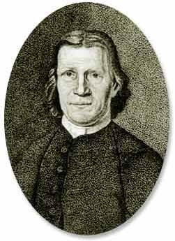
David Zeisberger was a Moravian clergyman and missionary among the Native American tribes who resided in the Thirteen Colonies. He established communities of Munsee (Lenape) converts to Christianity in the valley of the Muskingum River in Ohio; and for a time, near modern-day Amherstburg, Ontario.
The Christian Munsee are a group of Lenape, an Indigenous people in the United States, that primarily speak Munsee and have converted to Christianity, following the teachings of Moravian missionaries. The Christian Munsee are also known as the Moravian Munsee or the Moravian Indians, the Moravian Christian Indians or, in context, simply the Christian Indians. As the Moravian Church transferred some of their missions to other Christian denominations, such as the Methodists, Christian Munsee today belong to the Moravian Church, Methodist Church, United Church of Canada, among other Christian denominations.
David Williamson (1752–1814) was a mass murderer and colonel in the Pennsylvania Militia during the American Revolutionary War. He was born near Carlisle, Pennsylvania, and led American militiamen in the Gnadenhutten massacre of the Moravian Christian Indian Martyrs, though he failed in his plan to massacre the Christian Indians in Schoenbrunn. He led Pennsylvanian soldiers in the massacre of peaceful Delaware Indians in Killbuck Island and was second in command in the Crawford expedition. David Williamson allowed his men to rape women and children in the snow while simultaneously killing them.
Moravian Indian Grants were three tracts of land in Tuscarawas County, Ohio granted by the federal government in the eighteenth century to a group of Christian Indians. In the nineteenth century, these natives moved west, and the government sold the land to white people.
{{cite web}}
: CS1 maint: archived copy as title (link)