
Peoli is an unincorporated community in Washington Township, Tuscarawas County, Ohio, United States. [1] It is located along State Route 258.
Peoli is an unincorporated community in Washington Township, Tuscarawas County, Ohio, United States. [1] It is located along State Route 258.
Situated between Newcomerstown and Freeport, Peoli is made up of approximately ten houses and includes the Peoli Church (1870 – c. 1991), and the Peoli Cemetery—the final resting place of baseball legend Cy Young. Young's house still stands outside of Peoli; it is owned by the Amish community and is currently home to their livestock.
Peoli was originally called Newtown, and under the latter name was laid out in 1817. [2] A post office called Peoli was established in 1846, and remained in operation until 1956, the year after Young's death. [3]
Peoli lies in a rural area, the surrounding terrain consisting of many hills, ridges and valleys.
There are many farms between Peoli and Newcomerstown to the west and Birmingham to the south. There are two tin shops in the Peoli area, one on State Route 258 and one located on a county road just south of the Tuscarawas–Guernsey county line.
Peoli has a large number of Amish people. In 2008 there were two districts of Swartzentruber Amish in the Peoli – Port Washington area. [4]
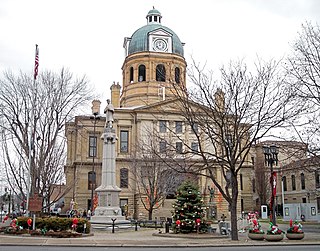
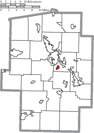
Tuscarawas County is a county located in the northeastern part of the U.S. state of Ohio. As of the 2020 census, the population was 93,263. Its county seat is New Philadelphia. Its name is a Delaware Indian word variously translated as "old town" or "open mouth". Tuscarawas County comprises the New Philadelphia–Dover, OH Micropolitan Statistical Area, which is also included in the Cleveland–Akron–Canton, OH Combined Statistical Area.

Somerdale is an unincorporated community in northeastern Fairfield Township, Tuscarawas County, Ohio, United States. It has a post office with the ZIP code 44678. It lies along State Route 212, Conotton Creek and the Wheeling and Lake Erie Railway east of Zoar.

Stillwater is an unincorporated community in eastern Rush Township, Tuscarawas County, Ohio, United States. It has a post office with the ZIP code 44679. It lies at the intersection of State Routes 258 and 800.
Lock Seventeen is an unincorporated community in Tuscarawas County, in the U.S. state of Ohio.
Bernice is an unincorporated community in rural Washington Township, Tuscarawas County, Ohio, United States. It is located on State Route 258 outside Newcomerstown. It is intersected by Washington Township's Dog and Sleepy Elm roads. Dunlap Creek, a tributary of the Tuscarawas River, flows through Bernice.
Gilmore is an unincorporated community in Washington Township, Tuscarawas County, Ohio, south of the village of Gnadenhutten. Gilmore sits on Tuscarawas County Road 10 and is intersected by Tuscarawas County Road 14 at Gilmore's square.

New Cumberland is an unincorporated community in Warren Township, Tuscarawas County, Ohio, United States. The community is served by the Mineral City, Ohio post office, ZIP code 44656. It is located on Conotton Creek, State Route 212 and the Wheeling and Lake Erie Railway.

State Route 258 is a state highway that runs 25.64 miles (41.26 km) in eastern Ohio. It travels from US 36 in Newcomerstown to SR 800 in Rush Township community of Stillwater. Most of the route is in Tuscarawas County but the route briefly enters Guernsey and Harrison Counties.
Winfield is an unincorporated community in Franklin Township, Tuscarawas County, Ohio, United States. It is on State Route 516 between Dover and Dundee.
Barrs Mills is an unincorporated community in Tuscarawas County, in the U.S. state of Ohio.
Blackband is an unincorporated community in Tuscarawas County, in the U.S. state of Ohio.
Eastport is an unincorporated community in Tuscarawas County, in the U.S. state of Ohio.
Goshen is an unincorporated community in Tuscarawas County, in the U.S. state of Ohio.
Hartwood is an unincorporated community in Tuscarawas County, in the U.S. state of Ohio.
Mount Tabor is an unincorporated community in Tuscarawas County, in the U.S. state of Ohio.

Ragersville is an unincorporated community in Tuscarawas County, in the U.S. state of Ohio.
Rockford is an unincorporated community in Tuscarawas County, in the U.S. state of Ohio.
West Chester is an unincorporated community in Tuscarawas County, in the U.S. state of Ohio.
Wolf is an unincorporated community in Tuscarawas County, in the U.S. state of Ohio.
Yorktown is an unincorporated community in Tuscarawas County, in the U.S. state of Ohio.
Municipalities and communities of Tuscarawas County, Ohio, United States | ||
|---|---|---|
| Cities |  | |
| Villages | ||
| Townships | ||
| CDPs | ||
| Unincorporated communities | ||
| Ghost town | ||
| Footnotes | ‡This populated place also has portions in an adjacent county or counties | |
40°13′38″N81°26′18″W / 40.22722°N 81.43833°W
| | This Tuscarawas County, Ohio state location article is a stub. You can help Wikipedia by expanding it. |