Parral, Ohio

Last updated

Parral, Ohio
Parral Ohio Wooster Ave & Wagner St.jpg
Wooster Avenue
OHMap-doton-Parral.png
Location of Parral, Ohio
Map of Tuscarawas County Ohio Highlighting Parral Village.png
Location of Parral in Tuscarawas County
Coordinates: 40°33′39″N81°29′42″W / 40.56083°N 81.49500°W / 40.56083; -81.49500
Country United States
State Ohio
County Tuscarawas
Township Dover
Area
[1]
  Total0.18 sq mi (0.47 km2)
  Land0.18 sq mi (0.47 km2)
  Water0.00 sq mi (0.00 km2)
Elevation
[2]
922 ft (281 m)
Population
 (2020)
  Total205
  Density1,138.89/sq mi (440.67/km2)
Time zone UTC-5 (Eastern (EST))
  Summer (DST) UTC-4 (EDT)
ZIP code
44622
Area code 330
FIPS code 39-61056 [3]
GNIS feature ID2399627 [2]

Parral is a village in Tuscarawas County, Ohio, United States. The population was 205 at the 2020 census.

Contents

History

Parral was laid out in 1900, and named after Parral, Mexico. [4] A post office called Parral was established in 1902, and remained in operation until 1915. [5]

Geography

According to the United States Census Bureau, the village has a total area of 0.18 square miles (0.47 km2), all land. [6]

Demographics

Historical population
CensusPop.Note
1930 205
1940 2050.0%
1950 199−2.9%
1960 26834.7%
1970 2711.1%
1980 259−4.4%
1990 255−1.5%
2000 241−5.5%
2010 218−9.5%
2020 205−6.0%
U.S. Decennial Census [7]

2010 census

As of the census [8] of 2010, there were 218 people, 100 households, and 65 families living in the village. The population density was 1,211.1 inhabitants per square mile (467.6/km2). There were 106 housing units at an average density of 588.9 per square mile (227.4/km2). The racial makeup of the village was 95.0% White, 0.5% African American, 1.8% from other races, and 2.8% from two or more races. Hispanic or Latino of any race were 2.3% of the population.

There were 100 households, of which 22.0% had children under the age of 18 living with them, 51.0% were married couples living together, 8.0% had a female householder with no husband present, 6.0% had a male householder with no wife present, and 35.0% were non-families. 32.0% of all households were made up of individuals, and 14% had someone living alone who was 65 years of age or older. The average household size was 2.18 and the average family size was 2.71.

The median age in the village was 49 years. 17.4% of residents were under the age of 18; 8.6% were between the ages of 18 and 24; 17.9% were from 25 to 44; 36.2% were from 45 to 64; and 19.7% were 65 years of age or older. The gender makeup of the village was 51.8% male and 48.2% female.

2000 census

As of the census [3] of 2000, there were 241 people, 106 households, and 71 families living in the village. The population density was 1,332.1 inhabitants per square mile (514.3/km2). There were 107 housing units at an average density of 591.4 per square mile (228.3/km2). The racial makeup of the village was 99.17% White and 0.83% from two or more races.

There were 106 households, out of which 28.3% had children under the age of 18 living with them, 58.5% were married couples living together, 6.6% had a female householder with no husband present, and 32.1% were non-families. 27.4% of all households were made up of individuals, and 9.4% had someone living alone who was 65 years of age or older. The average household size was 2.27 and the average family size was 2.78.

In the village, the population was spread out, with 22.4% under the age of 18, 2.1% from 18 to 24, 29.9% from 25 to 44, 29.0% from 45 to 64, and 16.6% who were 65 years of age or older. The median age was 42 years. For every 100 females there were 113.3 males. For every 100 females age 18 and over, there were 114.9 males.

The median income for a household in the village was $35,833, and the median income for a family was $41,023. Males had a median income of $34,250 versus $12,361 for females. The per capita income for the village was $18,021. About 4.0% of families and 7.0% of the population were below the poverty line, including 3.5% of those under the age of eighteen and none of those 65 or over.

Related Research Articles

<span class="mw-page-title-main">Hollandale, Minnesota</span> City in Minnesota, United States

Hollandale is a city on State Highway 251 in Freeborn County, Minnesota, United States. The population was 303 at the 2010 census.

<span class="mw-page-title-main">Cedar Hill Lakes, Missouri</span> Village in Missouri, United States

Cedar Hill Lakes is a village in Jefferson County, Missouri, United States. The population was 203 at the 2020 census.

<span class="mw-page-title-main">Sycamore Hills, Missouri</span> Village in Missouri, United States

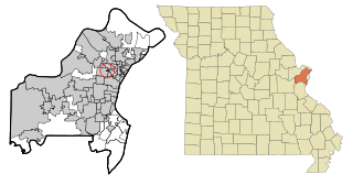
Sycamore Hills is a village in St. Louis County, Missouri, United States. The population is 560 at the 2020 census.

<span class="mw-page-title-main">Hanley Hills, Missouri</span> Village in Missouri, United States

Hanley Hills is a village in St. Louis County, Missouri, United States. The population was 2,101 at the 2010 census.

<span class="mw-page-title-main">Walton Hills, Ohio</span> Village in Ohio, United States

Walton Hills is a village in Cuyahoga County, Ohio, United States. The population was 2,033 at the 2020 census. A suburb of Cleveland, it is a part of the Cleveland metropolitan area.

<span class="mw-page-title-main">Palestine, Ohio</span> Village in Ohio, United States

Palestine is a village in Darke County, Ohio, United States. The population was 180 at the 2020 census.

<span class="mw-page-title-main">Wayne Lakes, Ohio</span> Village in Ohio, United States

Wayne Lakes is a village in Darke County, Ohio, United States. The population was 693 at the 2020 census.

<span class="mw-page-title-main">Addyston, Ohio</span> Village in Ohio, United States

Addyston is a village in Miami Township, Hamilton County, Ohio, United States. Located along the Ohio River, it is a western suburb of the neighboring city of Cincinnati. The population was 927 at the 2020 census.

<span class="mw-page-title-main">Cleves, Ohio</span> City in Ohio, United States

Cleves is a village in Miami Township, Hamilton County, Ohio, United States. Located along the Ohio River, it is a western suburb of Cincinnati. The population was 3,414 at the 2020 census.

<span class="mw-page-title-main">Mowrystown, Ohio</span> Village in Ohio, United States

Mowrystown is a village in Highland County, Ohio, United States. The population was 385 at the 2020 census.

<span class="mw-page-title-main">Darbyville, Ohio</span> Village in Ohio, United States

Darbyville is a village in Pickaway County, Ohio, United States. The population was 186 at the 2020 census.

<span class="mw-page-title-main">Tarlton, Ohio</span> Village in Ohio, United States

Tarlton is a village in Fairfield and Pickaway counties in the U.S. state of Ohio. The population was 254 at the 2020 census.

<span class="mw-page-title-main">Roswell, Ohio</span> Village in Ohio, United States

Roswell is a village in Tuscarawas County, Ohio, United States. The population was 219 at the 2020 census.

<span class="mw-page-title-main">Bethlehem, West Virginia</span> Village in West Virginia, United States

Bethlehem is a village in Ohio County, West Virginia, United States. It is part of the Wheeling, West Virginia Metropolitan Statistical Area. The population was 2,499 at the 2010 census.

<span class="mw-page-title-main">Kekoskee, Wisconsin</span> Village in Wisconsin, United States

Kekoskee is a village in Dodge County, Wisconsin, United States. The population was 161 at the 2010 census.

<span class="mw-page-title-main">Avoca, Wisconsin</span> Village in Wisconsin, United States

Avoca is a village in Iowa County, Wisconsin, United States. The population was 637 at the 2010 census. It is part of the Madison Metropolitan Statistical Area. It is named after Avoca in Ireland.

<span class="mw-page-title-main">Wilson, Ohio</span> Village in Ohio, United States

Wilson is a village in Belmont and Monroe counties in the U.S. state of Ohio. The population was 129 at the 2020 census. It is part of the Wheeling metropolitan area.

<span class="mw-page-title-main">Verona, Ohio</span> Village in Ohio, United States

Verona is a village in Montgomery and Preble counties in the U.S. state of Ohio. The population was 403 at the 2020 census. It is part of the Dayton Metropolitan Statistical Area.

<span class="mw-page-title-main">Lowell, Wisconsin</span> Village in Wisconsin, United States

Lowell is a village in Dodge County, Wisconsin, United States, along the Beaver Dam River. The population was 340 at the 2010 census. The village is located within the Town of Lowell.

<span class="mw-page-title-main">Bloomington, Wisconsin</span> Village in Wisconsin, United States

Bloomington is a village in Grant County, Wisconsin, United States. The population was 735 as of the 2010 census. The village is located within the Town of Bloomington.

References

  1. "ArcGIS REST Services Directory". United States Census Bureau. Retrieved September 20, 2022.
  2. 1 2 U.S. Geological Survey Geographic Names Information System: Parral, Ohio
  3. 1 2 "U.S. Census website". United States Census Bureau . Retrieved January 31, 2008.
  4. Overman, William Daniel (1958). Ohio Town Names. Akron, OH: Atlantic Press. p. 107.
  5. "Post offices". Jim Forte Postal History. Retrieved June 19, 2016.
  6. "US Gazetteer files 2010". United States Census Bureau. Archived from the original on January 12, 2012. Retrieved January 6, 2013.
  7. "Census of Population and Housing". Census.gov. Retrieved June 4, 2015.
  8. "U.S. Census website". United States Census Bureau . Retrieved January 6, 2013.