

The Purchase on the Muskingum also called Ohio Company's Second Purchase, was a tract of land in the Northwest Territory, later Ohio, that the Ohio Company of Associates purchased from the United States federal government in 1792.
The Purchase on the Muskingum also called Ohio Company's Second Purchase, was a tract of land in the Northwest Territory, later Ohio, that the Ohio Company of Associates purchased from the United States federal government in 1792.
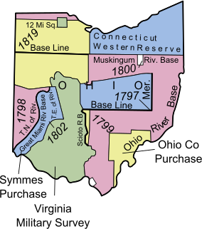
In 1787 the Ohio Company of Associates contracted to buy 1,500,000 acres (6,100 km2) of land in southern Ohio for one million dollars. They ended up only being able to raise $500,000, and so were sold a tract of 750,000 acres (3,000 km2), plus lands set aside for support of local schools, a college, and the clergy, for a total tract size of 913,833 acres (3,698.15 km2) at the confluence of the Ohio River and the Muskingum River. The community of Marietta, Ohio was established in 1788.
The United States granted veterans of the Revolutionary war land bounties for their service because money to pay them was short. The bounty depended upon rank. The associates of the Ohio Company gathered together their bounties in 1792 and accumulated a total of 142,900 acres (578 km2). The government allowed a one third discount on purchases by the Ohio Company, so the government allowed a total sale of 214,285 acres (867.18 km2). [1] These lands were to the north and northwest of the First Purchase in portions of Morgan, Hocking, Vinton and Athens Counties. The Second Purchase was surveyed on the plan of the Land Ordinance of 1785. The Second Purchase had no sections set aside for schools or ministry. [2]

Stockport is a village in Morgan County, Ohio, United States, along the Muskingum River. The population was 503 at the 2010 census.

Lowell is a village in Washington County, Ohio, United States, along the Muskingum River. The population was 549 at the 2010 census.

Marietta is a city in, and the county seat of, Washington County, Ohio, United States. During 1788, pioneers to the Ohio Country established Marietta as the first permanent settlement of the new United States in the Territory Northwest of the River Ohio. Marietta is located in southeastern Ohio at the mouth of the Muskingum River at its confluence with the Ohio River 11 miles northeast of Parkersburg, West Virginia. The population was 14,085 at the 2010 census.

The Northwest Territory in the United States was formed after the American Revolutionary War, and was known formally as the Territory Northwest of the River Ohio. It was the initial post-colonial Territory of the United States and encompassed most of pre-war British colonial territory west of the Appalachian mountains north of the Ohio River. It included all the land west of Pennsylvania, northwest of the Ohio River and east of the Mississippi River below the Great Lakes. It spanned all or large parts of six eventual U.S. States. It was created as a Territory by the Northwest Ordinance July 13, 1787, reduced to Ohio, eastern Michigan and a sliver of southeastern Indiana with the formation of Indiana Territory July 4, 1800, and ceased to exist March 1, 1803, when the southeastern portion of the territory was admitted to the Union as the state of Ohio, and the remainder attached to Indiana Territory.
The Ohio Company of Associates, also known as the Ohio Company, was a land company whose members are today credited with becoming the first non-Native American group to settle in the present-day state of Ohio. In 1788 they established Marietta, Ohio as the first permanent settlement of the new United States in the newly organized Northwest Territory.

The Scioto Company was led by American colonel William Duer, a speculator who worked with a British colleague and several French men to register and organize the company in Paris, France. Ostensibly working with the Ohio Company to purchase land in the Northwest Territory, agents of this institution sold worthless deeds to French people intending to emigrate to the United States. Many were refugees from the excesses of the French Revolution, and the emigrés were made up of minor aristocrats, merchants, artisans and craftsmen. The Scioto Company did not own the land it was selling.
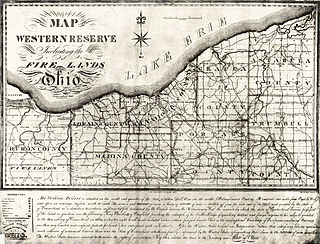
The Firelands, or Sufferers' Lands, tract was located at the western end of the Connecticut Western Reserve in what is now the U.S. state of Ohio. It was legislatively established in 1792, as the "Sufferers' Lands", and later became named "Fire Lands" because the resale of the land was intended as financial restitution for residents of the Connecticut towns of Danbury, Fairfield, Greenwich, Groton, New Haven, New London, Norwalk, and Ridgefield. Their homes had been burned in 1779 and 1781 by British forces during the American Revolutionary War. However, most of the settlement of the area did not occur until after the War of 1812. "Fire Lands" was later spelled as one word: "Firelands."

Rufus Putnam was a colonial military officer during the French and Indian War, and a general in the Continental Army during the American Revolutionary War. As an organizer of the Ohio Company, he was instrumental in the initial settling of the Northwest Territory in present-day Ohio following the war.

The Big Bottom massacre occurred on January 2, 1791, near present-day Stockport now in Morgan County, Ohio, United States. It is considered part of the Northwest Indian Wars, in which aboriginal Americans in the Ohio Country confronted American settlers, regular soldiers and militia, seeking to expel them from their territory.

Benjamin Tupper was a soldier in the French and Indian War, and an officer of the Continental Army during the American Revolutionary War, achieving the rank of brevet brigadier general. Subsequently, he served as a Massachusetts legislator, and he assisted Gen. William Shepard in stopping Shays' Rebellion. Benjamin Tupper was a co-founder of the Ohio Company of Associates, and was a pioneer to the Ohio Country, involved in establishing Marietta, Ohio as the first permanent settlement in the Northwest Territory.

The Ohio Company Land Office is one of the original buildings of the city of Marietta, Ohio, United States. The Office is listed individually in the National Register of Historic Places and as a contributing property to the Marietta Historic District.

The Seven Ranges was a land tract in eastern Ohio that was the first tract to be surveyed in what became the Public Land Survey System. The tract is 42 miles (68 km) across the northern edge, 91 miles (146 km) on the western edge, with the south and east sides along the Ohio River. It consists of all of Monroe, Harrison, Belmont and Jefferson, and portions of Carroll, Columbiana, Tuscarawas, Guernsey, Noble, and Washington County.
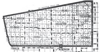
The United States Military District was a land tract in central Ohio that was established by the Congress to compensate veterans of the American Revolutionary War for their service. The tract contains 2,539,110 acres (10,275.4 km2) in Noble, Guernsey, Tuscarawas, Muskingum, Coshocton, Holmes, Licking, Knox, Franklin, Delaware, Morrow, and Marion Counties.
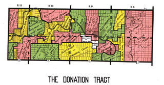
The Donation Tract was a land tract in southern Ohio that was established by the Congress late in the 18th century to buffer Ohio Company lands against Indians. Congress gave 100-acre (0.40 km2) lots to men who settled on the land. This marked the first time that federal land was given without charge to specified settlers, predating the more famous Homestead Act of 1862 by seventy years.

The Congress Lands East of Scioto River was a land tract in southern Ohio that was established by the Congress late in the 18th century. It is located south of the United States Military District and Refugee Tract, west of the Old Seven Ranges, east of the Virginia Military District and north of the Ohio River, French Grant, and the Ohio Company of Associates.
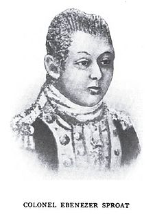
Ebenezer Sproat, surname also spelled Sprout, was an officer of the Continental Army during the American Revolutionary War, a pioneer to the Ohio Country, and one of the founders of Marietta, Ohio, the first permanent American settlement in the Northwest Territory. He served throughout the entire American war of independence, from April 1775 through November 1783, achieving the rank of colonel. After the war, he was a pioneer and surveyor in the Northwest Territory, and became a leader of the militia at Marietta during the Northwest Indian War. He was the first sheriff in the Northwest Territory and Ohio, serving fourteen years as sheriff of Washington County, the oldest county in Ohio.

The Salt Reservations were a collection of land tracts surrounding salt springs in Ohio and some other states that were donated to the states by the federal government early in the 19th century.

Zane's Tracts were three parcels of land in the Northwest Territory of the United States, later Ohio, that the federal government granted to Ebenezer Zane late in the 18th century, as compensation for establishing a road with ferry service over several rivers.

The College Lands were a tract of land in the Northwest Territory, later Ohio, that the Congress donated for the support of a university. Ohio University became the first college northwest of the Ohio River as a beneficiary of this tract.

The Ministerial Lands were tracts of land in the Northwest Territory, later Ohio, that the Congress donated for the support of clergy.
Coordinates: 39°32′05″N82°06′31″W / 39.53472°N 82.10861°W
| Six-Mile Rectangular System Surveys |
|  |
|---|---|---|
| Five-Mile Rectangular System Surveys | ||
| Indiscriminate Surveys | ||
| metes and bounds Survey | ||
| Land Grants | ||
| Other | ||
Images from Commons | ||
| This Ohio state location article is a stub. You can help Wikipedia by expanding it. |