
North and East of the First Principal Meridian is a survey and land description in the northwest part of the U.S. state of Ohio.
North and East of the First Principal Meridian is a survey and land description in the northwest part of the U.S. state of Ohio.
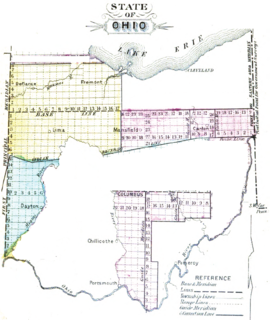
In 1812, Congress authorized the Surveyor General to survey the northern and western border of Ohio “as soon as the consent of the Indians can be obtained.“ [1] In 1817, the northern portion of the Ohio-Indiana border was surveyed and became known as the First Principal Meridian for lands surveyed in the northwest part of Ohio. Most of the lands in Ohio north of the line determined by the Greenville Treaty in 1795 [2] and west of the line determined by the Treaty of Fort Industry in 1805 [3] had been ceded by Indians by 1818 and needed to be surveyed before they could be sold. Lands were surveyed into squares six mile (10 km) on a side called survey townships arranged in a checkerboard pattern, each subdivided into 36 one square mile sections, according to the methods of the Public Land Survey System. The 41st parallel north latitude became the base line. The townships were counted going north from the baseline in vertical rows called ranges. The ranges were counted from one in the west increasing to the east. The sections in each township were numbered in a boustrophedonical sequence according to the Act of May 18, 1796 [4] [5]
The Congress Lands lying east of the meridian, north of the base line, and south of the border with the Michigan Territory at the time were surveyed in 1820-21. [5]
Two military reserves ceded by the Treaty of Greenville of twelve miles square, and two miles square had previously been surveyed, and were not included in the survey. [5] A number of tracts that Native Americans had gained by treaty or Congressional action had also previously been indiscriminately surveyed. [6] At the time Michigan was admitted as a state, the northern boundary of Ohio was moved a few miles further north. These lands between the old and new boundary, called the Toledo Strip, retained their original Michigan Survey based on the Michigan Meridian and baseline.
The Act of March 3, 1819 [7] established the Piqua Land District, with a Land Office in that town for sale of lands in this survey within 48 miles (77 km) of the state of Indiana. For lands in this survey more than 48 miles (77 km) from Indiana, a land office and land district were established at Delaware. The Piqua office was moved to ”Wapaughkoneta“, then, on March 3, 1835, [8] to Lima, and finally, on March 3, 1843, [9] to a consolidated land district at Upper Sandusky. Sales were also conducted from the nation’s capital at the General Land Office. Local offices were eventually closed. The State of Ohio also eventually sold lands granted to them by the federal government, such as section 16 of each township, and the Maumee Road Lands.
The survey tract includes all, or parts of Paulding, Defiance, Williams, Fulton, Henry, Putnam, Hancock, Wood, Lucas, Ottawa, Sandusky, Seneca, and Erie counties.

The Land Ordinance of 1785 was adopted by the United States Congress of the Confederation on May 20, 1785. It set up a standardized system whereby settlers could purchase title to farmland in the undeveloped west. Congress at the time did not have the power to raise revenue by direct taxation, so land sales provided an important revenue stream. The Ordinance set up a survey system that eventually covered over 3/4 of the area of the continental United States.

The Treaty of Fort Meigs, also called the Treaty of the Maumee Rapids, formally titled, "Treaty with the Wyandots, etc., 1817", was the most significant Indian treaty in Ohio since the Treaty of Greenville in 1795, and resulted in cession by the Indians of nearly all remaining Indian lands in northwestern Ohio. It was the last but one and largest wholesale purchase of Indian land in Ohio.

The Surveyor General of the Northwest Territory was a United States government official responsible for surveying land in the Northwest Territory in the United States late in the late eighteenth and early nineteenth century. The position was created in the Land Act of 1796 to survey lands ceded by Native Americans northwest of the Ohio River and above the mouth of the Kentucky River. This act, and those that followed evolved into the Public Land Survey System.

South and East of the First Principal Meridian is a land description in the American Midwest.

The Seven Ranges was a land tract in eastern Ohio that was the first tract to be surveyed in what became the Public Land Survey System. The tract is 42 miles (68 km) across the northern edge, 91 miles (146 km) on the western edge, with the south and east sides along the Ohio River. It consists of all of Monroe, Harrison, Belmont and Jefferson, and portions of Carroll, Columbiana, Tuscarawas, Guernsey, Noble, and Washington County.

Seven Ranges Terminus is a stone surveying marker near Magnolia, Ohio that marks the completion of the first step in opening the lands northwest of the Ohio River to sale and settlement by Americans. This survey marked the first application of the rectangular plan for subdividing land.
The Congress Lands was a group of land tracts in Ohio that made land available for sale to members of the general public through land offices in various cities, and through the General Land Office. It consisted of three groups of surveys:
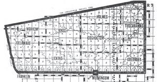
The United States Military District was a land tract in central Ohio that was established by the Congress to compensate veterans of the American Revolutionary War for their service. The tract contains 2,539,110 acres (10,275.4 km2) in Noble, Guernsey, Tuscarawas, Muskingum, Coshocton, Holmes, Licking, Knox, Franklin, Delaware, Morrow, and Marion Counties.

The Congress Lands North of the Old Seven Ranges was a land tract in northeast Ohio that was established by the Congress early in the 19th century. It is located south of the Connecticut Western Reserve and Firelands, east of the Congress Lands South and East of the First Principal Meridian, north of the United States Military District and Seven Ranges, and west of Pennsylvania.
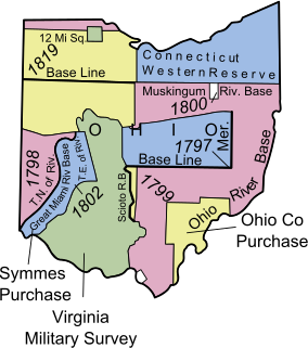
The Congress Lands West of Miami River was a land tract in southwest Ohio that was established by the Congress late in the 18th century. It is located south of the Greenville Treaty Line, east of Indiana, and north of the Great Miami River. The original survey in 1798 contained a triangular shaped slice of land, now located in Indiana, that extended to the Greenville line as it ran from Fort Recovery to opposite the mouth of the Kentucky River.

The Congress Lands East of Scioto River was a land tract in southern Ohio that was established by the Congress late in the 18th century. It is located south of the United States Military District and Refugee Tract, west of the Old Seven Ranges, east of the Virginia Military District and north of the Ohio River, French Grant, and the Ohio Company of Associates.
Maumee Road Lands were a group of land tracts granted by the United States Congress to the state of Ohio in 1823 along the path of a proposed road in the northwest corner of the state.
Turnpike Lands were a group of land tracts granted by the United States Congress to the state of Ohio in 1827 along the path of a proposed road in the northwest corner of the state.

The Salt Reservations were a collection of land tracts surrounding salt springs in Ohio and some other states that were donated to the states by the federal government early in the 19th century.
The Twelve Mile Square Reservation, also called the Twelve Mile Square Reserve, was a tract of land in Ohio ceded by Indians to the United States of America in the Treaty of Greenville in 1795. This particular area of land immediately surrounding Fort Miami was considered to be of strategic importance by the United States government representatives. It was subsequently surveyed in a manner different from surrounding land, and lots sold, or granted, to settlers.
The Two Mile Square Reservation or Two Mile Square Reserve was a tract of land in Ohio ceded by Native Americans to the United States of America in the Treaty of Greenville in 1795. It was subsequently surveyed in a manner different from surrounding land, and lots sold to settlers.

Zane's Tracts were three parcels of land in the Northwest Territory of the United States, later Ohio, that the federal government granted to Ebenezer Zane late in the 18th century, as compensation for establishing a road with ferry service over several rivers.

The Ministerial Lands were tracts of land in the Northwest Territory, later Ohio, that the Congress donated for the support of clergy.
Indian Land Grants were land tracts granted to various Indians by Treaty or by United States Congressional action in the Nineteenth century in northwestern Ohio.
Indian removals in Ohio started in the late eighteenth century after the American victory in the Revolutionary War and the consequent opening of the Northwestern United States to European-American settlement. Native American tribes residing in the region banded together to resist settlement, resulting in the disastrous Northwest Indian War where the Native tribes ceded large swathes of territory to the American government. After the American victory in the war, several Indian reservations were established to forcibly relocate landless tribes to. The process of obtaining full American sovereignty over Indian territories in Ohio was complete around 1818, but continued in Indiana until 1840.
| Six-Mile Rectangular System Surveys |
|  |
|---|---|---|
| Five-Mile Rectangular System Surveys | ||
| Indiscriminate Surveys | ||
| metes and bounds Survey | ||
| Land Grants | ||
| Other | ||
Images from Commons | ||