Congress Lands West of Miami River

Last updated
The Congress Lands West of Miami River are the pink area labeled 1798 in far lower left Ohio Lands.svg
The Congress Lands West of Miami River are the pink area labeled 1798 in far lower left
The Congress Lands West of Miami River West Of Miami River Survey.png
The Congress Lands West of Miami River

The Congress Lands West of Miami River was a land tract in southwest Ohio that was established by the Congress late in the 18th century. It is located south of the Greenville Treaty Line, east of Indiana, and north of the Great Miami River. The original survey in 1798 contained a triangular shaped slice of land, now located in Indiana, that extended to the Greenville line as it ran from Fort Recovery to opposite the mouth of the Kentucky River.

Ohio State of the United States of America

Ohio is a Midwestern state in the Great Lakes region of the United States. Of the fifty states, it is the 34th largest by area, the seventh most populous, and the tenth most densely populated. The state's capital and largest city is Columbus.

Indiana State of the United States of America

Indiana is a U.S. state located in the Midwestern and Great Lakes regions of North America. Indiana is the 38th largest by area and the 17th most populous of the 50 United States. Its capital and largest city is Indianapolis. Indiana was admitted to the United States as the 19th U.S. state on December 11, 1816. Indiana borders Lake Michigan to the northwest, Michigan to the north, Ohio to the east, Kentucky to the south and southeast, and Illinois to the west.

Great Miami River river in the United States of America

The Great Miami River is a tributary of the Ohio River, approximately 160 miles (260 km) long, in southwestern Ohio and Indiana in the United States. The Great Miami flows through Dayton, Piqua, Troy, Hamilton, and Sidney.

Contents

History

In 1787, lands in the Ohio Country east of the Great Miami River were sold by the Continental Congress to Judge John Cleves Symmes of New Jersey, known as Symmes Purchase. With the Treaty of Greenville in 1795, lands west and north of the Miami, and south and east of the Greenville Treaty Line were ceded by Indians, and open to settlement.

Ohio Country Historical region in North America

The Ohio Country was a name used in the mid to late 18th century for a region of North America west of the Appalachian Mountains and north of the upper Ohio and Allegheny Rivers extending to Lake Erie. The area encompassed roughly all of present-day Ohio, northwestern West Virginia, Western Pennsylvania, and a wedge of southeastern Indiana.

Continental Congress convention of delegates that became the governing body of the United States

The Continental Congress, also known as the Philadelphia Congress, was a convention of delegates called together from the Thirteen Colonies. It became the governing body of the United States during the American Revolution. The Congress met from 1774 to 1789 in three incarnations. The first call for a convention was made over issues of the blockade and the Intolerable Acts penalizing the Province of Massachusetts Bay. In 1774 Benjamin Franklin convinced the colonial delegates to the Congress to form a representative body. Much of what is known today comes from the yearly log books printed by the Continental Congress called Resolutions, Acts and Orders of Congress, which gives a day-to-day description of debates and issues.

John Cleves Symmes American politician

John Cleves Symmes was a delegate to the Continental Congress from New Jersey, and later a pioneer in the Northwest Territory. He was also the father-in-law of President William Henry Harrison.

The survey

The survey commenced in 1798. Land was to be systematically surveyed into square "townships", six miles (9.656 km) on a side created by lines running north-south intersected by east-west lines. Townships were to be arranged in north-south rows called ranges. These townships were sub-divided into thirty-six "sections" of one square mile (2.59 km²) or 640 acres. These ranges, townships, and sections were to be systematically numbered. [1] The First Principal Meridian was established to run northward from the confluence of the Great Miami River and the Ohio River. Ranges were numbered east and west from this meridian. Townships east of the meridian were numbered from south to north, starting at the Great Miami River. Townships west of the meridian were numbered from south to north starting at the Ohio River. Thus, townships in adjacent ranges rarely have the same number. [2] Sections in each township are numbered according to the plan adopted in the Act of May 18, 1796. [3] The Ohio Enabling Act of 1802 established the western boundary of the state along the First Principal Meridian. [1] [4]

Survey township mostly-square areas used for land descriptions in the U.S.

Survey township, sometimes called Congressional township, as used by the United States Public Land Survey System, refers to a square unit of land, that is nominally six miles (~9.7 km) on a side. Each 36-square-mile (~93 km2) township is divided into 36 one-square-mile (~2.6 km2) sections, that can be further subdivided for sale, and each section covers a nominal 640 acres (2.6 km2). The townships are referenced by a numbering system that locates the township in relation to a principal meridian (north-south) and a base line (east-west). For example, Township 2 North, Range 4 East is the 4th township east of the principal meridian and the 2nd township north of the base line. Township (exterior) lines were originally surveyed and platted by the US General Land Office using contracted private survey crews. Later survey crews subdivided the townships into sections (interior) lines. Virtually all lands covered by this system were sold according to these boundaries. They are marked on the U.S. Geological Survey topographic maps.

Section (United States land surveying) square subdivision of a U.S. survey township

In U.S. land surveying under the Public Land Survey System (PLSS), a section is an area nominally one square mile, containing 640 acres, with 36 sections making up one survey township on a rectangular grid.

Ohio River river in the midwestern United States

The Ohio River is a 981-mile (1,579 km) long river in the midwestern United States that flows southwesterly from western Pennsylvania south of Lake Erie to its mouth on the Mississippi River at the southern tip of Illinois. It is the second largest river by discharge volume in the United States and the largest tributary by volume of the north-south flowing Mississippi River that divides the eastern from western United States. The river flows through or along the border of six states, and its drainage basin includes parts of 15 states. Through its largest tributary, the Tennessee River, the basin includes several states of the southeastern U.S. It is the source of drinking water for three million people.

General Land Office plan for numbering sections of a standard survey township, adopted May 18, 1796 Theoreticaltownshipmap.gif
General Land Office plan for numbering sections of a standard survey township, adopted May 18, 1796

Land sales

Section 4 of the Land Act of May 18, 1796 provided that the lands in the survey area be sold at Cincinnati. The Land Act of May 10, 1800 [5] established a Federal Land Office at Cincinnati for sales of these lands. Sales were also conducted from the nation’s capital at the General Land Office. Local offices were eventually closed. The State of Ohio also eventually sold lands granted to them by the federal government, such as section 16 of each township.

General Land Office former agency of the US Department of the Interior

The General Land Office (GLO) was an independent agency of the United States government responsible for public domain lands in the United States. It was created in 1812 to take over functions previously conducted by the United States Department of the Treasury. Starting with the passage of the Land Ordinance of 1785, which created the Public Land Survey System, the Treasury Department had already overseen the survey of the "Northwest Territory", including what is now the state of Ohio.

School Lands sections of land sold or used by school systems

School Lands are land grants established in support of education. Support for public education in the United States predates the constitution; two years before the adoption of the United States Constitution of 1787, the Congress of the Confederation provided support for public schooling by establishing the land grants in the Land Ordinance of May 20, 1785 which granted Section 16 of every township to be used for public education: "There shall be reserved the Lot No. 16, of every township, for the maintenance of public schools within said township."

College Township

Congress declared in September, 1803 that 23,321 acres (36.4 square miles) located in the Congress Lands West of Miami River were to be set aside for “an academy, other public schools and seminaries of learning.” It benefited Miami University, chartered in 1809 by the state legislature in a town the legislature named Oxford. [6] The College Township is in township 5 of range 1 east, now the civil township called Oxford Township, Butler County, Ohio.

Miami University Public research university located in Oxford, Ohio, United States

Miami University is a public research university in Oxford, Ohio. The university was founded in 1809, although classes were not held until 1824. Miami University is the second-oldest university in Ohio and the 10th oldest public university in the United States. Miami also has regional campuses in Hamilton, Middletown and West Chester, as well as the Dolibois European Center in Differdange, Luxembourg. The Carnegie Foundation classifies Miami University as a research university with a high research activity. It is affiliated with the University System of Ohio.

Oxford, Ohio City in Ohio, United States

Oxford is a city in Butler County, Ohio, United States, in the southwestern portion of the state approximately 28 mi (46 km) NW of Cincinnati. It lies in Oxford Township, originally called the College Township. The population was 21,371 at the 2010 census. This college town was founded as a home for Miami University. In 2014, Oxford was rated by Forbes as the "Best College Town" in the United States, based on a high percentage of students per capita and part-time jobs, and a low occurrence of brain-drain.

College Township

The "College Township" was the full survey township located in the northwest corner of Butler County, Ohio, now corresponding to the civil township of Oxford, designated by the Ohio General Assembly to be the site of the state university now called Miami University. When Congress, on May 5, 1792, authorized the sale to John Cleves Symmes of the land known as the Symmes Purchase, one of the terms was that he would allocate a full township of land to support a university, a promise he never fulfilled. The United States Congress subsequently allowed the State of Ohio to pick a township in the public domain for a college. They chose a township in the first range in the Congress Lands, namely R1E T5.

Modern times

The survey in Ohio in modern times includes all or parts of nine counties: Butler, Darke, Hamilton, Logan, Mercer, Miami, Montgomery, Preble, and Shelby

Butler County, Ohio County in the United States

Butler County is a county in the U.S. state of Ohio. As of the 2010 census, the population was 368,130. Its county seat is Hamilton. It is named for General Richard Butler, who died in 1791 during St. Clair's Defeat. Located along the Miami River, it is home to Miami University, an Ohio public university that was founded in 1809 as the second university in the State of Ohio.

Darke County, Ohio County in the United States

Darke County is a county in the U.S. state of Ohio. As of the 2010 census, the population was 52,959. Its county seat is Greenville. The county was created in 1809 and later organized in 1817. It is named for William Darke, an officer in the American Revolutionary War.

Hamilton County, Ohio County in the United States

Hamilton County is a county in the southwest corner of the U.S. state of Ohio. As of the 2010 census, the population was 802,374. making it the third-most populous county in Ohio. The county seat is Cincinnati. The county is named for the first Secretary of the Treasury, Alexander Hamilton.

See also

Notes

  1. 1 2 Knepper, p. 42-43.
  2. Peters, p. 164.
  3. 1  Stat.   464 - Text of Act of May 18, 1796 Library of Congress
  4. 2  Stat.   173 - Text of Act of April 30, 1802 Library of Congress
  5. 2  Stat.   73 - Text of Act of May 10, 1800 Library of Congress
  6. Knepper, p. 68.

Related Research Articles

Treaty of Greenville 1795 treaty ending the Northwest Indian War

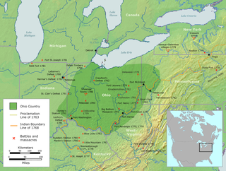
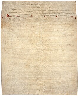
The Treaty of Greenville, formally titled Treaty with the Wyandots, etc., was a 1795 treaty between the United States and Indians of the Northwest Territory including the Wyandot and Delaware, which redefined the boundary between Indian lands and Whiteman's lands in the Northwest Territory.

Land Ordinance of 1785

The Land Ordinance of 1785 was adopted by the United States Congress of the Confederation on May 20, 1785. It set up a standardized system whereby settlers could purchase title to farmland in the undeveloped west. Congress at the time did not have the power to raise revenue by direct taxation, so land sales provided an important revenue stream. The Ordinance set up a survey system that eventually covered over 3/4 of the area of the continental United States.

Ohio Lands

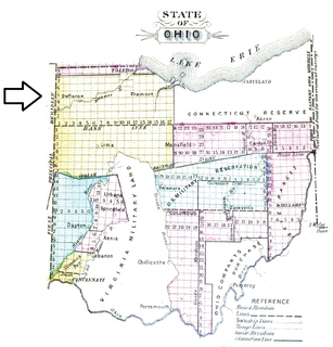
The Ohio Lands were the several grants, tracts, districts and cessions which make up what is now the U.S. state of Ohio. The Ohio Country was one of the first settled parts of the Midwest, and indeed one of the first settled parts of the United States beyond the original 13 colonies. The land that became first the anchor of the Northwest Territory and later Ohio was cobbled together from a variety of sources and owners.

Surveyor General of the Northwest Territory former appointed political position in the US

The Surveyor General of the Northwest Territory was a United States government official responsible for surveying land in the Northwest Territory in the United States late in the late eighteenth and early nineteenth century. The position was created in the Land Act of 1796 to survey lands ceded by Indians northwest of the Ohio River and above the mouth of the Kentucky River. This act, and those that followed evolved into the Public Land Survey System.

South and East of the First Principal Meridian

South and East of the First Principal Meridian is a land description in the American Midwest.

Seven Ranges

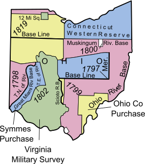
The Seven Ranges was a land tract in eastern Ohio that was the first tract to be surveyed in what became the Public Land Survey System. The tract is 42 miles (68 km) across the northern edge, 91 miles (146 km) on the western edge, with the south and east sides along the Ohio River. It consists of all of Monroe, Harrison, Belmont and Jefferson, and portions of Carroll, Columbiana, Tuscarawas, Guernsey, Noble, and Washington County.

Congress Lands

The Congress Lands was a group of land tracts in Ohio that made land available for sale to members of the general public through land offices in various cities, and through the General Land Office. It consisted of three groups of surveys:

United States Military District

The United States Military District was a land tract in central Ohio that was established by the Congress to compensate veterans of the American Revolutionary War for their service. The tract contains 2,539,110 acres (10,275.4 km2) in Noble, Guernsey, Tuscarawas, Muskingum, Coshocton, Holmes, Licking, Knox, Franklin, Delaware, Morrow, and Marion Counties.

Congress Lands North of Old Seven Ranges

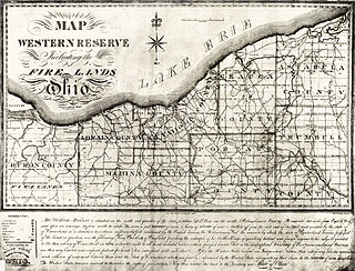
The Congress Lands North of the Old Seven Ranges was a land tract in northeast Ohio that was established by the Congress early in the 19th century. It is located south of the Connecticut Western Reserve and Firelands, east of the Congress Lands South and East of the First Principal Meridian, north of the United States Military District and Seven Ranges, and west of Pennsylvania.

Congress Lands East of Scioto River

The Congress Lands East of Scioto River was a land tract in southern Ohio that was established by the Congress late in the 18th century. It is located south of the United States Military District and Refugee Tract, west of the Old Seven Ranges, east of the Virginia Military District and north of the Ohio River, French Grant, and the Ohio Company of Associates.

Maumee Road Lands

Maumee Road Lands were a group of land tracts granted by the United States Congress to the state of Ohio in 1823 along the path of a proposed road in the northwest corner of the state.

Turnpike Lands were a group of land tracts granted by the United States Congress to the state of Ohio in 1827 along the path of a proposed road in the northwest corner of the state.

Salt Reservations

The Salt Reservations were a collection of land tracts surrounding salt springs in Ohio and some other states that were donated to the states by the federal government early in the 19th century.

Twelve Mile Square Reservation

The Twelve Mile Square Reservation, also called the Twelve Mile Square Reserve, was a tract of land in Ohio ceded by Indians to the United States of America in the Treaty of Greenville in 1795. This particular area of land immediately surrounding Fort Miami was considered to be of strategic importance by the United States government representatives. It was subsequently surveyed in a manner different from surrounding land, and lots sold, or granted, to settlers.

Two Mile Square Reservation

The Two Mile Square Reservation or Two Mile Square Reserve was a tract of land in Ohio ceded by Native Americans to the United States of America in the Treaty of Greenville in 1795. It was subsequently surveyed in a manner different from surrounding land, and lots sold to settlers.

North and East of First Principal Meridian

North and East of the First Principal Meridian is a survey and land description in the northwest part of the American state called Ohio.

Zanes Tracts

Zane's Tracts were three parcels of land in the Northwest Territory of the United States, later Ohio, that the federal government granted to Ebenezer Zane late in the 18th century, as compensation for establishing a road with ferry service over several rivers.

Ministerial Lands

The Ministerial Lands were tracts of land in the Northwest Territory, later Ohio, that the Congress donated for the support of clergy.

Indian Land Grants

Indian Land Grants were land tracts granted to various Indians by Treaty or by United States Congressional action in the Nineteenth century in northwestern Ohio.

Moravian Indian Grants

Moravian Indian Grants were three tracts of land in Tuscarawas County, Ohio granted by the federal government in the eighteenth century to a group of Christian Indians. In the nineteenth century, these natives moved west, and the government sold the land to white people.

References

Coordinates: 39°35′N84°38′W / 39.59°N 84.63°W / 39.59; -84.63