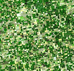
Section (United States land surveying)

Last updated
Sectioning a township (36 sections). Theoreticaltownshipmap.gif
Sectioning a township (36 sections).
Perfectly square 160-acre quarter sections of farmland cover central Indiana. Indy farmland.jpg
Perfectly square 160-acre quarter sections of farmland cover central Indiana.
Satellite image of crops growing in southwest Kansas, mainly using center pivot irrigation. The primary grid pattern is of quarter sections (
.mw-parser-output .frac{white-space:nowrap}.mw-parser-output .frac .num,.mw-parser-output .frac .den{font-size:80%;line-height:0;vertical-align:super}.mw-parser-output .frac .den{vertical-align:sub}.mw-parser-output .sr-only{border:0;clip:rect(0,0,0,0);clip-path:polygon(0px 0px,0px 0px,0px 0px);height:1px;margin:-1px;overflow:hidden;padding:0;position:absolute;width:1px}
1/2 mi x 1/2 mi (800 m x 800 m)). Crops Kansas AST 20010624.jpg
Satellite image of crops growing in southwest Kansas, mainly using center pivot irrigation. The primary grid pattern is of quarter sections (12 mi × 12 mi (800 m × 800 m)).

In U.S. land surveying under the Public Land Survey System (PLSS), a section is an area nominally one square mile (2.6 square kilometers), containing 640 acres (260 hectares), with 36 sections making up one survey township on a rectangular grid. [1]

Contents

The legal description of a tract of land under the PLSS includes the name of the state, name of the county, township number, range number, section number, and portion of a section. Sections are customarily surveyed into smaller squares by repeated halving and quartering. A quarter section is 160 acres (65 ha) and a "quarter-quarter section" is 40 acres (16 ha). In 1832 the smallest area of land that could be acquired was reduced to the 40-acre (16 ha) quarter-quarter section, and this size parcel became entrenched in American mythology. After the Civil War, freedmen (freed slaves) were reckoned to be self-sufficient with "40 acres and a mule." In the 20th century real estate developers preferred working with 40-acre (16 ha) parcels. [2] The phrases "front 40" and "back 40," referring to farm fields, indicate the front and back quarter-quarter sections of land.

One of the reasons for creating sections of 640 acres (260 ha) was the ease of dividing into halves and quarters while still maintaining a whole number of acres. A section can be halved seven times in this way, down to a 5-acre (2 ha) parcel, or half of a quarter-quarter-quarter section—an easily surveyed 50-square-chain (2 ha) area. This system was of great practical value on the American frontier, where surveyors often had a shaky grasp of mathematics and were required to work quickly. [2]

A description of a quarter-quarter section in standard abbreviated form, might look like "NW 1/4, NE 1/4, Sec. 34, T.3S, R.1W, 1st P.M." or, alternatively, "34-3-1 NW4NE4 1PM". In expanded form this would read "the Northwest quarter of the Northeast quarter of Section 34 of Township 3 South, Range 1 West, first Principal Meridian". [3]

History

The existence of section lines made property descriptions far more straightforward than the old metes and bounds system. The establishment of standard east-west and north-south lines ("township" and "range lines") meant that deeds could be written without regard to temporary terrain features such as trees, piles of rocks, fences, and the like, and be worded in the style such as "Lying and being in Township 4 North; Range 7 West; and being the northwest quadrant of the southwest quadrant of said section," an exact description in this case of 40 acres, as there are 640 acres (260 ha) in a square mile.

The importance of "sections" was greatly enhanced by the passage of "An Ordinance for ascertaining the mode of disposing of lands in the Western Territory" of 1785 by the U.S. Congress (see Land Ordinance of 1785). This law provided that lands outside the then-existing states could not be sold, otherwise distributed, or opened for settlement prior to being surveyed. The standard way of doing this was to divide the land into sections. An area six sections by six sections would define a township. Within this area, one section was designated as school land. As the entire parcel would not be necessary for the school and its grounds, the balance of it was to be sold, with the monies to go into the construction and upkeep of the school.

On May 20, 1862, President Abraham Lincoln signed into law the Homestead Act, by which settlers could "claim" 160 acres (a quarter section) of public land. Claimants were required to "live on" and “improve” their plot by cultivating the land. After five years, the original filer of the claim was entitled to the property, free and clear, except for a small registration fee. [4]

Roads and urban planning

Numbering within a township

Section map of Rock Creek Township, Saunders County, Nebraska (1907) Plat book of Saunders County, Nebraska - containing carefully prepared township plats, village plats, analysis of U.S. land system, leading farmers directory - illustrated. LOC 2007626721-19.tif
Section map of Rock Creek Township, Saunders County, Nebraska (1907)

Every township is divided into 36 sections, each usually 1 mile (1.6 km) square. Sections are numbered boustrophedonically within townships [3] as follows (north at top):

654321
789101112
181716151413
192021222324
302928272625
313233343536

Section subdivisions

Sections can be divided into quarter sections of 160 acres (65 ha), named by intercardinal direction (northwest, northeast, etc.). For instance, the southwest quarter of a section is named SW 1/4. [5]

NWNE
SWSE

Sections can be further broken up into 40-acre (16 ha) blocks, or quarter-quarter sections. These add a second intercardinal direction label. For instance, the southeast quarter of the southwest quarter section mentioned above is labeled SE 1/4, SW 1/4: [5] [6]

NWNWNENWNWNENENE
SWNWSENWSWNESENE
NWSWNESWNWSENESE
SWSWSESWSWSESESE

Measurement anomalies

The curvature of the Earth makes it impossible to superimpose a regular grid on its surface, as the meridians converge toward the North Pole. As the U.S. is in the Northern Hemisphere, if a section's or township's east and west sides lie along meridians, its north side is shorter than its south side. As sections were surveyed from south and east to north and west, accumulated errors and distortions resulted on the north and west lines, and north and west sections diverge the most from the ideal shape and size.

The entire township grid shifts to account for the Earth's curvature. Where the grid is corrected, or where two grids based on different principal meridians meet, section shapes are irregular.

Sections also differ from the PLSS ideal of one square mile for other reasons, including errors and sloppy work by surveyors, poor instrumentation, and difficult terrain. In addition, the primary survey tool was the magnetic compass, which is influenced by local irregularities.

Once established, even an imperfect grid remains in force, mainly because the monuments of the original survey, when recovered, hold legal precedent over subsequent resurveys. [3]

Alternatives and legacy systems

The Public Land Survey System was not the first to define and implement a survey grid. A number of similar systems were established, often using terms like section and township but not necessarily in the same way. For example, the lands of the Holland Purchase in western New York were surveyed into a township grid before the PLSS was established. In colonial New England land was often divided into squares called towns or townships, and further subdivided into parcels called lots or sections. [2]

Sections are also used in land descriptions in the portion of northwestern Georgia that was formerly part of the territory of the Cherokee Nation. They are not, however, part of the PLSS and are irregular in shape and size. See Cherokee County, Georgia for more information on the historical reasons for this.

Another exception to the usual use of sections and section numbering occurs when most of a parcel, or lot, falls under a body of water. The term "government lot" is used for such parcels and they are usually described separately from the rest of the section using single numbers (such as "Government Lot 5 of Section 15"). Also, parcels within a platted subdivision are often specified by lot number rather than using PLSS descriptions. [3]

Where Spanish land grants in Florida have descriptions that predate PLSS or even the U.S. itself, deviation from typical section numbering and size and shape often takes place. In an effort to honor these land grants after the U.S. took control of Florida, surveyors would use descriptions from confirmed land grants to establish their initial boundaries and created PLSS sections that extrapolated from those lines. Often, the amount of land left over in areas immediately surrounding the grants was grossly undersized or awkwardly shaped. Those tracts are referred to as "fractional sections" and often are not subject to township or range definitions. An example of such a legal description's beginning would read "Being a portion of Fractional Sec. 59, Township 0 South, Range 0 West".

Also, land north of the Watson Line near the Georgia border was not subject to the standard U.S. section, township and range designations, since the State of Georgia had claimed and laid out counties and surveyed its public lands south to that line into what eventually became part of the State of Florida. The exact location of the Georgia–Florida state line was ultimately confirmed by an Act of Congress, approved April 9, 1872.

See also

Related Research Articles

<span class="mw-page-title-main">Public Land Survey System</span> System of dividing land in the United States

The Public Land Survey System (PLSS) is the surveying method developed and used in the United States to plat, or divide, real property for sale and settling. Also known as the Rectangular Survey System, it was created by the Land Ordinance of 1785 to survey land ceded to the United States by the Treaty of Paris in 1783, following the end of the American Revolution. Beginning with the Seven Ranges in present-day Ohio, the PLSS has been used as the primary survey method in the United States. Following the passage of the Northwest Ordinance in 1787, the Surveyor General of the Northwest Territory platted lands in the Northwest Territory. The Surveyor General was later merged with the United States General Land Office, which later became a part of the U.S. Bureau of Land Management (BLM). Today, the BLM controls the survey, sale, and settling of lands acquired by the United States.

The Dominion Land Survey is the method used to divide most of Western Canada into one-square-mile (2.6 km2) sections for agricultural and other purposes. It is based on the layout of the Public Land Survey System used in the United States, but has several differences. The DLS is the dominant survey method in the Prairie provinces, and it is also used in British Columbia along the Railway Belt, and in the Peace River Block in the northeast of the province.

A township in some states of the United States is a small geographic area.

<span class="mw-page-title-main">Land Ordinance of 1785</span> United States law on western land and surveying

The Land Ordinance of 1785 was adopted by the United States Congress of the Confederation on May 20, 1785. It set up a standardized system whereby settlers could purchase title to farmland in the undeveloped west. Congress at the time did not have the power to raise revenue by direct taxation, so land sales provided an important revenue stream. The Ordinance set up a survey system that eventually covered over three-quarters of the area of the continental United States.

<span class="mw-page-title-main">Survey township</span> Area of land used in US land surveys

A survey township, sometimes called a Congressional township or just township, as used by the United States Public Land Survey System and by Canada's Dominion Land Survey is a nominally-square area of land that is nominally six survey miles on a side. Each 36-square-mile township is divided into 36 sections of one square mile each. The sections can be further subdivided for sale.

<span class="mw-page-title-main">Concession road</span> Type of road in pre-Confederation Canada

In Upper and Lower Canada, concession roads were laid out by the colonial government through undeveloped Crown land to provide access to rows of newly surveyed lots intended for farming by new settlers. The land that comprised a row of lots that spanned the entire length of a new township was "conceded" by the Crown for this purpose. Title to an unoccupied lot was awarded to an applicant in exchange for raising a house, performing roadwork and land clearance, and monetary payment. Concession roads and cross-cutting sidelines or sideroads were laid out in an orthogonal grid plan, often aligned so that concession roads ran (approximately) parallel to the north shore of Lake Ontario, or to the southern boundary line of a county.

<span class="mw-page-title-main">Plat</span> Map showing divisions of a piece of land in America

In the United States, a plat (plan) is a cadastral map, drawn to scale, showing the divisions of a piece of land. United States United States General Land Office surveyors drafted township plats of Public Lands Surveys to show the distance and bearing between section corners, sometimes including topographic or vegetation information. City, town or village plats show subdivisions broken into blocks with streets and alleys. Further refinement often splits blocks into individual lots, usually for the purpose of selling the described lots; this has become known as subdivision.

<span class="mw-page-title-main">Willamette Stone</span> Historic surveying marker in Oregon, US

The Willamette Stone was a small stone obelisk originally installed by the Department of Interior in 1885 in the western hills of Portland, Oregon in the United States to mark the intersection and origin of the Willamette meridian and Willamette baseline. It replaced a cedar stake placed by the Surveyor General of the Oregon Territory in 1851; this stake defined the grid system of sections and townships from which all real property in the states of Oregon and Washington has been measured following the Donation Land Claim Act of 1850. The Willamette meridian runs north–south, and the Willamette baseline runs east–west through the marker. The easternmost northeast corner of Washington County is sited on the marker.

A range road in Canada is a road that runs north–south along a range grid line of the Dominion Land Survey. Range roads are perpendicular to township roads which run east–west along the township grid lines.

An arpent is a unit of length and a unit of area. It is a pre-metric French unit based on the Roman actus. It is used in Quebec, some areas of the United States that were part of French Louisiana, and in Mauritius and the Seychelles.

In surveying and property law, a land description or legal description is a written statement that delineates the boundaries of a piece of real property. In the written transfer of real property, it is universally required that the instrument of conveyance (deed) include a written description of the property.

The Alberta Township System (ATS) is a land surveying system used in the Canadian province of Alberta and other parts of western Canada.

<span class="mw-page-title-main">Fifth principal meridian</span>

The Fifth principal meridian, often denoted the "5th Meridian" or "PM 05," is a principal meridian survey line used in the United States for land claims in the Public Land Survey System (PLSS). It was first surveyed in 1815. The meridian, a north-south line, starts from the old mouth of the Arkansas River and runs north. Another survey line related to it is the base line running west from the old mouth of the St. Francis River. These survey lines govern all land surveys in four states and a large portion of the land surveys for two more. Monuments have been erected where the two lines meet at 34°38′44″N91°3′42″W, and the surveyors' skill has been commemorated at the Louisiana Purchase State Park in eastern Arkansas. The Fifth principal meridian is nearly coincident with 91° 3′ 42″ longitude west from the Greenwich meridian.

<span class="mw-page-title-main">Seven Ranges</span> Land tract in eastern Ohio, US

The Seven Ranges was a land tract in eastern Ohio that was the first tract to be surveyed in what became the Public Land Survey System. The tract is 42 miles (68 km) across the northern edge, 91 miles (146 km) on the western edge, with the south and east sides along the Ohio River. It consists of all of Monroe, Harrison, Belmont and Jefferson, and portions of Carroll, Columbiana, Tuscarawas, Guernsey, Noble, and Washington County.

<span class="mw-page-title-main">Congress Lands</span>

The Congress Lands was a group of land tracts in Ohio that made land available for sale to members of the general public through land offices in various cities, and through the United States General Land Office. It consisted of three groups of surveys:

<span class="mw-page-title-main">United States Military District</span>

The United States Military District was a land tract in central Ohio that was established by the Congress to compensate veterans of the American Revolutionary War for their service. The tract contains 2,539,110 acres (10,275.4 km2) in Noble, Guernsey, Tuscarawas, Muskingum, Coshocton, Holmes, Licking, Knox, Franklin, Delaware, Morrow, and Marion counties.

<span class="mw-page-title-main">Congress Lands West of Miami River</span>

The Congress Lands West of Miami River was a land tract in southwest Ohio that was established by the Congress late in the 18th century. It is located south of the Greenville Treaty Line, east of Indiana, and north of the Great Miami River. The original survey in 1798 contained a triangular shaped slice of land, now located in Indiana, that extended to the Greenville line as it ran from Fort Recovery to opposite the mouth of the Kentucky River.

<span class="mw-page-title-main">Congress Lands East of Scioto River</span>

The Congress Lands East of Scioto River was a land tract in southern Ohio that was established by the Congress late in the 18th century. It is located south of the United States Military District and Refugee Tract, west of the Old Seven Ranges, east of the Virginia Military District and north of the Ohio River, French Grant, and the Ohio Company of Associates.

<span class="mw-page-title-main">Two Mile Square Reservation</span>

The Two Mile Square Reservation or Two Mile Square Reserve was a tract of land in Ohio ceded by Native Americans to the United States of America in the Treaty of Greenville in 1795. It was subsequently surveyed in a manner different from surrounding land, and lots sold to settlers.

<span class="mw-page-title-main">Butts and bounds</span> On legal deeds and their content

Butts and bounds, shortened form for "abuttals and boundaries" of a property, are the boundary lines delineated between plots of land, usually those which define the end of an estate, as used in legal deeds, titles, etc. These are usually descriptive features in the property, such as trees, outcroppings of stone, or riverine brooks, etc., and are signified in the legal deed for purposes of identification.

References

  1. White, C. Albert (1983). A History of the Rectangular Survey System (PDF). Washington, D.C.: United States Bureau of Land Management.
  2. 1 2 3 Linklater, Andro (2002). Measuring America: How the United States Was Shaped By the Greatest Land Sale in History . Plume. pp.  72, 166, 234. ISBN   0-452-28459-7.
  3. 1 2 3 4 Muehrcke, Phillip C.; Muehrcke, Juliana O.; Kimerling, A. Jon (2001). Map Use: Reading, Analysis, and Interpretation (4th ed.). JP Publications. pp. 234–239. ISBN   0-9602978-5-5.
  4. "Homestead Act (1862)". 29 July 2021.
  5. 1 2 "Tutorial on the Public Land Survey System Descriptions" (PDF). Wisconsin Department of Natural Resources. Retrieved 2020-01-14.
  6. Murray, William Gordon (1969). Farm Appraisal and Valuation (5th ed.). Ames: Iowa State University Press. p. 53. ISBN   9780813805702. OCLC   246381719.

Further reading