
The Louisiana Purchase was the acquisition of the Louisiana territory by the United States from France in 1803. The U.S. paid fifty million francs ($11,250,000) and a cancellation of debts worth eighteen million francs ($3,750,000) for a total of sixty-eight million francs. The Louisiana territory included land from fifteen present U.S. states and two Canadian provinces. The territory contained land that forms Arkansas, Missouri, Iowa, Oklahoma, Kansas, and Nebraska; the portion of Minnesota west of the Mississippi River; a large portion of North Dakota; a large portion of South Dakota; the northeastern section of New Mexico; the northern portion of Texas; the area of Montana, Wyoming, and Colorado east of the Continental Divide; Louisiana west of the Mississippi River ; and small portions of land within the present Canadian provinces of Alberta and Saskatchewan. Its non-native population was around 60,000 inhabitants, of whom half were African slaves.

The Royal Proclamation of 1763 was issued by King George III on October 7, 1763, following Great Britain's acquisition of French territory in North America after the end of the French and Indian War/Seven Years' War. This proclamation rendered all land grants given by the government to British subjects who fought for the Crown against France worthless. It forbade all settlement west of a line drawn along the Appalachian Mountains, which was delineated as an Indian Reserve.

The Treaty of Guadalupe Hidalgo, officially titled the Treaty of Peace, Friendship, Limits and Settlement between the United States of America and the Mexican Republic, is the peace treaty signed on February 2, 1848, in the Villa de Guadalupe Hidalgo between the United States and Mexico that ended the Mexican–American War (1846–1848). The treaty came into force on July 4, 1848.

The Adams–Onís Treaty of 1819, also known as the Transcontinental Treaty, the Florida Purchase Treaty, or the Florida Treaty, was a treaty between the United States and Spain in 1819 that ceded Florida to the U.S. and defined the boundary between the U.S. and New Spain. It settled a standing border dispute between the two countries and was considered a triumph of American diplomacy. It came in the midst of increasing tensions related to Spain's territorial boundaries in North America against the United States and Great Britain in the aftermath of the American Revolution; it also came during the Latin American wars of independence.

West Florida was a region on the north shore of the Gulf of Mexico that underwent several boundary and sovereignty changes during its history. As its name suggests, it was formed out of the western part of former Spanish Florida, along with lands taken from French Louisiana; West Florida's capital was Pensacola. The colony included about 2/3 of what is now the Florida Panhandle, as well as parts of the modern U.S. states of Louisiana, Mississippi, and Alabama.
East Florida was a colony of Great Britain from 1763 to 1783 and a province of Spanish Florida from 1783 to 1821. East Florida was founded as a colony by the British colonial government in 1763; it consisted of peninsular Florida, with its western boundary at the Apalachicola River. Its capital was St. Augustine, which had been the capital of Spanish La Florida.

Pinckney's Treaty, also commonly known as the Treaty of San Lorenzo or the Treaty of Madrid, was signed in San Lorenzo de El Escorial on October 27, 1795 and established intentions of friendship between the United States and Spain. It also defined the border between the United States and Spanish Florida, and guaranteed the United States navigation rights on the Mississippi River. With this agreement, the first phase of the ongoing border dispute between the two nations in this region, commonly called the West Florida Controversy, came to a close.

This is a United States territorial acquisitions and conquests list, beginning with American independence. Note that this list primarily concerns land the United States of America acquired from other nation-states. Early American expansion was tied to a national concept of manifest destiny.
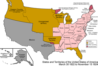
The Territory of Florida was an organized incorporated territory of the United States that existed from March 30, 1822, until March 3, 1845, when it was admitted to the Union as the state of Florida. Originally the Spanish territory of La Florida, and later the provinces of East and West Florida, it was ceded to the United States as part of the 1819 Adams–Onís Treaty. It was governed by the Florida Territorial Council.
A land grant is a grant of land – held by a government to hold until the land it granted to a person. The United States historically gave out numerous land grants to people desiring farmland. The American Industrial Revolution was guided by many supportive acts of legislatures promoting commerce or transportation infrastructure development by private companies, such as the Cumberland Road turnpike, the Lehigh Canal, the Schuylkill Canal, and the many railroads that tied the young United States together.
A land patent is an exclusive land grant made by a sovereign entity with respect to a particular tract of land. To make such a grant "patent", a sovereign must document the land grant, securely sign and seal the document (patent), and openly publish the documents for the public to see. An official land patent is the highest evidence of right, title, and interest to a defined area. It is usually granted by a central, federal, or state government to an individual or to a private company.

The West Florida Controversy refers to two border disputes that involved Spain and the United States in relation to the region known as West Florida over a period of 37 years. The first dispute commenced immediately after Spain received the colonies of West and East Florida from the Kingdom of Great Britain following the American Revolutionary War. Initial disagreements were settled with Pinckney's Treaty of 1795.
The California Land Act of 1851, enacted following the Treaty of Guadalupe Hidalgo and the admission of California as a state in 1850, established a three-member Public Land Commission to determine the validity of prior Spanish and Mexican land grants. It required landowners who claimed title under the Mexican government to file their claim with a commission within two years. Contrary to the Treaty of Guadalupe Hidalgo, which guaranteed full protection of all property rights for Mexican citizens, it placed the burden on landholders to prove their title.
Botiller v. Dominguez, 130 U.S. 238 (1889), was a decision by the United States Supreme Court dealing with the validity of Spanish or Mexican land grants in the Mexican Cession, the region of the present day southwestern United States that was ceded to the U.S. by Mexico in 1848 under the Treaty of Guadalupe Hidalgo.

The Treaty of Vincennes is the name of two separate treaties. One was an agreement between the United States of America and the Miami and their allies, the Wea tribes and the Shawnee, and was signed on June 6, 1803. The purpose of the treaty was to get the native tribes to formally recognize the American ownership of the Vincennes Tract, a parcel of land captured from Great Britain during the American Revolutionary War. The second occurred on August 27, 1804 and was to purchase land from the tribes.
The Cherokee have participated in over forty treaties in the past three hundred years.

The Supreme Court of the United States, under Chief Justice Roger B. Taney (1836–1864), issued several important decisions on the status of aboriginal title in the United States, building on the opinions of aboriginal title in the Marshall Court.

George J. F. Clarke was one of the most prominent and active men of East Florida during the Second Spanish Period. As a friend and trusted advisor of the Spanish governors of the province from 1811 to 1821, he was appointed to several public offices under the colonial regime, including that of surveyor general.
Vicente Sebastian Pintado y Brito was a Spanish cartographer, engineer, military officer and land surveyor of Spanish Louisiana and Spanish West Florida. He is known for conducting surveys of lands for settlers who had requested grants in Louisiana and Florida, as well as the so-called "Pintado plan", a street map of Pensacola drawn in 1812 which included the position and size of the solares designated for construction of the city's church and other public buildings. He lived more than 35 years in the Americas and left a large corpus of work consisting of maps, plats, letters and documents vital to an understanding of the complicated sale of lands in Florida and Louisiana during the period. In 1974, the Library of Congress in Washington, D.C. obtained a donation of the Pintado Collection, a collection of about 1,500 documents now stored in its Division of Manuscripts.


