Related Research Articles
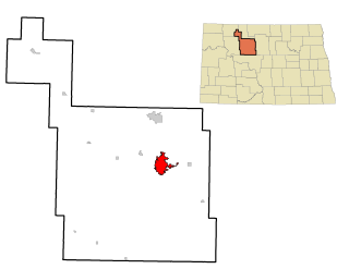
Minot is a city in and the county seat of Ward County, North Dakota, United States, in the state's north-central region. It is most widely known for the Air Force base approximately 15 miles (24 km) north of the city. With a population of 40,888 at the 2010 census, Minot is the state's fourth-largest city and a trading center for a large part of northern North Dakota, southwestern Manitoba, and southeastern Saskatchewan. Founded in 1886 during the construction of James J. Hill's Great Northern Railway, Minot is also known as "Magic City", commemorating its remarkable growth in size over a short time.

The Public Land Survey System (PLSS) is the surveying method developed and used in the United States to plat, or divide, real property for sale and settling. Also known as the Rectangular Survey System, it was created by the Land Ordinance of 1785 to survey land ceded to the United States by the Treaty of Paris in 1783, following the end of the American Revolution. Beginning with the Seven Ranges in present-day Ohio, the PLSS has been used as the primary survey method in the United States. Following the passage of the Northwest Ordinance in 1787, the Surveyor General of the Northwest Territory platted lands in the Northwest Territory. The Surveyor General was later merged with the General Land Office, which later became a part of the U.S. Bureau of Land Management (BLM). Today, the BLM controls the survey, sale, and settling of lands acquired by the United States.
A rest area is a public facility located next to a large thoroughfare such as a motorway, expressway, or highway, at which drivers and passengers can rest, eat, or refuel without exiting onto secondary roads. Other names include: motorway service area (UK), services (UK), travel plaza, rest stop, oasis (US), service area, rest and service area (RSA), resto, service plaza, lay-by, and service centre. Facilities may include park-like areas, fuel stations, public toilets, water fountains, restaurants, and dump and fill stations for caravans.
A township in some states of the United States is a small geographic area.

A shoulder, hard shoulder or breakdown lane, is an emergency stopping lane by the verge of a road or motorway, on the right side in countries which drive on the right, and on the left side in countries which drive on the left. Many wider U.S. freeways have shoulders on both sides of each directional carriageway—in the median, as well as at the outer edges of the road, for additional safety. Shoulders are not intended for use by through traffic, although there are exceptions.

The street layout of Seattle is based on a series of disjointed rectangular street grids. Most of Seattle and King County use a single street grid, oriented on true north. Near the center of the city, various land claims were platted in the 19th century with differently oriented grids, which still survive today. Distinctly oriented grids also exist in some cities annexed by Seattle in the early 20th century, such as Ballard and Georgetown. A small number of streets and roads are exceptions to the grid pattern.

The Phoenix Metropolitan Area – also the Valley of the Sun, the Salt River Valley, or Phoenix Metro – is the largest metropolitan area in the Southwestern United States, centered on the city of Phoenix, that includes much of the central part of Arizona. The United States Office of Management and Budget designates the area as the Phoenix-Mesa-Scottsdale Metropolitan Statistical Area (MSA), defining it as Maricopa and Pinal counties. As of the Census Bureau's 2017 population estimates, Metro Phoenix had 4,737,270 residents, making it the 10th largest metropolitan area in the nation by population. The gross domestic product of the Phoenix Metropolitan Area was $242 billion in 2017, 16th largest amongst metro areas in the United States.
A range road in Canada is a road that runs north–south along a range grid line of the Dominion Land Survey. Range roads are perpendicular to township roads which run east–west along the township grid lines.

Rural electrification is the process of bringing electrical power to rural and remote areas. Rural communities are suffering from colossal market failures as the national grids fall short of their demand for electricity. As of 2017, over 1 billion people worldwide lack household electric power – 14% of the global population. Electrification typically begins in cities and towns and gradually extends to rural areas, however, this process often runs into obstacles in developing nations. Expanding the national grid is expensive and countries consistently lack the capital to grow their current infrastructure. Additionally, amortizing capital costs to reduce the unit cost of each hook-up is harder to do in lightly populated areas. If countries are able to overcome these obstacles and reach nationwide electrification, rural communities will be able to reap considerable amounts of economic and social development.
The Indiana Department of Transportation (INDOT) is responsible for the establishment and classification of a state highway network which includes Interstate Highways, U.S. Highways, and State Roads. There is no rule preventing the same numbering between state roads, U.S. routes, and Interstate highways, although traditionally, INDOT has avoided state road numbers which are the same as those on U.S. routes within the state.
Transportation is essential to trade, which has always been the backbone of the economy of Thunder Bay, Ontario, Canada, beginning with Fort Kaministiquia in 1717. When the area was first settled its many waterways were used by the voyagers and Coureur des bois to trade their goods.
U.S. Route 1 (US 1) is a north–south United States highway which runs along the Eastern Coast of the United States between Key West, Florida and the United States–Canada border near Fort Kent, Maine. In North Carolina, US 1 runs for 174.1 miles (280.2 km) across the central region of the state. The highway enters North Carolina from South Carolina, southwest of Rockingham. US 1 runs northeast, servicing Southern Pines and Sanford in the Sandhills region. US 1 serves the North Carolinian capital of Raleigh and its adjacent suburbs of Cary and Wake Forest. The highway continues north to Henderson, before leaving the state at the Virginia state line, near Wise. It serves as a strategic highway, connecting the North Carolina Sandhills and Research Triangle regions.

A numbered street is a street whose name is an ordinal number, as in Second Street or Tenth Avenue. Such forms are among the most common street names in North America, but also exist in other parts of the world, especially in the Middle East. Numbered streets were first used in Philadelphia and now exist in many major cities and small towns. Grid-based naming systems usually start at 1, and then proceed in numerical order. In the United States, seven out of the top ten most common street names are numbers, with the top three names being "2nd," "3rd," and "1st" respectively.

An electrical grid is an interconnected network for electricity delivery from producers to consumers. Electrical grids vary in size and can cover whole countries or continents. It consists of:
This article describes transportation in the U.S. state of South Dakota.

Metro is a high-capacity transport network serving the Minneapolis-Saint Paul metropolitan area. As of 2020, the system consists of two light rail lines and three bus rapid transit lines operated by Metro Transit. The five lines connect Downtown Minneapolis and St Paul with Bloomington, Minneapolis-St Paul International Airport, Roseville, and Brooklyn Center, with several new lines and extensions in the planning stages.

Transportation in Montana comprises many different forms of travel. Montana shares a long border with Canada, hence international crossings are prevalent in the northern section of the state; there are 13 road crossings and one rail crossing.
The Burkle addressing system is a system of assigning road names and addresses over a large, rural geographical area. It is used in the state of North Dakota for rural addresses to be used for the 911 system as well as mail delivery to rural properties. Because of its use in the 911 system, it is enshrined in North Dakota state law and is used across the state.
References
- ↑ Watts, R.D., R.W. Compton, J.H. McCammon, C.L. Rich, and S.M. Wright. "Distance to the nearest road in the conterminous United States". "1-mile section line road grid"
- ↑ "Emergency Services Communications Systems". North Dakota Century Code No. 57-40.6-10 part d. of April 5, 2001 (PDF). Retrieved 2017-06-07.CS1 maint: discouraged parameter (link)
- ↑ "South Dakota Rural Addressing Procedural Handbook" (PDF). South Dakota 9-1-1 Task Force. September 1992. Retrieved 2017-06-07.