
The College Lands were a tract of land in the Northwest Territory, later Ohio, that the Congress donated for the support of a university. Ohio University became the first college northwest of the Ohio River as a beneficiary of this tract.
The College Lands were a tract of land in the Northwest Territory, later Ohio, that the Congress donated for the support of a university. Ohio University became the first college northwest of the Ohio River as a beneficiary of this tract.
In 1787, Manasseh Cutler, as agent for the Ohio Company of Associates, petitioned Congress to purchase a large tract of land in the Northwest Territory. In this application, he insisted that two townships of land be appropriated for the support of a university. [1] Thus, when the Continental Congress contracted with the company October 23, 1787 [2] included was that “not more than two complete townships should be given perpetually for the purpose of a university; that they be laid off by the purchasers as near the center of the tract as may be and applied to the intended object by the legislature of the state.” Thus, two townships of thirty six square miles each, near the center of the first tract purchased, were reserved for that purpose. [1]

The directors of the Ohio Company selected townships 8 and 9 of the 14th range of the Ohio River survey at a meeting on December 16, 1795 [3] for maintenance of the proposed university. These correspond to the modern civil townships of Alexander and Athens Township Athens County.
Manasseh Cutler drafted legislation that was introduced by his son Ephraim Cutler, [4] and on January 9, 1802, the Territorial Legislature of the Northwest Territory passed “an act establishing a university in the town of Athens.” [5] This act created the American Western University and section eleven of the act vested the two townships with the corporation created to run the university, allowing the trustees to divide and lease the lands for not more than 21 years. American Western University never came to be. One author says it was because no one could be induced to lease wilderness lands for such a short period, [1] while another maintains bad roads, widely separated trustees, and distraction of impending statehood were responsible. [6]
The act chartering American Western University was never repealed. The state had the College Townships appraised in 1803. [7] On February 18, 1804, the Ohio legislature passed another “act establishing a university in the town of Athens.” [8] This act named the university “Ohio University” and authorized the trustees to lease the land “for the term of ninety years, renewable forever, on a yearly rent of six percentum on the amount of valuation” subject to re-evaluation after 35 and 60 years. No leases were taken, as land in adjacent townships could be bought outright for one dollar per acre or less, and no one would risk such re-evaluations. [1] In February 1805, the state directed that leases should run for 99 years, renewable forever, at six percent of appraised valuation. In 1826 the university was permitted to sell lands within the townships, but for leased lands, the rent established in 1805 still prevails. [9]

The Northwest Ordinance, enacted July 13, 1787, was an organic act of the Congress of the Confederation of the United States. It created the Northwest Territory, the new nation's first organized incorporated territory, from lands beyond the Appalachian Mountains, between British North America and the Great Lakes to the north and the Ohio River to the south. The upper Mississippi River formed the territory's western boundary. Pennsylvania was the eastern boundary.

The Northwest Territory, also known as the Old Northwest and formally known as the Territory Northwest of the River Ohio, was formed from unorganized western territory of the United States after the American Revolution. Established in 1787 by the Congress of the Confederation through the Northwest Ordinance, it was the nation's first post-colonial organized incorporated territory.

The Ohio Company of Associates, also known as the Ohio Company, was a land company whose members are today credited with becoming the first non-Native American group to permanently settle west of the Allegheny mountains. In 1788 they established Marietta, Ohio, as the first permanent settlement of the new United States in the newly organized Northwest Territory.
Brigadier-General Rufus Putnam was an American military officer who fought during the French and Indian War and the American Revolutionary War. As an organizer of the Ohio Company of Associates, he was instrumental in the initial colonization by the United States of former Native American, English, and French lands in the Northwest Territory in present-day Ohio following the war. He was known as "Father of the Northwest Territory".

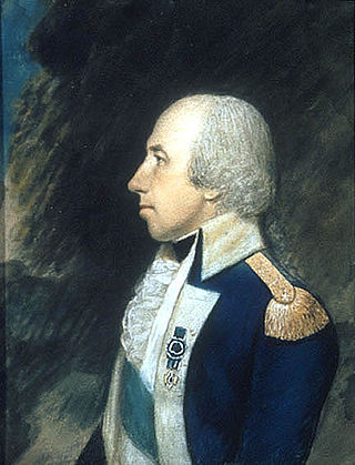
Manasseh Cutler was an American Congregational clergyman involved in the American Revolutionary War. He was influential in the passage of the Northwest Ordinance of 1787 and wrote the section prohibiting slavery in the Northwest Territory. Cutler was also a member of the United States House of Representatives. Cutler is "rightly entitled to be called 'The Father of Ohio University.'"
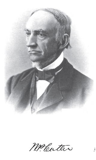
William Parker Cutler was an American railroad executive and politician who served as a U.S. Representative from Ohio for one term from 1861 to 1863.

The Seven Ranges was a land tract in eastern Ohio that was the first tract to be surveyed in what became the Public Land Survey System. The tract is 42 miles (68 km) across the northern edge, 91 miles (146 km) on the western edge, with the south and east sides along the Ohio River. It consists of all of Monroe, Harrison, Belmont and Jefferson, and portions of Carroll, Columbiana, Tuscarawas, Guernsey, Noble, and Washington County.

The Congress Lands was a group of land tracts in Ohio that made land available for sale to members of the general public through land offices in various cities, and through the General Land Office. It consisted of three groups of surveys:
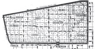
The United States Military District was a land tract in central Ohio that was established by the Congress to compensate veterans of the American Revolutionary War for their service. The tract contains 2,539,110 acres (10,275.4 km2) in Noble, Guernsey, Tuscarawas, Muskingum, Coshocton, Holmes, Licking, Knox, Franklin, Delaware, Morrow, and Marion counties.

The Ephraim Kimberly Grant was a land tract in eastern Ohio that was granted to an American Revolutionary War veteran by Congress late in the 18th century. It was located in the Seven Ranges along the Ohio River.
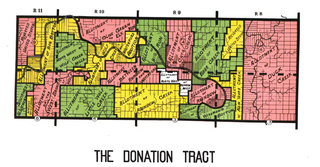
The Donation Tract was a land tract in southern Ohio that was established by the Congress late in the 18th century to buffer Ohio Company lands against local indigenous people. Congress gave 100-acre (0.40 km2) lots to men who settled on the land. This marked the first time that federal land was given without charge to specified settlers, predating the more famous Homestead Act of 1862 by seventy years.
The Congress Lands West of Miami River was a land tract in southwest Ohio that was established by the Congress late in the 18th century. It is located south of the Greenville Treaty Line, east of Indiana, and north of the Great Miami River. The original survey in 1798 contained a triangular shaped slice of land, now located in Indiana, that extended to the Greenville line as it ran from Fort Recovery to opposite the mouth of the Kentucky River.

The Congress Lands East of Scioto River was a land tract in southern Ohio that was established by the Congress late in the 18th century. It is located south of the United States Military District and Refugee Tract, west of the Old Seven Ranges, east of the Virginia Military District and north of the Ohio River, French Grant, and the Ohio Company of Associates.

The Salt Reservations were a collection of land tracts surrounding salt springs in Ohio and some other states that were donated to the states by the federal government early in the 19th century.
The Twelve Mile Square Reservation, also called the Twelve Mile Square Reserve, was a tract of land in Ohio ceded by Indians to the United States of America in the Treaty of Greenville in 1795. This particular area of land immediately surrounding Fort Miami was considered to be of strategic importance by the United States government representatives. It was subsequently surveyed in a manner different from surrounding land, and lots sold, or granted, to settlers.
The Two Mile Square Reservation or Two Mile Square Reserve was a tract of land in Ohio ceded by Native Americans to the United States of America in the Treaty of Greenville in 1795. It was subsequently surveyed in a manner different from surrounding land, and lots sold to settlers.
The Purchase on the Muskingum also called Ohio Company's Second Purchase, was a tract of land in the Northwest Territory, later Ohio, that the Ohio Company of Associates purchased from the United States federal government in 1792.

Zane's Tracts were three parcels of land in the Northwest Territory of the United States, later Ohio, that the federal government granted to Ebenezer Zane late in the 18th century, as compensation for establishing a road with ferry service over several rivers.
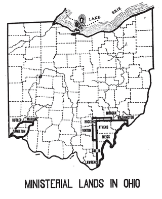
The Ministerial Lands were tracts of land in the Northwest Territory, later Ohio, that the Congress donated for the support of clergy.

Ephraim Cutler was an early Northwest Territory and Ohio political leader and jurist.
Located in: Athens, Ohio | |
| History | |
| Campus | |
| Students | |
| Athletics | |
| Arenas | |
| People | |
| Media |
|
Founded: 1804 | |
| Six-Mile Rectangular System Surveys |
|  |
|---|---|---|
| Five-Mile Rectangular System Surveys | ||
| Indiscriminate Surveys | ||
| metes and bounds Survey | ||
| Land Grants | ||
| Other | ||
Images from Commons | ||