
The Missouri River is a river in the Central and Mountain West regions of the United States. The nation's longest, it rises in the eastern Centennial Mountains of the Bitterroot Range of the Rocky Mountains of southwestern Montana, then flows east and south for 2,341 miles (3,767 km) before entering the Mississippi River north of St. Louis, Missouri. The river drains semi-arid watershed of more than 500,000 square miles (1,300,000 km2), which includes parts of ten U.S. states and two Canadian provinces. Although a tributary of the Mississippi, the Missouri River is slightly longer and carries a comparable volume of water. When combined with the lower Mississippi River, it forms the world's fourth-longest river system.

Big Lake National Wildlife Refuge is an 11,047-acre (45 km2) National Wildlife Refuge located in Mississippi County, Arkansas, managed by the United States Fish and Wildlife Service. It is situated 2 miles (3.2 km) east of Manila, Arkansas, and consists mostly of a shallow lake, swamp, and bottomland hardwood forests. The preservation of habitat for waterfowl in an intensely agricultural region is the primary purpose of the refuge. 6,400 acres (20 km2) of Big Lake was named a National Natural Landmark. 2,144 acres (8 km2) are designated as wilderness.

Marais des Cygnes National Wildlife Refuge (NWR) is located in Linn County, Kansas along the Marais des Cygnes River. The 7,500 acre (30 km2) Refuge was established in 1992 to protect one of the northwesternmost examples of bottomland hardwood forest in the United States as well as the largest contiguous tract of bottomland hardwood forest in Kansas.

The Deep Fork National Wildlife Refuge (DFNWR) is part of the United States system of National Wildlife Refuges, and is a critical resource for wildfowl that migrate along the Central Flyway in Spring and Fall. It is located in Eastern Oklahoma, near the city of Okmulgee. The preserve runs along both banks of the Deep Fork River for about 20 miles (32 km). According to TravelOK, DFNWR receives about 45,000 visitors every year.
The Salt Plains National Wildlife Refuge is part of the United States system of national wildlife refuges. It is located in Alfalfa County in northern Oklahoma, north of Jet, along Great Salt Plains Lake, which is formed by a dam on the Salt Fork of the Arkansas River.

Fort Peck Lake, or Lake Fort Peck, is a major reservoir in Montana, formed by the Fort Peck Dam on the Missouri River. The lake lies in the eastern prairie region of Montana approximately 140 miles (230 km) east of Great Falls and 120 miles (190 km) north of Billings, reaching into portions of six counties.
The Charles M. Russell National Wildlife Refuge is a National Wildlife Refuge in the U.S. state of Montana on the Missouri River. The refuge surrounds Fort Peck Reservoir and is 915,814 acres (3,706.17 km2) in size. It is the second-largest National Wildlife Refuge in the lower 48 states of the United States, and the largest in Montana. Created in 1936, it was originally called the Fort Peck Game Range. It was renamed in 1963 after Montana artist Charles M. Russell, a famous painter of the American West. In 1976, the "range" was made a "refuge".

The Boyer River is a tributary of the Missouri River, 118 miles (190 km) long, in western Iowa in the United States. Most reaches of the river's course have been straightened and channelized.
Bowdoin National Wildlife Refuge is a 15,551-acre (6,293 ha) National Wildlife Refuge (NWR) located in the north-central region of the U.S. state of Montana. The refuge is 7 mi (11 km) northeast of Malta, Montana in the Milk River Valley and is managed by the U.S. Fish and Wildlife Service.

Lewis and Clark Lake is a 31,400 acre (130 km2) reservoir located on the border of the U.S. states of Nebraska and South Dakota on the Missouri River. The lake is approximately 25 miles (40 km) in length with over 90 miles (140 km) of shoreline and a maximum water depth of 45 feet (14 m). The lake is impounded by Gavins Point Dam and is managed by the U.S. Army Corps of Engineers, Omaha District.
The Missouri National Recreational River is a National Recreational River located on the border between Nebraska and South Dakota. The designation was first applied in 1978 to a 59-mile section of the Missouri River between Gavins Point Dam and Ponca State Park. In 1991, an additional 39-mile section between Fort Randall Dam and Niobrara, Nebraska, was added to the designation. These two stretches of the Missouri River are the only parts of the river between Montana and the mouth of the Missouri that remain undammed or unchannelized. The last 20 miles of the Niobrara River and 6 miles of Verdigre Creek were also added in 1991.

Crescent Lake National Wildlife Refuge is located in the U.S. state of Nebraska and includes 45,818 acres (185 km2). The refuge contains the largest protected continuous sand dunes in the U.S. A dozen small lakes and numerous ponds are fed by underground aquifers in areas where the sand dunes are below the water table. Some of the dunes are covered in shrubs and grasses, while others are completely bare. After the end of the Pinedale glaciation, the Holocene glacial retreat exposed the sand dunes that had been deposited in their current location by the vast continental glaciers. This refuge manages the North Platte National Wildlife Refuge and together they form the Crescent Lake National Wildlife Refuge Complex.
Fort Niobrara National Wildlife Refuge is located in the U.S. state of Nebraska and includes 19,131 acres (77.42 km2). The refuge borders the Niobrara National Scenic River on the west and is managed by the U.S. Fish and Wildlife Service. From 1879 to 1906, the Fort Niobrara Military Reservation was located on what later became refuge lands to house a garrison of the U.S. Cavalry. After the fort was closed, the effort to preserve the region as a wildlife refuge culminated in the creation of the refuge on January 11, 1912. The refuge also manages Valentine and John and Louise Seier National Wildlife Refuges as parts of the Fort Niobrara National Wildlife Refuge Complex.

Valentine National Wildlife Refuge is located in the U.S. state of Nebraska and includes 19,131 acres (77.42 km2). The refuge protects a portion of the largest remaining area of tall and mid grass prairie in the United States.
DeSoto National Wildlife Refuge, created in 1958, is located along the banks of the Missouri River in the U.S. states of Iowa and Nebraska. The 8,362-acre (3,384 ha) refuge preserves an area that would have been otherwise lost to cultivation. In 1960, an Army Corps of Engineers channelization project on the Missouri River moved the main river channel in the area to the west. The former river channel became DeSoto Lake, a seven-mile long oxbow lake. As a result, part of the Nebraska portion of the refuge lies on the east side of the Missouri River.

Lake Ilo National Wildlife Refuge (NWR) is located in the U.S. state of North Dakota and is managed from Audubon National Wildlife Refuge by the U.S. Fish and Wildlife Service. The refuge consists of Lake Ilo, surrounding wetlands and some upland range, providing habitat for hundreds of species of birds, and numerous fish and mammal species. An average of over 16 inches (40 cm) of precipitation falls annually, supporting a prairie ecosystem.

The Missouri River Valley outlines the journey of the Missouri River from its headwaters where the Madison, Jefferson and Gallatin Rivers flow together in Montana to its confluence with the Mississippi River in the State of Missouri. At 2,300 miles (3,700 km) long the valley drains one-sixth of the United States, and is the longest river valley on the North American continent. The valley in the Missouri River basin includes river bottoms and floodplains.

The Bill Williams River is a 46.3-mile-long (74.5 km) river in west-central Arizona where it, along with one of its tributaries, the Santa Maria River, form the boundary between Mohave County to the north and La Paz County to the south. It is a major drainage westwards into the Colorado River of the Lower Colorado River Valley south of Hoover Dam and Lake Mead, and the drainage basin covers portions of northwest, and west-central Arizona. The equivalent drainage system paralleling the east–west lower reaches of the Bill Williams is the Gila River, which flows east-to-west across central Arizona, joining the Colorado River in the southwest at Yuma. The confluence of the Bill Williams River with the Colorado is north of Parker, and south of Lake Havasu City.
Bogue Chitto National Wildlife Refuge is located 60 mi (97 km) northeast of New Orleans, Louisiana, U.S., and encompasses 36,000 acres (150 km2) of Pearl River Basin swampland.
The Atchafalaya National Wildlife Refuge is located about 30 miles (48 km) west of Baton Rouge, Louisiana, and one mile (1.6 km) east of Krotz Springs, Louisiana, lies just east of the Atchafalaya River. In 1988 under the administration of Governor Foster the "Atchafalaya Basin Master Plan" was implemented that combined the 11,780-acre (4,770 ha) Sherburne Wildlife Management Area (WMA), the 15,220-acre (6,160 ha) Atchafalaya National Wildlife Refuge, and the 17,000-acre (6,900 ha) U.S. Army Corps of Engineers' Bayou Des Ourses into the Sherburne Complex Wildlife Management Area.


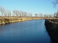 Boyer Chute NWR in November 2005
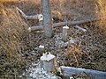 Beaver activity in Boyer Chute NWR
 Road leading to Boyer Chute underwater in June 2011
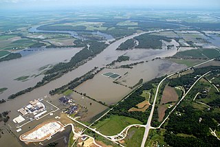
 Waterline and silt left behind by Missouri River floods of 2011 as seen a year later
 Road blocked by debris from 2011 Missouri River floods
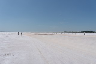
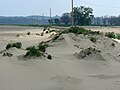 Silt and sand dunes from 2011 Missouri River floods
 Fishing pier destroyed by 2011 Missouri River floods


