Related Research Articles
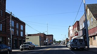
Laurium is a village in Calumet Township, Houghton County in the U.S. state of Michigan, in the center of the Keweenaw Peninsula. The population was 1,977 at the 2010 census.

Hastings is a city and the county seat of Adams County, Nebraska, United States. The population was 24,907 at the 2010 census. It is known as the town where Kool-Aid was invented by Edwin Perkins in 1927, and celebrates that event with the Kool-Aid Days festival every August. Hastings is also known for Fisher Fountain, and during World War II operated the largest Naval Ammunition Depot in the United States.

Central City is a city and the county seat of Merrick County, Nebraska, United States. It is part of the Grand Island, Nebraska Metropolitan Statistical Area. The population was 2,934 at the 2010 census.

Scotts Bluff National Monument is located west of the City of Gering in western Nebraska, United States. This National Park Service site protects over 3,000 acres of historic overland trail remnants, mixed-grass prairie, rugged badlands, towering bluffs and riparian area along the North Platte River. The park boasts over 100,000 annual visitors.

A dugout or dug-out, also known as a pit-house or earth lodge, is a shelter for humans or domesticated animals and livestock based on a hole or depression dug into the ground. Dugouts can be fully recessed into the earth, with a flat roof covered by ground, or dug into a hillside. They can also be semi-recessed, with a constructed wood or sod roof standing out. These structures are one of the most ancient types of human housing known to archaeologists, and the same methods have evolved into modern "earth shelter" technology.
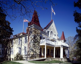
The Clara Barton National Historic Site, which includes the Clara Barton House, was established in 1974 to interpret the life of Clara Barton (1821–1912), an American pioneer teacher, nurse, and humanitarian who was the founder of the American Red Cross. The site is located 2 miles (3.2 km) northwest of Washington D.C. in Glen Echo, Maryland.
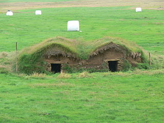
The sod house or soddy was an often used alternative to the log cabin during frontier settlement of the Great Plains of Canada and the United States. Primarily used at first for animal shelters, corrals, and fences, if the prairie lacked standard building materials such as wood or stone, or the poverty of the settlers precluded purchasing standard building materials, sod from thickly-rooted prairie grass was abundant, free, and could be used for house construction. Prairie grass has a much thicker, tougher root structure than a modern lawn.

Fort Omaha, originally known as Sherman Barracks and then Omaha Barracks, is an Indian War-era United States Army supply installation. Located at 5730 North 30th Street, with the entrance at North 30th and Fort Streets in modern-day North Omaha, Nebraska, the facility is primarily occupied by Metropolitan Community College. A Navy Operational Support Center and Marine Corps Reserve unit, along with an Army Reserve unit occupy the periphery of the 82.5 acres (33.4 ha) fort. The government deeded all but four parcels of the land to the community college in 1974.

The Bank of Florence was a wildcat bank located in Florence, Nebraska Territory. It originally operated for three years in the 1850s, and another bank adopted the name and location in 1904. Today the building that housed the bank is the Bank of Florence Museum. It is listed on the National Register of Historic Places, and is the oldest building in Omaha, Nebraska.

The Lincoln Highway in Omaha, Nebraska, runs east–west from near North 183rd Street and West Dodge Road in Omaha, Nebraska, towards North 192nd Street outside of Elkhorn. This section of the Lincoln Highway, one of only 20 miles (32 km) that were paved with brick in Nebraska, is one of the most well-preserved in the country. The roadway was listed on the National Register of Historic Places in 1984. The Lincoln Highway was the first road across the United States, traversing coast-to-coast from Times Square in New York City to Lincoln Park in San Francisco, California.

The James Cant Ranch is a pioneer ranch complex in Grant County in eastern Oregon, United States. The ranch is located on both sides of the John Day River in the John Day Fossil Beds National Monument. The ranch was originally homesteaded by Floyd Officer in 1890. Officer sold the property to James Cant in 1910. Cant increased the size of the property and built a modern ranch complex on the west bank of the river. The National Park Service bought the ranch from the Cant family in 1975, and incorporated the property into the John Day Fossil Beds National Monument. The National Park Service used the main house as a visitor center until 2003. Today, the Cant Ranch complex is preserved as an interpretive site showing visitors an early 20th-century livestock ranch. The James Cant Ranch is listed on the National Register of Historic Places.
The Homecroft Historic District is a national historic district bounded roughly by Madison Avenue, Southview Drive, Orinoco Avenue, and Banta Road in Homecroft, Perry Township, Marion County, Indiana. It was listed on the National Register of Historic Places in 1996.
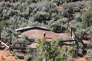
The Hanks' Dugouts are a series of pioneer dwellings in southern Utah, in what is now Capitol Reef National Park. The dugouts were constructed as temporary housing for the Ephraim K. Hanks family, Mormon pioneers who established the now-vanished Floral Ranch on Pleasant Creek in April 1883. The remains of three dugouts and one other structure remain at the site. All above-ground construction has collapsed. The dugouts were abandoned in 1888 when the Hankses built a four-room frame house, although the homestead claim of Hanks' widow claims that a one-room log house was built at the time of settlement. The site includes debris such as ceramic and glass, and pieces of a wagon. The settlement reflects a typical early Mormon homestead of the time.

St. Paul's Methodist Protestant Church, also known as Stone Church, is a church building located south of Culbertson, Nebraska, United States, on Nebraska Highway 17. It was built in 1900 and was added to the National Register in 1979.

This is a list of the National Register of Historic Places listings in Sioux County, Nebraska. It is intended to be a complete list of the properties and districts on the National Register of Historic Places in Sioux County, Nebraska, United States. The locations of National Register properties and districts for which the latitude and longitude coordinates are included below, may be seen in an online map.

Daniel Nelson House and Barn, also known as the Nelson Pioneer Farm and Museum, are historic buildings located north of Oskaloosa, Iowa, United States. Daniel and Margaret Nelson settled here in 1844, a year after this part of Iowa was opened to settlement by the U.S. Government. Their first home was a log structure, non-extant, located northeast of the present house. The present house is a two-story, brick structure with a gable roof. The wooden porches on the front and back of the house date from 1898 to 1900. The large barn measures 61 by 46 feet, and was built in 1856. It is composed of board and batten construction from oak that was milled on the site. It was used largely as a granary, rather than a shelter for farm animals. Three other buildings included in the historic designation include the summer kitchen, woodshed, and a small outdoor privy. The dates of construction for the three frame buildings is unknown. The farm remained in the Nelson family until 1941 when it was abandoned with most of the original furnishings intact. The property was donated to the Mahaska County Historical Society, which now operates it as a museum. Other historic buildings have been moved to this location over the years. It was listed on the National Register of Historic Places in 1974.

The James A. Beattie House, also known as the Beattie Miles House, is a Queen Anne style home built in the Bethany Heights neighborhood of Lincoln, Nebraska, in 1892. The James A. Beattie House is listed on the National Register of Historic Places for its architecture as well as its historical connection with the settlement of the region.

The County Line Bridge spanning the Niobrara River about 17.5 miles (28.2 km) east of Valentine, Nebraska was listed on the National Register of Historic Places in 2018.

The Mays-Boddie House, in Troup County, Georgia, near Mountville, Georgia, was built around 1830. It was listed on the National Register of Historic Places in 1982.

The Missouri Lumber and Mining Company (MLM) was a large timber corporation with headquarters and primary operations in southeast Missouri. The company was formed by Pennsylvania lumbermen who were eager to exploit the untapped timber resources of the Missouri Ozarks to supply lumber, primarily used in construction, to meet the demand of U.S. westward expansion. Its primary operations were centered in Grandin, a company town it built starting c. 1888. The lumber mill there grew to be the largest in the country at the turn of the century and Grandin's population peaked around 2,500 to 3,000. As the timber resources were exhausted, the company had to abandon Grandin around 1910. It continued timber harvesting in other parts of Missouri for another decade. While some of the buildings in Grandin were relocated, many of the remaining buildings were listed on the National Register of Historic Places in 1980 as part of the state's historic preservation plan which considered the MLM a significant technological and economic contributor to Missouri.
References
- 1 2 "National Register Information System". National Register of Historic Places . National Park Service. July 9, 2010.
- ↑ Knispel, Todd H. (December 10, 1999). "National Register of Historic Places Registration Form: Sandford Dugout" (PDF). National Park Service. Archived from the original on July 16, 2012. Retrieved October 20, 2013.
{{cite web}}: CS1 maint: unfit URL (link)
| National Historic Landmark | ||
|---|---|---|
| Historic districts | ||
| Historic properties | ||
| Footnotes | ‡This historic property also has portions in an adjacent county. | |