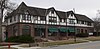
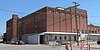
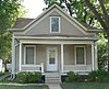
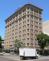
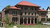
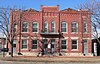
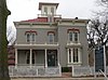
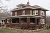
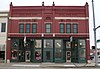
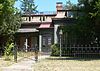
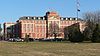
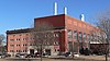
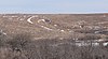
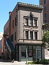
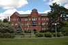
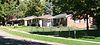
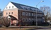
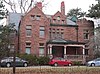
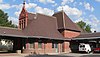
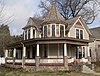
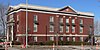
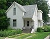
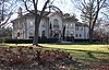
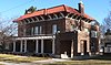
[3] Name on the Register Image Date listed [4] Location City or town Description 1 Agricultural Hall Agricultural Hall December 10, 2010 (# 10001001 Lincoln's State Fairgrounds 40°49′53″N 96°41′34″W / 40.831389°N 96.692778°W / 40.831389; -96.692778 (Agricultural Hall ) Lincoln 2 Antelope Grocery Antelope Grocery March 17, 1988 (# 88000213 2406 J St. 40°48′30″N 96°41′10″W / 40.80821°N 96.6861°W / 40.80821; -96.6861 (Antelope Grocery ) Lincoln 3 Barr Terrace Barr Terrace October 1, 1979 (# 79003688 627-643 S. 11th, and 1044 H St. 40°48′26″N 96°42′21″W / 40.80729°N 96.70595°W / 40.80729; -96.70595 (Barr Terrace ) Lincoln Part of the Nineteenth Century Terrace Houses Thematic Resource (TR) 4 Beatrice Creamery Company Lincoln Plant Beatrice Creamery Company Lincoln Plant March 12, 2012 (# 12000104 726 L St. 40°48′39″N 96°42′39″W / 40.810935°N 96.710717°W / 40.810935; -96.710717 (Beatrice Creamery Company Lincoln Plant ) Lincoln 5 James A. Beattie House James A. Beattie House December 4, 1990 (# 90001773 6706 Colby St. 40°50′00″N 96°37′43″W / 40.83339°N 96.62875°W / 40.83339; -96.62875 (James A. Beattie House ) Lincoln 6 Jasper Newton Bell House Jasper Newton Bell House June 21, 1984 (# 84002483 2212 Sheldon St. 40°49′38″N 96°41′22″W / 40.82736°N 96.68953°W / 40.82736; -96.68953 (Jasper Newton Bell House ) Lincoln 7 Boulevards Historic District Boulevards Historic District December 10, 2008 (# 08001180 Roughly bounded by South St., Calvert and High Sts., S. 22nd and S. 24th Sts., Rock Island Trail, and Sheridan Boulevard 40°47′04″N 96°41′05″W / 40.784444°N 96.684722°W / 40.784444; -96.684722 (Boulevards Historic District ) Lincoln 8 Guy A. Brown House Guy A. Brown House March 5, 1998 (# 98000195 219-221 S. 27th St. 40°48′42″N 96°40′58″W / 40.81174°N 96.68264°W / 40.81174; -96.68264 (Guy A. Brown House ) Lincoln 9 Brownbilt Residential Historic District Brownbilt Residential Historic District August 29, 2012 (# 12000565 Bounded by A, D, S. 37th to S. 40th Sts. 40°48′03″N 96°39′56″W / 40.800767°N 96.665656°W / 40.800767; -96.665656 (Brownbilt Residential Historic District ) Lincoln 10 Burckhardt House Burckhardt House June 25, 1999 (# 99000746 1236 Washington St. 40°47′54″N 96°42′11″W / 40.79833°N 96.70317°W / 40.79833; -96.70317 (Burckhardt House ) Lincoln Part of the African American Historic and Architectural Resources in Lincoln, Nebraska MPS 11 Edgar A. Burnett House Edgar A. Burnett House July 12, 2006 (# 06000609 3256 Holdrege St. 40°49′42″N 96°40′28″W / 40.828333°N 96.67444°W / 40.828333; -96.67444 (Edgar A. Burnett House ) Lincoln 12 Burr Block Burr Block May 18, 1979 (# 79001448 1206 O St. 40°48′50″N 96°42′14″W / 40.81389°N 96.70381°W / 40.81389; -96.70381 (Burr Block ) Lincoln 13 James D. Calhoun House James D. Calhoun House April 26, 2002 (# 02000411 1130 Plum St. 40°47′34″N 96°42′17″W / 40.79286°N 96.70481°W / 40.79286; -96.70481 (James D. Calhoun House ) Lincoln 14 William H. Charlton House William H. Charlton House January 25, 1997 (# 96001614 17705 S. 12th Street [5] 40°38′13″N 96°42′22″W / 40.63702°N 96.70617°W / 40.63702; -96.70617 (William H. Charlton House ) Roca 15 Chicago, Burlington & Quincy Steam Locomotive No. 710 Chicago, Burlington & Quincy Steam Locomotive No. 710 June 20, 1997 (# 97000609 Near the junction of 7th and Q Sts. 40°48′57″N 96°42′42″W / 40.81589°N 96.71164°W / 40.81589; -96.71164 (Chicago, Burlington & Quincy Steam Locomotive No. 710 ) Lincoln 16 Christian Record Building Christian Record Building December 1, 1986 (# 86003384 3705 S. 48th St. 40°46′33″N 96°39′16″W / 40.77581°N 96.65444°W / 40.77581; -96.65444 (Christian Record Building ) Lincoln 17 City Hall City Hall October 15, 1969 (# 69000132 920 O St. 40°48′50″N 96°42′28″W / 40.81392°N 96.70777°W / 40.81392; -96.70777 (City Hall ) Lincoln 18 College View Public Library College View Public Library June 28, 1984 (# 84002486 3800 S. 48th St. 40°46′23″N 96°39′13″W / 40.77317°N 96.65369°W / 40.77317; -96.65369 (College View Public Library ) Lincoln 19 Eastridge Historic District Eastridge Historic District July 31, 2017 (# 100001394 Generally bounded by L to A Sts., 56th & Cotner Blvd. to Sunrise & Mulder Drs. 40°48′19″N 96°38′24″W / 40.805301°N 96.640023°W / 40.805301; -96.640023 (Eastridge Historic District ) Lincoln 478 contributing buildings. 20 Eddy-Taylor House Eddy-Taylor House July 21, 1983 (# 83001098 435 N. 25th 40°49′03″N 96°41′08″W / 40.81762°N 96.68544°W / 40.81762; -96.68544 (Eddy-Taylor House ) Lincoln 21 Fairview Fairview October 15, 1966 (# 66000947 4900 Sumner St. 40°47′45″N 96°39′06″W / 40.79581°N 96.65163°W / 40.79581; -96.65163 (Fairview ) Lincoln 22 Federal Trust Building Federal Trust Building April 25, 2002 (# 02000409 134 S. 13th St. 40°48′46″N 96°42′08″W / 40.81269°N 96.70236°W / 40.81269; -96.70236 (Federal Trust Building ) Lincoln 23 William H. Ferguson House William H. Ferguson House November 29, 1972 (# 72000755 700 S. 16th St. 40°48′24″N 96°41′52″W / 40.80661°N 96.69786°W / 40.80661; -96.69786 (William H. Ferguson House ) Lincoln 24 First National Bank Building First National Bank Building March 5, 1998 (# 98000190 1001 O St. 40°48′48″N 96°42′24″W / 40.81335°N 96.70679°W / 40.81335; -96.70679 (First National Bank Building ) Lincoln 25 First State Bank of Bethany First State Bank of Bethany July 24, 1986 (# 86001936 1551 N. Cotner Boulevard 40°49′44″N 96°37′50″W / 40.82883°N 96.63069°W / 40.82883; -96.63069 (First State Bank of Bethany ) Lincoln 26 Frank E. and Emma A. Gillen House Frank E. and Emma A. Gillen House March 5, 1998 (# 98000188 2245 A St. 40°47′55″N 96°41′17″W / 40.79869°N 96.68819°W / 40.79869; -96.68819 (Frank E. and Emma A. Gillen House ) Lincoln 27 Gold and Company Store Building Gold and Company Store Building October 19, 1982 (# 82000609 1033 O St. 40°48′48″N 96°42′21″W / 40.81322°N 96.70597°W / 40.81322; -96.70597 (Gold and Company Store Building ) Lincoln 28 Government Square Government Square April 15, 2004 (# 04000303 N. 9th to N. 10th St., O to P Sts. 40°48′51″N 96°42′28″W / 40.81414°N 96.70773°W / 40.81414; -96.70773 (Government Square ) Lincoln 29 Greek Row Historic District Greek Row Historic District June 25, 1997 (# 97000611 Roughly, R St. from 14th to 17th Sts. and 16th St. from R toVine Sts. 40°49′06″N 96°41′55″W / 40.818333°N 96.698611°W / 40.818333; -96.698611 (Greek Row Historic District ) Lincoln 30 Harris House Harris House September 2, 1982 (# 82003194 1630 K St. 40°48′34″N 96°41′51″W / 40.80942°N 96.69739°W / 40.80942; -96.69739 (Harris House ) Lincoln 31 Hayward School Hayward School August 23, 1985 (# 85001795 1215 N. 9th 40°49′34″N 96°42′31″W / 40.82616°N 96.70861°W / 40.82616; -96.70861 (Hayward School ) Lincoln 32 Helmer-Winnett-White Flats Helmer-Winnett-White Flats October 1, 1979 (# 79003690 1022-1028 K St. 40°48′34″N 96°42′22″W / 40.80939°N 96.70619°W / 40.80939; -96.70619 (Helmer-Winnett-White Flats ) Lincoln Part of the Nineteenth Century Terrace Houses TR 33 Herter Farmstead Herter Farmstead July 24, 2000 (# 00000835 4949 S. 148th [6] 40°45′51″N 96°31′16″W / 40.764167°N 96.521111°W / 40.764167; -96.521111 (Herter Farmstead ) Walton 34 W.F. Hitchcock House W.F. Hitchcock House December 5, 2002 (# 02001482 2733 Sheridan Boulevard 40°47′11″N 96°40′54″W / 40.7865°N 96.6816°W / 40.7865; -96.6816 (W.F. Hitchcock House ) Lincoln Colonial Revival-styled house built in 1922 35 Hotel Capital Hotel Capital December 5, 1983 (# 83003994 139 N. 11th St. 40°48′52″N 96°42′21″W / 40.81446°N 96.70587°W / 40.81446; -96.70587 (Hotel Capital ) Lincoln 36 Aeneas Yates-Charles Hurlbut House Aeneas Yates-Charles Hurlbut House September 17, 1999 (# 99001167 720 S. 16th St. 40°48′22″N 96°41′52″W / 40.80611°N 96.69783°W / 40.80611; -96.69783 (Aeneas Yates-Charles Hurlbut House ) Lincoln Now occupied by Alpha Delta Pi sorority [7] 37 Iowa-Nebraska Light and Power Company Plant Iowa-Nebraska Light and Power Company Plant March 6, 2023 (# 100008676 440 South 8th St. 40°48′34″N 96°42′36″W / 40.8094°N 96.7099°W / 40.8094; -96.7099 (Iowa-Nebraska Light and Power Company Plant ) Lincoln 38 Thomas P. Kennard House Thomas P. Kennard House April 16, 1969 (# 69000134 1627 H St. 40°48′24″N 96°41′51″W / 40.80663°N 96.69741°W / 40.80663; -96.69741 (Thomas P. Kennard House ) Lincoln 39 Theodore A. Kiesselbach House Theodore A. Kiesselbach House July 1, 1994 (# 94000651 3232 Holdrege St. 40°49′42″N 96°40′30″W / 40.82828°N 96.67494°W / 40.82828; -96.67494 (Theodore A. Kiesselbach House ) Lincoln 40 Rose Kirkwood Brothel Rose Kirkwood Brothel August 28, 2012 (# 12000566 124 S. 9th St. 40°48′47″N 96°42′29″W / 40.812997°N 96.708024°W / 40.812997; -96.708024 (Rose Kirkwood Brothel ) Lincoln 41 Amel H. Koop House Amel H. Koop House December 2, 2014 (# 14001014 1401 S. 15th St. 40°47′56″N 96°42′00″W / 40.798960°N 96.699979°W / 40.798960; -96.699979 (Amel H. Koop House ) Lincoln 42 Lancaster Block Lancaster Block April 12, 1989 (# 89000245 6201-6205 Havelock Ave. 40°51′25″N 96°38′08″W / 40.85686°N 96.63556°W / 40.85686; -96.63556 (Lancaster Block ) Lincoln 43 Lewis-Syford House Lewis-Syford House February 18, 1971 (# 71000486 700 N. 16th St. [8] 40°49′13″N 96°41′52″W / 40.82014°N 96.69775°W / 40.82014; -96.69775 (Lewis-Syford House ) Lincoln 44 Lincoln Army Air Field Regimental Chapel Lincoln Army Air Field Regimental Chapel June 17, 1993 (# 93000535 4601 NW. 48th St. 40°51′38″N 96°47′15″W / 40.86049°N 96.78761°W / 40.86049; -96.78761 (Lincoln Army Air Field Regimental Chapel ) Lincoln 45 Lincoln Haymarket Historic District Lincoln Haymarket Historic District July 8, 2014 (# 14000288 Generally 7th to 9th & N to R Sts. 40°48′53″N 96°42′36″W / 40.8148°N 96.7100°W / 40.8148; -96.7100 (Lincoln Haymarket Historic District ) Lincoln (Develop this topic within Haymarket District (Lincoln, Nebraska) ) 46 Lincoln Liberty Life Insurance Building Lincoln Liberty Life Insurance Building January 19, 1988 (# 87002299 113 N. 11th St. 40°48′50″N 96°42′21″W / 40.81386°N 96.70586°W / 40.81386; -96.70586 (Lincoln Liberty Life Insurance Building ) Lincoln 47 Lincoln Veterans Administration Hospital Historic District Lincoln Veterans Administration Hospital Historic District September 10, 2012 (# 12000785 600 S. 70th St. 40°48′32″N 96°37′21″W / 40.808888°N 96.622526°W / 40.808888; -96.622526 (Lincoln Veterans Administration Hospital Historic District ) Lincoln Part of the United States Second Generation Veterans Hospitals MPS 48 Lincoln YWCA Building Lincoln YWCA Building June 21, 1984 (# 84002490 1432 N St. 40°48′46″N 96°42′01″W / 40.81267°N 96.70025°W / 40.81267; -96.70025 (Lincoln YWCA Building ) Lincoln 49 Lyman Terrace Lyman Terrace October 1, 1979 (# 79003689 1111-1119 H St. 40°48′24″N 96°42′18″W / 40.80671°N 96.70501°W / 40.80671; -96.70501 (Lyman Terrace ) Lincoln Part of the Nineteenth Century Terrace Houses TR 50 Masonic Temple Masonic Temple August 5, 2005 (# 05000792 1635 L St. 40°48′36″N 96°41′50″W / 40.80993°N 96.69727°W / 40.80993; -96.69727 (Masonic Temple ) Lincoln 51 McWilliams House McWilliams House June 25, 1999 (# 99000748 1723 N. 29th St. 40°49′49″N 96°40′48″W / 40.830339°N 96.679927°W / 40.830339; -96.679927 (McWilliams House ) Lincoln Part of the African American Historic and Architectural Resources in Lincoln, Nebraska MPS 52 Mount Emerald and Capitol Additions Historic Residential District Mount Emerald and Capitol Additions Historic Residential District June 5, 1980 (# 80002453 Roughly bounded by A, G, 17th, and 22nd Sts. 40°48′08″N 96°41′34″W / 40.802222°N 96.692778°W / 40.802222; -96.692778 (Mount Emerald and Capitol Additions Historic Residential District ) Lincoln 53 Municipal Lighting and Waterworks Plant Municipal Lighting and Waterworks Plant July 24, 1986 (# 86001938 2901 A St. 40°47′55″N 96°40′41″W / 40.7986°N 96.6781°W / 40.7986; -96.6781 (Municipal Lighting and Waterworks Plant ) Lincoln 54 William L. and Sydney V. Murphy House William L. and Sydney V. Murphy House November 4, 1994 (# 94001280 2525 N St. 40°48′44″N 96°41′04″W / 40.81213°N 96.68455°W / 40.81213; -96.68455 (William L. and Sydney V. Murphy House ) Lincoln 55 Nebraska City to Fort Kearny Cutoff Ruts at Spring Creek Prairie Nebraska City to Fort Kearny Cutoff Ruts at Spring Creek Prairie July 11, 2002 (# 02000771 11700 SW. 100th St. 40°41′30″N 96°50′54″W / 40.69167°N 96.84833°W / 40.69167; -96.84833 (Nebraska City to Fort Kearny Cutoff Ruts at Spring Creek Prairie ) Denton 56 Nebraska Governor's Mansion Nebraska Governor's Mansion March 12, 2008 (# 08000173 1425 H St. 40°48′23″N 96°42′02″W / 40.80644°N 96.70047°W / 40.80644; -96.70047 (Nebraska Governor's Mansion ) Lincoln 57 Nebraska State Capitol Nebraska State Capitol October 16, 1970 (# 70000372 1445 K St. 40°48′29″N 96°41′57″W / 40.808056°N 96.699167°W / 40.808056; -96.699167 (Nebraska State Capitol ) Lincoln 58 Nebraska State Historical Society Building Nebraska State Historical Society Building August 21, 2003 (# 03000797 1500 R St. 40°49′02″N 96°41′59″W / 40.81722°N 96.69965°W / 40.81722; -96.69965 (Nebraska State Historical Society Building ) Lincoln 59 Nebraska Telephone Company Building Nebraska Telephone Company Building November 16, 1978 (# 78001703 128-130 S. 13th St. 40°48′47″N 96°42′09″W / 40.81298°N 96.70239°W / 40.81298; -96.70239 (Nebraska Telephone Company Building ) Lincoln 60 Nine-Mile Prairie Nine-Mile Prairie July 30, 1986 (# 86002089 Northwest of Huskerville 40°52′01″N 96°48′54″W / 40.866944°N 96.815°W / 40.866944; -96.815 (Nine-Mile Prairie ) Lincoln 61 Old Main, Nebraska Wesleyan University Old Main, Nebraska Wesleyan University May 21, 1975 (# 75001097 50th and St. Paul Sts. 40°50′20″N 96°38′58″W / 40.838889°N 96.649444°W / 40.838889; -96.649444 (Old Main, Nebraska Wesleyan University ) Lincoln 62 Old University Library Old University Library August 6, 1975 (# 75001098 11th and R Sts. 40°49′02″N 96°42′22″W / 40.81731°N 96.70611°W / 40.81731; -96.70611 (Old University Library ) Lincoln 63 Palisade and Regent Apartments Palisade and Regent Apartments March 5, 1998 (# 98000191 1035 S. 17th St. and 1626 D St. 40°48′10″N 96°41′50″W / 40.80276°N 96.69725°W / 40.80276; -96.69725 (Palisade and Regent Apartments ) Lincoln 64 Park Hill Park Hill September 3, 2010 (# 10000628 1913 S. 41st St. 40°47′35″N 96°39′46″W / 40.79292°N 96.66267°W / 40.79292; -96.66267 (Park Hill ) Lincoln 65 Park Manor Residential Historic District Park Manor Residential Historic District September 4, 2013 (# 13000675 Bounded by A, South, 56th & 70th Sts. 40°47′44″N 96°38′04″W / 40.795683°N 96.634369°W / 40.795683; -96.634369 (Park Manor Residential Historic District ) Lincoln 66 Peter Peterson Farmstead Peter Peterson Farmstead February 11, 1980 (# 80002456 Address Restricted Waverly 67 Phi Delta Theta Fraternity House Phi Delta Theta Fraternity House May 28, 1986 (# 86001183 1545 R St. 40°49′00″N 96°41′55″W / 40.81662°N 96.69848°W / 40.81662; -96.69848 (Phi Delta Theta Fraternity House ) Lincoln 68 Phi Kappa Tau Fraternity House Phi Kappa Tau Fraternity House November 25, 2005 (# 05001329 5305 Huntington Ave. 40°50′13″N 96°38′48″W / 40.83708°N 96.64678°W / 40.83708; -96.64678 (Phi Kappa Tau Fraternity House ) Lincoln 69 R.O. Phillips House R.O. Phillips House November 29, 1979 (# 79001449 1845 D St 40°48′08″N 96°41′40″W / 40.80215°N 96.69442°W / 40.80215; -96.69442 (R.O. Phillips House ) Lincoln 70 Pioneers Park Pioneers Park June 17, 1993 (# 93000538 Junction of W. Van Dorn and Coddington Sts. 40°46′39″N 96°45′57″W / 40.7775°N 96.765833°W / 40.7775; -96.765833 (Pioneers Park ) Lincoln 71 President and Ambassador Apartments President and Ambassador Apartments December 10, 1993 (# 93001401 1330 and 1340 Lincoln Mall 40°48′30″N 96°42′06″W / 40.80833°N 96.70161°W / 40.80833; -96.70161 (President and Ambassador Apartments ) Lincoln 72 Quinn Chapel African Methodist Episcopal Church and Parsonage Quinn Chapel African Methodist Episcopal Church and Parsonage June 25, 1999 (# 99000749 1225 S. 9th St. 40°48′04″N 96°42′32″W / 40.80114°N 96.70889°W / 40.80114; -96.70889 (Quinn Chapel African Methodist Episcopal Church and Parsonage ) Lincoln Part of the African American Historic and Architectural Resources in Lincoln, Nebraska MPS 73 Retzlaff Farmstead Retzlaff Farmstead May 31, 1979 (# 79001450 Address Restricted Lincoln 74 Robbers' Cave Robbers' Cave March 13, 2020 (# 100005055 925 Robbers Cave Rd. 40°46′49″N 96°42′27″W / 40.7802°N 96.7074°W / 40.7802; -96.7074 (Robbers' Cave ) Lincoln 75 Rock Island Depot Rock Island Depot September 3, 1971 (# 71000487 1944 O St. 40°48′51″N 96°41′34″W / 40.81426°N 96.69285°W / 40.81426; -96.69285 (Rock Island Depot ) Lincoln 76 Nimrod Ross House Nimrod Ross House June 25, 1999 (# 99000747 445 S. 30th St. 40°48′28″N 96°40′37″W / 40.807778°N 96.676944°W / 40.807778; -96.676944 (Nimrod Ross House ) Lincoln Part of the African American Historic and Architectural Resources in Lincoln, Nebraska MPS 77 Royer-Williams House Royer-Williams House June 14, 1982 (# 82003195 407 N. 26th St. 40°49′02″N 96°41′02″W / 40.81714°N 96.68401°W / 40.81714; -96.68401 (Royer-Williams House ) Lincoln Grace, Sarah, Leslie and Katie's little castle since July 29th, 2023 78 Ryons-Alexander House Ryons-Alexander House July 8, 1982 (# 82003196 1835 Ryons St. 40°47′26″N 96°41′41″W / 40.79061°N 96.69467°W / 40.79061; -96.69467 (Ryons-Alexander House ) Lincoln 79 St. Charles Apartments St. Charles Apartments September 12, 1985 (# 85002138 4717 Baldwin Ave. 40°50′17″N 96°39′17″W / 40.83806°N 96.65472°W / 40.83806; -96.65472 (St. Charles Apartments ) Lincoln 80 Schrader Archeological Site Upload image January 21, 1974 (# 74002290 9 miles (14 km) south of Lincoln [9] Roca Village along Salt Creek named for the landowner. Excavated by E.E. Blackman in 1901; [9] by him denominated the "Roca Site" [10] 81 Scottish Rite Temple Scottish Rite Temple December 1, 1986 (# 86003359 332 Centennial Mall, S. 40°48′38″N 96°41′58″W / 40.81061°N 96.69931°W / 40.81061; -96.69931 (Scottish Rite Temple ) Lincoln 82 Sheldon Memorial Art Gallery Sheldon Memorial Art Gallery September 3, 2013 (# 13000676 12th & R Sts., University of Nebraska–Lincoln 40°49′03″N 96°42′16″W / 40.8175°N 96.704444°W / 40.8175; -96.704444 (Sheldon Memorial Art Gallery ) Lincoln 83 Sky Park Manor Sky Park Manor August 8, 2016 (# 16000515 1301 Lincoln Mall 40°48′29″N 96°42′08″W / 40.808084°N 96.702304°W / 40.808084; -96.702304 (Sky Park Manor ) Lincoln 84 South Bottoms Historic District South Bottoms Historic District July 17, 1986 (# 86001717 Roughly bounded by M and J and H and G Sts., 2nd and 9th Sts., and W. B Sts., and Salt Creek 40°48′16″N 96°43′02″W / 40.804444°N 96.717222°W / 40.804444; -96.717222 (South Bottoms Historic District ) Lincoln 85 Frank M. Spalding House Frank M. Spalding House March 25, 1999 (# 99000386 2221 Sheridan Boulevard 40°47′25″N 96°41′07″W / 40.79028°N 96.68536°W / 40.79028; -96.68536 (Frank M. Spalding House ) Lincoln 86 Speidel Barn Speidel Barn June 26, 2023 (# 100009090 7800 South 40th St. 40°43′57″N 96°39′48″W / 40.7324°N 96.6632°W / 40.7324; -96.6632 (Speidel Barn ) Lincoln 87 R.O. Stake House R.O. Stake House April 27, 2005 (# 05000357 145 S. 28th St. 40°48′45″N 96°40′53″W / 40.81245°N 96.68127°W / 40.81245; -96.68127 (R.O. Stake House ) Lincoln 88 State Arsenal State Arsenal September 17, 1981 (# 81000372 17th and Court Sts. 40°49′45″N 96°41′49″W / 40.82922°N 96.69696°W / 40.82922; -96.69696 (State Arsenal ) Lincoln 89 Strode Building Strode Building November 9, 2020 (# 100005770 1600-1608 O St. 40°48′49″N 96°41′52″W / 40.8137°N 96.6978°W / 40.8137; -96.6978 (Strode Building ) Lincoln 90 Stuart Building Stuart Building December 23, 2003 (# 03001341 13th and P Sts. 40°48′52″N 96°42′08″W / 40.81442°N 96.70231°W / 40.81442; -96.70231 (Stuart Building ) Lincoln 91 Temple of Congregation B'nai Jeshurun Temple of Congregation B'nai Jeshurun June 25, 1982 (# 82003197 2061 S. 20th Street [11] 40°47′31″N 96°41′32″W / 40.79192°N 96.69231°W / 40.79192; -96.69231 (Temple of Congregation B'nai Jeshurun ) Lincoln 92 Terminal Building Terminal Building December 29, 1986 (# 86003527 947 O St. 40°48′48″N 96°42′26″W / 40.81335°N 96.70732°W / 40.81335; -96.70732 (Terminal Building ) Lincoln 93 John M. Thayer House John M. Thayer House December 5, 2002 (# 02001479 1901 Prospect St. 40°47′41″N 96°41′38″W / 40.79472°N 96.69378°W / 40.79472; -96.69378 (John M. Thayer House ) Lincoln 94 Tifereth Israel Synagogue Tifereth Israel Synagogue May 9, 1985 (# 85000958 344 S. 18th St. 40°48′38″N 96°41′42″W / 40.81044°N 96.695°W / 40.81044; -96.695 (Tifereth Israel Synagogue ) Lincoln Now Tifereth Place Apts. [12] 95 William H. Tyler House William H. Tyler House April 6, 1978 (# 78001704 808 D St. 40°48′10″N 96°42′35″W / 40.80281°N 96.709722°W / 40.80281; -96.709722 (William H. Tyler House ) Lincoln 96 University Place Historic Residential District University Place Historic Residential District February 7, 2003 (# 03000069 Roughly Walker Ave., 51st-54th Sts., Leighton Ave., and 49th-53rd Sts. 40°50′09″N 96°39′06″W / 40.835833°N 96.651667°W / 40.835833; -96.651667 (University Place Historic Residential District ) Lincoln 97 Veith Building Veith Building September 18, 1980 (# 80002454 816 P St. 40°48′54″N 96°42′34″W / 40.81492°N 96.7094°W / 40.81492; -96.7094 (Veith Building ) Lincoln 98 Albert Watkins House Albert Watkins House April 3, 1989 (# 89000244 920 D St. 40°48′10″N 96°42′28″W / 40.8028°N 96.7079°W / 40.8028; -96.7079 (Albert Watkins House ) Lincoln 99 Wesleyan Hospital and Nurses Training School Wesleyan Hospital and Nurses Training School November 12, 2015 (# 15000794 2742 N. 48th St. 40°50′25″N 96°39′12″W / 40.840167°N 96.653442°W / 40.840167; -96.653442 (Wesleyan Hospital and Nurses Training School ) Lincoln 100 Whitehall Whitehall October 29, 1982 (# 82000610 5903 Walker 40°50′10″N 96°38′24″W / 40.83622°N 96.63992°W / 40.83622; -96.63992 (Whitehall ) Lincoln 101 Woods Brothers Building Woods Brothers Building September 18, 1980 (# 80002455 132 S. 13th St. 40°48′46″N 96°42′09″W / 40.81291°N 96.70237°W / 40.81291; -96.70237 (Woods Brothers Building ) Lincoln 102 Frank and Nelle Cochrane Woods House Frank and Nelle Cochrane Woods House June 30, 1995 (# 95000793 2501 Sheridan Boulevard 40°47′14″N 96°41′04″W / 40.78736°N 96.68444°W / 40.78736; -96.68444 (Frank and Nelle Cochrane Woods House ) Lincoln 103 Woodsshire Residential Historic District Woodsshire Residential Historic District March 29, 2011 (# 11000147 Bounded by High and Calvert Sts., South 17th to South 20th Sts. 40°46′45″N 96°41′41″W / 40.779167°N 96.694722°W / 40.779167; -96.694722 (Woodsshire Residential Historic District ) Lincoln 104 Wyuka Cemetery Wyuka Cemetery July 19, 1982 (# 82003198 3600 O St. 40°49′01″N 96°39′54″W / 40.816944°N 96.665°W / 40.816944; -96.665 (Wyuka Cemetery ) Lincoln 105 Yates-Martin House Yates-Martin House August 10, 2022 (# 100007939 2109 South 24th St. 40°47′29″N 96°41′14″W / 40.7915°N 96.6873°W / 40.7915; -96.6873 (Yates-Martin House ) Lincoln 106 John H. and Christina Yost House John H. and Christina Yost House April 26, 2002 (# 02000410 1900 S. 25th St. 40°47′36″N 96°41′08″W / 40.79328°N 96.6856°W / 40.79328; -96.6856 (John H. and Christina Yost House ) Lincoln 107 Arthur C. Ziemer House Arthur C. Ziemer House November 23, 1977 (# 77000832 2030 Euclid Ave. 40°47′40″N 96°41′28″W / 40.79431°N 96.691111°W / 40.79431; -96.691111 (Arthur C. Ziemer House ) Lincoln