The first West Virginia state park, Droop Mountain Battlefield, was acquired in 1928 and dedicated in 1929; and the newest state parks, Elk River Trail and Summersville Lake, were established in 2019 and 2023, respectively. Four parks that later joined the state park system were established prior to Droop Mountain, the earliest being the Point Pleasant Monument (now Tu-Endie-Wei) in 1901. There are seven former West Virginia state parks: one state park was transferred to the National Park Service (NPS), one to the West Virginia Division of Culture and History, one to the West Virginia Division of Highways, and one to a municipality, and three have ceased to exist entirely.
This list provides an overview of West Virginia state parks and a brief history of their development and governance since the first state park was dedicated in 1929. State parks range in size from 4 acres (2ha) to 10,100 acres (4,087ha). Of the 39 state parks governed by the WVDNR Parks and Recreation Section, 10 are lodge/resort state parks, 25 are cabin, camping, and day-use state parks, and three are rail trails.
Overview
West Virginia's state parks are governed by the West Virginia Division of Natural Resources (WVDNR) Parks and Recreation Section, which is under the jurisdiction of the West Virginia Department of Commerce.[9][10][11] The WVDNR Parks and Recreation Section manages a system of 39 state parks (including three rail trails) and eight state forests totaling around 164,000 acres (66,368ha) of land, which consists of nearly 12,000 acres (4,856ha) of developed lands with recreational facilities and nearly 152,000 acres (61,512ha) of undeveloped land.[12][c] In total, West Virginia has over 1.6million acres (6,475km2) of state and federal protected lands.[13] State parks and forests also feature more than 1,400 miles (2,253km) of hiking trails across 45 areas.[12]
As of 2016[update], the WVDNR Parks and Recreation Section directly employed more than 400 full-time and around 1,000 seasonal and summer employees who serviced approximately 7.1million visitors (65% state residents and 35% out-of-state).[12][21] WVDNR Parks and Recreation Section personnel maintain over 2.5million square feet (232,258m2) of indoor space in more than 1,500 buildings in West Virginia state parks and forests, which have an inventory of 818 lodge rooms, 369 cabins, 1,522 campsites, 144 picnic shelters, and 549 playground units.[12] The total economic impact of West Virginia state parks and forests annually is between US$160.5million and $189.5 million and for every $1 of general tax revenue provided to state parks and forests in 2016, $13.15 on average was generated in fresh revenue for the state.[21] In 2016, visitors to state parks and forests spent $226.5million throughout the state, of which 46% ($103.6million) was spent by out-of-state visitors.[21] The total economic activity attributed to visitors of state parks and forests in 2016 totaled between $213.4million and $248.7million.[21]
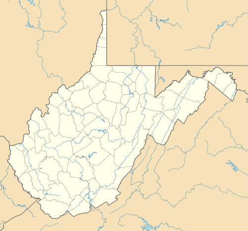
West Virginia state parks map with 39 clickable links
History
West Virginia's lumber and mineral exploitation had caused tremendous damage to much of its natural environment by the early 20thcentury.[18] The state recognized the need to designate and protect lands worthy of conservation, and in 1925 the West Virginia Legislature established the West Virginia State Forest, Park and Conservation Commission to assess the state's opportunities and needs for forests, parks, game preserves, and recreational areas.[18][22] West Virginia's state park system began to take shape in January of that year, when the Commission purchased land in Pocahontas County for a wildlife and timber preserve that later developed into Watoga.[23]
In their report to the Legislature in 1927, the Commission recommended that scenic natural areas be acquired and administered by a State Park System under the State Game and Fish Commission and that historical monuments be administered by a State Monuments System.[22] They also identified a list of potential scenic and historic state park sites.[f] One of these recommended sites became West Virginia's first state park, Droop Mountain Battlefield, also in Pocahontas County.[22] The park was acquired in 1928 and dedicated on July4, 1929, to commemorate one of the largest battles in West Virginia during the American Civil War.[24] Four other historic locations recommended by the commission had already been established and would later become state parks; the earliest of these was the Point Pleasant Monument (now Tu-Endie-Wei), which had been acquired by the state in 1901 and dedicated in 1909.[g]
The Legislature established the West Virginia Conservation Commission Division of State Parks in 1933 to manage the state's growing park system, and to leverage the resources and expertise of the National Park Service (NPS), Civilian Conservation Corps (CCC), Works Progress Administration (WPA), and other New Deal-era programs for further park development.[29] By 1945, the Division of State Parks had expanded to 13 state parks with the addition of its first USACE reservoir park at Tygart Lake.[30] Because African Americans were denied access to West Virginia's state parks and forests, the Division of State Parks created the only state park on the basis of racial segregation, Booker T. Washington State Park, in 1949.[31] African Americans were restricted from the remainder of the state park and forest systems until the park and forest systems' integration following the Brown v. Board of Education decision by the United States Supreme Court in May 1954.[32][33][34]
By 1950, the Division of State Parks was operating 16 state parks totaling 35,973 acres (14,558ha)[35] and by 1954, the state had expanded to 20 state parks totaling 40,355 acres (16,331ha).[36][37] That year, the NPS noted that West Virginia had made "large percentage gains" in adding refreshments facilities to its park system, which totaled 11.[36][38]Revenue bonds allowed the park system to expand and upgrade recreational facilities and lodging throughout the 1950s,[39] and by 1960, the Division of State Parks was operating 24 state parks consisting of 40,987 acres (16,587ha).[40] During the 1960s, the Economic Development Administration (EDA) federal loan program allowed the state to add three new parks to its system: Canaan Valley Resort, Pipestem Resort, and Twin Falls Resort.[41] Visitors to West Virginia state parks and forests totaled 4.3million by 1968 and almost 5million in 1971.[42][43] Following the Legislature's passing of the Economic Development Act of 1985, the West Virginia Division of Parks and Recreation was transferred from the West Virginia Conservation Commission to the West Virginia Department of Commerce, where it remains today.[10][11][44] The most recent additions to the West Virginia state park system, Elk River Trail and Summersville Lake, were added in 2019 and 2023, respectively.[45][46]
Former site of the commercial logging town of Audra and of Barbour County's first 4-H camp. The park's Alum Cave is formed at the base of a sandstone formation, where it makes contact with pyritiferous shale.[48]
Named for previous owner Edward V. Babcock, the park contains two architectural landmarks: its administration building, one of the major Civilian Conservation Corps (CCC) accomplishments in West Virginia, and Glade Creek Grist Mill, one of the most photographed structures in West Virginia. Completed in 1976, the mill is a working monument to the more than 500 mills formerly located in the state.[51][53][54][55] A historic district containing the park's CCC resources is listed on the NRHP.[56]
Trails wind through a network of crevices between massive fragmented boulders, which are a part of the "Droop Sandstone" formation. Large elephant ear lichens (Lobaria pulmonaria) in the "Big Beartown" section of the park are more than 500 years old.[53][58]
Listed on the NRHP. The park's springs, held in trust for the public since 1776, were known by European settlers as early as 1736 and were frequented by Lord Fairfax and George Washington. The temperature of the spring water remains at a constant 74.3 degrees Fahrenheit (23.5 degrees Celsius).[64][66][67][68]
Major attractions include 63-foot (19m) Blackwater Falls, 8-mile (13km) Blackwater Canyon, Elakala Falls on Shays Run, and Pendleton Falls on Pendleton Run. The park's original forests were completely lumbered by 1924, and the current secondary forests were spurred by a CCC reforestation program in the 1930s.[70][72][73]
The park is divided between two facilities: a museum in Parkersburg and 511-acre (207ha)Blennerhassett Island, which contains the reconstructed (1984–1991) Palladian-style Blennerhassett Mansion, originally completed in 1800. The island is accessible by paddle steamers May through October and is listed on the NRHP.[67][77][78]
Named for the bluish-gray shale between sandstone deposits. Adjoins Bluestone Lake, the state's second largest body of water, which was formed as a result of Bluestone Dam, completed by the USACE in 1948.[80][82]
Initially constructed by the CCC beginning in 1937, with facility expansions in the 1950s and the addition of a Robert Trent Jones golf course in 1973, the park is considered a showcase of the state park system due its proximity to the Baltimore–Washington metropolitan area. The state park system's first wobble clay shooting range was opened here in 2007.[84][87][88] A historic district containing the park's CCC resources is listed on the NRHP.[89]
Formed from Camp Creek State Forest in 1987, when a tract of 500 acres (202ha) was set aside to create this recreation area. It is administered with Camp Creek State Forest.[90][92]
One of three state parks, along with Pipestem Resort and Twin Falls Resort, planned in the 1960s with funds from the Economic Development Administration (EDA). Contains the first ski facility in West Virginia, opened in 1971.[87][95][97]
Site of 1861 American Civil WarBattle of Carnifex Ferry, which secured Union control of western Virginia and eventually led to the formation of West Virginia. The park, which includes Patteson House, a restored mid-19th-century farmhouse, is listed on the NRHP.[67][99][101]
A former logging spur, the park's scenic railroad climbs West Virginia's second-tallest peak, Bald Knob. In addition to the railroad, the state acquired the town of Cass and restored 13 of its former company houses as rental units for park visitors, creating West Virginia's only restored company town complete with the Cass Country Store. The park is listed on the NRHP.[67][103][105][106]
Contains two relocated structures of historic significance: the Log Cabin Service Station (1928), which now serves as the park office and nature center, and Pine Run School (1909), a one-room country schoolhouse with period furnishings.[113][115]
Formerly a part of the Merrill Coal Company camp, now minus the camp's houses, mining equipment, and tipple. Performed at the park is The Aracoma Story, a historical drama about Aracoma, the daughter of Cornstalk, and the Shawnee tribespeople who lived at the present-day location.[110][118]
Site of the one of West Virginia's largest engagements during the American Civil War, and listed on the NRHP. Dedicated on July 4, 1929, it was the first state park established in West Virginia. In 1935, the CCC built the park's iconic wooden observation tower and a rental cabin that now serves as a museum.[67][121][123]
The park contains the Fairfax Stone historic marker, which traditionally marked the western boundary of Lord Fairfax's Northern Neck Proprietary and is responsible for the present-day boundary between Maryland and West Virginia. The park is listed on the NRHP.[67][127][130]
Planned by the NPS and built by the CCC, the park features an aerial tramway to a marina on the New River, and its overlook allows for panoramic views of New River Gorge. Its lodge was designed by The Architects Collaborative (TAC). A 71-acre (29ha) historic district containing the park's CCC resources is listed on the NRHP.[67][121][137][138]
The park's land was salvaged in 1937 following its purchase by the Farm Security Administration (FSA) for the purposes of reforestation and stream reclamation following extensive logging operations in the area. The park's historic district containing 93 Works Progress Administration (WPA) resources was listed on the NRHP.[67][140][142]
Originally developed as a Raleigh County recreation area by the CCC in the late 1930s. Used as a county 4-H camp from 1941 to 1965. The park's lake was created in 1941 when the CCC and WPA constructed the 400-foot (122m)Little Beaver Dam on Little Beaver Creek.[67][121][144][146]
Henry Lee III received this land in 1796 for his American Revolutionary War service. His son Charles Carter Lee founded Hardy White Sulphur Springs resort here in 1852. Later renamed Lee White Sulphur Springs, it burned down in 1910. The state acquired the land in 1934, and the NPS and CCC developed the park and its recreational facilities. The park's 142 CCC resources and its Lighthorse Harry Lee Cabin (c.1800) are listed on the NRHP.[67][121][148][150]
Named through a contest sponsored by the Ritchie Gazette in the 1950s, the park features the "Extra Mile Trail" for the disabled and hosts the annual International Sports Jamboree for physically or visually challenged athletes. The park's 305-acre (123ha) North Bend Lake was created by an impoundment on the North Fork Hughes River in 2002.[157][159][160]
Named for the 3,100-foot (945m) tall Pinnacle Rock sandstone formation. Its rustic park facilities were built by the CCC in 1938 and the 15-acre (6ha) Jimmy Lewis Lake was built between 1965 and 1968.[166][167][169]
Named for the pipestem bush (Spiraea alba). Considered the "crown jewel" of the state park system upon its completion in 1971, it is one of three state parks, along with Twin Falls Resort and Canaan Valley Resort, to receive funding from the EDA. The park has a seasonal aerial tramway between the rim and floor of Bluestone Canyon, which features a vertical drop of approximately 1,200 feet (366m).[154][171][173]
Features a reconstruction of Prickett's Fort, an 18th-century fortification built to defend settlers against Native American attacks. Includes the Prickett cemetery (1772), the area's oldest burial ground. The park's Prickett's Fort and Jacob Prickett Jr. Log House are listed on the NRHP.[67][154][175][178]
Located along the 2,650-acre (1,072ha)USACE Stonewall Jackson Lake, the park was developed, constructed, financed, and operated through a public–private partnership between McCabe-Henley LP and WVDNR.[6][181][182]
The state's newest state park, located on the northern shore of the state's largest lake. It is also West Virginia's first state park with climbing access and the nation's first state park with an emphasis on climbing education.[46]
Developed by the West Virginia Conservation Commission with support from the NPS, the park features the 30-acre (12ha)Tomlinson Run Lake, completed by the WPA in 1942.[181][185]
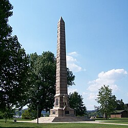
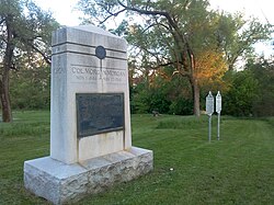
Located at the confluence of the Ohio and Kanawha rivers. Site of the only major action during Lord Dunmore's War, the Battle of Point Pleasant. Acquired by the state in 1901. The granite obelisk monument commemorating the battle was dedicated in 1909, and they were added to the state park system in 1956. The park features the Mansion House Museum (c.1796) and a monument to Cornstalk who is buried there. The park is listed on the NRHP.[25][67][181][190]
Named for two waterfalls about zero point five miles (0.80km) apart: one on the Marsh Fork and one on the Black Fork of Cabin Creek. One of three resort state parks funded by the EDA along with Canaan Valley Resort and Pipestem Resort. Contains a golf course, a reconstructed pioneer homestead serving as a living museum, and a lodge designed by TAC. Its diverse species of flora reflect an overlap of northern and southern ecosystems.[181][192][194]
Named for two fast-moving waterfalls of 12 feet (4m) and 18 feet (5m) in height on the Tygart Valley River. During the 19th century, a milling and industrial town flourished at this site.[201]
Initially developed as a state forest in 1926. One of West Virginia's first CCC camps was established here in 1933. The largest of West Virginia's state parks, it contains the 11-acre (4ha) Watoga Lake. A historic district containing the park's 103 CCC resources is listed on the NRHP.[130][204][206][207]
Consists of the pioneer homestead of Watters Smith who moved here with his wife Elizabeth in 1796. A log cabin similar to the original was reconstructed at the park along with period farm buildings. The Smith family home (c.1876) has also been restored as a museum. The park is listed on the NRHP.[67][209][210][212]
It was the only state park that allowed admission to African Americans until the park system were integrated in 1954. The park consisted of day-use picnicking facilities, but lacked a pool, hiking trails, campsites, and other amenities. Prior to the park's opening in 1949, African Americans were denied access to the state park system and were limited to the African American 4-H Camp at Camp Washington-Carver which was funded by the West Virginia State Collegeextension service.[31][32][37][214]
Initially constructed by the CCC, the park was named for its views of New River Gorge and the river's Horseshoe Bend. It was transferred to the NPS in 1990, and is managed as part of the New River Gorge National River. Grandview remains the home of Theatre West Virginia, which performs Hatfields and McCoys and Kermit Hunter's Honey in the Rock at Cliffside Amphitheater.[220][221][223] In 2021, the New River Gorge National River was redesignated as the New River Gorge National Park and Preserve.[224][225]
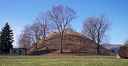
The Grave Creek Mound measures 69 feet (21m) tall and 295 feet (90m) in diameter. Built c.250–150 BCE, it is the largest Adena culture mound. It was purchased by the state in 1909 and maintained by the West Virginia State Penitentiary warden until 1970, when it became a state park. It was declared a National Historic Landmark in 1966. In 1996, the mound was transferred to the West Virginia Division of Culture and History, which maintains the mound and the Delf Norona Museum as the Grave Creek Mound Archaeological Complex.[26][228][230]
The state park system operated the monument from 1956 until 1978, when operation of the monument was returned to the society and the adjoining park transferred to the Corporation of Shepherdstown. The monument provides a panoramic view of the Potomac River valley and is a contributing property to the NRHP Shepherdstown Historic District.[27][233][234]
The park was leased to the state of West Virginia for the maintenance and conservation of the Mingo Oak, the oldest and largest living white oak (Quercus alba), until its felling in 1938.[236][237]
Located along Cheat Lake, the park and its 54-room lodge (1958) failed to develop as a tourist attraction. The lodge and 13 acres (5ha) were leased to the West Virginia Geological and Economic Survey in 1977. The remainder of the park went to a private owner in 1985 as part of a land swap for an added tract to Holly River State Park.[240]
Erected in 1924, the monument honors Morgan Morgan who is credited as the first permanent European settler in present-day West Virginia. Morgan settled in the Bunker Hill area around 1731 and is interred in a nearby cemetery. The monument and its roadside park were added to the park system in 1956 and transferred to the West Virginia Road Commission (present-day West Virginia Division of Highways) in 1970. The park is a contributing property of the NRHP Mill Creek Historic District.[28][247]
↑The WVDNR Parks and Recreation Section governs 39 state parks (including three rail trails), according to the West Virginia Blue Book (2018)[1][2] the West Virginia State Parks website (2025),[3] and the West Virginia Division of Natural Resources (WVDNR) Annual Report 2023–2024.[4] The West Virginia Blue Book (2018) lists the rail trails as part of its Directory of State Parks; however, the West Virginia State Parks website lists the rail trails separately.[1][2][5]
↑The WVDNR Parks and Recreation Section refers to all its lands (state parks, rail trails, and state forests) as "state parks", and all data released by the section is inclusive of state parks, rail trails, and state forests as "state parks".[12]
↑Registration form citations for state parks' NRHP listings are listed in the Remarks column of the Current state parks table.
↑In its report to the West Virginia Legislature in 1927, the West Virginia State Forest, Park and Conservation Commission recommended the following locations for scenic state parks: Blennerhassett Island in Wood County, Coopers Rock in Monongalia and Preston counties, Cranberry Glades and its surrounding area in Pocahontas County, Hawks Nest in Fayette County, Pinnacle Rock in Mercer County, and the intersection of the Seneca and Midland trails in Greenbrier County. Seneca Rocks and Smoke Hole Caverns were also recommended; however, the Commission acknowledged that both were slated to join the new Monongahela National Forest. The Commission also recommended the following locations for historic state parks: the Battle of Philippi battlefield in Barbour County, Berkeley Springs in Morgan County, the Caddell Rifle Range near Kingwood in Preston County, Droop Mountain in Pocahontas County, Fort Ashby in Mineral County, the Grave Creek Mound in Marshall County, the James Rumsey Monument in Jefferson County, the Morgan Morgan Monument in Berkeley County, and the Point Pleasant Monument in Mason County. The Commission also deferred to the West Virginia Historical Society for further recommended historic sites for preservation as state parks.[22]
↑Four parks established prior to Droop Mountain would later join the park system: the Point Pleasant Monument (now Tu-Endie-Wei) in Mason County was established in 1901 and became a state park in 1956;[25] the Grave Creek Mound in Marshall County was acquired by the state in 1909 and administered by the West Virginia State Penitentiary warden until becoming a state park in 1970;[26] the James Rumsey Monument in Jefferson County was dedicated in 1915 and made a state park in 1956;[27] and the Morgan Morgan Monument in Berkeley County was erected in 1924 and became a state park in 1956.[28]
↑The WVDNR Parks and Recreation Section administers Camp Creek State Forest and Camp Creek State Park together under a single superintendent.[90]
↑The WVDNR Parks and Recreation Section operates Chief Logan Lodge and Conference Center and Chief Logan State Park under separate management teams. While they are occasionally listed and counted separately in Parks and Recreation Section media, they are included together in this list as Chief Logan State Park.[116]
↑Booker T. Washington State Park was not listed among a list of West Virginia state parks in the 1959 West Virginia Blue Book[215] and in the 1960 NPS tabulation of U.S. state parks.[216] The 1958 West Virginia Blue Book did not include a listing of West Virginia state parks.[217]
↑"Brochure for Fairfax Stone Historical Monument State Park"(PDF). West Virginia Department of Commerce website. West Virginia Department of Commerce, West Virginia Division of Natural Resources, Parks and Recreation. Archived from the original(PDF) on November 30, 2017. Retrieved November 30, 2017.
West Virginia Legislature (2018a). "Section One: Executive". In Lee Cassis, Clerk of the West Virginia Senate (ed.). West Virginia Blue Book, 2017-2018(PDF). Charleston, West Virginia: Senate Clerk's Office. ISSN0364-7323. OCLC1251675. Retrieved July 11, 2023.
West Virginia Legislature (2018b). "Section Eleven: Departmental, Statistical & General Information". In Lee Cassis, Clerk of the West Virginia Senate (ed.). West Virginia Blue Book, 2017-2018(PDF). Charleston, West Virginia: Senate Clerk's Office. ISSN0364-7323. OCLC1251675. Retrieved July 11, 2023.
West Virginia State Park History Committee (1988). Where People and Nature Meet: A History of the West Virginia State Parks. Charleston, West Virginia: Pictorial Histories Publishing Company. ISBN978-0-933126-91-6. OCLC22116273.
This page is based on this Wikipedia article Text is available under the CC BY-SA 4.0 license; additional terms may apply. Images, videos and audio are available under their respective licenses.