Elakala Falls

Last updated
Elakala Falls
Elakala Waterfalls Swirling Pool Mossy Rocks.jpg
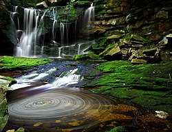
Elakala Waterfall #1, the most popular and well-known of the series of falls.
Elakala Falls
Location Blackwater Falls State Park, Tucker County, West Virginia, United States
Type Segmented block
Total height
  1. 1 - 35 feet (11 m), #2 - 15 feet (4.6 m), #3 - 40 feet (12 m), #4 - 20 feet (6.1 m) [1]
WatercourseShays Run [2]

The Elakala Falls are a series of four waterfalls of Shays Run [2] as it descends into the Blackwater Canyon in West Virginia. They are within Blackwater Falls State Park [3] and are quite popular among photographers, with the ease of access for the first waterfall, and the relatively low traffic of the other waterfalls in the series. [4] :219 The first of the series of waterfalls is 35 feet (11 m) in height and is easily accessible from park trails. It is the second most popular waterfall in the park. [1] From the official Elakala trail there is a bridge over the top of the first waterfall offering easy access and views. [4] :219 The remaining three waterfalls of the series are progressively more difficult to access, and have no official marked trails to them. [1] The gorge is nearly 200 feet deep at this section accounting for the difficulty of the descent to the lower waterfalls of the series.

Elakala Falls 2 Picture 2.jpg
The second falls
Elakala Falls 3 Picture 2 Edited.jpg
The third falls

The second waterfall is only 15 feet (4.6 m) tall and is the smallest in the series, yet remains popular by the well-worn path from the first falls. The third waterfall of the series is the highest at 40 feet (12 m) tall but is particularly difficult to reach. [1] It has a path worn to it but is very steep and rocky terrain. Traveling beyond the second waterfall should be considered for experienced hikers only due to the danger of descending the canyon without trails. The fourth and final waterfall of the series is considered quite dangerous to access, with no trails, and should not be attempted by inexperienced hikers. [4] :224–225

The name of the waterfalls comes from a Native American legend, although several significantly different versions exist. According to one account it involves a princess named Elakala who threw herself over the edge of the first waterfall when her lover scorned her. [1] Another account of the legend involves a Massawomee warrior named Elakala who was girl-shy and fell to his death from the falls while being pursued by two women of his tribe. [5] :598 Similar legends exist for many waterfalls in the eastern United States, and there is, of course, no way to confirm these stories. [1]

Related Research Articles

<span class="mw-page-title-main">Letchworth State Park</span> State park in New York state, United States

Letchworth State Park is a 14,427-acre (5,838 ha) New York State Park located in Livingston County and Wyoming County in the western part of the State of New York. The park is roughly 17 miles (27 km) long, following the course of the Genesee River as it flows north through a deep gorge and over several large waterfalls. It is located 35 miles (56 km) southwest of Rochester and 60 miles (97 km) southeast of Buffalo, and spans portions of the Livingston County towns of Leicester, Mount Morris and Portage, as well as the Wyoming County towns of Castile and Genesee Falls.

<span class="mw-page-title-main">Multnomah Falls</span> Waterfall in Oregon, U.S.

Multnomah Falls is a waterfall located on Multnomah Creek in the Columbia River Gorge, east of Troutdale, between Corbett and Dodson, Oregon, United States. The waterfall is accessible from the Historic Columbia River Highway and Interstate 84. Spanning two tiers on basalt cliffs, it is the tallest waterfall in the state of Oregon at 620 ft (189 m) in height. The Multnomah Creek Bridge, built in 1914, crosses below the falls, and is listed on the National Register of Historic Places.

<span class="mw-page-title-main">McCormick's Creek State Park</span> State park in Owen County, Indiana

McCormick's Creek State Park is the oldest state park in the U.S. state of Indiana, dedicated on July 4, 1916, as part of the state's centennial celebration. It is located 14 miles (23 km) west of Bloomington in Owen County. The park receives about 640,000 visitors annually.

<span class="mw-page-title-main">Lookout Mountain</span> Mountain in northwestern Georgia, United States

Lookout Mountain is a mountain ridge located at the northwest corner of the U.S. state of Georgia, the northeast corner of Alabama, and along the southeastern Tennessee state line in Chattanooga. Lookout Mountain was the scene of the 18th-century "Last Battle of the Cherokees" in this area during the Nickajack Expedition. On November 24, 1863, during the American Civil War, the Battle of Lookout Mountain took place here.

<span class="mw-page-title-main">Cloudland Canyon State Park</span> State park in Georgia, United States

Cloudland Canyon State Park is a 3,485 acres (14.10 km2) Georgia state park located near Trenton and Cooper Heights on the western edge of Lookout Mountain. One of the largest and most scenic parks in Georgia, it contains rugged geology, and offers visitors a range of vistas across the deep gorge cut through the mountain by Sitton Gulch Creek, where the elevation varies from 800 to over 1,800 feet. Views of the canyon can be seen from the picnic area parking lot, in addition to additional views located along the rim trail. At the bottom of the gorge, two waterfalls cascade across layers of sandstone and shale, ending in small pools below.

<span class="mw-page-title-main">Amicalola Falls State Park</span> State park in Georgia, United States

Amicalola Falls State Park & Lodge is an 829-acre (3.35 km2) Georgia state park located between Ellijay and Dahlonega in Dawsonville, Georgia. The park's name is derived from a Cherokee language word meaning "tumbling waters". The park is home to Amicalola Falls, a 729-foot (222 m) waterfall that is the highest in Georgia. However, an analysis conducted by the World Waterfall Data base suggests that the main part of the falls is 429 ft (131 m) in height, followed by a prolonged gently sloping run in which the flow drops another 279 ft (85 m). It is considered to be one of the Seven Natural Wonders of Georgia. An 8-mile (13 km) trail that winds past Amicalola Falls and leads to Springer Mountain, famous as the southern terminus of the Appalachian Trail, begins in the park. Amicalola Falls State Park also offers many hiking trails, a guest lodge, restaurant, cabins, a shelter for long-distance Appalachian Trail hikers, a campground, and access to the eco-friendly Len Foote Hike Inn.

<span class="mw-page-title-main">Yellowstone Falls</span> 2 waterfalls in Yellowstone National Park, Wyoming

Yellowstone Falls consist of two major waterfalls on the Yellowstone River, within Yellowstone National Park, Wyoming, United States. As the Yellowstone river flows north from Yellowstone Lake, it leaves the Hayden Valley and plunges first over Upper Falls of the Yellowstone River and then a quarter mile downstream over Lower Falls of the Yellowstone River, at which point it then enters the Grand Canyon of the Yellowstone, which is up to 1,000 feet deep.

<span class="mw-page-title-main">Uvas Canyon County Park</span> Park in California

Uvas Canyon County Park is a 1,147-acre (464 ha) natural park located in upper Uvas Canyon on the eastern side of the Santa Cruz Mountains, west of Morgan Hill, California. The park has several small waterfalls, some of which flow perennially, that feed into tributaries confluent with Uvas Creek. The park is part of the Santa Clara County Parks System, and facilitates picnics, hiking and overnight camping. It is one of the few parks in the area that allows dogs in the campgrounds.

The Potomac Highlands of West Virginia centers on five West Virginian counties in the upper Potomac River watershed in the western portion of the state's Eastern Panhandle, bordering Maryland and Virginia. Because of geographical proximity, similar topography and landscapes, and shared culture and history, the Potomac Highlands region also includes Pocahontas, Randolph, and Tucker counties, even though they are in the Monongahela River or New River watersheds and not that of the Potomac River.

<span class="mw-page-title-main">Blackwater Falls State Park</span> State park in Tucker County, West Virginia

Blackwater Falls State Park is located in the Allegheny Mountains of Tucker County, West Virginia, US. The centerpiece of the park is Blackwater Falls, a 62-foot (19 m) cascade where the Blackwater River leaves its leisurely course in Canaan Valley and enters rugged Blackwater Canyon. It is among the most photographed venues in the state and appears on calendars, stationery, and advertisements. The river is named for its tannin-darkened water.

<span class="mw-page-title-main">Tanner Trail</span> Grand Canyon hiking trail

The Tanner Trail is a hiking trail located on the South Rim of the Grand Canyon National Park, located in the U.S. state of Arizona. The trailhead is located at Lipan Point, a prominent lookout located to the east of the Grand Canyon Village, and the trail ends at the Colorado River at Tanner Rapids.

<span class="mw-page-title-main">Bushkill Falls</span>

Bushkill Falls is a series of eight privately owned waterfalls, the tallest of which cascades over 100 feet (30 m), located in Lehman Township, Pennsylvania in the Pocono Mountains. Water of the Little Bush Kill and Pond Run Creek descends the mountain, toward the Delaware River, forming Bushkill Falls, Bridal Veil Falls, Bridesmaid Falls, Laurel Glen Falls, Pennell Falls, and three additional, unnamed falls.

<span class="mw-page-title-main">Darwin Falls</span> Waterfall in Death Valley, California

Darwin Falls is a waterfall located on the western edge of Death Valley National Park near the settlement of Panamint Springs, California. Although there exists a similarly named Darwin Falls Wilderness adjacent to the falls, the falls themselves are located in and administered by Death Valley National Park and the National Park Service. There are several falls, but they are mainly divided into the upper and lower, with a small grotto in between. At a combined 80 feet (24 m), it is the highest waterfall in the park. The canyon is walled by dramatic plutonic rock.

<span class="mw-page-title-main">Eaton Canyon</span> Natural feature in the U.S. state of California

Eaton Canyon is a major canyon beginning at the Eaton Saddle near Mount Markham and San Gabriel Peak in the San Gabriel Mountains in the Angeles National Forest, United States. Its drainage flows into the Rio Hondo river and then into the Los Angeles River. It is named after Judge Benjamin S. Eaton, who lived in the Fair Oaks Ranch House in 1865 not far from Eaton Creek.

<span class="mw-page-title-main">Blackwater Canyon</span>

Blackwater Canyon is a rugged, heavily wooded, eight-mile (13 km) long gorge carved by the Blackwater River in the Allegheny Mountains of eastern West Virginia, USA. For many years, it has been the object of controversy as environmental activists have contended with industrial interests over its ultimate status.

<span class="mw-page-title-main">Salt Creek Falls</span> Waterfall in Lane County, Oregon

Salt Creek Falls is a cascade and plunge waterfall on Salt Creek, a tributary of the Middle Fork Willamette River, that plunges into a gaping canyon in the Willamette National Forest near Willamette Pass in Lane County, Oregon. The waterfall is notable for its main drop of 286 feet (87 m), ranking third highest among plunge waterfalls in Oregon, after Multnomah Falls and Watson Falls.) The pool at the bottom of Salt Creek Falls waterfall is 66 feet (20 m) deep.

<span class="mw-page-title-main">Havasu Creek</span> Stream in Arizona, United States of America

Havasu Creek is a stream in the U.S. state of Arizona associated with the Havasupai people. It is a tributary to the Colorado River, which it enters in the Grand Canyon.

<span class="mw-page-title-main">Waterfalls in Ricketts Glen State Park</span> Waterfalls in Ricketts Glen State Park in the U.S. state of Pennsylvania

There are 24 named waterfalls in Ricketts Glen State Park in the U.S. state of Pennsylvania along Kitchen Creek as it flows in three steep, narrow valleys, or glens. They range in height from 9 feet (2.7 m) to the 94-foot (29 m) Ganoga Falls. Ricketts Glen State Park is named for R. Bruce Ricketts, a colonel in the American Civil War who owned over 80,000 acres in the area in the late 19th and early 20th centuries, but spared the old-growth forests in the glens from clearcutting. The park, which opened in 1944, is administered by the Bureau of State Parks of the Pennsylvania Department of Conservation and Natural Resources (DCNR). Nearly all of the waterfalls are visible from the Falls Trail, which Ricketts had built from 1889 to 1893 and which the state park rebuilt in the 1940s and late 1990s. The Falls Trail has been called "the most magnificent hike in the state" and one of "the top hikes in the East".

<span class="mw-page-title-main">North Falls</span> Waterfall in Silver Falls State Park

North Falls is a waterfall located in the Silver Falls State Park at the east end of the city of Salem, in Marion County, in the U.S. state of Oregon. It is located in a privileged area on the west foothills where Mount Hood National Forest meets with the Middle Santiam Wilderness. Several prominent waterfalls are located in the Park along Trail of Ten Falls: South Falls, Drake Falls, Lower South Falls, and Winter Falls—among others.

<span class="mw-page-title-main">Twin Falls (Oregon)</span> Waterfall in Silver Falls State Park

Twin Falls is a waterfall located in the Silver Falls State Park at the east end of the city of Salem, in Marion County, in the U.S. state of Oregon. It is located in the west foothills where Mount Hood National Forest meets with the Middle Santiam Wilderness. Several prominent waterfalls are located in the Park along Trail of Ten Falls: South Falls, Drake Falls, Lower South Falls, and Winter Falls—among others.

References

  1. 1 2 3 4 5 6 "Falls of the Month, April 1999". Eastern Waterfall Guide. Retrieved June 26, 2010.
  2. 1 2 "Shays Run". Geographic Names Information System . United States Geological Survey. June 27, 1980. Retrieved July 23, 2010.
  3. "Elakala Waterfall". Great Lakes Waterfalls & beyond. Retrieved June 26, 2010.
  4. 1 2 3 Adams, Kevin (2003). Waterfalls of Virginia and West Virginia. Menasha Ridge Press. ISBN   0-89732-414-5.
  5. Fansler, Homer (1962). History of Tucker County, West Virginia. McClain Printing Company. A legend connected with the Falls of Elakala is that a Massawomee Indian warrior, named Elakala, was so girl shy it was an overpowering obsession, and in trying to escape from two Indian maidens who were pursuing him he ran too near the brink of the falls on Shays Run and fell to his death on the rocks below. As punishment for their rash act, the two maidens were banished from the tribe, went north and were accepted in the Seneca Tribe, where they married and reared families. Their sons, learning of their mothers' banishment, sought revenge on the Massawomees. They organized a war party of Senecas, marched south, annihilated the entire Massawomee Tribe, and returned with their scalps. According to the legend this conquest accounts for the extinction of the Massawomees, and the naming of the route of the march The Seneca Trail.

39°06′32″N79°29′56″W / 39.109°N 79.499°W / 39.109; -79.499