Related Research Articles

Garrett County is the westernmost county of the U.S. state of Maryland completely within the Appalachian Mountains. As of the 2020 census, the population was 28,806, making it the third-least populous county in Maryland. Its county seat is Oakland. The county was named for John Work Garrett (1820–1884), president of the Baltimore and Ohio Railroad. Created from Allegany County in 1872, it was the last county to be formed in the state.
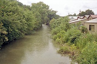
New Creek is an 18.4-mile-long (29.6 km) stream in eastern West Virginia, United States. It is the third major West Virginia tributary to the North Branch Potomac River. Via the Potomac, it is part of the watershed of Chesapeake Bay.

Saddle Mountain is a section of New Creek Mountain in the Ridge and Valley physiographic province of the Appalachian Mountains in Mineral County, West Virginia. The mountain is so named for its shape. It is best viewed from Skyline which is located to the west along US 50 at the intersection with WV 42, atop the Allegheny Front. The mountain's elevation is 3,074 feet (937 m).
Lunice Creek is a 7.3-mile-long (11.7 km) tributary of the South Branch Potomac River, belonging to the Potomac River and Chesapeake Bay watersheds. The creek is located in Grant County, West Virginia. Lunice Creek is created by its North and South Forks and empties into the South Branch at Petersburg.
Mill Creek is a 14.5-mile-long (23.3 km) tributary of Opequon Creek, belonging to the Potomac River and Chesapeake Bay watersheds, located in Berkeley County in West Virginia's Eastern Panhandle. Its name reflects its past as a popular site for various types of mills, beginning with one constructed by Morgan Morgan in the mid-18th century near his cabin in present-day Bunker Hill.

Tuscarora Creek in Berkeley County, West Virginia, is an 11.4-mile-long (18.3 km) tributary of Opequon Creek, which drains into the Potomac River in the Chesapeake Bay watershed.
Oregon Jack Provincial Park is a provincial park in British Columbia, Canada located in the Clear Range west of Ashcroft. It protects the limestone canyon of Oregon Jack Creek, at the head of which is a waterfall named the Notch, above which is included a wetland area. The site was an important First Nations site and there are pictographs, culturally modified trees and a site known as the Three Sisters Rock Shelter.
Buffalo Creek is a 4.1-mile-long (6.6 km) free-flowing tributary stream of the South Branch Potomac River, itself a tributary of the Potomac River, making it a part of the Chesapeake Bay watershed. Buffalo Creek is located in west-central Hampshire County in the U.S. state of West Virginia. Because the stream flows through several small farms, Buffalo Creek primarily serves agriculture purposes with segments used for livestock watering.
The Mon River Trail is a rail trail located in West Virginia, United States.
The Caperton River Trail is a rail trail located in West Virginia, United States.
The Deckers Creek Trail is a rail trail located in West Virginia.

Deckers Creek is a 24.6-mile-long (39.6 km) tributary of the Monongahela River that runs through north-central West Virginia. It begins west of Arthurdale and flows southeast, then north, then northwest towards Morgantown, where it empties into the Monongahela River. The stream has been contaminated by various sources, though largely due to extractive resource mining and improper sewage disposal. Recently, a conservation effort has been launched and conditions are improving, as the area continues to develop for recreational purposes.
Hollywood, Pittsylvania County is an unincorporated community in Pittsylvania County, in the U.S. state of Virginia.
Patterson Creek is a 51.2-mile-long (82.4 km) tributary of the North Branch Potomac River in West Virginia's Eastern Panhandle, in the United States. It enters the North Branch east of Cumberland, Maryland, with its headwaters located in Grant County, West Virginia. Patterson Creek is the watershed for two-thirds of Mineral County, West Virginia. The creek passes through Lahmansville, Forman, Medley, Williamsport, Burlington, Headsville, Reeses Mill, Champwood, and Fort Ashby.
Bills Creek is a stream in the U.S. state of West Virginia. It is a tributary of Sugar Creek.
Canoe Run is a stream in the U.S. state of West Virginia. It is a tributary of West Fork River.
Hunter Fork is a creek in Barbour County, West Virginia. It is a tributary of Sugar Creek, which flows into the Tygart Valley River.
Licking Creek is a stream in the U.S. state of West Virginia.
Red Oak Creek is a stream in the U.S. state of West Virginia.
Teter Creek is a stream in the U.S. state of West Virginia. It is a tributary to the Tygart Valley River.
References
- ↑ U.S. Geological Survey Geographic Names Information System: Rhine Creek (West Virginia)
- ↑ Mockridge, Norton (Apr 22, 1971). "West Virginia Takes Name Prize". Toledo Blade. p. 29. Retrieved 21 May 2015.
39°20′18″N79°29′46″W / 39.33833°N 79.49611°W